Traffic and Transportation in Turin City, Italy
Turin was the first capital of modern Italy, and was the host of the 2006 Winter Olympic Games. While it’s not a famous tourist destination like Florence or Rome, the setting is pleasant, with the Po River flowing through the city, the genteel hills overlooking the city and scattered with pleasant villas and surrounded by the Italian Alps off in the distance. This is why the famous architect Le Corbusier defined Turin as “the city with the most beautiful natural location in the world”.
In the 18th century Savoy, newly proclaimed a kingdom, embarked on an urban design project for its capital Turin. At this time many public squares, grand boulevards and royal palaces were built in order to make the city fit for a capital. After 1801 when Napoleon conquered the city, he created more large avenues in order to allow his troops easier movement, further altering the city’s layout.
Overview
The city one time had a large number of rail and road work sites. This activity has increased as a result of the 2006 Winter Olympics, parts of it had long been planned. Some of the work sites deal with general roadworks to improve traffic flow, such as underpasses and flyovers, Two projects are of major importance and radically changed the shape of the city.
One is the Spina Centrale (“Central Spine”) project which includes the doubling of a major railway crossing the city, the Turin-Milan railway locally known as Passante Ferroviario di Torino (“Turin Railway Bypass”). The railroad previously ran in a trench, which will now be covered by a major boulevard running from North to South of Turin, in a central position along the city. Porta Susa, on this section, will become Turin’s main station to substitute the terminus of Porta Nuova with a through station. Other important stations are Stura, Rebaudengo, Lingotto and Madonna di Campagna railway stations, though not all of them belong to the layout of the Spina Centrale.
The other major project is the construction of a subway line based on the VAL system, known as Metrotorino. This project is expected to continue for years and to cover a larger part of the city, but its first phase was finished in time for the 2006 Olympic Games, inaugurated on 4 February 2006 and opened to the public the day after. The first leg of the subway system linked the nearby town of Collegno with Porta Susa in Turin’s city centre. On 4 October 2007, the line was extended to Porta Nuova and then, in March 2011, to Lingotto. A new extension of the so-called Linea 1 (“Line 1”) is expected in the near future, reaching both Rivoli (up to Cascine Vica hamlet) in the Western belt of Turin and Piazza Bengasi in the Southeast side of the city. Furthermore, a Linea 2 is in the pipeline that will connect the south-western district of Mirafiori with Barriera di Milano in the north end. In June 2018, the project entered the public consultation phase with the proposed list of 23 stations published on the city’s website.
The main street in the city centre, Via Roma, runs atop a tunnel built during the fascist era (when Via Roma itself was totally refurbished and took on its present-day aspect). The tunnel was supposed to host the underground line but it is now used as an underground car park.
The city has an international airport known as Caselle International Airport Sandro Pertini (airport code: TRN), in Caselle Torinese, about 13 km (8 mi) from Turin’s centre – connected to the city by rail (from Dora Station) and bus (from Porta Nuova and Porta Susa railway stations).
Intercity transportation
Airports
Turin Airports
Currently the city of Turin has an airport in international: the Turin Airport. In addition, the Turin-Aeritalia airport is present in Corso Marche (ICAO Code: LIMA); inaugurated in 1916, after the construction of the Caselle airport it remained in use as a general and tourist aviation facility, flanked by a flight school for airplanes and helicopters and the headquarters of helicopter rescue and civil protection aircraft.
There are international flights to Turin from Amsterdam, Bacau, Barcelona, Berlin (SXF), Birmingham, Bristol, Brussels (BRU & CRL), Bucharest, Casablanca, Chisinau, Copenhagen, Dublin, Edinburgh, Fez, Frankfurt, Gothenburg, Iasi, Ibiza, Kyiv (KBP), Leeds, London (LGW, LTN & STN), Madrid, Malta, Manchester, Marrakesh, Menorca, Moscow (DME), Munich, Mykonos, Palma de Mallorca, Paris (CDG), Skiathos, Seville, Stockholm (ARN), Tirana, Valencia, & Warsaw (WAW). Domestic destinations are Alghero, Bari, Brindisi, Cagliari, Catania, Comiso, Lamezia Terme, Lampedusa, Naples, Olbia, Palermo, Pantelleria, Reggio Calabria, Rome (FCO), and Trapani. Some of these are seasonal, and the airport is especially busy in ski season with travellers to the resorts in Valle d’Aosta and the western Italian Alps.
Most flights are with budget airlines such as Ryanair and Blue Air, even for domestic flights, or with ski package operators. There’s just a single terminal, easy to navigate, with the usual range of shops airside after security: Heinemann run the duty-free franchise. Departure gates 1-13 are domestic / Schengen, gates 14-22 beyond passport control are non-Schengen. There’s a back-up passport control point for gates 19-22, to give the airport flexibility in the allocation of areas, but it’s normally empty and you can stroll through to the toilets by gate 22. But there’s otherwise no facilities in the non-Schengen area, so don’t go through passport control until an hour before your flight.
From airport to the city, best is the Sadem bus, running every 15-30 mins between airport, Caselle town, and Turin Porta Susa and Porta Nuova railway stations, taking 45-55 mins; some buses extend to Lingotto. If possible buy your ticket from a kiosk or machine in the arrivals area, for €7. But these machines are never working so you’ll likely have to buy them on the bus for €8. If you buy a Turin + Piemonte Card (as in “See”), the ride is only €5.
By train is possible but inconvenient. Walk west from the terminal to Caselle-Aeroporto railway station, which is on the branch line between Lanzo & Germagno in the hills to the north, and Dora station in Turin. Trains run every 30 mins and take 20 mins to Dora, from where you’d need to transfer to a city bus. The train fare is €2.70 but better value is the Integrato B at €3, valid for two hours of city transport. Buy it from the travel kiosk in arrivals.
By taxi to the city centre is around €40, and a private car transfer €100. There are car hire desks in arrivals: you don’t want a car in the city, but would need one to explore the mountains.
Disused Airports
Other airports for reaching Turin are Milan Malpensa MXP, Milan Linate LIN, and Bergamo BGY. Of these, Malpensa has the best range of flights, and best onward transport: the SADEM bus runs direct from MXP Terminals 1 & 2 to Turin Porta Susa, hourly 08:00-22:00 and at midnight. The ride lasts 2 hours and costs €22, buy tickets in Malpensa arrival hall or online.
Turin Mirafiori – The first airport in the city was that of Mirafiori, built for military purposes in 1910 and which in the following years became the most important in Italy. After the decommissioning, the area was converted into a public park named after Gustavo Colonnetti.
Turin Piossasco – Cerrina Airport (ICAO Code: LILT).
Railways
Turin is the third Italian railway junction. The railway network within its borders consists mainly of RFI railway lines but also of local GTT lines.
The urban section under the responsibility of the GTT is the one that starts from Torino Dora and goes to the northern outskirts on the border with the municipality of Venaria Reale (towards Caselle Torinese – Sandro Pertini Airport – Ceres).
The main railway lines that depart from Turin are those that go towards Genoa (via Asti and Alessandria), towards Milan (via Novara and Vercelli) and towards France (via Bardonecchia and the Frejus railway tunnel) and Ventimiglia (via Cuneo and the Colle di Tenda railway tunnel). Then there are minor lines towards Ivrea – Aosta, Mondovì – Savona, Pinerolo – Torre Pellice, Trofarello – Chieri, Cirié – Lanzo Torinese -Ceres and Rivarolo Canavese – Cuorgnè – Pont Canavese.
Turin’s main railway station is Porta Susa. All international and long-distance trains call here, with direct services to Paris Gare de Lyon (6 hours) via Lyon, to Milan (50 min), Aosta (90 min), Genoa (90 min), Bologna (2 hr), Florence (2 hr 45), Venice (3 hr 30), Rome (4 hr), Naples (6 hr), Bari (8 hr) and by sleeper to Reggio DC (18 hr) for Sicily. For Switzerland, Germany and Austria, change in Milan. The Frecciarossa trains rush between Turin and Milan in 50 mins for a fare of €35, reservations compulsory and they do sell out. If you’re not in a hurry, standard Trenitalia trains via Chivasso and Novara take 1 hr 45 and the fare is only €13.
The old Porta Susa station at Piazza XVIII Dicembre is shut and empty, and horse-drawn buses ply there no more. The new station, adjacent south, opened in 2013: it’s a long low steel hangar that looks like it wants to be a garden centre. There are ticket offices and machines, toilets, a cafe and a convenience store; there’s no left luggage facility. As of early 2019, almost none of the retail units have been let, so the interior concourse is just a long bare corridor. There’s limited seating and if you have an extended wait, you might be better in one of the nearby bars and cafes. Find these by exiting west onto Corso Inghilterra or going a little north (past the old station) onto Corso San Martino. Porta Susa station is on the Metro line, with a bus terminus (including for the airport bus) outside east on Corso Bolzano.
Porta Nuova station doesn’t have international trains but has all the long-distance Italian services, travel times as above. It’s a terminus station so through-trains reverse direction. Lots of shops and cafes here, and a left-luggage office open daily 08:00-20:00, charge €6 per bag for five hours. There’s even a piano. Porta Nuova is on the Metro line, with lots of buses (including the airport bus) stopping outside.
Turin’s other stations include Stura north of the city, and Lingotto in the south near Eataly and the Automobile Museum. All stations are managed by Trenitalia, the Italian state railways.
Motorway connections
Five motorways converge on Turin (among which the one heading towards France is particularly important) and a motorway link:
A4 Turin – Milan – Brescia – Verona – Venice – Trieste
A5 Turin – Ivrea – Aosta – Mont Blanc Tunnel
A6 Turin – Fossano – Savona
A21 Turin – Alessandria – Piacenza – Brescia
A32 Turin – Susa – Bardonecchia – Frejus road tunnel
RA10 Turin – Caselle Torinese – Turin-Caselle Airport
Tangentials
The Turin ring road is the A55, divided into the North ring road and the South ring road, it runs from north east to south east passing in a semicircular way from the west. It also includes the route from Turin to Pinerolo.
The missing stretch to the east (Turin’s Tangenziale Est) is under construction.
The Turin urban highway system also includes the 3.13 km connection to the A4 Turin-Milan and the SS11.
By bus
Flixbus have direct buses to Turin from Paris (10 hr), Lyon (5 hr), Geneva (4 hr 30), Zürich (6 hr), Munich (9 hr), Ljubljana (10 hr), Zagreb (12 hr) and Budapest (16 hr). Services within Italy are from Genoa (2 hr 30), Bologna (6 hr), Florence (7 hr), Venice (6 hr 30), Trieste (8 hr), Rome (10 hr), Naples (11 hr) and Catania (22 hr). Buses from Milan are about every hour, taking 2 hours, and advance online fares can be as low as 4 euro. Many other destinations can be reached by a single change of bus.
Marinobus have a direct bus from Paris (25 hr) via Frankfurt and Stuttgart.
Traffic in the city
Roads
Public transport
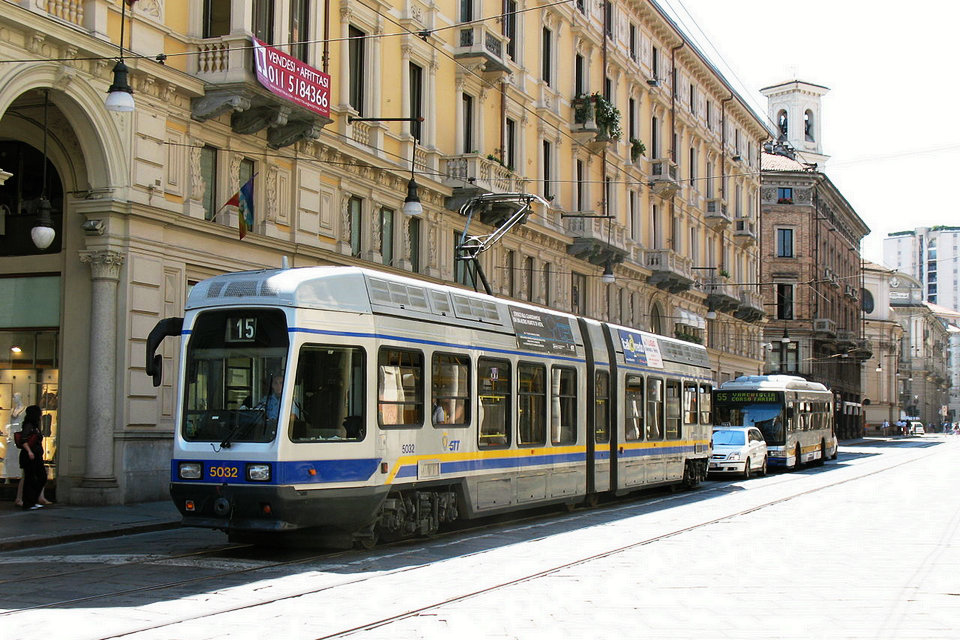
Turin has an efficient, integrated system of buses, trams and Metro all operated by GTT. These run 06:00-00:30, and out of hours there are night buses fanning out from Piazza Vittorio Veneto. A comprehensive network map is available on the GTT website. On 5T website it’s also possible to check real-time running.
You must buy your ticket before you get on and validate it as soon as you board. All tabaccherie (tobacconists) sell transport tickets as do some bars and kiosks at stations. The standard ticket is the “City + Suburban 100”, valid for 100 mins for unlimited bus rides plus one journey on the Metro. In 2020 this costs €1.70; daily, 48-hr and 72-hr tickets are available for €4, €7.50 and €10 respectively. Longer season tickets will need photo ID. The spot fine for travelling with an unvalidated ticket, or without one, is €25.
Bus and tram stops are clearly marked with yellow signs, and display maps of the city routes. There may be electronic indicators at the stop and on board.
Urban mobility
The Turin transport network is managed by GTT, an acronym for Gruppo Torinese Trasporti, born in 2003 from the merger of ATM and SATTI. In the municipal area of Turin, the metropolitan and urban railway mobility system extends for a total of 29 km, divided into 8 lines served by 28 stations. For its green purchases, the city of Turin reached the second place of the European Gpp Award of 2016, behind the cities of Vienna and in front of the metropolitan city of Turin.
Subway
In Turin the first automatic metro in Italy is in operation using light, frequent and driverless vehicles to minimize waiting times and adapt the service to the needs of the different time slots. They are also particularly safe, given that access to the wagons is allowed only when the train is actually present, while for the rest of the time the rails are completely inaccessible. In 2018, the path of the second line was approved, which will be completed in full over ten years.
The 23 VAL208-Turin trains travel under corso Francia, corso Vittorio Emanuele II and via Nizza; 13.4 km to be covered in 20 minutes, connecting the Fermi (Collegno) interchange car park to the “heart” of Turin and the Porta Susa and Porta Nuova railway stations to end at the Lingotto Fiere exhibition center.
The Metro, opened in 2006, is a single line with driverless trains. The southern terminus is Lingotto, near the mainline Lingotto station, Exhibition & Trade Centre, Eataly and the Automobile Museum. The line runs north under Via Nizza stopping at Spezia, Carducci, Dante, Fermata 8226 and Marconi to Porta Nuova railway station. It there turns west beneath Corso Vittorio Emmanuele II stopping at Re Umberto and Vinzaglio, then north again to Porta Susa railway station and Piazza XVIII Dicembre. It then runs west under Corso Francia into the suburbs, stopping at Principi d’Acaja, Bernini, Racconigi, Rivoli, Monte Grappa, Pozzo Strada, Massaua, Marche, and Paradiso to end at Fermi. Fares are the same as for buses, eg a 100-min single journey including bus transfers is €1.70, it’s automatically validated by passing the platform entrance gates.
By car
In Turin it is quite easy to get around by car due to the basically quadrangular plan of the city and the large boulevards it has, although sometimes the system of boulevards and alleys creates confusion. Some streets in the center (appropriately marked also with LED panels) are forbidden to private traffic at set times and, in the case of a road reserved for public transport, for all 24 hours.
You need to beware the many restricted-entry streets, trams, and other motorists who may regard red lights and speed limits as merely advisory. A good central parking garage is beneath Piazza Vittorio Veneto is 1 Parcheggio Vittorio Park. It is suggested to pay particular attention in the area north of Piazza della Repubblica in the direction of the motorway entrance (Corso Giulio Cesare, Corso Vercelli…) as there are pedestrian investments with a greater incidence than the rest of the city.
Car rentals: as well as the airport rental kiosks, there are down-town rental offices, eg Hertz just outside Porta Susa train station. There are three car sharing services in Turin, Car2Go, Enjoy and BlueTorino (which uses 100% electric cars). An electric scooter sharing service is run by MiMoto.
Taxi
The city of Turin has around 1600 taxis with 24-hour service. Taxis in Torino start the meter the moment your call is received. It is not customary to hail a taxi on the street, but there are taxi ranks at the main railway stations, at the corner of Via Sacchi and Corso Vittorio Emanuele II, and elsewhere. You can also book via the WeTaxi app.
By bicycle
The city has a network of bicycle paths, though they’re not all in good condition, and pedestrians will try to claim right of way. On the roads, cars and motor scooters will scythe across your path, and as for the trams…
A bike-sharing service is operated by ToBike. They have some 140 bike stations across the city, and their website shows real-time availability of bikes and docking stations. But first you have to register – easy if you’re a resident, and your card is mailed to you within a couple of days. That doesn’t work for short visits, so try presenting yourself at the Tobike shop in Via Santa Chiara 26/F, or at Turismo Torino in Piazza Castello. There are other outlets (eg Eataly in Lingotto) but they only sell annual cards. There’s also an app you can use, Bicincittà, then access bikes by your mobile instead of by a card, it’s not clear if this gets around the problem of not having a local mailing address.
Choose your Tobike card period: €5 for one day, €8 for one week or €25 for one year. Your first 30 mins on the bike is free, for unlimited trips providing you dock the bike between trips. Thereafter charges apply, up to the maximum permitted use of four hours.
How to orient yourself
Center
Via Garibaldi corresponds to the Decumanus Maximus of the Roman era. It is a pedestrian area and connects piazza Castello with piazza Statuto.
The first is the most famous town square. Palazzo Reale and Palazzo Madama overlook it. Piazza Statuto is surrounded by arcaded buildings from the second half of the 19th century. Corso Vittorio Emanuele II runs from east to west in the south of the center. At Piazza Carlo Felice are the entrances to the Porta Nuova railway station, the most important in Turin.
The center is bordered to the north by the very long Corso Regina Margherita which starts from the bridge of the same name over the Po and ends after 9 km at the junction corresponding to the “A55”
On the left of Corso Regina Margherita (facing the river) there are the Royal Gardens and in Via Montebello the Mole Antonelliana, symbol of Turin. A little further on is Piazza della Repubblica, home to a large open-air market. A historic flea market is held there every Saturday morning, known as Balôn.
Among the streets that run in a south-north direction, the most important is via Roma which starts from the Porta Nuova station and ends in Piazza Castello. About halfway along it forms Piazza San Carlo, the most scenic in Turin, closed on its south side by the two twin churches of Santa Cristina and San Carlo, both from the 18th century, and on the east and west sides by buildings with arcades.
Palazzo Carignano is one of the most important buildings in Turin and is also part of the Unesco heritage Savoy residences one of the most beautiful examples of Italian Baroque, in 1848, Palazzo Carignano became the seat of the Chamber of Deputies of the Subalpine Parliament
Other neighborhoods
Aurora district – North of the center, beyond Viale Regina and Piazza della Repubblica, the Aurora district extends on both banks of the Doria Riparia and began to develop in the seventeenth century, when tanners and silk artisans settled there. Today the Aurora district is a multi-ethnic district. In the early 2000s it enjoyed a very bad reputation, which fortunately the current redevelopment is downsizing.
San Salvario – Extending south of the center, beyond corso Vittorio Emanuele II up to corso Bramante, the district of San Salvario is separated from the left bank of the Po by the famous Parco del Valentino, which surrounds the castle of the same name whose shapes recall those of castles of the Loire and hosts the Borgo Medievale, a late 19th century reproduction of Piedmontese or Aosta Valley medieval villages. Today San Salvario is, like the Aurora district, a multi-ethnic district. In recent years it has become one of the places of the Turin nightlife with many clubs located between Corso Marconi and Corso Vittorio Emanuele II.
Nizza Millefonti – Also called “Molinette”, the district extends south of San Salvario, along the riverside. There is the former Fiat factory “il Lingotto” transformed following an intervention by Renzo Piano into a congress center with a large Auditorium. It houses the Giovanni and Marella Agnelli Art Gallery and the Automobile Museum.