National Nature Reserve of the Haute Chaine du Jura, Valserhône, France

The national nature reserve of the upper Jura chain (RNN112) is a national nature reserve located in Auvergne-Rhône-Alpes. A true emblematic mountain, the Haute Chaine du Jura has been, for the most part, classified as a National Nature Reserve (RNN). Classified in 1993, it occupies an area of 10,909 hectares, which makes it the fourth largest in mainland France in terms of surface area. It protects the highest link in the Jura massif.
With nearly 11,000 hectares, it is one of the largest in mainland France (4th in surface area). It corresponds to the most eastern link, the narrowest but also the highest of the whole massif. Ranging from 580 m to 1720 m in altitude, the altitudinal contrast gives this territory a great diversity of flora and fauna. The landscapes and environments that compose it are varied and the species that live there are as remarkable as they are fragile.
The reserve is located on the anticline of the Jura Mountains where the highest peaks of the Jura chain are located (Crêt de la Neige, Le Reculet…). It is bounded to the north by the Franco-Swiss border south of the summit of La Dôle and to the south by the cluse formed by the Rhône between the Grand Crêt d’Eau and the mountain of Vuache. To the west of the reserve is the Valserine valley and to the east is the Pays de Gex and the Léman valley. The reserve is also located on the territory of the Haut-Jura Regional Natural Park, of which confusion between the two entities is frequent.
Welcoming throughout the seasons to walkers, professionals (mountaineers, foresters, etc.), hunters and naturalists, the Nature Reserve is an accessible territory where many uses coexist. The reserve is located in the department of Ain on the territory of 18 communes of the Pays de Gex, but none of these is entirely included in the reserve. These are the municipalities of: Bellegarde-sur-Valserine, Chézery-Forens, Collonges, Confort, Crozet, Divonne-les-Bains, Échenevex, Farges, Gex, Lancrans, Léaz, Lélex, Mijoux, Péron, Saint-Jean- de-Gonville, Sergy, Thoiryand Vesancy.
Jura massif
The Jura is a mountain range located in Western Europe, mainly along the border between France and Switzerland, north-west of the Alps. It is characterized by a crescent shape extending over 340 km between Basel and Voreppe, following the curvature of the Alpine arc. Culminating at an altitude of 1720 m at the top of the crêt de la Neige, the Jura massif is characterized by a harsh semi-continental to mountain climate, despite its modest altitude and its geographical position. Its geologycomplex makes it a reference model in many geological disciplines and its name was at the origin of the name of the geological period of the Jurassic.
Geography
The Jura massif forms a crescent-shaped chain over 340 km long between Dielsdorf (Zurich, Switzerland) and Voreppe (Isère, France). Its width varies by a few kilometers at its ends, reaching a maximum of 65 km between Besançon and Neuchâtel. Located largely on the border between France and Switzerland, the massif is traditionally separated into two entities, called the “French Jura” and the “Swiss Jura”, depending on which side of the border we are on. Its area is estimated at around 14,000 km 2, with 9,860 km 2in France, where it is one of the six mountain ranges in the metropolis, and 4,140 km 2 in Switzerland, where it is one of the three large regions.
The Jura massif is delimited by a set of depressions: Bresse to the west; the Swiss plateau to the east, which separates it from the Alps; the Rhine ditch to the north, as well as the Belfort gap which separates it from the Vosges mountains. It is bordered to the north-west by a set of lowlands, attached to the Paris basin, and by the small massif of the Serre. To the south, the reliefs of the massif gradually merge with those of the Chartreuse and Vercors. Its southern geographical limit is considered to be the salient of the Rhône, on the border between Bugey and Savoie. However, the reliefs of the Savoyard foreland, as well as the Salève, considered geographically as belonging to the Prealps, have been identified by geologists as an integral part of the Jura, in view of their lithological and structural characteristics.
From an administrative point of view, the Jura massif crosses, in France, three regions and nine departments: Bourgogne-Franche-Comté (Doubs, Jura, Saône-et-Loire and Territoire de Belfort) , Auvergne-Rhône-Alpes (Ain, Isère, Haute-Savoie and Savoie) and the Grand Est (Haut-Rhin) . On the Swiss side, it crosses eight cantons: Aargau, Basel-Country, Bern, Jura, Neuchâtel, Solothurn,Vaud and Zurich.
Geology
The Jura gave its name to a famous period of our planet, the Jurassic, during the secondary era. It was at this time that the sediments going to form the Jura range were deposited. During the Jurassic, the region was composed of coral islands with shallow lagoons located at the edge of the Tethys Ocean (Alpine Ocean), with a biological profusion comparable to present-day Micronesia.
During the Cretaceous, the Jura will gradually emerge. Much later, at the end of the Tertiary (Neogene) era, the thrust of the alpine massif will lead to the deformation of the sedimentary series, which will crease and fault. The Jura will then acquire its current form of “crescent”, which bypasses the north-west of the Alpine massif.
The Jura, made up of limestone rocks, therefore generally permeable, struggles to retain water within it. The result is a complex karstic system where the alternation of limestone and marly banks conditions the presence or absence of water on the surface. The areas where limestone outcrops are in fact characterized by an infiltration of meteoric water towards an important underground hydrographic network, a process which is reflected on the surface by the presence of geomorphological forms characteristic of karstic areas (sinkholes, lapiaz, chasms, etc.). On the contrary, areas of marly outcrop (substrateimpermeable clay) are characterized by a return of water to the surface hydrographic network (resurgences, fountains, springs, etc.) or by the presence of areas of water stagnation (lakes, peat bogs, marshes, etc.) which cannot infiltrate into limestone aquifers. There are also many lakes of glacial origin in the Jura which are located at the bottom of valleys where a moraine substrate dating from the great Quaternary glaciations (Günz, Mindel, Riss,Würm) guarantees the waterproofing of the basement.
A coal basin is identified at two points in the massif: one partially exploited for its gas around Lons-le-Saunier and another larger, partially exploited, located to the north between the Jura and Vosges massifs, which includes the east of Haute-Saône, the Territoire de Belfort and the south of Haut-Rhin.
Hydrography
The Jura massif receives very large quantities of water, between 1,000 mm and more than 2,000 mm per year on the highest peaks. This has the consequence of creating many powerful rivers such as the Ain, the Doubs, the Loue, the Areuse, the Orbe or the Ill.
The Jura has many lakes of natural origin, as well as reservoirs used for hydroelectric production, like the reservoirs located on the course of the Ain. Among the natural lakes, there is a significant concentration of these bodies of water within the Jura lakes region, located in France. This region has more than ten lakes of glacial origin. Going up to the Haut-Jura, the Joux valley has several natural lakes, including the largest in the massif, Lac de Joux. In the upper Doubs valley, is also the Saint-Point lake and other small natural water expanses. In the south of the massif, other lakes are present such as Lake Nantua. At the southern end of the massif, in the Savoie department, the Jura has another large lake: Lac d’Aiguebelette. The Lake Bourget, the largest located entirely natural lake in France, is also considered part of the Jura, but also the Alps.
Climate
Strongly marked by the relief of the massif, the Jura as a whole is exposed to a humid mountain climate typical of continental (Cfb for the Köppen classification) , because the temperature variations are very important between summer and winter. Cold and precipitation increase with altitude.
Precipitation is very abundant over the entire Jura massif, rarely less than 1000 mm per year. The wettest points are the peaks of Haut-Jura culminating above 1,400 meters with peaks of over 2,000 mm, not far from the rainfall records of metropolitan France. The inner eastern border of the Jura massif is a little less watered. The Jura therefore experiences a lot of precipitation, in winter it is mainly in the form of snow above 800 meters above sea level. However, during the mildest winters, the rain-snow limit can be around 1,400 or 1,600 meters on average. Snow is therefore rarer there.
Regarding temperatures, the Jura is subject to two major influences given the orientation of the valleys of the massif: the southwest flow (mild and humid in winter, hot and stormy in summer) and the northeast flow (freezing in winter). winter). Temperatures can vary greatly depending on the season and from one place to another. Certain valleys are subject to a “cold basin” effect with, for example, an absolute cold record in La Brévine, Switzerland, of −41.8 ° C (1987); in Mouthe, France, the record approved by Météo-France is −36.7 ° C (January 13, 1968). In this same city, the heat record is 35.7 ° C (July 31, 1983). This is an annual maximum amplitude of 72.4 ° C. The summer is therefore relatively hot, especially given the average altitude of the massif.
Natural heritage
Vast nearly 11,000 hectares, the Haute Chaîne du Jura National Nature Reserve occupies most of the “Haute Chaîne du Jura” in the Ain department. This stretches for 40 kilometers from the Vaud border in the north to the Fort-l’Écluse gorge in the south. It is the most eastern, narrowest but also the highest link in the whole massif. Its highest point, the Crêt de la Neige (1720 m), hardly emerges from the crest line: Mont Rond (1596 m), Colomby de Gex (1689 m), Reculet (1718 m) and the massif du Grand Crêt d’Eau (1,621 m).
Folded then faulted, as a backlash to the uplift of the Alps, in the Tertiary era (which includes 2 periods: the Paleogene and the Neogene), then subjected, 20,000 years ago still, to glacial erosion, its relief is tormented. All forms of Jura relief are well represented there.
The “mountains” which straddle the Valserine valley towards the west, the numerous faults, glaciers, frost and even water have favored the formation of anticlinal valleys (Creux de l’Envers), glacial cirques (Creux de Narderans, Creux de Praffion), cliffs and “balmes” (vaults, swallowtail pass), scree, moraine deposits. The many forms of dissolution of surfaces such as lapiazes, sinkholes, hollows and pits bear witness to the intense activity of karst.
The amplitude of the drop, more than 1,200 meters between the peaks and the lowest points, on the lowlands or Fort-l’Écluse, favors the layering of the environments. The double exposure of the two slopes, south-east for the Pays de Gex and north-west for the Valserine, accentuates the contrasts. The ridges swept by winds in all seasons, offer extreme living conditions. The diversity of ecological factors determines the very great diversity of natural environments, of its fauna and flora.
Wildlife
With currently 205 species of vertebrates identified, the Haute Chaîne du Jura has a strong animal biodiversity. The mountainous character of the fauna is marked by the presence of populations of mammals and birds, typical of forests and mountain ridges. Some species are emblematic, such as the Capercaillie, the Wood Grouse, the Eurasian Lynx, the Golden Eagle, the Three-toed Woodpecker or the European Owl.
Of the 143 species of birds recorded, 91 are breeding and 127 species are protected at the national level. Paradoxically, this is not the case for the emblematic animal of the Haute Chaîne, the Capercaillie, or the second “star” grouse, the Wood Grouse, but it has not been hunted on the Jura massif since 1974..
The largest population of Chamois in the Jura massif (600 individuals) roams scree, grassy flats or forest undergrowth in search of its food and switches, depending on the time and season, from one slope to the next. ‘other.
Regarding bats, 23 species are listed on the Haute Chaîne.
Reptiles and amphibians are each represented by 7 species: Viviparous lizard, Green and yellow snake, Yellow-bellied ringer, Alpine newt, Common frog…
Flora
It is the exceptional diversity of the flora which was the first to be highlighted by naturalist circles. The Haute Chaîne du Jura, facing the Alps and dominating the Lake Geneva basin, as well as the City of Geneva, offers an incomparable panorama. Its ease of access makes it a privileged field of study.
From the XVIth Century, and even more in the Age of Enlightenment, British and Swiss botanists have, before anyone else, surveyed the ridges and described some of the jewels of this mountain: the Blue Thistle, the Eight-petaled Dryad., the Sabot de Vénus, the Orobanche de Bartling or the Lis de Saint-Bruno. Some, like the Scottish Thomas Blaikie or the Bernese Albrecht Von Haller, even develop, from their observations, a method of analysis and classification.
It was the Reculet-Crêt de la Neige sector which, in the 1960s, served as the basis for the first request for classification of the Haute Chaîne by the Gessian botanists: Professor Piquet, Doctors Moreau and Corcelle. The plant associations, described in 1972 by Claude Béguin, are particularly rich and diversified. Examples are the meadows at Vérâtres and Circe, the lawns with Campanule en thyrse, the lawns at Seslérie and Laser.
Among the 1,466 plants listed in the Nature Reserve, botanical experts have retained 150 plants of strong local interest, of which 85 species appear in the protection lists and 6 species are protected at the national level.
Habitats
Due to the altitudinal staging ranging from hill to subalpine, various climatic influences, the diversity of orientations and the geological and geomorphological context, the Haute Chaine du Jura contains numerous plant formations.
Three main types of environment distributed according to altitude:
The low mountain lawns are enclosed between the bocage areas and the lower edge of the forests on the Gessian slope. These dry lawns are of great ecological interest: they are home to many orchids, reptiles and passerines.
The forests develop from the hilltop to the subalpine level. They form a first-rate forest massif, on both slopes, which covers 70% of the surface. All the forest types of the Jura are represented, with associations dominated by charms, beeches, maples, firs, spruces, pines. High-altitude forests and mountain pre-woods constitute the habitats of the Capercaillie.
Vast areas of high altitude lawns develop above 1,400 m, south of Col de la Faucille, where the tree struggles to grow. Spread by men from the top lawns, they are more or less maintained by the extensive grazing of cattle (or sheep). North of the pass, the forest is largely dominant and reveals a mosaic of meadows and meadows.
Other areas of more limited scope also play an important role in this diversity:
The cliffs, scree and scree are home to flora and fauna very suitable for particularly demanding living conditions. The wetlands are rare and dispersed, because of the importance of karst on the chain. The ponds, springs, tufas, some sloping micro-peat bogs, temporary flows and the banks of the Valserine are all micro-environments of the greatest interest. The underground environment is widely developed, with several chasms and innumerable skins that absorb the abundant precipitation that this mountain receives, but it still remains largely unknown.
History of the reserve
The reserve was born from the idea of a project to create a Jura national park in the mid-1960s which failed due to the hostility of the municipalities in the face of this project, which was too restrictive for them. In 1977, the Gessienne Association for the Defense of Nature (AGENA) and 26 other associations requested the creation of a nature reserve covering 14,000 ha. This proposal is studied by local elected officials who propose the following year the study of the creation of a regional natural park in addition to the study of the creation of a nature reserve.
In the 1980s, the increase in population and tourism allowed the nature reserve project to appear as a good protection tool. The creation procedure is therefore initiated. The various surveys and favorable opinions of the beginning of the 1990s, in particular from the National Council for the Protection of Nature in 1991, led to the signing of a ministerial decree in February 1993 relating to the creation of the reserve. In May 2003, the management of the reserve was granted to the Pays de Gex community of municipalities in association with the Haut-Jura Regional Nature Park.
Human activities
The pastoralism is one of the main activities of the reserve where mountain farmers operate lawns altitude pastures of the Jura-Monts to graze their herds. The grazed surface is approximately 3,447 ha in the reserve on 53 pastoral territories. Hunting remains authorized in the reserve, but on a territory representing approximately 10% of the territory of the reserve. The regulation of the wild boar population allows the conservation of the Capercaillie and the alpine lawns. Forests are managed by the National Forestry Office(ONF) and the owners of private plots manage them themselves, sometimes in conjunction with technicians from the Regional Forest Property Center (CRPF)
Traditional activities
The creation of mountain pastures on the Haute Chaine du Jura dates back to the Middle Ages. Traces appear here and there in the form of numerous dry stone walls and ruins of alpine chalets. The forest area is estimated at 7,989 ha. It represents more than 73% of the surface of the Nature Reserve and the forests form part of a forest massif of 17,000 ha in one piece. The ONF ensures forest management in public forests. This planning tool integrates the evolution of knowledge, techniques and demands of society. Private forest owners manage their own forests, sometimes in conjunction with technicians from the CRPF (Regional Center for Forest Property).
Economy
Agriculture and pastoralism
Apart from a few enclaves of mixed cattle breeding, it is dairy cattle breeding that predominates in the Jura: milk is indeed the first agricultural resource of the massif. This is why there are a large number of labeled cheeses: AOC Morbier, AOP Comté, IGP French Gruyère, AOP Mont-d’Or and AOC Bleu de Gex in France, Gruyère AOP, Tête de Moine AOP and Vacherin Mont-d ‘Or PDO in Switzerland. This economic model also influences the human settlement: the Jura farms are large, which corresponds to an economic necessity, namely to shelter the herds and hay during the winter period.
Pastoralism
From the Middle Ages, high-altitude grasslands have been coveted by village communities in the Gessian foothills as much for summer grazing as for the possibilities of hay harvesting.
From the 17th centuryand thanks to the implementation of the “big mountain”, that is to say the organization of the pastures necessary for the production of Gruyère, the pastures covered all the summits of the Haute Chaîne du Jura. Traditionally, each mountain pasture was operated by a team made up of a cheese maker, two to three shepherds and children who, in addition to making cheese and caring for the livestock, contributed to the upkeep of the grassland. The management of the herd on grazed areas, the maintenance of the goyas, the spreading of manure, the eradication of unwanted plant species (bushes, verâtre, yellow gentian, thistles) and the cutting of wood necessary for heating and Cheese making were the main jobs of the shepherds. We find this organization until 1960.
Since the beginning of the 1980s, dairy cows no longer go to the pastures and the production of “Comté” and “Bleu de Gex” has ceased. The pastures are used for the breeding and fattening of fattening heifers. Today, 3,500 ha of pasture are available for the summer pastures of around 4,000 head of cattle (mainly cattle with here and there a few herds of sheep, horses or goats).
The absence of shepherds transforms the behavior of the flocks. The grazing pressure is modified, some alpine sectors are abandoned and others are unevenly grazed. The consequences of this pastoral abandonment lead to the closure of formerly grazed environments, the advance of forest edges, the colonization of lawns and meadows by pioneer species, or invasive or devoid of forage value (verâtre, thistle, etc.).
Forestry
The forest area represents more than 73% of the Nature Reserve and is estimated at 8,000 ha. This vast wooded mantle covers most of the two slopes of the Haute Chaine du Jura, whose importance is both ecological and economic.
On the Gessian side, most of the wooded area belongs to the municipalities and therefore falls under the forestry regime. On the slope of the Valserine, forest property is divided between many private owners. The production of wood in the managed forests of the Nature Reserve is not incompatible with the protection of fauna and flora. Almost all of them adopt an irregular type of silviculture (garden high forest, silvicultural treatment in irregular high forest). Trees on a forest plot have different ages and diameters. This settlement structure makes it possible to welcome, protect and promote the presence of remarkable species in the Nature Reserve.
Hunt
The decree creating the Nature Reserve allows hunting to continue on its territory. However, a minimum of 10% of its territory is classified as a hunting reserve. Hunting societies have tried to join their plots as much as possible to form single pieces. Several are located in areas where the Capercaillie is present. In addition, hunting is prohibited in the Wildlife Quiet Zones in the event of snow cover greater than 15 cm or at the latest, from December 15 of each year.
Hunting is a traditional “activity” which allows, by taking samples from populations of animals classified as “game”, to ensure the regulation of wildlife. On the Haute Chaîne, hunting management mainly concerns the control of wild boar populations and the control of the increase in chamois and deer populations. Managing wild boar populations remains, for example, necessary for the conservation of ground-nesting avifauna (like grouse) and for the conservation of mountain pastures.
Industries
In France, with the watchmaking industries, the manufacture of pipes in Saint-Claude, eyewear, wood crafts and in particular the manufacture of wooden toys in Moirans-en-Montagne, the Jura massif is tenting with a certain success in specializing for several years in high-end niches. In Switzerland, the luxury watch industry is very dominant, particularly in the Vallée de Joux and La Chaux-de-Fonds. The machinery industry is very present in the Bernese Jura and the canton of Jura. The prosperity of these industries attracts many French frontier workers to Swiss companies.
An AOC Bois du Jura recognizes since theMarch 15, 2019 the particular qualities of Jura conifers, in particular their mechanical resistance, their mode of production, exploitation and transformation, corresponding to precise specifications.
Tourism
Outdoor activities
The Jura mountain range, made up of varied mountains and valleys, is suitable for the development of summer hiking and winter snow sports activities, in particular cross-country skiing for which the massif is internationally recognized thanks to the great races that take place there. like the Transjurassienne which is part of the Worldloppet (world races) and at its National Center for Nordic and Mid-Mountain Skiing in Prémanon.
In addition to these different sports races, it is possible for everyone to cross the Jura massif on foot, by mountain bike and by bike or, when it is snowy, on skis or snowshoes thanks to the trails of the Great Jura crossing (GTJ) which offers, since 2006, the possibility of discovering the Jura mountains on snowshoes for about 100 kilometers between Mouthe, in the Doubs, and Giron, in the Ain. The Chemin des Crêtes between Dielsdorf and Nyon is a classic of hiking. The GR 9 crosses the southern half of the Jura and the GR 5 crosses the northern half of the massif, its route often merging with the GTJ. SinceJune 2013, a new GTJ in horse trekking has been set up. Nearly 500 km long, it stretches from Crosey-le-Petit in the Doubs to Arbignieu in the Ain, with a passage through the Jura vineyards.
The caving with its numerous clubs is largely represented. There are nearly 12,000 cavities in the Jura including Ain and Switzerland. The massif is particularly known for its remote areas. The two most important networks are the underground Verneau with a length of 33 kilometers in the department of Doubs and the Borne aux Cassots with 15 kilometers in the department of Jura. The deepest cavity is the Gouffre de la Rasse.
Natural sites
The Jura massif contains several natural sites such as the Saut du Doubs, the reculée du Lison, the reculée de la Loue, the Hérisson waterfalls, the Cotencher cave or the Creux-du-Van.
Historical and industrial heritage
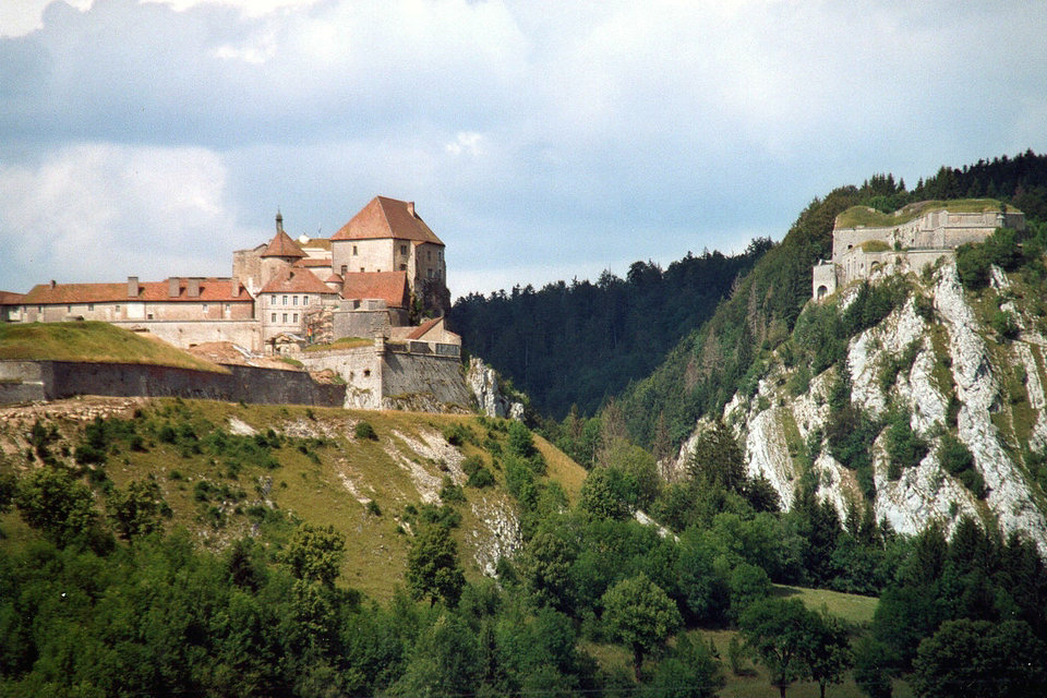
The massif presents historical sites such as the abbey of Saint-Claude, the Palladian villa, the castle of Joux and the abbey of Romainmôtier. An important industrial heritage is also present through many museums such as the toy museum of Moirans-en-Montagne, the museum of automatons and music boxes of Sainte-Croix or the international watch museum of La Chaux-de -Funds.
Environmental education
Since the hatching of the “animation” egg in 2007, the environmental education chick has grown. Nurtured first by the technicians who took this awareness-raising mission to heart, the educational program became so popular that the Nature Reserve team had to call on other service providers to provide all of the activities.
Today, the manager of the Nature Reserve, the Agglomeration Community of the Pays de Gex, has created an education service for sustainable development (ESD) to take charge of these school activities. Led by a small team of passionate nature and with varied skills, the educational content continues to expand, to best adapt to the expectations of schoolchildren and the general public while keeping in mind the message of the Nature Reserve national: that everyone feels concerned and an actor in this protected territory with incredible but fragile riches.