Victorville is a city in Victor Valley in San Bernardino County, California. Located in Southern California at the high-point between Los Angeles and Las Vegas, Victorville is the leading city for both industry and retail in the High Desert region. Victorville, California is best known as a stop along the famed Route 66 within its Old Town Victorville historic district.
Victorville is a growing, vibrant community that is home to approximately 135,000 residents and some of the area’s largest employers. Victorville is also known by its clean air, abundant mountain vistas, family-friendly recreational activities, spectacular sunsets and breathtaking night skies.
Victorville Located nearly 100 miles (160 km) northeast of Los Angeles, it lies along the Mojave River in the Victor Valley at the edge of the Mojave Desert, just north of the San Bernardino Mountains. It is conveniently located approximately 90 minutes from Los Angeles and just over two hours from San Diego. Victorville is within a few hours of SoCal beaches, National Parks, mountain retreats, and other major attractions; and Ontario International Airport is less than an hour away.
The settlement was founded in 1885 by the Santa Fe Railway. Originally named Victor for Jacob N. Victor, a railway official, the city changed its name (1901) because of confusion with the town of Victor, Colorado.
Mining (granite and limestone) and cement and lime production are the city’s basic economic activities, supplemented by agriculture (irrigated crops, poultry, and cattle), construction, and tourism. George Air Force Base, originally established in 1943, was decommissioned in 1992 and is now the Southern California Logistics Airport. Victorville and its backcountry have been used as settings for many western movies. A community college was established in the city in 1960.
Victorville residents and visitors to the city can take advantage of a wide variety of activities at nearby sites, including mountain skiing, water sports and access to the vast array of attractions in Southern California and the city of Las Vegas.
Victorville boasts the California Route 66 Museum, a repository of artifacts and photographs chronicling the history of the storied national highway and the communities it served. Also in Victorville is the Fire Museum, housing a collection of fire fighting equipment and memorabilia including exhibits dating from the 1930s which depict the history of the Victorville Fire Department.
A celebrated spring event in Victorville is the San Bernardino County Fair, a festival replete with carnival rides, celebrity concerts, livestock competitions and much more. Arts and entertainment can be found in the city’s Performing Arts Center, which offers a wide variety of concerts, plays and musicals. Sports fans can root for the High Desert Mavericks, a Class Triple-A minor league baseball team affiliated with Major League Baseball’s Seattle Mariners.
History
Victorville’s history dates back more than 100 years prior to incorporation, when the first settlers of European descent arrived. In about 1885, the community was known as Victor. It was named after Jacob Nash Victor, a construction superintendent for the California Southern Railroad (Santa Fe Railroad). The town was established as a result of the original railroad station constructed approximately one mile northwest of the narrows of the Mojave River.
On January 18, 1886, the Plan of the Town of Victor was prepared which created the grid pattern of the original town. This original subdivision included property between “A” Street through “G” Street and First Street through Eleventh Street. The area encompassed approximately 200 acres or one-third of a square mile.
The abundance of good water and the availability of rich bottom lands led to agricultural development shortly after the establishment of the railroad depot. Near the turn of the century, large deposits of limestone and granite were discovered. Since then the cement manufacturing industry has emerged as the single most important industry of the Victor Valley.
In 1926, U.S. Route 66 was established, which was one of the main arteries of the National Highway System linking Chicago, Illinois, with California. A portion of this famous highway provided a transportation corridor through Victorville, which was unsurpassed until Interstate 15 was constructed. Seventh Street and “D” Street were a part of this national highway.
During World War II, on July 23, 1941, initial construction of Victorville Army Airfield, later renamed George Air Force Base, began. The base was completed May 18, 1943. When fully activated, the base supported two Tactical Fighter Wings of the Tactical Air Command whose primary aircraft was the F-4 Phantom. It also employed approximately 6,000 civilian and military personnel.
Its land was turned over to other uses. Part of it is now the Southern California Logistics Airport. The former Air Force base housing area is now vacant. It forms a ghost town that is used for military training by troops from the U.S. Army’s Fort Irwin Military Reservation. The Victorville Federal Penitentiary has been built on another part of the former air base.
Victorville was incorporated on September 21, 1962 as a general law city. On January 5, 1989, the Secretary of Defense announced the closure of George Air Force Base under the Base Closure and Realignment Act. The base was deactivated December 15, 1992. The former military base was annexed into the City July 21, 1993, and has been renamed Southern California Logistics Airport.
In 2003, the Roy Rogers and Dale Evans Museum was moved from Victorville to Branson, Missouri. It closed before 2015. On November 3, 2007, Victorville hosted the DARPA Urban Challenge, a six-hour autonomous robot driving contest through the streets of the Southern California Logistics Airport. The $2 million first prize went to the Carnegie Mellon University team.
Main Attractions
There are several notable areas and locations within Victorville such as Spring Valley Lake, the Old Sheriff’s Office, U.S. Route 66, and the Victorville Film Archive.
A revitalization project started in 1995 in the ten square blocks along Historic Route 66. After years of setbacks in developing Old Town, the city, with input from residents and local business owners, created an Old Town Strategic Action Plan in 2007. In 2008, demolition of hazardous and dilapidated buildings began.
Projects include the Veteran’s Memorial on the corner of Seventh Street and Forrest Avenue, the Route 66 Museum, the Transportation Center, and the Old Victor School. Several large murals have been painted on the sides of buildings in Old Town.
Creative Arts Theater is the premiere production company in the High Desert Region. CAT has a large footprint in the community, offering acting classes for youth with a focus on the underprivileged, and scholarship opportunities.
Apple Valley was home to Roy Rogers and Dale Evans, whose museum was first established in Apple Valley (in 1967) before the museum was relocated to Victorville in 1976. In 2003, the museum moved again, to Branson, Missouri. The move was made in hopes of reaching more fans; however, the museum closed for financial reasons on December 12, 2009.
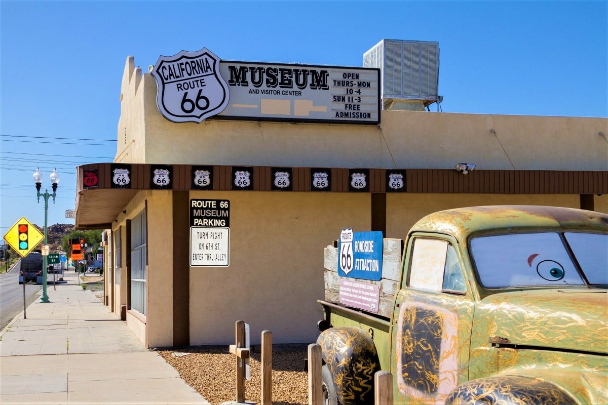
Route 66 Museum
The California Route 66 Museum, established in 1995 at the former Red Rooster Café building in Victorville, is one of two museums in the state devoted to the history of Route 66.A museum dedicated to the history and people of Victorville, this museum focuses on the westernmost portion of the historic highway.
Today, the building is home to more than 4,500 square feet of exhibits related to the historic route and to American automobile and roadside culture history, offering three unique display rooms of constantly-changing exhibits.
The museum provides information about Victorville’s history. This museum focuses primarily on the history of California Route 66, the famous road that runs through the Mojave Desert.This museum has many interesting things, such as old buildings, a restored motel, a gas station, and much more.
High Desert Center for the Arts
High Desert Center for the Arts is a theatrical performance venue in Victorville that was originally founded in 2010 as the Creative Arts Theater by Cherie and Tim Glisson. The theatre is an intimate space with two performance areas that allow patrons to enjoy performances by artists from around the United States. In addition to a variety of music concerts, film and dance performances are presented year-round at High Desert Center.
The High Desert Center for the Arts is a nonprofit community arts organization serving the greater Victorville and Adelanto communities of San Bernardino County, California. The Center offers year-round classes and workshops in a wide range of disciplines and presents live performances throughout the year in its 500-seat theatre.
The theater has presented a wide variety of musical and dramatic theatrical productions since its inception, including performances of classic favorites such as Grease, You’re a Good Man Charlie Brown, RENT, Into the Woods, and A Christmas Carol.
Area residents can audition for productions periodically, which are presented as part of the theater’s full season lineup and offer a number of public performances. An annual scholarship program at the theater also honors talented young actors within productions and provides financial assistance for further theatrical training. It also runs an artists’ residency program, which can work with established and emerging artists in various creative fields.
Mojave Narrows Regional Park
Mojave Narrows Regional Park is a regional campground and outdoor recreational area that is located along Horseshoe Lake, offering year-round opportunities to catch catfish, trout, and bass on its waters. Nearly 70 campsites and RV hookups are offered at the campground, including nine group camping sites available for overnight rental.
This small, 6.5-acre park is surrounded by an impressive natural wall of cliffs and hills. The park offers an abundance of wildflowers, especially during the spring when they are in bloom. There are also several wildlife species, such as mule deer and desert tortoise. The park has a trail system that allows you to hike or ride to different locations within the preserve. There is a small display of the area’s natural history, including fossils found in the cliffs.
All campsites offer restroom and shower use, dump stations, barbecue grills, and fire rings for visitors use. Several large group picnic shelters may also be rented for day use. Other amenities within the park include a children’s playground and zero-depth water play park, a disc golf course, and a number of walking, biking.
Scandia Family Fun Center
Scandia Family Fun Center is a unique Scandinavian-themed amusement park and family entertainment center in Victorville, offering seasonal rides and attractions for visitors of all ages. The Scandia Family Fun Center in Victorville, California, USA, is a large amusement park. It is the only amusement park of this size in the state and features a variety of rides, including coasters and other attractions such as bumper cars and go-carts. The park also boasts a miniature golf course and is home to many restaurants, a shopping center, and a large water park.
The Scandia amusement park chain was originally founded in 1977 and offers three locations throughout the California region, including locations in Sacramento and Ontario. Victorville’s location is home to rides such as a Crow’s Nest thrill ride, Baltic Sea Bumper Boats, and the Stockholm Raceway go-karting track. Visitors can enjoy a Scandinavian fantasy-themed miniature golf course and a full game arcade with video and redemption games. Eight fast-pitch baseball and softball batting cages are also available for play and rental.
On July 15, 2016, the park was scheduled to open its new expansion called “Scandia Family Fun Center 2”. The new park has four go-kart tracks, a bumper car area, a racing track, go-carts, a family coaster, and a couple of new fun rides.
Victorville Army Airfield auxiliary fields
Victorville Army Airfield auxiliary fields were four airfields used during World War II to support the Victorville Army Airfield pilot training near Victorville, California, and Adelanto, California. After the war the Victorville Army Airfield was renamed George Air Force Base on January 13, 1948. The airfields were built in 1941 by the United States Army Air Corps just before the war.
Victorville Army Airfield covered 2,200-acre in the Mojave Desert. The US Army held a groundbreaking ceremony on 12 July 1941. The base, called Victorville Army Flying School, was ready to use before the attack on Pearl Harbor on December 7, 1941. The Army built four runways in a triangle configuration, with one runway down the middle of the triangle. Seven hangars were built to support operation. On April 23, 1943, the base was renamed Victorville Army Airfield.
Holiday Skate Center
The Holiday Skate Center is a public indoor ice rink located in the San Bernardino County city of Victorville, California. A family-friendly roller skating rink and entertainment center in Victorville that is open to visitors of all ages. Holiday Skate Center has hosted a number of nationally ranked figure skating competitions. The facility includes a two-lane, deep ice surface with artificial lighting for night skating sessions.
Holiday Skate Center offers roller skating lessons throughout the week for children and adults, including group lessons on Saturday mornings and private instruction times available by appointment. The facility also hosts public skating sessions during the winter months and is available for rent by non-profit organizations during the summer months.
Green Tree Golf Course
Opened in October of 1963, Green Tree Golf Course in Victorville, California is a par-72, 18-hole course designed by William F. Bell. This public golf course provides an affordable game of golf for both residents and visitors alike in Victorville. Green Tree Golf Course consists of four different sets of tees designed for different levels of skill. The course features a 127 slope rating and the fairways and greens are blue grass.
The High Desert Farmers’ Market
The High Desert Farmers’ Market is located at the entrance to the Victor Valley Mall in Victorville, California. The market offers more than 60 vendors who provide various products, from organic produce and foodstuffs to arts and crafts. The High Desert Farmers’ Market is a state-certified farmers’ market in Victorville that was originally founded in July of 1992 by Victor Valley College student Kerri Santoro and professor Bob Adams.
The market strives to provide the Victorville region with fresh, affordable food, featuring meats, dairy products, produce, and pantry and specialty goods sold by local farmers and vendors. The market accepts SNAP, EBT, and WIC benefits in order to provide a consistent, affordable food source for lower-income residents in the region.
The market includes a number of vendors and exhibitors who sell their goods year-round, including the Desert Harvest Co-op, which offers an assortment of products grown by its members. In addition, the High Desert Farmers’ Market has grown into a staple of the community and provides an outlet for local residents to buy fresh and affordable produce. It is a member-owned and operated cooperative created to provide access to high-quality organically grown produce that is available throughout the year.
Retail Centers
Located in Southern California along Interstate 15, 90 miles northeast of Los Angeles, Victorville has successfully established itself among the most cost-effective locations in California to do business, providing its residents and the High Desert community an array of department, specialty, super market, warehouse, drug and discount stores at which to shop.
The Desert Plazas consists of a three-phased, planned 800,000 square foot retail development anchored by the Home Depot and WinCo Foods located at Roy Rogers and I-15.
Dunia Plaza, just south of the Mall of Victor Valley, features a Lowe’s Home Improvement, Kohl’s, Walmart, Michael’s Crafts, and Staples to name a few.
Restaurant Row is the High Desert’s premiere dining destination featuring 19 eateries including California’s first Cracker Barrel.
The Auto Park at Valley Center is the only auto mall in the entire Victor Valley. It provides an unparalleled variety of new and used cars and is conveniently located along Interstate 15 at the Roy Rogers exit.
The Crossroads @395, located on the west side of the City of Victorville, is one of the newest multi-tenant shopping centers recently developed. Retail tenants include Walmart, Walgreens, Dollar Tree and Sally Beauty to name a few.
The Mall of Victor Valley is the only regional mall located in the Victor Valley and has served the local consumer base since being built in 1985. The Mall of Victor Valley hosts Dick’s Sporting Goods, Macy’s, Barnes & Noble, Sears, and many other shops offering a wide range of apparel merchandise.
Filming location
Victorville has been used for commercial filming several times, the Mojave Desert city enjoys a cold desert climate year-round and has been used as a filming site for a number of major feature films, including Lethal Weapon, Face/Off, and Kill Bill: Volume 2. Some filming location of Victorville are list bellow:
3 Bad Men (1926), filmed northwest of Victorville and the surrounding desert; Passage to Marseille (1944), Victorville Army Air Field, later named George Air Force Base. It Came from Outer Space (1953), filmed in Victorville and the surrounding desert; Victorville served as the setting for the fictional town of “Sand Rock, Arizona”. Grand Theft Auto (1977), starring Ron Howard filmed in Downtown Victorville. The Hills Have Eyes (1977) by Wes Craven The Hitcher (1986), starring Rutger Hauer, C. Thomas Howell, and Jennifer Jason Leigh, was filmed at the Outpost truck stop. Many local residents were used as extras. Lethal Weapon (1987) was filmed at El Mirage Dry Lake west of Victorville.
From Dusk till Dawn (1996), the restaurant scene early in the movie Face/Off (1997), portions filmed at Southern California Logistics Airport in Victorville Breakdown (1997) starring Kurt Russell, filmed in downtown Victorville Contact (1997), also partially filmed in Victorville, with some local residents used as extras. Play It to the Bone (1999) filmed partly in The New Reflections concert venue in Downtown Kill Bill: Volume 2 (2004) was filmed in The New Reflections as well The Fast and the Furious: Tokyo Drift (2006) was partially filmed in Victorville. Sky (2015) included a dinner scene filmed in Emma Jean’s Holland Burger Cafe in Victorville.
Surrounding
SoCal beaches, mountain retreats, and National Parks are within a few hours of Victorville.
Big Bear Lake is Southern California’s four-season mountain lake escape. Located in the heart of Southern California – and an easy drive from Phoenix and Las Vegas. Big Bear Lake is the jewel of the San Bernardino National Forest and known for excellent fishing, snowboarding and skiing, hiking, mountain biking.
Lake Arrowhead is an artificial lake located in the San Bernardino Mountains on Little Bear Creek, a tributary of Deep Creek and the Mojave River. The lake was originally intended to serve as part of a major waterworks project to provide irrigation water to the San Bernardino Valley, and construction of the Lake Arrowhead Dam began toward that end in 1904.
Huntington Beach is a seaside city in Orange County in Southern California, located 35 miles (56 km) southeast of Downtown Los Angeles. Huntington Beach is known for its long 9.5-mile (15.3 km) stretch of sandy beach, mild climate, excellent surfing, and beach culture. The ocean waves are enhanced by a natural effect caused by the edge-diffraction of open ocean swells around Santa Catalina Island. Swells generated predominantly from the North Pacific in winter and from a combination of Southern Hemisphere storms and hurricanes in the summer focus on Huntington Beach, creating consistent surf all year long, hence the nickname “Surf City”.
Canyon, formerly known as Sequoya, the community is mainly traversed by Pinehurst Road and Canyon Road. The homes of the community are nestled amongst the steep, narrow private roads and footpaths that extend from the redwood groves and ferns along the creek, through the mixed live oak, bay, and madrone forests on the steep hillsides, up to the chaparral and knobcone pines that grow along the ridge.