Urban sprawl trends

Urban sprawl or suburban sprawl describes the expansion of human populations away from central urban areas into low-density, monofunctional and usually car-dependent communities, in a process called suburbanization.
Urban planners emphasize the qualitative aspects of expansion such as the lack of transportation options and the safety and tranquility of these neighborhoods. Its detractors, on the other hand, tend to focus on the actual amount of land that has been urbanized by the expansion.
The process of urban dispersion has, in general, negative connotations due to the damage to health and environmental issues that the expansion creates. Residents of expanding neighborhoods tend to emit more pollution per person and suffer more fatal traffic accidents. Dispersion is controversial, with advocates claiming that consumers prefer the lower density of neighborhoods and that expansion does not necessarily increase traffic. Dispersion is also linked to the increase in obesity since walking and riding a bicycle are not viable options for moving to the center of the city. Dispersal has a negative impact on the land and the quantity and quality of water and may be linked to a decrease in social capital.
Causes
Was promoted significantly and urban sprawl the landscape due to high price of land in cities, by the local urban land (on the edge of the settlements) and the solidification of splitter settlements in the outer region. Rising incomes are driving especially young families to realize the dream of owning a home in the countryside, without having to give up the job in the city. But also wealthy pensioners are moving into the suburban zones. The spread of the car makes the spatial separation of work and sleeping space more attractive and allows the settlement of companies outside the city limits. The state favoring the separation of work and residence by theDistance allowance and undifferentiated housing promotion are mentioned as causal and promoting urban sprawl. Likewise, the establishment of industrial parks and large shopping centers on the outskirts of the settlement areas promotes urban sprawl; it is founded with the creation of jobs and income for the communities.
In rural areas, in the villages, urban sprawl is favored by the conversion of farmland into building land, despite the fact that there is still land available in the core area. The design of the open-plan settlements has an additional impact on landscape consumption.
Traffic problem
Sprawl is also criticized for its traffic-producing effect. Public transport requires high population density and density of use in order to operate profitably. Residents of outlying districts are reliant on motor vehicles because of declining supply and declining demand for public transport. Some measures designed to reduce the negative symptoms of sprawl, eg. As park-and-ride, can make even more attractive and even accelerate this. Also controversial is the concept of the supply of existing demand that is widespread in transport policybecause road construction in many cases leads to new demand.
Social problem
One of the most controversial consequences of urban sprawl is its negative impact on social structure and quality of life. As low population densities and satellite towns are often unable to provide a wide range of services, public institutions such as libraries, swimming pools, secondary schools or day care centers are often lacking. The inhabitants are forced to travel long distances for most activities. It comes to the exclusion of residents who are unable to do so. Affected are above all minors, the disabled, older or socially weak people.
The situation is often aggravated by the fact that the street, which also functions as a kind of platform for public coexistence in the urban environment, degenerates into a mere transport artery in the urban sprawl and rather acts as an additional barrier. The high dependency on the car endangers the health of the population, since motorists travel fewer distances on foot or by bicycle and thus more frequently have a lack of exercise and the general concentration of pollutants in the air by many car drivers is much higher than by using public transport. Loss of purchasing powerUrban main streets in shopping malls can also lead to desertification of the cityscape and loss of diversity. Urban areas, formerly made up of a mixture of social strata, are experiencing increasing segregation (also simplifying ghettoisation) through the emigration of wealthier inhabitants into the bacon belt, which may exacerbate social tensions. But the formation of suburban ghettos, as observed especially in France, can also be a consequence.
Features
The dispersion is characterized by several land use patterns that are generally produced in unison:
Occupation of the ground with a low density of use
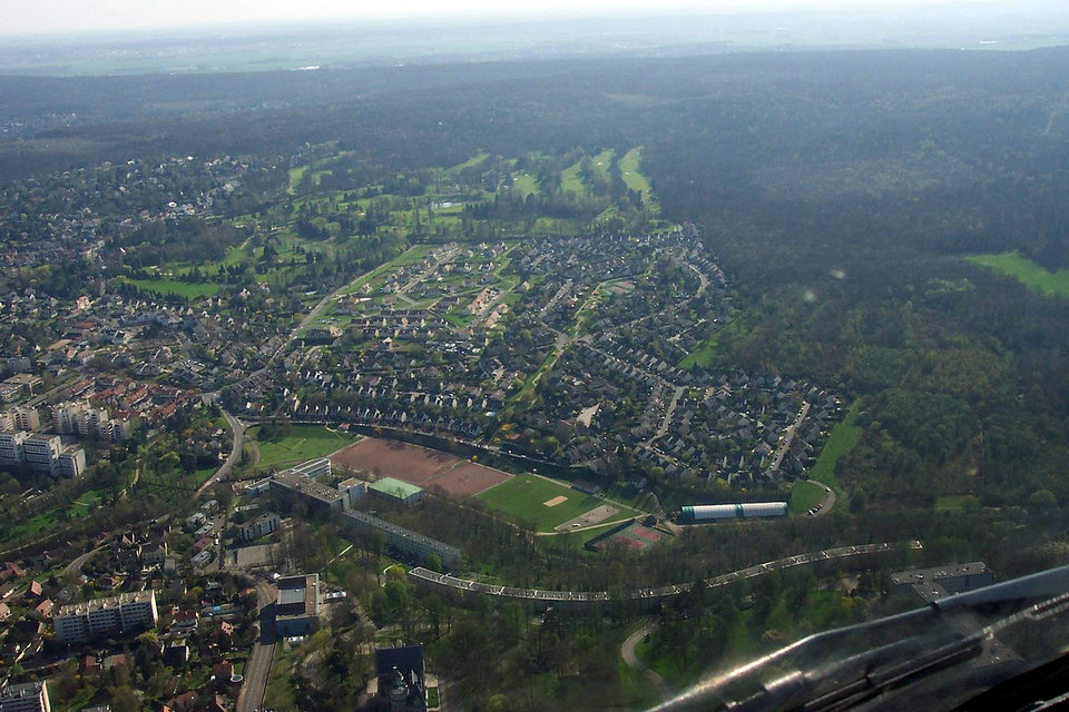
The dispersion consumes much more land than other types of traditional urbanization, because it points to a low density image. The exact definition of “low density” is debatable, but a common example is that of individual dwellings, as opposed to apartments or apartments. The buildings usually have a lower number of levels and are more spaced from each other, separated by gardens, roads or parking lots. These types of developments are much larger because they require large parking areas for the cars that are used. The greatest impact they produce in many communities is that they developed or “urbanized” at a faster rate than population growth.
Another common characteristic refers to the division, or its absence of division, between an urbanization and its neighbor. These are usually separated by large green areas, that is, extensions of idle land, resulting in a much lower average density even than the low density described above. This is due to the custom of requiring the developer of the subdivision to provide the infrastructure as a condition of development. Generally, the developer is required to reserve a certain percentage of the land for public use, including roads, parks and schools. When a municipalityit builds all the streets in a certain place, the city can be expanded without interruption and with a coherent circulation system, because it has the faculty of expropriation. Private developers, in general, do not have that power (although sometimes they can count on local governments willing to help), and often choose to develop on private land to sell homes and / or plots at the time that one wants to build, instead of paying more or wait for a more appropriate location.
Car dependence
The areas of urban dispersion are also characterized by being highly dependent on the use of the automobile as a means of transport. Most activities, such as shopping and transportation to the workplace, require the use of a car as a result of both the isolation and distance to the city center and the isolation of the residential area with industrial zones and commercial zones. Walking and other methods of mobilization are not practical, therefore, many of these areas have few or no sidewalks.
Special forms and trends
Gated communities
A special form of this development towards ghettoization is the increasing number of so-called closed housing complexes (eg country clubs, gated communities), especially in the USA, Great Britain and some developing countries, but also in other European countries. These “private quarters” are in many cases built in scenic areas, have high land use due to their large plots, and promote segregation by social class. In the cities of Britain, especially in London, there are these controversial closed housing developments in neglected neighborhoods that are close to the attractive financial district, but at the same time have a high crime rate.
Ruralization
The development of telecommunications infrastructure and the Internet has led to a new paradoxical development trend since the 1990s. As rural areas become more integrated into the communications environment, urban jobs are being shifted (“urbanization of the country” by “tele-villages” or outsourced city centers with call centers, etc.), decoupling many of the city’s economic dynamics and losing their infrastructure and infrastructure their urban quality. Unemployment and inadequate wages lead to “Urban Agriculture”. For example, in the form of urban vegetable farming on barren land, small animal husbandry on the balcony or fish farming on the roof (so-called ” urbanization of the city”). So come inHavana 90 percent of all fresh produce from inner-city gardens.
Industrial
On the other hand, by official decision, “urban” neighborhoods that have no urban qualities from the beginning and force the inhabitants to self-sufficiency as once in the Prussian industrial villages Altenessen, Borbeck, Schalke, Sterkrade or in today’s Chinese industrial villages with residential towers, industrial plants and extreme growth rates of the population (“Urban Villages”). The number of urban villagers – as the inhabitants of such areas are called – is estimated in China at 50 to 100 million.
Debate
According to Nancy Chin, a large number of effects of sprawl have been discussed in the academic literature in some detail; however, the most contentious issues can be reduced “to an older set of arguments, between those advocating a planning approach and those advocating the efficiency of the market.” Those who criticize sprawl tend to argue that sprawl creates more problems than it solves and should be more heavily regulated, while proponents argue that markets are producing the economically most efficient settlements possible in most situations, even if problems may exist. However, some market oriented commentators believe that the current patterns of sprawl are in fact the result of distortions of the free market. Chin cautions that there is a lack of “reliable empirical evidence to support the arguments made either for or against sprawl.” She mentions that the lack of a common definition, the need for more quantitative measures “a broader view both in time and space, and greater comparison with alternative urban forms” would be necessary to draw firmer conclusions and conduct more fruitful debates.
Arguments opposing urban sprawl include concrete effects such as health and environmental issues as well as abstract consequences including neighborhood vitality. American public policy analyst Randal O’Toole of the Cato Institute, a libertarian think tank, has argued that sprawl, thanks to the automobile, gave rise to affordable suburban neighborhoods for middle class and lower class individuals, including non-whites. He notes that efforts to combat sprawl often result in subsidizing development in wealthier and whiter neighborhoods while condemning and demolishing poorer minority neighborhoods.
Groups that oppose sprawl
The American Institute of Architects and the American Planning Association recommend against sprawl and instead endorses smart, mixed-use development, including buildings in close proximity to one another that cut down on automobile use, save energy, and promote walkable, healthy, well-designed neighborhoods. The Sierra Club, the San Francisco Bay Area’s Greenbelt Alliance, 1000 Friends of Oregon and counterpart organizations nationwide, and other environmental organizations oppose sprawl and support investment in existing communities. NumbersUSA, a national organization advocating immigration reduction, also opposes urban sprawl, and its executive director, Roy Beck, specializes in the study of this issue.
Consumer preference
One of the primary debates around suburban sprawl is the extent to which sprawl is the result of consumer preference. Some, such as Peter Gordon, a professor of planning and economics at the University of Southern California’s School of Urban Planning and Development, argue that most households have shown a clear preference for low-density living and that this is a fact that should not be ignored by planners. Gordon and his frequent collaborator, Harry Richardson have argued that “The principle of consumer sovereignty has played a powerful role in the increase in America’s wealth and in the welfare of its citizens. Producers (including developers) have responded rapidly to households’ demands. It is a giant step backward to interfere with this effective process unless the benefits of intervention substantially exceed its cost.” They argue that sprawl generates enough benefits for consumers that they continue to choose it as a form of development over alternative forms, as demonstrated by the continued focus on sprawl type developments by most developers. However, other academics such as Reid Ewing argue that while a large segment of people prefer suburban living that does not mean that sprawl itself is preferred by consumers, and that a large variety of suburban environments satisfy consumer demand, including areas that mitigate the worst effects of sprawl. Others, for example Kenneth T. Jackson have argued that since low-density housing is often (notably in the U.S.A.) subsidized in a variety of ways, consumers’ professed preferences for this type of living may be over-stated.
Automobile dependency
Whether urban sprawl does increase problems of automobile dependency and whether conversely, policies of smart growth can reduce them have been fiercely contested issues over several decades. An influential study in 1989 by Peter Newman and Jeff Kenworthy compared 32 cities across North America, Australia, Europe and Asia. The study has been criticised for its methodology but the main finding that denser cities, particularly in Asia, have lower car use than sprawling cities, particularly in North America, has been largely accepted although the relationship is clearer at the extremes across continents than it is within countries where conditions are more similar.
Within cities, studies from across many countries (mainly in the developed world) have shown that denser urban areas with greater mixture of land use and better public transport tend to have lower car use than less dense suburban and ex-urban residential areas. This usually holds true even after controlling for socio-economic factors such as differences in household composition and income. This does not necessarily imply that suburban sprawl causes high car use, however. One confounding factor, which has been the subject of many studies, is residential self-selection: people who prefer to drive tend to move towards low density suburbs, whereas people who prefer to walk, cycle or use transit tend to move towards higher density urban areas, better served by public transport. Some studies have found that, when self-selection is controlled for, the built environment has no significant effect on travel behaviour. More recent studies using more sophisticated methodologies have generally refuted these findings: density, land use and public transport accessibility can influence travel behaviour, although social and economic factors, particularly household income, usually exert a stronger influence.
Those not opposed to low density development argue that traffic intensities tend to be less, traffic speeds faster and, as a result, ambient air pollution is lower. (See demographia’s report.) Kansas City, Missouri is often cited as an example of ideal low-density development, with congestion below the mean and home prices below comparable Midwestern cities. Wendell Cox and Randal O’Toole are leading figures supporting lower density development.
Longitudinal (time-lapse) studies of commute times in major metropolitan areas in the United States have shown that commute times decreased for the period 1969 to 1995 even though the geographic size of the city increased. Other studies suggest, however, that possible personal benefits from commute time savings have been at the expense of environmental costs in the form of longer average commute distances, rising vehicles-miles-traveled (VMT) per worker, and despite road expansions, worsening traffic congestion
Paradox of intensification
Reviewing the evidence on urban intensification, smart growth and their effects on travel behaviour Melia et al. (2011) found support for the arguments of both supporters and opponents of smart growth measures to counteract urban sprawl. Planning policies that increase population densities in urban areas do tend to reduce car use, but the effect is a weak one, so doubling the population density of a particular area will not halve the frequency or distance of car use.
These findings led them to propose the paradox of intensification, which states:
Ceteris paribus, urban intensification which increases population density will reduce per capita car use, with benefits to the global environment, but will also increase concentrations of motor traffic, worsening the local environment in those locations where it occurs.
Risk of increased housing prices
There is also some concern that anti-sprawl policies will increase housing prices. Some research suggests Oregon has had the largest housing affordability loss in the nation, but other research shows that Portland’s price increases are comparable to other Western cities.
In Australia, it is claimed by some that housing affordability has hit “crisis levels” due to “urban consolidation” policies implemented by state governments. In Sydney, the ratio of the price of a house relative to income is 9:1. The issue has at times been debated between the major political parties.
Proposed alternatives
Many critics concede that sprawl produces some negative externalities; however there is some dispute about the most effective way to reduce these negative effects. Gordon & Richardson for example argue that the costs of building new public transit is disproportionate to the actual environmental or economic benefits, that land use restrictions will increase the cost of housing and restrict economic opportunity, that infill possibilities are too limited to make a major difference to the structure of American cities, and that the government would need to coerce most people to live in a way that they do not want to in order to substantially change the impact of sprawl. They argue that the property market should be deregulated to allow different people to live as they wish, while providing a framework of market based fees (such as emission fees, congestion charging or road pricing) to mitigate many of the problems associated with sprawl such as congestion and increased pollution.
Alternatives
Attempting to mitigate urban sprawl and its consequences, urban planning and transport strategies have emerged in recent decades aimed at concentrating the growth of the city in its central area, densifying it, establishing mixed land uses and developing transport systems and networks. that discourage the use of the automobile.
The first city to put limits on the growth of urban sprawl in the United States was Lexington in 1958. Fifteen years later, the state of Oregon enacted a law in 1973 that defined the areas where these ventures could be established. As a result, the city of Portland has become a pioneer in the so-called smart growth, establishing consolidation policies for urban areas. While the growth limit has not been tightened enough to dramatically increase density, it ensured the protection of large amounts of wild areas and agricultural lands throughout the metropolitan area.
In other areas, urban design with New Urbanism principles and New Pedestrianism has been employed to combat urban sprawl.
Effects on landscape naturalness and ecosystem services
Periurbanisation contributes to the destruction of environments and to the ecological fragmentation of landscapes and the night environment (because of the public lighting that accompanies housing developments). The spread of housing estates, commercial and energy spaces at the edges of natural or protected areas, often threaten their integrity and encourage the introduction of new species (potentially susceptible to becoming invasive).
In North America, the early 2000s, the road network takes up about 1% percent of the land surface but it is estimated that “alters” directly ecological structures and functions of 22% of the space. “Where peri-urbanization is fast, species richness and endemism are decreasing as urban coverage increases, threatening biodiversity”. The habitat fragmentation threat of extinction at least 500 species in the United States. “It also provides new entry points for invasive species already introduced by other means”
The construction of subdivisions and houses on the edge of fire-prone forests and grasslands is a factor in the rise in the number of accidental fires in the United States (Hermansen 2003, CFS 2004). Fire and drainage then favor pathogenic alien tree species at increasing cost (CFS 2004).
For example, in the United States in 2000, urban and suburban facilities covered approximately 126,000 km2 and exurban housing occupied seven times more space (11.8% of all US land). The most affected areas (early 2000s) are the rural areas of the Rocky Mountains, the southern states and California. In the United States still, the increasing spread of urban belts increases forest fragmentation, and the disappearance of forests and grasslands as well as agricultural soils, wetlands and other resources such as natural habitats and biodiversity; out of 36,400 km2 constructed between 1997 and 2001, 20% were previously agricultural land, 46% forest and 16% pastureland (NRCS 2003). Urban sprawl is another threat to the large grassland in central North America, once immense and, in two centuries, “one of the most threatened ecosystems, both continentally and globally. worldwide »; Nearly 50% of the decline of grassland from 1982 to 1997 in the US is due to urban development.
Waterproofing and urban runoff are sources of pollution transfer and less replenishment of groundwater (Marsalek et al., 2002). The Rurban population imports off-road vehicles whose tracks also contribute to the ecological fragmentation of the environment, the aggravation of erosion and disturbance (especially noise pollution) and air pollution, particularly in the United States. United.
Peri-urban areas are more exposed to certain health risks (eg Lyme disease and others carried by ticks whose populations are expanding).
An obstacle to sustainable development
According to the French Environment Institute (IFEN), 60 000 hectares of natural or agricultural land are lost every year in France due to urbanization. Artificial surfaces (roads, buildings, car parks, etc.) increase three times faster than the population (in France, the population increased by 8% from 1982 to 1999, artificial surfaces by 42%). In some regions, artificial surfaces even doubled during the same period (in the case of Pas-de-Calais, with an increase of 95% in artificial surfaces for growth of a few points of the population).
By artificialising more and more soils (roads, larger individual dwellings…), there are more and more agricultural, forest, pastoral or natural spaces that disappear, and with them their fauna and flora. In biologist jargon, the biotope disappearing, the associated biocenosis disappears, and as a consequence, the ecosystem no longer exists.
In addition to fauna and flora, artificial soils impede the infiltration of rainwater and promote runoff, which is a factor of erosion on land – cultivated or non – terraced. Urban sprawl may result in the rarefaction – or even the disappearance – of certain animal species (such as the Hermann tortoise or certain frogs) or plants. The fragmentation of the natural habitat, which can be a barrier to gene flow between different populations of the same species, can thus be at the origin of a reduction of the genetic diversity.
Moreover, the energy cost of this type of development is high, because of the increase in the displacements it induces and the greater difficulty in heating and thermally isolating the low-density buildings that accompany the urban sprawl.
Urban sprawl is often linked to the functional specialization of spaces (separation on the territory of the functions of housing, employment and service) and to spatial segregation (gentrification of the city center, peri – urbanization of the middle classes and ghettoisation). poorer classes). The combination of these phenomena is highly generating greenhouse gas emissions, in particular because it has the effect of increasing local mobility (achieved within a radius of 80 km around the home). These evolutions also lead to an increase in the vulnerability of territories to climate change via the weakening of biodiversity and the reduction of agricultural areas, even though their preservation is essential to maintain adaptability, or through increased risks. flooding by artificialisation of soils.
The sustainable development is thus hardly compatible with the constraints of suburban in terms of travel and space consumption and the pollution it brings. However, solutions have been envisaged and sometimes implemented, such as in Grenoble with the Bonnes Eco neighborhood, which induces a mix of activities in the neighborhood limiting travel and a densification of it reducing the consumption of space seeks to meet the needs of sustainable development.
An effect on rural
Almost everywhere in the world, on the outskirts of cities, the rural population tends to be replaced by “rurban”. For example, in Canada, urban sprawl was the major cause of the increase in the rural population from 1991 to 1996, particularly in the West . In the United States, from 1990 to 2000, the “exurban” population of the 22 states west of the Mississippi River increased by 17.3 percent (Conner et al., 2001). Population growth in the Central Valley of California, which supplies a quarter of the country’s food, now threatens farmland
In France, the FNSAFER warned on 24 May 2007 that “rural areas are still considered as the reservoir of urban extension”. Ten years later Ademe (Environment and Energy Management Agency) considers that “urban sprawl still consumes 54,000 hectares of land, mostly agricultural, every year”
The presentation of the new zoning of INSEE in October 2011, in which the “predominantly rural area” disappears was considered by some to be the symbolic proof of the death of “rurality”, in connection with urban sprawl. First, the ruralization of rural areas brings about a change in the residential functions of rural communities, which are losing their agricultural aspects. Suburbanization is also accompanied by the installation of equipment and activities contributing to the urban system to the detriment of the rural world.
If urban sprawl entails a tension between the different visions of the territory of the rural and the new arrivals, this one is explained in particular by a misunderstanding of the city dwellers of the territorial coherence of the rural spaces. Subjected to periurban pressure, these spaces, with a social and economic coherence and a set of values attached to the rural world, are transformed by jerks. These transformations are therefore abrupt, depending on the spatial needs of a population from a completely different economy, that of the city. The plot of the villas or place names remain the same time that the landscape and customs is dénaturalisent.
Urban sprawl and tourism
On October 15, 2007, the French Institute of the Environment (Ifen) indicated that between 1990 and 2000, three times more land had been “artificialized” in the coastal municipalities than in the average of the country, especially in the area. between 500 meters and 2,000 meters from the coast. Ifen added that housing construction has more than doubled since 1990.
This artificialisation of the littoral lands is disparate according to the regions of the littoral. Thus the North Sea coast is highly urbanized and artificialized due to a very strong specialization in maritime transport and associated activities. The Mediterranean coast is similarly so, but mainly because of tourism and the residential economy. The coasts coastal Breton are still relatively unspoilt by contrast although the artificial due to urban sprawl is beginning to affect. The tourism has resulted in the southern coastal areas has a strong urban sprawl to ensure the accommodation of tourists but their activities oriented commercial structure to meet the needs of tourists, urban development (waterfronts, malls, convention center…).
Urban sprawl and segregation
We can also wonder about the phenomenon of segregation of this mode of development and about the low social mix within a subdivision.
New housing estates are often built in a very short time and quickly populated with very similar homes: young couple with young children or planning to have one (few singles, seniors, couples without children). In fact, couples with children make up more than one third of households in all peri-urban and multipolarized communes in France.
However, as a consequence of many phenomena, including the evolution of family models, the cohabitation of young people or the aging of first-comers, today we are witnessing a change in the composition of households in the peri – urban area. If shares of retired households and single-parent families are lower than in urban centers, they increase gradually still.
Clearance vis-à-vis neighbors and public space is one of the characteristic elements in the spaces produced by urban sprawl. However, if the social links within the daily living space are less and less taken into account, reinforced by the widespread importance given to the axes, nodes and networks in relation to the neighborhood, a residential community is developing. It seems to respond to a desire to live between people sharing a set of common values and qualities. The suburban is for some authors place of research by the middle classes weakened a protective self-segregation, Framed by public and private regulatory constraints that contribute to segregation that grows without the need for isolation devices, although it is not as accomplished as in enclosed communities.
The gated communities are emerging increasingly in space suburban, generally within the urban front, there or urbanization has occurred most recently, notably the United States and Latin America.
Now if suburban area hosts closed spaces for the well-off, it is also seen by some authors as a relegation space for white working class forced from globalized metropolises. Moreover, in France, the vote National Front would be more pronounced in this space, which therefore would highlight the withdrawal already mentioned is claimed in the space peri. Many authors question this essentialization of the peri – urban space: “the peri-urban territories are too vast and too varied to be reduced to one vote” (E Charmes). Moreover, if the poverty rate in 2012 is 16.1% in the major French urban centers (city centers and suburbs), it is only 8.8% in their crowns.
Source from Wikipedia