UNESCO Geopark of Haute-Provence, Provence-Alpes-Côte d’Azur, France

The UNESCO Geopark of Haute-Provence is often referred to as the “geologists’ paradise”. Indeed, bearing the traces of more than 300 million years of history of the Earth, the ground here is blessed by geologists. Discover its unique geological heritage , its remarkable biodiversity , its culture made up of human stories and its contemporary art , life-size.
The Haute-Provence National Geological Nature Reserve (RNN73) is a national nature reserve located in the Provence-Alpes-Côte d’Azur region . Classified in 1984, it occupies an area of 269,316 hectares spread over 18 sites in Alpes-de-Haute-Provence and Var . Located between the Verdon and the Durance , it is a territory labeled for the diversity of its landscapes, witnesses of the geological past of this massif and of the Earth. It is the largest reserve of this type in Europe.
The UNESCO Geopark of Haute-Provence was born out of a desire to protect and preserve the geological heritage of the territory . Today it works to promote and animate all of the heritage of its territory. From geological forces to that of men, a particular history has developed which has shaped the identity of Haute-Provence over the millennia. In this story, the geological footprint is decisive. It is this special relationship between the land and the inhabitants that UNESCO Geopark of Haute-Provence wishes to share with as many people as possible.
Discover this territory starting with the Promenade Museum , in Digne-les-Bains, the museum interpretation center of the UNESCO Geopark of Haute-Provence. You will find in this place all the keys to understand the landscapes that surround you. After that, you will be self-sufficient to explore our five discovery routes . They will take you through emblematic and heritage places of Haute Provence.
The Geopark
The UNESCO Geopark of Haute-Provence is deploying a project to promote the different heritages of the territory and propose sustainable territorial development strategies in partnership with the population. Promoting and allowing all audiences to discover the region’s many riches are the primary missions of UNESCO Geopark of Haute-Provence. It develops museographic content, equips the sites and offers discovery itineraries allowing to understand the very essence of this territory. In doing so, the Geopark encourages people to meet with associated partners. Finally, it offers mediation, awareness and education actions. For visitors, several entries are therefore possible.
The Promenade Museum, museum interpretation center . Perched on its tuff peak, the museum dominates Digne-les-Bains and offers a breathtaking view of the city. The public is welcomed in a shaded park, an oasis of greenery and freshness, where paths and streams rub shoulders with works by internationally renowned artists . Exhibition rooms retrace the tumultuous local geological history through a collection of fossils and tropical marine aquariums. The Promenade Museum is the privileged gateway to understanding the landscapes that surround us.
The UNESCO Geopark of Haute Provence also offers to discover the territory by discovery routes crossing the emblematic and heritage places of Haute-Provence. In total autonomy, with the specific Geopark card, visitors can explore the vast territory at their own pace according to different centers of interest.
Along the way, meet our : restaurateurs, artisans, producers or passionate hosts, each with stories to tell, know-how to share. Ask for Mandala Voyages, a team of travelers at heart, guides and guides. Taste delicious dishes at Marie’s café restaurant, La Beluguette, on the typical village square of Thoard , continue your way through the garden in Guilène saffron cultivation, to the village of Moustiers-Sainte-Marie, where you discover the traditional earthenware of the Bondil family, a know-how passed down from generation to generation. End your journey with the exceptional panorama over the town of Digne and its mountains at the top of the perched village of Vieil Aiglun, fully restored in lodgings by the Speth family.
A mediation service . Geologists and qualified animators welcome you and guide you to explore the vast riches of the territory. As a couple, as a family or in a group (professional, school or other) we adapt according to your needs and desires. Learn to read in the rocks and landscapes which surround us, to position oneself on the scale of the history of the earth and to glimpse our human appearance. Discover the life and customs of our ancestors in these reliefs. To be able to spot plants and animals, to know their uses, their benefits. Let yourself be surprised by a work of art inspired by these landscapes and question yourself. It is about sharing with you an entire ecosystem through a multifaceted reading, to let yourself be told the story of a country. Oforganized discovery offers are offered at the Promenade Museum and on the UNESCO Geopark territory.
The actions carried out by UNESCO Geopark of Haute-Provence aim to encourage genuine sustainable and reasoned local dynamics . For this, actors (producers, hosts, professionals in outdoor activities) engage in a partnership with UNESCO Geopark of Haute-Provence in order to jointly raise the overall quality of the offer in our territory. It is also about promoting the link between all these local players. Working in collaboration allows for a coherent global action in a prospective vision of the territory .
Geological heritage
For decades, generations of geologists from all over the world have surveyed our region. On the threshold of the Alps and Provence, this fabulous land reveals in a short distance more than 300 million years. The tumultuous geological history of this region is at the origin of its reliefs and grandiose panoramas such as that of the Velodrome , where the successive layers evoke a past that is always difficult to put into perspective on the scale of human time. From the Serre d’Esclangon (1152 meters above sea level), we discover this gigantic fold in the heart of which a blade of rock soars skyward: the Blade mountain of Facibelle .
130 million years ago, giant ammonites growing over more than a meter had colonized the ocean which then covered this region of the Prealps. Examining the immense 320m2 slab covered with more than 1,500 fossilized ammonites and nautiluses. This slab is a precious witness to the seabed from 200 million years ago. For millions of years, the sea covered the region. By withdrawing under the effect of the uplifting of the Alps, it brought out geological treasures such as the lunar desert of the Black Lands or the strange sea monsters that are the ichthyosaurs . Then the rivers and torrents dug the rock until they carved splendid clues whose autumn colors revive the power. One can quote the clue of Sisteron , the clue of Péouré or the clue of Barles .
Geological history
The UNESCO Geopark of Haute-Provence stretches in the Southern Alps from Lake Sainte-Croix on the Verdon to that of Serre-Ponçon on the Durance. The Tete de l’Estrop only needs 40 meters to enter the “3000” club and yet this country has been for hundreds of millions of years under the sea. It is the collision of the African plate with the European which gave birth to the chain of the Alps where we find ourselves today.
The seas of the Jurassic and Cretaceous which gradually deepen in very varied environments and abound with life with ammonites , belemnites, ichthyosaurs , fish. A large part of the sediments that gave rise to the rocks of our mountains are deposited there. The pools are gradually filling up. The Tertiary (or Cenozoic) Era is the period when Alpine mountains are formed. The sea occupies different areas before withdrawing definitively, the sediments that are deposited there are quite different from the previous ones. It is also deposited in lakes or rivers which have an important place in the landscape. In the Quaternary, the Haute-Provence Geopark emerged and glaciers descend from the Alps into our valleys. Since their withdrawal 15,000 years ago, Man has been shaping and modifying this territory.
The Primary Era
The Carboniferous lands were deposited around 300 million years ago at a time when our region was covered with forests of tree ferns, giant horsetails and the ancestors of today’s conifers. They lived in a hot and humid climate of the equatorial type. Analysis of the rocks shows a swampy floodplain environment. Quickly and regularly buried in the sediments, plant debris is the cause of the formation of coal layers.
No trace on the other hand of deposits from the following period, the Permian (-298, -252ma), which ends the Primary Era. It is likely that our region then formed a relief (within the Hercynian mountain range) subject to erosion where there were no deposits (a bit like today). Besides the greatest mass extinction within the living world, the end of the Primary Era was also marked by climate change and the erosion of the Hercynian mountain range.
The Triassic
In the Triassic, the single super-continent called Pangea gradually fragmented into two sets separated by a marine space: the Tethys Ocean settled between Laurasia in the north and Gondwana in the south. Our region is located on the southern margin of Laurasia. The lands of the Lower Triassic are rather rare in our territory, it is especially the quartzites of the Clue de Verdaches which represent ancient sands and quartz gravels carried by rivers.
Subsequently, the most abundant and spectacular rocks are brightly colored and variegated argillites which are often associated with large deposits of gypsum . The gypsum is deposited in an environment of lagoons in a hot and arid climate, it is an evaporite like salt and anhydrite which often accompany it. Gypsum plays an important role in the structuring of the Alpine chain by facilitating the movements of large rock panels thanks to its high plasticity. It is called a soap diaper. Gypsum is also a traditional raw material which has contributed to the originality of old buildings. Every village that could once baked its plaster for local needs.
The Lower Jurassic
In Lias, the marine space deepens and expands through the play of oceanic expansion; our region is frankly under water. The underwater topography is rugged by the interplay of faults which offset large panels from the earth’s crust. The sediments which are then deposited are modulated by this topography. They became limestones, marls or marl-limestones depending on the depth, the agitation and the distance from the shore. On our territory there are big differences between the south of Provençal affinities where the deposits are more coastal and less thick and the north of Dauphinoise affinities where the deposits are more pelagic (facing the open sea) and thicker. The sea is teeming with life and fossils abound. It is from this period that some of the most emblematic sites of the Geopark date: the ammonite slab , the ichthyosaur of La Robine , the turnstiles of Astoin , etc.
The Middle and Upper Jurassic
In Lias, the marine space deepens and expands through the play of oceanic expansion; our region is frankly under water. In the middle and upper Jurassic, the sea is still very present and still widens. It experiences variations in its depth, due to fluctuations on a global scale. The rocks resulting from the sediments deposited at this time are very characteristic in the landscape. Above the cornice formed by the marl-limestone alternations of the Bajocien -Bathonien stretch the imposing Black Lands , known for their lunar landscapes. They are surmounted by the cliffs of Tithonian limestone which closes the Jurassic and overflows a little into the Cretaceous.
This thick limestone ensemble is an easily identifiable landmark. It arms a large part of the reliefs: barre des Dourbes, mountain of Gache, ridge of Reynier … It constitutes the majority of the clues (or gorges) found in the Geopark: Clues de Barles , Clues de Chabrières, Clue de bayons or from Sisteron
The Cretaceous
The sea still covers the territory of the future Geopark. It first deposits marls and limestones (in Barrémien for example) with beautiful ammonite faunas. Then come thick layers of black marl like those which yielded the ichthyosaur of Chanolles . During the latter part of this period, very thick layers of clear limestone are deposited testifying to a decrease in the depth of the sea.
The Cretaceous is also the period when the formation of the Alps begins. Around 80 million years ago, the movement of the tectonic plates changes, the opening and widening of the Atlantic pushes Africa towards the northeast which will lead to the formation of the chain of the Alps and those that border the Mediterranean. The first elongated east-west folds appear: the Luberon and Lure chains…. The first land surfaces undergo erosion from hot climates.
Tertiary Era
At the beginning of the Tertiary, the whole Geopark emerged because the movements started in the Cretaceous continued. The layers deposited during the Secondary Era were warped, wrinkled, piled on top of each other and rose out of the waters. They are already subject to erosion. In the Eocene the northeast edge of the Geopark saw the sea return. Limestones, marls and sandstones are deposited. These sandstones are very abundant to the east of the Geopark, in Annot, but they also crown the Estrop massif. The rest of the territory hosts some continental formations. In the Oligocene then, the collision of Africa and Europe is accentuated in a rotational movement which combines the effects of compressions and extensions.
In our region, deposits called “red molasse” accumulate gravels, sands and clays brought by the rivers which descend from the young alpine reliefs subjected to the erosion of the tropical climate. In the Miocene, the formation of the Alps continued and reached its climax. The chain is surrounded by a shallow arm of the sea that runs from the shores of the present-day Mediterranean to Austria. Here, we observe a stack of fossil beaches hundreds of meters thick. There are various fossils, bird prints and even the rhythm of the reconstructed tides .
The End of the Tertiary and the Quaternary
In the second part of the Miocene then in the Pliocene and the Quaternary, the movements of the tectonic plates which built the Alps change and lead to the formation of the Mediterranean. The streams that drain the Geopark are now heading towards it. Its evolution influences erosion and sedimentation throughout the territory. When around -5 million years old, it dries up all the rivers start to dig narrow and deep gorges to catch up with the level. When it fills again, the sedimentation fills these canyons.
Two major features of the current landscape take shape at this time. On the one hand, the fault which has been running for tens of millions of years under the current Durance valley between the Mirabeau bridge and Sisteron delimits the western edge of a basin which receives the products of erosion carried by the Durance , Bléone, Asse… This is what we call the Valensole basin with its millions of pebbles and whose surface corresponds to the filling of this basin. On the other hand, a thick slice of land (nearly 2000 m thick) moves from north to south, guided by large faults of the same family as that of the Durance and thanks to the presence at its base gypsum, a soft, soluble rock which acts as a soap layer. It is the layer of Digne which constitutes the set of reliefs which surround the city and a large part of the reliefs of the Geopark.
Finally, the glaciers will leave their mark on the territory, especially that of the Durance and that of Ubaye, which overflow from the north onto our Geopark. We owe them the modeling of the Seyne basin, for example, and the abandonment of residual moraines and peat bogs after their departure. Further south, their influence on the sea level is reflected in the different stages in the digging of the valleys and the pebble terraces which underline them.
Geological Reserve
130 million years ago, giant ammonites growing over more than a meter had colonized the ocean which then covered this region of the Prealps. These fossils can be discovered, either at the museum of the Haute-Provence geological reserve , or in situ on geological sites with folded and fractured layers.
The most famous site is the ammonite slab , on the RD 900, 1.5 km north of Digne-les-Bains . Tilted at 60 °, it has around 1,500 ammonites , 90% of which are of the Coroniceras Multicostatum species dating from the Sinemurian ( Lower Jurassic ). These ammonites can reach a diameter of 70 cm . You can also see nautilus , belemnites , pectens and other bivalves . The thickness of the deposit is estimated at 20 cm, established over a period of approximately 100,000 years .
The Robine ichthyosaur, exhibited at the Digne museum, lived in the Upper Toarcian, around 185 million years ago. This marine reptile was buried very quickly which limited its decomposition. Its conservation is due to favorable paleogeographic conditions with the tilting of blocks linked to the rifting which accompanied the opening of the Liguro-Piedmontese Ocean.
In Castellane , the Maison Nature et Patrimoine museum takes you back in time 40 million years. A warm sea then covered this part of the Alpes de Haute-Provence and was populated by marine mammals, the sirenians . Also known as the sea cow, since they feed on algae and aquatic plants, they gave birth to the ancient myth of mermaids.
Biodiversity
Typically Provençal in the south and already alpine in the north, the meeting of the Mediterranean climate with the alpine mountain climate has favored, on the territory of the UNESCO Geopark, the blossoming of an astonishing biodiversity. Flora and fauna have gradually tamed this land preserved from urban and industrial pollution. This omnipresent and generous nature makes up a play of shapes and colors that is both soothing and rejuvenating for those who linger there. Here, we never tire of these landscapes which change with each season. Fill your lungs with this pure and intoxicating air. A moment of simple tranquility, free from all constraints.
In Digne-les-Bains for example, in the heart of the Geopark, more than 130 species of butterflies have been identified . You may be lucky enough to come across the Proserpine or the Isabelle de France , rare species present in particular in the Butterfly Garden of the Promenade Museum. Some high-altitude lawns are home to the Orsini viper : an endangered species, the subject of a national safeguard plan. It is part of the list of ten species of snakes discreetly present in the Geopark, knowing that the entire metropolitan national territory has only twelve!
On the limestone cliffs, spot a survivor of the last ice age, the Thuriferous Juniper . And there are also thyme, rosemary, savory, sage and lavender that perfume along the trails. On your way, refreshing waterways shelter a particularly developed aquatic fauna. Without forgetting the tufa waterfall of the Promenade Museum, nourishing the emergence of a plant world in its own right …
Higher in the sky, Griffon Vultures observe us, flying attentively over the mountainous areas, ensuring the cleaning of carrion. And at nightfall, a limitless space opens up to you: the celestial vault. Several UNESCO Geopark communes have received the mention of “Star Villages” such as Sigoyer, Mirabeau or Estoublon . Observing the starry sky is a real wonder for young and old. There is perhaps a good reason why Pierre Gassendi (1592-1655) famous mathematician, philosopher, theologian also became an astronomer. Indeed, legend has it that Pierre Gassendi, guarding his parents’ herds during the night on the heights of the village of Champtercier, became passionate about this extraordinary spectacle that the starry sky of Provence offers us every night.
Human activities
Architecture heritage
Since his appearance in the region, more than 400,000 years ago, man has moved around, adapting to the geography of the place. Despite difficult conditions, it settled permanently in the territory occupying valleys, reliefs and plains.
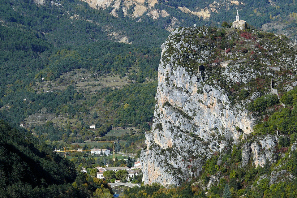
To protect themselves, the inhabitants have built villages perched on the peaks of the mountains, as in Thoard . Seen from the sky, this village with the strange shape of an almond which perfectly matches the relief on which it is placed. Elsewhere, man has also built fortresses with great ingenuity such as the Citadel of Sisteron or the Fort Vauban de Seyne . These ramparts against the enemy transformed the perspective of their village. Perched high or at the bottom of valleys, the villages are the soul of this territory with their alleys, squares and fountains but also their beautiful doors and their majestic bell towers . Estoublon , Courbons , Prads-Haute-Bléone , are very lively villages during the patronal festivals, an ideal time to taste local life and feel the Provençal art of living. Most often, this built heritage draws its character from local natural resources, such as plaster (extracted from gypsum ). Scattered throughout the area, lime kilns and plaster mills still bear witness to the work of transforming these local resources. Undeniably, geological history is at the origin of this so special soil.
The Ecomusée de La Javie perfectly retraces the daily life of the villages at the beginning of the last century. There is the reconstruction of a grocery store, a classroom or a kitchen. This evocation of the life of yesteryear is made possible thanks to the involvement of the inhabitants, who did not hesitate to search and remove all traces of this past life from their attic.
A land of culture but above all, a land of agricultural labor: orchards of fruit trees in the hollow of the Hautes-Terres-de-Provence valley, lavender fields as far as the eye can see on the Valensole plateau , fields of olive trees on the heights of Estoublon and sometimes truffle oaks . Through the resources he cultivates, man also maintains the soil. Likewise, the shepherd taking his sheep to graze on the heights during his annual transhumance.
Economic activities
In the hands of our producers, local products take on a special flavor. At Vieux Moulins , Marie-France Girard takes care of her olive trees all year round. And from the first frost, the harvest begins! The juicy olives are then transformed into a tasty oil. Nicolosi Création transforms lavender, a plant with many properties, into essential oil and cosmetic products. Etoile du Berger , for its part, continues the tradition of the candied Sarteau pear: a pear picked in orchards on very old trees, so hard that you cannot bite it without cooking it. Families have learned to cook this fruit to make jam, pear bread, fruit jellies… And every year, the Sarteau pear festival at La Javie, it’s time to taste all the ways to cook it.
This nourishing land also provides other raw materials for artisans. In Moustiers-Sainte-Marie for example, a village nestled against the mountain evoking Tuscany, you can discover all the talent of master eartheners like the Bondil family . Earthenware, the original material of which is clay, is a delicate craft that requires patience and precision. The clay still, in the hands of the santonnier , is kneaded to form the santons of Provence. As the Christmas holidays approach, come and discover at the Santons de Champtercier fair , these innumerable figurines, characters of local life, yesterday and today.
Cultural heritage
Maria Borrély (1890-1963), novelist involved in the Resistance, is notably the author of “The last fire” published in 1931. This novel evokes the disappearance of a village on the Valensole plateau whose inhabitants were victims of the elements of nature who are unleashed, are forced to leave their land and descend into the valley. Jean Proal(1904-1969), also a writer, was from the town of Seyne-les-Alpes, wrote his first novel at the age of 28: “Spring storm” published in 1932. The story takes place near Digne -les-Bains: Sylvain 18, decides to leave his mountain hamlet and the obligations that attach to it: take over the family farm. Through the mountains and the forest, he leaves according to the seasons and the harshness of nature.
Some may know the Sisteron poet and writer, Paul Arène (1843-1896), who published his masterpiece at the age of 25, “Jean-des-Figues”: retracing the story of a young man. Provençal leaving his native country for the capital, Paris. We can also quote Sébastien Le Prestre, Marquis de Vauban(1815-1893), engineer, military architect, appointed Marshal of France by Louis XIV. He will lead an incredible destiny and intervened on the plans of the fort of Seyne and the Citadel of Sisteron. As for Louis Gabriel Prosper Demontzey (1831-1898), he was a French engineer of Water and Forests and will lead in the 19th century an exceptional plan of reforestation of the mountains of the Alpes de Haute-Provence.
Art
Since the 90s, its mountains and valleys have attracted many internationally renowned artists such as Andy Goldsworthy, herman de vries, Joan Fontcuberta, Paul-Armand Gette, Richard Nonas, Mark Dion… All of them have come to draw their inspiration from these places. Their peregrination, as well as their meetings with the inhabitants, are at the origin of a collection of works disseminated in all this territory.
The Gassendi Museum , at the initiative of this innovative project, has made art a specificity of the territory of UNESCO Geopark. Founded in 1885, the Gassendi museum combines 19th century Provencal landscape paintings and natural history collections with contemporary works. From 1995, he deploys artistic installations outdoors: far from galleries and museums, the desire is to create in nature and with nature. Art no longer has a market value, it becomes a real, free experience that everyone can make their own. This modus operandi comes from the artistic movement called “land art”, born in the 1960s in the desert of the American West. Still on the initiative of the Gassendi museum, the CAIRN art center was created in 2000. As an artistic laboratory supporting and disseminating contemporary creation in rural areas, the CAIRN continues the work of the Gassendi museum with the production of works in situ .
On the route of Art Footprints in the Memory of the Earth , explore the northern part of the UNESCO Geopark and enter the depths of its geological history. The surprising works of art are superbly integrated into the landscapes such as Herman de Vries windows which opens up a field of the invisible, that of the past.
Imagined and created by the British artist Andy Goldsworthy , Refuge d’Art offers itineraries or a hiking loop that stops (for a simple stopover or overnight) in a refuge housing a work of art by the artist. This route of 150 km in total, marked by the Sentinels , takes old paths and crosses sumptuous landscapes. Sleeping in an Art Refuge, rocked by the flames of a fireplace, is one of the unforgettable experiences offered by the UNESCO Geopark of Haute-Provence. This unconventional artistic project poses truly anthropological questions of the link between the work and its place of installation, itself bearing the traces of a history that is both geological and human.
In the park of the Musée Promenade at the bends of a path or along a stream, the collection of works is rich and varied from the Fountain of teapots by Sylvie Bussières to the triangle by Curt Asker .
Alexandra David-Neel (1868-1969), orientalist, explorer and Buddhist. She was the first European woman to stay in Lhassa in Tibet in 1924. She ended her life in Digne-les-Bains. His house can be visited and retraces, through countless period photographs, his exceptional journey.
Discovery routes
The UNESCO Geopark of Haute Provence invites you to explore the 1989 km2 of its territory, unique in the world, through 5 discovery routes crossing the emblematic and heritage places of Haute-Provence, still in the heart of sumptuous landscapes. Take our free discovery card and explore the vast territory independently, at your own pace, according to your different areas of interest.
Each of these routes has its own character, its own personality and can be traveled by car in one day (except for walks), from Digne-les-Bains or Sisteron. They will allow you to discover these contrasting regions that make up the UNESCO Geopark through more than 130 sites developed according to the remarkable heritage of its territory. Along these routes, you can also meet the inhabitants of this country, partners of UNESCO Geopark. Whether they are restaurateurs, hosts, artisans or producers, they are proud of their land and their passion.
The Route of Art in the Memory of the Earth
This route allows you to explore the northern part of the UNESCO Geopark through the heart of its territory and these landscapes which have been part of the Memory of the Earth for 300 million years. Follow contemporary works that renowned artists have created such as Andy Goldsworthy . This route goes through the narrow and windingclue de Barles, majestic rock formation carved by the Bès river.
The Route of the Mountains and the Men
It is the most “sporty” road of UNESCO Geopark which ends at the bottom of the Prads valley, a picturesque village. It highlights the special relationship between the mountains and people, in particular with a visit to the Ecomusée de La Javie . The latter, thanks to the energy of the inhabitants and their gifts, brings to light the life of the villages of yesteryear with countless old objects. For those who like to walk in the middle of the mountains, many short walks are possible (max 3 hours 30 minutes) to access little-known sites that bear the magic of this territory.
The Route of Galets, Flavors and Lavenders
In the southern part of the UNESCO Geopark, the ground made up of pebbles more than 2 million years old is the origin of this unique terroir. Cross vast expanses of lavender , pass by olive groves and arrive in Moustiers-Sainte-Marie , one of the most beautiful villages in France .
The Route of Stories, Words and Stones
On the Route of stories, words and stones , enter the land of ” talking rocks” (rocks spreading tales in English and French). Departing from Sisteron and its impregnable citadel, take small roads and slide from village to village. From the monumental Church of Notre-Dame de Béthléem via the turnstiles of Astoin, discover in particular the astonishing site of the chaos of La Piche, a landslide that took place in 2016.
The Route of Time
The Route du Temps invites you on a journey where the time of Man meets the time of Earth. From the clue cut into the rock by the Durance at Sisteron , the Route climbs up to the land suspended between heaven and earth of Saint-Geniez with its Written Stone , rock engraving dated from the 5th century or its mysterious Dromon Chapel . Past the cool shade of Fontbelle, the road winds its way through the green valleys towards the perched village of Thoard to reach the sunny hills of the Asse region . The secret, strange and even mysterious sites of this route make it a real “initiatory journey”.