Tresserve is a French commune located in the Savoie department, in the Auvergne-Rhône-Alpes region. The small town is located on a hill which dominates, to the east, Aix-les-Bains, the second most populous city in the department and to the west, Lac du Bourget, the largest natural lake of glacial origin in France. Tresserve, like its neighboring communities, has experienced strong growth in the xx th century: its population has in fact quadrupled since the Second World War.
The town of Tresserve is located on a hill whose northern and eastern slopes overlook the city of Aix-les-Bains. Tresserve dominates Lake Bourget over its entire western part. It is also part of the Lac du Bourget agglomeration community (CALB). The important neighboring towns of Annecy to the north, and Chambéry to the south, are situated at distances as the crow flies of 31 km and 11.7 km respectively.
History
The historical elements remain too succinct to fully retrace the municipal history. But like all the surrounding municipalities, the evolution of Tresserve remains influenced by that of Aix-les-Bains, a spa and tourist resort. We can also say, in a more general way, that the history of the town is strongly linked to that of its department.
Neolithic and Antiquity
The plains and valleys of medium altitude, in particular those located near lakes, such as that of Bourget, have been conducive to the establishment of sedentary communities since the Neolithic. Some sources confirm that Tresserve was inhabited during the period of the Bronze Age.
Middle Ages
In 1100, it is reported that the common parish is not listed in the state of the parishes of Grenoble (cartulary of Saint Hugues). But in the middle of the xiv th century, pastoral visits describe. However, the Catholic saint Marie Madeleine or Marie de Magdala not being represented in the church, it was then annexed to the priory of Aix-les-Bains 20. This same century, three chapels are present in Tresserve. In 1399, it was reported that no presbytery was present; it was not until 1684 that the first was built. In 1434, a fairis organized for the first time by the Duke of Savoy. The House of Savoy kept Tresserve until 1531, before the noble Jean François Roffier bought it back in 1538. In 1680, lightning fell on the town and destroyed several homes.
Contemporary period
Then we have to wait for the establishment of the Sardinian map of 1730 to find precise figures: the 309 inhabitants of the time are divided into 158 owners, the ecclesiastical goods are insignificant, they belong to the chapel of the Rosary and to the chapter of Aix. The September 3, 1749, Tresserve, like its neighboring municipalities, is detached from Geneva to belong to the province of Savoie Propre.
Following the Treaty of Turin ofMarch 24, 1860which sees the annexation of Savoy by France, Tresserve becomes, like the entire territory of the duchy, French land. In 1862, the town had 600 inhabitants. Different trades are practiced and agriculture is developing. It is known that at that time the average consumption of wine amounted to about fifty centilitres per day. There are no less than a hundred farms on the municipal territory. In 1872, the Château de Bonport belonged to the Baron du Bourget.
20th century
In the early xx th century, there is a service sector of the population. After the First World War ended, there was a sharp decline in agriculture, the sustained development of industry and mass tourism. During World War II, the town was strongly affected by the invasion of Italian troops between 1942 and 1943. Until the 1950s, the town was mainly agricultural, rural. From now on, it is embedded in the landscape of the Aix-les-Bains basin.
Economy
Tresserve was a predominantly agricultural and fishing village until the 20th century. There are also some small and medium-sized businesses. In the meantime the village has turned into a residential community. Many employed people are commuters who work mainly in the Aix-les-Bains and Chambéry area.
Transport
The village is well connected to traffic. It is located above the main road D1201, which leads from Chambéry along the east bank of Lac du Bourget to Aix-les-Bains. Behind the ridge of Tresserve runs the Culoz – Modane railway line, which has the nearest train station in Aix-les-Bains. The closest connection to the A41 motorway is around 4 km away.
The departmental road 50 crosses the entire town, from north to south, passing through the town. Two branches of the D50, the D50A and D50B, provide access to the town from the south-east and north. Note also the presence of the departmental 1201 which runs along Lake Bourget, at the bottom of the hill of Tresserve. This major axis connecting Chambéry to Haute-Savoie has been completely renovated and fitted out as part of the Grand Lac project led by the General Council of Savoie. The development of the road network was completed in 2009. A greenway was built there in parallel, on the shores of Lake.
The town belongs to the Grand Lac agglomeration which operates the Ondéa public transport network, based in Aix-les-Bains. The Tresserve hill has only one proximity line, that is to say running during the school year: line 10 “Garibaldi College – Marlioz High School”. We can specify that in the summer, buses managed by the agglomeration pass between Aix and the shores of the lake, including those of Tresserve.
Historical heritage
Bonport Castle
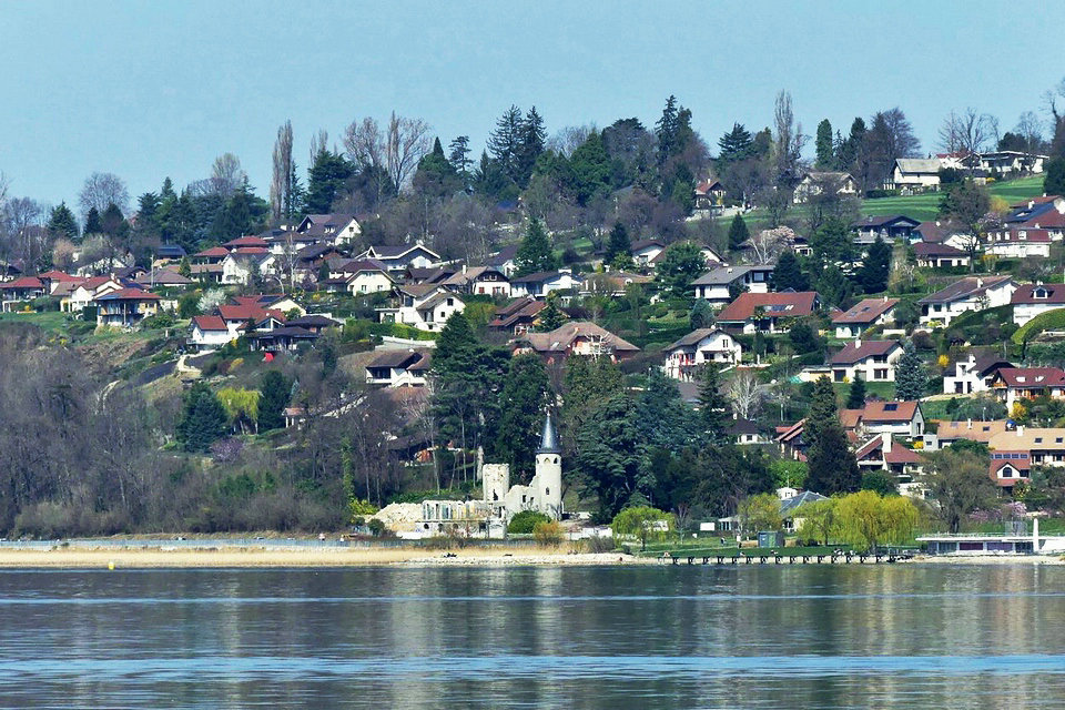
The castle Bonport is a castle from the end of xvi th century, the seat of the lordship Bonport or Great Vine, located in France in the municipality of Tresserve in the department of Savoie in the region Auvergne-Rhône-Alpes.
The castle is located in Savoie at the foot of the hill of Tresserve, near the current national road 201 which took the place of the old avenue des Peupliers and which was a land road link between the municipalities of Tresserve and Aix -les-Bains.
It consisted of a building of 400 m 2 of floor space and included four levels. Its general architecture was of a cross-shaped building. On each side were contiguous two turrets on the west face in the two interior angles that constituted the crossed shape of the building. Originally, it also had a private port on the east shore of Lac du Bourget, consisting of a dike. This port disappeared, around 1885, due to the construction of the railway line between Aix (Choudy) and Saint-Jean-de-Maurienne as well as the road, around 1860. On this site is now the current Lido beach.
History of the Castle
Castle Bonport was built at the end of the xvi th century, shortly after 1584. The land area of Bonport changed owners several times. We find traces of this area, since 1344, as the property of Humbert de Seyssel. The November 16, 1575, the land of the Grande Vigne, thanks to rights ceded by Emmanuel-Philibert of Savoy to Renée de Savoie, his cousin, wife of Jacques Paillard d’Urfé, Marquise de Bagé, is dependent on that of Bourget. In 1584, Charles Emmanuel I exchange against the County of Rivole, yields to Renee Savoie jurisdiction over the Great Vine and student at County rank.
In 1588, the children of Renée de Savoie sold the Grande Vigne to Charles Veillet, first president of the Senate of Savoy, who sold it in 1590 to Jean-François Berliet, archbishop of Tarentaise, who sold it in 1603 to Louis Bonnier, patrimonial lawyer. On this date, the Duke of Savoy erected the lands of the Grande Vigne in the seigneury of Bonport. In 1674, it was in the hands of François Capré, Lord of Megève, president of the Chamber of Accounts of Savoy; he passes recognition to Duke Victor-Amédée II of Savoy, theFebruary 19, 1686. The Capré family from Megève will keep it until 1734. The motto of this family was “Non indigna coelo” and it was affixed to the front door of the castle. A chapel, cited in 1729, dedicated to the Virgin, completed the estate. In 1760, Les Capré sold the estate to Louis-François Berthier de Crempigny de Saint-Vincent.
In 1806, it was acquired by Mr. Mayen, from Chambéry. Pauline Borghèse, with Talma, is received there inAugust 1812. In 1872, it was owned by Baron Chollet du Bourget. The Countess Hélène de Tollu followed one another, then, in 1901, the British Lord Joseph Charlton-Parr, before being the property of the Gauthier family. The property will then be divided up. The castle, alone, was sold in 1968 to a hotelier in Courchevel, Joseph Alexandre Claret-Tournier. The Tournier family will then leave the operation of the site to private investors who will transform the site into a dance hall called “Le Bassamba” which will be succeeded by the discotheque “Le 502” then finally the two night establishments “L’Étoile”, at basement, with a capacity of 400 people, and on the ground floor the “Château”, with a capacity of 200 people. The other parts of the estate were transformed into a subdivision called “The hill of the poet” and on the side bordering the shore of Lac du Bourget, the “Lido beach”.
The July 19, 2008, at 2 h 50, the castle is devastated by a terrible fire causing the collapse of the roof as well as the floor of the last floor and that of the left tower of the castle. The December 20, 2012, the castle is auctioned for € 275,000 to three hoteliers-restaurateurs in Viviers-du-Lac.
Natural heritage
The area of the municipality is 7.8 km². The altitude varies from 228 meters, at the bottom of the hill, on the shores of the lake, to 331 meters, at the highest point of Tresserve.
The center of Tresserve, as well as most of the accommodation, is at the top of the hill. Subdivisions nevertheless skim the bottom of the town, whether near the Lepic district of Aix-les-Bains or on the other side, facing Lake.
Different molasse slopes are present on Tresserve. More precisely, it is Miocene molasse of the marine type, composed of abundant conglomerates or even sands. The potential instability of this slurry has already caused landslides.
No watercourse crosses the town, which has a relief not conducive to their passage. However, the municipality is subject to the risk of flooding near Lake Bourget and on the banks of Tillet, stream on the border is the town with that of Aix-les-Bains. A flood risk prevention plan was nevertheless created to highlight these areas.