The Route des Grandes Alpes is a 720-kilometer tourist route that crosses the French Alps from north to south, passing through 17 mountain passes, 6 of which are over 2,000 meters above sea level. It starts from Thonon-les-Bains (on Lake Geneva) to join – since 2012 – Nice (on the Mediterranean) with a total of 17,000 meters of vertical drop. The course of the route is signposted (sometimes a bit sparse) and shown on many road maps. The Route des Grandes Alpes is open from June to October 15th.
The Route des Grandes Alpes is one of the famous French routes through the Alps to the Mediterranean. It leads from Thonon-les-Bains on Lake Geneva to Menton on the Côte d’Azur and crosses 16 Alpine passes (6 of which are over 2000 m), including the Col de l’Iseran, the highest road pass in the Alps at 2764 m. The route overcomes a total height difference of 15,700 m over a length of approx. 700 km. The route, opened in 1913 for the first five stages, today consists of 600 km of departmental roads and 68 km of national roads. Several sections form stages of the Tour de France.
Within sight of the route are a number of former military installations that were built between the 17th (Vauban) and 20th (Maginot Line) centuries. A selection: Ouvrage de la Platte (Fort 2000), Barrière de l’Esseillon, Briançon, Redoute de Berwick, Fort de Tournoux, Petit ouvrage de Fressinea and Ouvrage du Castillon.
At the instigation in 1909 the Touring Club of France, the planned tourist route allows you to borrow the alpine passes to interconnect existing valley roads through strategic sections built at the end of the 19th century and sections of acceptable constructed them, in the first half of the 20th century.
The road starts at Thonon-les-Bains and climbs via Les Gets and Cluses. It then heads to Saint-Gervais and Megève, over the Col des Saisies (1,633 m (5,358 ft)). It then passes through Beaufort, Bourg-Saint-Maurice and onto Val-d’Isère. The road then crosses the Col de l’Iseran (2,770 m (9,090 ft)). The road then passes through Modane and over the Col du Galibier (2,642 m (8,668 ft)) and then the Col du Lautaret to La Grave. The road heads to Briançon and then over the Col d’Izoard (2,361 m (7,746 ft)). The road then heads through Embrun and over the Col de Vars (2,111 m (6,926 ft)) and onto Barcelonnette via Jausiers, where the choice can be made to turn south over the Col de la Bonette (2,802 m (9,193 ft))—with access to the highest paved through road in Europe, the Cime de la Bonette—or continue via the Col de la Cayolle (2,327 m (7,635 ft)).
Plot
The road crosses the national parks of Vanoise, Ecrins and Mercantour as well as the regional natural parks of Bauges and Queyras. The towns, villages and passes encountered during the trip from Thonon-les-Bains to Nice are as follows:
Thonon-les-Bains
Thonon-les-Bains is a French commune located in the department of Haute-Savoie (of which it is a sub-prefecture), in the Auvergne-Rhône-Alpes region. Located in the historic region of Chablais and more precisely of the Savoyard (or French) Chablais, on the shores of Lake Geneva, the town is also part of the urban agglomeration of Greater Geneva. It is the third most populous municipality in the department, after Annecy and Annemasse, according to 2016 legal population figures.
Morzine
Morzine is a commune of the Alpes French, located in the valley Aulps in the department of Haute-Savoie, in region Auvergne-Rhône-Alpes in France.
Taninges
Taninges is a French commune located in the department of Haute-Savoie, in region Auvergne-Rhône-Alpes.Taninges is located in the middle valley of the Giffre, on the RD 907 leading to Samoëns in the East and Mieussy in the West at the crossroads of the RD 902 leading from Cluses to Gets.
Le Grand-Bornand
Le Grand-Bornand is a French commune located in the department of Haute-Savoie, in region Auvergne-Rhône-Alpes. Mountain municipality belonging to the community of municipalities of the Valleys of Thones, it had 2,118 inhabitants in 2017. The town is located between the Bornes massif and the Aravis chain. It has obtained the “ tourist town ” label due in particular to the presence of a winter sports resort.
Saint-Jean-de-Sixt
Saint-Jean-de-Sixt (pronounced sɛ ʒɑ dsi) is a French commune located in the department of Haute-Savoie, in region Auvergne-Rhône-Alpes. The town is located in the heart of the Aravis alpine massif, 25 km east of Annecy. It enjoys a mountain type climate. Saint-Jean-de-Sixt is made up of many hamlets which are, among others, Villaret, Forgeassoud, Lombardes, Mont Durand, Mouille and Corengy.
La Clusaz
La Clusaz is a French commune located in the department of Haute-Savoie, in the Auvergne-Rhône-Alpes region. Its inhabitants are called the Cluses or the Chaves in Arpitan. The town’s ski resort was founded with the pioneers in 1907, but its development was confirmed from 1955 with the construction of a cable car. Hence the emergence of sports tourism (skiing, hiking, freeride, freestyle, etc.), which has enabled the development of hotels, restaurants and shops. The town of La Clusaz was classified as a tourist resort by decree of May 25, 1956. Then, by decree of June 18, 1969, Winter sports and mountaineering resort. TheSeptember 17, 2015, La Clusaz has obtained the superior classification ” Station Classée de Tourisme “, awarded for 12 years.
La Giettaz
Giettaz in Savoyard dialect Francoprovenal) is a French commune located in the department of the Savoie, in region Auvergne-Rhône-Alpes. Municipality of the Aravis massif which sometimes earned it the nickname of ” La Giettaz-en-Aravis “, name given to its winter sports resort, located in the hamlet of Plan, its capital is located at the foot of the Aravis pass, on the heights of the Val d’Arly. The village is located at an altitude of 1150 m at the foot of the pass and the Aravis range, the border between Savoie and Haute-Savoie.
Flumet
Flumet is a French commune located in the Savoie department, in the Auvergne-Rhône-Alpes region. The municipal territory hosts a winter sports resort, Flumet – Saint-Nicolas-la-Chapelle. Flumet is a village resort of around 900 inhabitants located at an altitude of 900 meters on a rocky outcrop overlooking the confluence of two mountain streams: the Arly (which has its source in the valley of Megève and flows into the Isère in Albertville) and its main tributary L’Arrondine (which comes from the Aravis massif). Flumet is thus at the center of the Haut Val d’Arly territory, around which five other villages are arranged in a star: Saint-Nicolas-la-Chapelle, La Giettaz, Notre-Dame-de-Bellecombe, Crest-Voland and Cohennoz. All are ski resort villages. These six villages have around 2,800 inhabitants.
Notre-Dame-de-Bellecombe
Notre-Dame-de-Bellecombe is a French commune located in the Savoie department, in the Auvergne-Rhône-Alpes region. Notre-Dame-de-Bellecombe is a small mountain village located between 1,100 and 2,070 m above sea level in the Northern Alps, and more precisely in the Val d’Arly. 25 km from Albertville and 10 km from Megève, the population of this family winter sports resort increases tenfold during the February holidays. The summer also sees its processions of tourists, mainly hikers who like to walk in the mountain pastures. Unlike many larger resorts, the architecture of this small village is still preserved; there are traditional farms and wooded chalets. Since the month of december 2005, the Notre-Dame-de-Bellecombe station is a member of the Espace Diamant, a group of 5 stations with 84 ski lifts.
Arêches-Beaufort
Arêches-Beaufort is a summer tourist and winter sports resort in the Beaufortain region, located in the municipal territory of Beaufort-sur-Doron, in the Savoie department in the Auvergne-Rhône-Alpes region. The station is located in the village of Arêches, dependent on the municipality of Beaufort-sur-Doron, located in the Beaufortain massif. It is located 25 km from Albertville. The slopes are punctuated by a large number of wooden alpine chalets, and numerous herds of cows of tarine breeds and abundance that one meets there.
Cormet de Roselend
The Cormet de Roselend is a pass located in France at an altitude of 1,968 meters between the Beaufortain massif and the Mont-Blanc massif, near Italy. It links the towns of Beaufort-sur-Doron to the west and Bourg-Saint-Maurice to the south-east, towns located in the Savoie department in the Auvergne-Rhône-Alpes region.
Bourg-Saint-Maurice
Bourg-Saint-Maurice is a French commune located in the Tarentaise valley, in the Savoie department in the Auvergne-Rhône-Alpes region. The town is located at an altitude of 840 m, on the banks of the Isère. The highest point of the town is at the Aiguille des Glaciers at 3,816 m. Its winter sports resort, Les Arcs, offers a ski area culminating at 3,226 meters (Aiguille Rouge). The resort and the many peaks accessible by ski offer panoramas over the Tarentaise valley and Mont Blanc.
Valley of Isere
Valley of Isere is a French commune of the department of Savoie and the region Auvergne-Rhône-Alpes. Small high mountain village in the Vanoise massif in Haute-Tarentaise, isolated especially during periods of snow during its past, Val d’Isère becomes, thanks to the development of skiing from the 1930s, a winter sports resort whose fame makes it one of the world’s ski capitals. On the sites of La Daille (Oreiller-Killy piste, known as “O.-K.”) and of the Face de Bellevarde, it hosts each year events of the Alpine Skiing World Cup (the criterion of the first snow since 1955). The resort was the scene of men’s alpine skiing competitions at the 1992 Albertville Olympics, and hosted the 2009 Alpine Skiing World Championships. Its ski area is coupled with that of Tignes under the Espace Killy name. This appellation is now known under the domain name “Val d’Isère Tignes”.
Val Cenis
Val Cenis is a winter sports resort made up of three ski areas (Alpine area of Val Cenis, Nordic area of Val Cenis Bramans and Nordic area of Val Cenis Sardières) spread over the villages of the new municipality of Val-Cenis (Bramans, Lanslebourg-Mont-Cenis, Lanslevillard, Sollières-Sardières and Termignon-la-Vanoise), in the valley of Haute-Maurienne-Vanoise, in Savoie. The alpine domain extends around the Col du Mont-Cenis, on the Italian border. Since 2014, it has been managed by the former European champion of alpine skiing in 1995, Yves Dimier, the former mayor of Lanslevillard Paul Chevallier, being director of the SEM of Mont-Cenis, which manages the network of ski lifts.
Modane
Modane is a French commune located in the Savoie department, in the Auvergne-Rhône-Alpes region. Common in the Maurienne valley, it also belongs to the Vanoise national park. The town of Modane is located in the Alps in the Savoie department between the Vanoise massif to the north and the Mont-Cenis massif and that of Cerces to the south. Crossed by the Arc it extends to the gates of the Haute-Maurienne (the question of whether or not Modane is attached to the Maurienne or the Haute-Mauriennediffers according to the disciplines of economics, geography or geology. For economists, Modane is attached to Haute Maurienne arguing that the city has a very strong influence on the villages of Haute Maurienne, through economic and administrative infrastructure (shopping centers, schools or SNCF train station for example). However, for the vast majority of analysts, Modane is a town attached to the middle part of this valley, as well by the relief (all the downstream part of the canton is hollowed out in the coal furrow which extends to Saint-Michel- de-Maurienne), than by the industrial history of this sector.
Saint-Michel-de-Maurienne
Saint-Michel-de-Maurienne is a French commune located in the Savoie department, in the Auvergne-Rhône-Alpes region. In 1972, the town merged with the towns of Beaune and Thyl. Covering an area of 3,631 hectares, Saint-Michel-de-Maurienne extends along a north-south axis and is crossed by the Arc from east to west. It is bounded on the northern slope of the valley by Pointe de la Masse to the north-west and Mont Bréquin to the north-east, which also marks the maximum altitude of the town (3,130 meters). On the southern slope, the town marks the start of the Col du Galibier road leading to the Dauphiné and the Hautes-Alpes. However, it does not extend as much as on the northern slope, limited by Saint-Martin-d’Arc from the south bank of the Arc on its western part, and Valmeiniera few hundred meters higher in the east. The east-west axis of Saint-Michel-de-Maurienne extends over less than 5 kilometers.
Valloire
Valloire is a French commune located in the Savoie department, in the Auvergne-Rhône-Alpes region. It is the southernmost of the towns in Savoy. This village above sea level, consists of 17 hamlets, is a tourist resort Alpine for winter sports and summer. Valloire is located in the center and south of the Maurienne valley, not far from the Franco-Italian border and bordering the Hautes-Alpes department, on the route des Grandes Alpes which connects Lake Geneva to the Mediterranean, between the Col du Télégraphe and the legendary Col du Galibier. Valloire (to 1405 of altitude at the foot of the church) is located on the entire watershed of a stream descending from south to north until around Saint-Michel-de-Maurienne: the Valloirette.
Serre Chevalier
Serre Chevalier is a winter sports resort located in the Guisane valley in the Hautes-Alpes department, Southern Alps, near the Ecrins national park. It was created in 1941 with the construction of the cable car from Chantemerle to the top of Serre-Chevalier (2,483 m). The historic emblem of the resort is an eagle, with reference to the coat of arms of Baron Borel du Bez. It is the largest winter sports resort in the Southern Alps both in terms of the length of the track and the number of visitors. It occupies the valley of the Guisane from Briançon to Monêtier-les-Bains. Located on the edge of the Ecrins National Park, close to the Franco-Italian border, it offers access to many winter and summer activities.
Briancon
Briancon s a French commune located in the department of Hautes-Alpes (of which it is the sub-prefecture) in the Provence-Alpes-Côte d’Azur region, and historically attached to the Dauphiné. It is the city-center of a small agglomeration of six municipalities, the urban unit of Briançon. The territory of which Briançon is the main town is called Briançonnais; it covers the north of the Hautes-Alpes department. Briançon is considered the highest town in France (1,326 m). Its inhabitants, numbering 12,370 in 2015, are called the “Briançonnais”. Its Vauban fortifications (the city wall, the forts of Salettes, des Têtes, Randouillet, the Y communication structure and the Asfeld bridge) have been on the UNESCO World Heritage list since July 7, 2008 alongside the eleven other sites of the Network of major sites of Vauban.
Guillestre
Guillestre is a French commune located in the department of Hautes-Alpes in area Provence-Alpes-Côte d’Azur and central office of the canton of the same name. The commune of Guillestre is located at an average altitude of 1000 m, dominating the left bank of the Guil gorges, shortly before its confluence with the Durance. Located at the Porte du Queyras, it is the unique access point to this valley, especially during the winter months (Col Agnel and Col Izoard being closed part of the year). Guillestre is a crossroads and a starting point for the Col d’Izoard, the Col de Vars and the Col Agnel. It is also a crossing point between Embrun and Briançon.
Vars
Vars is a French commune located in the department of Hautes-Alpes in area Provence-Alpes-Côte d’Azur. It is known as a winter sports resort. Vars is an alpine town located on the axis that connects the towns of Guillestre and Barcelonnette, via the Col de Vars at 2,108 m. From the top of the pass, looking south, it is possible to make out the gorges of Ubaye. Vars is located at the gates of the regional natural park of Queyras. Part of the municipality, the Val d’Escreins reserve, one of the first municipal reserves in France created in 1964, was integrated into the park from its creation in 1977 until 2010. At the end of 2017, the municipality decided to reintegrate the reserve. from the Val d’Escreins to the regional natural park of Queyras, a decision validated by decree on May 14, 2019, until the charter expires in April 2021 1, 2. At an altitude of 3,385 m, the Font Sancte is the highest point in the town.
Barcelonnette
Barcelonnette is a French commune, sub-prefecture of the department of Alpes-de-Haute-Provence in the region Provence-Alpes-Côte d’Azur. The name of its inhabitants is Barcelonnettes. Barcelonnette is a mountain town, entirely located at an altitude of more than 1,100 meters. It is the largest municipality in the Ubaye valley, of which it forms the administrative, commercial and urban center. Barcelonette is located in the Alps of southern France, in the northeast of the Alpes-de-Haute-Provence department, in the Provence-Alpes-Côte d’Azur region. Located in the widest area of the Ubaye valley, it is linked by it to the region of Gap and the Durance valley, and by passes to neighboring Italy and the department of Alpes- Maritimes. Barcelonnette is located at an altitude of 1,135 meters, near the confluence of the Ubaye and Bachelard rivers.
Valberg
Valberg is a winter sports resort located in the towns of Guillaumes, Péone and Beuil in the Alpes-Maritimes department (Provence-Alpes-Côte d’Azur region), in the upper Niçois region. The station is located in the geographical area of the Southern Alps, and extends from the Mont Mounier massif (2,817 m) in the north to that of the Dôme de Barrot (2,136 m) in the south. It stretches over two kilometers in adret, at an altitude of 1,700 m, between the Haut-Var valley to the west and the Haut-Cians valley to the east. Its urbanized part is located mainly in the municipality of Péone. Opened in 1936, the station celebrated its 80th anniversary in 2016.
Saint-Martin-Vésubie
Saint-Martin-Vésubie (Sant Martin of Lantosca / San Martin de Lantousca in Nice) is a French commune located in the department of Alpes-Maritimes in the region Provence-Alpes-Côte d’Azur. Its inhabitants are Saint-Martinois . Until 1860, the official name was in Italian: San Martino Lantosca. Chief town of the Alpes-Maritimes canton and last village north of the Vésubie valley, Saint-Martin-Vésubie is the main gateway to the Mercantour national park. In 1987, Escapade, the office of the Guides of Mercantour was founded in the village by the high mountain guide Hervé Gourdel. Called until 1889 Saint-Martin- Lantosque because belonging to the old Val de Lantosque (former name of Vésubie), Saint-Martin-Vésubie, was, from 1864, renowned for the quality of its environment, its waters and of its summer climate, far from the stifling heat of the coast.
Sospel
Sospel is a French commune located in the department of Alpes-Maritimes, in region Provence-Alpes-Côte d’Azur. Its inhabitants are called the Sospellois. In Alpine sospellois is said Sospèr (pronounced Souspèr) and E Sospelencs for its inhabitants. Sospel is located 20 km from Menton, at an altitude of approximately 350 m, at the gates of the Mercantour National Park. The village occupies the central basin formed by three valleys: the Bévéra, to the north-west and to the south; le Merlançon, to the east.
Menton
Menton is a French commune in the Alpes-Maritimes department located on the Franco-Italian border, near the principality of Monaco (7 km), and a famous seaside tourist resort on the Côte d’Azur. Menton is located on the Franco- Italian border (the border town on the Italian side is Ventimiglia) and it is nicknamed “Pearl of France” (this name is due to the geographer Élisée Reclus in his Universal Geography). The city is open to the Mediterranean Sea and has a campanile.
Nice
Nice is a common South East of France, prefecture of the department of Alpes-Maritimes and the second city in the region Provence-Alpes-Côte d’Azur behind Marseille. Located at the south-eastern end of France, about thirty kilometers from the Franco-Italian border, it is established on the shores of the Mediterranean Sea, along the Baie des Anges and at the mouth of the Paillon. Nice is located in the extreme south-east of mainland France, not far from the Italian border (thirty kilometers), on the shores of the Mediterranean. It is part of the Riviera of which it is the western end. It is bordered by the Bay of Angels and is surrounded by several hills. Although the boundary of the Côte d’Azur is poorly defined, it is its largest city. The city is located in an eccentric position in relation to the national territory, as within the Provence-Alpes-Côte d’Azur region.
Mountain passes
The following pass heights are reached on the Route des Grandes Alpes:
Col des Gets (1163 m)
Col de la Colombière (1613 m)
Col des Aravis (1487 m)
Col des Saisies (1650 m)
Cormet de Roselend (1967 m)
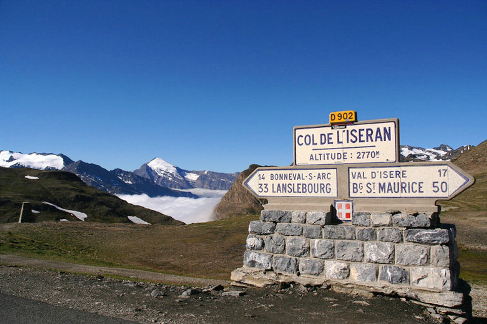
Col de l’Iseran (2764 m)
Col du Télégraphe (1566 m)
Col du Galibier (2645 m)
Col du Lautaret (2058 m)
Col d’Izoard (2360 m)
Col de Vars (2109 m)
Col de la Cayolle (2326 m)
Col de Valberg (1673 m)
Col de la Couillole (1678 m)
Col Saint-Martin (1500 m)
Col de Turini (1607 m)
Col de Castillon (706 m)
The information about the number of passes on the Route des Grandes Alpes varies depending on the counting method. For example, the south ramp of the Col du Galibier ends at the top of the Col du Lautaret, but from the Col du Lautaret only one of the two ramps on the east ramp is used. Also, in route descriptions, only a selection of the passes is often given. B. not even mentioned on the official homepage.
History
Although initially taking sections of strategic roads, the route des Grandes Alpes is essentially a tourist route originally promoted by the Touring-Club de France and the PLM railway company under the name “route des Alpes”.
Already in 1900, François Arnaud declared about him: “The next day when the national road linking Ubaye to Var, via the Cayolle pass, will be completed, we will have from Nice to Savoy via the Cayolle passes, de Vars and du Galibier, 20 km behind the border, a motorable road which will be the favorite passage, almost obligatory, of large tourism and foreign colonies who share their stay in France between the Mediterranean coast and Savoy. ”
It’s the April 26, 1909that Léon Auscher – vice-president of the Touring club of France – read his report devoted to the project of the Route des Alpes which is to link Evian to Nice by taking the most picturesque passes and passing through the most interesting valleys. It will be, he concludes, a unique route in Europe and, we can say without fear of being accused of exaggeration, the most beautiful mountain road in the world. This is, in 1909, the birth certificate of the “Route des Alpes” which will be renamed “Route des Grandes Alpes” in 1950.
La Route des Grandes Alpes has been projected at the beginning of the XX century for two reasons. The first was to connect the different alpine valleys from north to south because several links were still missing. As the road was of strategic interest (proximity to Italy, link between Alpine forts, etc.), the State therefore financed the construction of most of the missing sections, the military engineering by carrying out part and the Touring Club of France participating in the realization of some of them including that of the impressive section of the Bachelard gorges between Barcelonnette and the Col de la Cayolle. The PLM company was also interested in this: a north-south rail link between all these valleys would have required the construction of long and many very expensive tunnels for too low income. The summer operation of a coach line was therefore much more suitable and profitable.
The second reason, which is the most important, is tourism: the Touring-Club de France, which sought to develop cycling and then automobile tourism, prompted the construction of several tourist routes, including the Route des Alpes, which became Route des Grandes Alpes in 1950. It In particular, built numerous orientation tables and signboards throughout its initial 615 kilometers. Because it was not until 1995 that its initial route from Thonon-les-Bains to Nice via the Var valley was changed to replace it with that from Thonon-les-Bains to Menton by a more “alpine” route in the Alpes-Maritimes departmentand passing – from Guillaumes – through Valberg, Saint-Martin-Vésubie and Sospel but then avoiding the section of the Daluis gorges cut into the red rocks of the Dôme de Barrot.
First works and inauguration
Under the responsibility of the State, the liaison work of existing road sections had begun at the end of the XIX century and the lawDecember 28, 1896had even declared their classification in the national road system. The first trips were organized in 1911 by the PLM company even though the said road project was not yet completed. In the Alpes-Maritimes, a section of the said road was even to be inaugurated, theAugust 10, 1914, by the President of the Republic Raymond Poincaré, from Nice to the Col de la Cayolle via the commune of Entraunes, if there had not been the entry into the war of France following the assassination of Archduke Franz Ferdinand of Austria in Sarajevo. National pride will be expressed in this way: the French road to the Alps is higher than the road to the Stelvio pass, whose northern slope is then in Austria, it is considered more beautiful than the roads of Switzerland and it originally crosses a total vertical drop of 10,675 meters.
This future “Route des Grandes Alpes” from Évian – Thonon to Nice – first declared of public utility by the law ofApril 5, 1912 – will therefore use several sections of national roads which will only be affected by number 202 by the ministerial decision of the December 16, 1920. The future “Route des Grandes Alpes” will therefore not become the RN 202 until 1920.
In 1911, the Touring Club de France “organized a major promotional campaign to which the press and personalities were invited. The PLM company is setting up a whole network of tourism by motor coaches from its stations. »And fromJuly 1911, the first tourists took part of this planned route, in particular from Nice via the Colle-Saint-Michel and the Col d’Allos, the road to the Col de la Cayolle not yet open. Moreover, the projected route of the road is not yet completed since, besides the neck of the Cayolle passes of the Iseran and the Croix-de-Fer are still accessible only by mule tracks. From the first year, more than 15,000 passengers will be transported in this way – in particular by Berliet 1 CB coaches – during the two and a half months of operation. The route des Alpes from Évian-Thonon to Nice – renamed “Route des grandes Alpes” in 1950 – will not be completed untilJuly 1937with the inauguration of the Col de l’Iseran (2,770 m) by the President of the Republic Albert Lebrun.
World War I
From 1914, the road to Cayolle was damaged and the road to the Alps again passed through the Col d ‘ Allos, while requisitions due to the war interrupted the tourist coach service untilJuly 1919. On the other hand, several route adjustments were made later: the road to the Col de l’Iseran, the highest point of the route at 2,770 meters, was not inaugurated until 1937. And the last development that gave the road its current appearance was the construction of Cormet de Roselend in 1970. However, the route initially planned was not entirely completed: the road joining the Beaufortain valleyto Contamines-Montjoie via the Col du Bonhomme (2329 m) was never built.
It was also during the war, in 1917, that the project for a Franco-Italian route in the Alps was decided. Project which consists of:
on the one hand the French Alpine road connecting Thonon-les-Bains to Nice via the Col des Gets, Le Fayet, the Col du Bonhomme, Bourg-Saint-Maurice, the Col de l’Iseran, Lans-le-Bourg, the Col du Galibier, Briançon, the Col de l’Izoard, Guillestre, the Col de Vars, Barcelonnette and the Col de la Cayolle;
on the other hand, an Italian Alpine road linking Le Bouveret (in Switzerland) to Genoa via Martigny, the Grand-Saint-Bernard pass, Aosta, Turin, Susa, Césane, Pignerol and Coni;
and finally links between the two roads, by the passes of Montets, Petit-Saint-Bernard, Mont-Cenis, Mont-Genèvre, the Lacroix pass, the Larche pass and the Tende pass, the pass road Lacroix still to be built.
Between the wars
The PLM service resumed in 1919 and transported around 25,000 tourists by Rochet-Schneider 216 coach each summer from Nice to Thonon, in six stages (stops at Barcelonnette, Briançon, Grenoble and Annecy). In 1920, the State decided to classify as national road number 202 (RN 202), from Nice to Thonon-les-Bains, all the road sections then forming the route des Grandes Alpes. The construction project – voted in 1930 – of the section of road passing through the Col du Bonhomme (2370 m) was definitively abandoned in 1934. After a first car crossing inSeptember 1934, the road to the Iseran pass (2,770 m) was inaugurated onJuly 10, 1937; the depth of snow in some snow drifts was still so great that the Ponts et Chaussées decided it would be better to dig a tunnel rather than clear it.
With the crisis of the 1930s and the reorganization of the railway in France (creation of the SNCF in 1938), the route des Alpes is no longer promoted as such. Coach connections are maintained, but with the aim of providing local service only.
Thirty Glorious
After the downturn due to World War II, the Nice-Thonon coach service struggled to attract customers. All the more so as a new Route des Alpes – located further west, open all year round and extending to the south by the Route Napoléon opened in 1932 – competes with it. The primitive Alpine route was renamed “Route des Grandes Alpes” in 1950. The opening of the Cormet de Roselend section in 1970, however, completed its course but it has relatively gone out of fashion.
Revival at the end of XX century
The route des Grandes Alpes – during its opening period, especially in summer – is increasingly frequented daily, whether on all or part of the route, by hundreds or even thousands of motorists, motorcyclists and cyclists. From a simple service by coaches or by a very limited number of passenger cars, we will move to a mass attendance especially in summer but also, more and more, in spring and autumn. In 1992, the Commission for Planning and Economic Development of the Alps relaunched the concept of the Grandes Alpes route and its advertising as a tourist and decompartmentalization route. Its strategic function has been almost nil since World War IIand it is therefore its tourist role that is highlighted. The route des Grandes Alpes is now open in its entirety from June to September depending on the snow cover of the highest passes and in particular the Cayolle pass, the Galibier pass and the Iseran pass. The Tour de France cyclist takes part of its passes almost every year.
Numbering
This route des Grandes Alpes corresponds for the most part to the old national road 202 often downgraded to RD 902.
D 902 from Thonon-les-Bains to Cluses [= 59 km ]
D 4 from Cluses to Saint-Jean-de-Sixt [= 34 km ]
D 909 from Saint-Jean-de-Sixt to Flumet [= 22 km ]
D 218 b from Flumet to Beaufort-sur-Doron (place called Manant) [= 29 km ]
D 925 / D 217 from Beaufort to Cormet de Roselend [= 23 km ]
D 902 from Cormet de Roselend to Bourg-Saint-Maurice [= 20 km ]
N 90 / D 1090 from Bourg-Saint-Maurice to Séez [= 3 km ]
D 902 from Séez to Lanslebourg-Mont-Cenis via the Col de l’Iseran [= 77 km ]
N 6 from Lanslebourg to Saint-Michel-de-Maurienne [= 41 km ]
D 902 from Saint-Michel-de Maurienne to the Col du Lautaret via the Col du Galibier [= 42 km ]
D 1091 from Col du Lautaret to Briançon [= 28 km ]
D 902 from Briançon to Saint-Paul-sur-Ubaye (place called Les Gleizolles) via the Col de Vars [= 90 km ]
D 900 from Gleizolles to Barcelonnette [= 16 km ]
D 902 from Barcelonnette to the Col de la Cayolle [= 30 km ]
D 2202 from the Col de la Cayolle to Guillaumes [= 33 km ]
D 28 from Guillaumes to Beuil [= 19 km ]
D 30 from Beuil to Saint-Sauveur-sur-Tinée [= 23 km ]
D 2205 / then D 2565 from Saint-Sauveur to La Bollène-Vésubie (place called Boutas) [= 39 km ]
D 2566 from La Bollène-Vésubie to Menton via the Col de Castillon [= 50 km ]
D 6007 from Menton to Roquebrune-Cap-Martin [= 3 km ]
D 2564 from Roquebrune-Cap-Martin to Villefranche-sur-Mer [= 19 km ]
M 33 to Villefranche-sur-Mer [= 2 km ]
D 6007 from Villefranche-sur-Mer to Nice [= 5 km ]