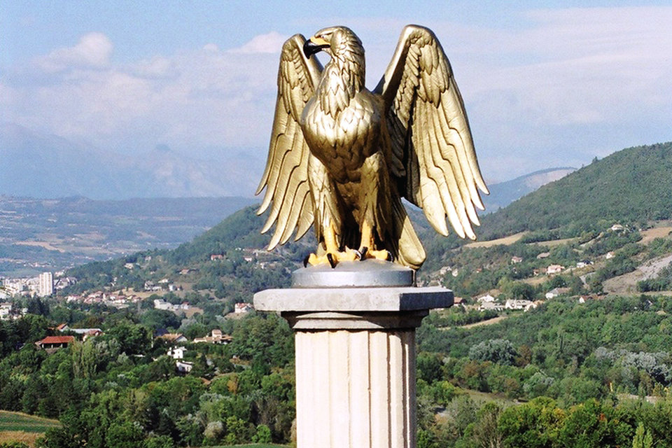
The Route Napoléon is the route taken by Napoléon in 1815 on his return from Elba. It is now concurrent with sections of routes N85, D1085, D4085, and D6085. The route begins at Golfe-Juan, where Napoleon disembarked 1 March 1815, beginning the Hundred Days that ended at Waterloo. The road was inaugurated in 1932 and meanders from the French Riviera north-northwest along the foothills of the Alps. It is marked along the way by statues of the French Imperial Eagle.
The Hundred Days is the period of the history of France between the return to France of the Emperor Napoleon I, on 1 March 1815 and the dissolution of the Commission Napoleon II, in charge of the executive branch after the second abdication of Napoleon I on July 7, 1815. From 1 st to March 20, 1815, Napoleon’s reconquest of power was punctuated by his landing in Golfe Juan and his increasingly triumphant march towards Paris. This period is nicknamed the “flight of the Eagle ” by historiography favorable to the emperor. From March 20 to June 22, 1815This is the second imperial reign of Napoleon I er. This period saw the reestablishment of control of the administration and the army by Napoleon, the amendment of the Constitution with the Additional Act, and the resumption of war against the Allies which ended with the French defeat at Waterloo, and the abdication of the emperor.
The Napoleon Route, or national road 85, is a French national road connecting in 2015 Le Pont-de-Claix on the A480 motorway to La Saulce via Gap and Aubignosc to Barrême via Digne-les-Bains. In the past, it started in Bourgoin-Jallieu, breaking away from the RN 6, to end on the Côte d’Azur, first in Cagnes-sur-Mer, then in Golfe-Juan. Between Grenoble and Vallauris (near Cannes), it follows part of the route qu’emprunta Napoleon I his return from the island of Elba, in the early Hundred Days. The RN 85 forms part of the Route Napoléon.
History
Construction of the section crossing the Digne and Castellane pre-Alps began at the end of the Ancien Régime. The clue of Chabrières was reached in 1778.
Under Napoleon I
After disembarking the 1 March 1815 in Vallauris in the Gulf of Juan, with a small army of 1,200 men, Napoleon heads for Grasse to reach the Alps via the Durance valley. When he takes this road, it is in a very uneven state depending on the sector of terrain. Between Grasse and Digne, it has not yet been built, and the emperor has to go through mule tracks.
The Napoleon route and the “Flight of the Eagle”
March 1 1815: disembarking in Golfe-Juan, Napoleon and his small troop reach Cannes where they arrive late and from where they leave early.
March 2: wanting to avoid the route of the Rhone which he knows hostile, Napoleon then takes the road to Grasse to gain, by the Alps, the valley of the Durance. Beyond Grasse, the column engages in bad mule tracks and stops at Saint-Vallier, Escragnolles, and Séranon.
March 3: after a night’s rest, the troop reaches Castellane; in the afternoon, it reaches Barrême.
March 4: Napoleon finds the road suitable for motor vehicles in Digne and stops in the evening at the castle of Malijai, impatiently awaiting news from Sisteron whose citadel, commanding the narrow passage of the Durance, may block his route.
March 5: Sisteron is not guarded and Napoleon has lunch there, then leaves the locality in an atmosphere of budding sympathy. In the evening, he arrives in Gap and receives an enthusiastic welcome.
March 6: he sleeps in Corps.
March 7: he reaches La Mure, then finds in front of him, in Laffrey, troops sent from Grenoble. It is here that the famous episode is located which today commemorates a monument in the “prairie de la Rencontre”. That same evening, Napoleon made his entry into Grenoble with cries of “Vive l’Empereur”.
The armies sent to stop him turns out welcome him as heroes everywhere on the road. Napoleon arrives without firing a shot in Paris. This climb in Paris is known as the “Flight of the Eagle”, inspired by Napoleon’s words: “The Eagle will fly from steeple to steeple up to the towers of Notre-Dame”. In 1932, the Napoleon road was inaugurated between Golfe-Juan and Grenoble. Flying eagles dot this course.
20th century
In the XX century, given the success of this historic road, improves its route, sometimes deviating from the original dirt road followed by the emperor. It was paved in 1927 and received the name Route Napoléon in July 1932.
During the campaign in Provence (August 1944), Napoleon road is used as a route into the armored unit Task Force Butler, to encircle the XIX retreating German army.
At the end of the XX century, the connection path between Grasse and Cannes a new route to the motorway template is built, the penetrating Cannes-Grasse (D 6185) who gets an iconography inspired by the Napoleonic symbols including bee declined on several civil engineering works.
Plot
Between Vizille and Laffrey, the road takes the Laffrey ramp which has a very steep gradient (signs indicating 12% in the direction of descent when leaving Laffrey), with a drop of over 650 meters; the speed is limited to 70 km / h (40 km / h for authorized heavy goods vehicles) by prefectural decree of 23 June 2004. Two prefectural decrees of 1975 and 1979 regulate access to the descent, in particular for the local service of the Matheysin plateau or for certain school services.
Itinerary
From Cagnes-sur-Mer to Grasse (D 2085)
Until the 1972 reform, the RN 85 continued towards Cagnes-sur-Mer to join the RN 7, the A8 motorway and Nice. This route is downgraded D 2085. The municipalities crossed were: The national road 85 had a branch: the RN 85, connecting Saint-Firmin to La Chapelle-en-Valgaudémar. It was decommissioned in 1972 R & D 985.
Cagnes sur mer
Cagnes sur mer is a French commune located in the department of Alpes-Maritimes, in region Provence-Alpes-Côte d’Azur. It is part of the Nice Côte d’Azur metropolis. Cagnes-sur-Mer is a town in south-eastern France located on the shores of the Mediterranean Sea, between Saint-Laurent-du-Var and Villeneuve-Loubet. It stretches along a cove offering nearly four kilometers of beach and is surrounded by hills, including that of the castle which rises to 90 meters above sea level.
Villeneuve-Loubet
Villeneuve-Loubet (Vilanòva Lobet in Provencal in the classical standard and Vilonovo-Loubet in the Mistralian standard) is a French commune located in the department of Alpes-Maritimes, in the Provence-Alpes-Côte d’Azur region, on the Côte d ‘ Azure. The city is located between the two largest towns in the Alpes-Maritimes, Cannes (17 km west) and Nice (8 km east). Located between Cagnes-sur-Mer and Antibes, at the mouth of the Loup, this town is made up of two ancient villages: the old village of Villeneuve, inland, and the village of Loubet, on the shores of the Mediterranean. Between Cannes (17 km) and Monaco (35 km) and open to the middle-country of Saint-Paul-de-Vence and Grasse, Villeneuve-Loubet offers its visitors nearly four kilometers of coastline. Seaside resortin its own right, it is a base of choice for staying on the Côte d’Azur and for quickly accessing the various activities and curiosities of the Alpes-Maritimes. The town is part of the CASA (Community of agglomeration Sophia Antipolis).
Roquefort-les-Pins
Roquefort-les-Pins is a French commune located in the department of Alpes-Maritimes in the region Provence-Alpes-Côte d’Azur. Its inhabitants are called the Roquefortois. Roquefort-les-Pins is a town of Alpes-Maritimes standing at 18 km from Cannes, 17 km from the Nice airport and 13 km from Grasse.
Le Rouret
Le Rouret is a French commune located in the department of Alpes-Maritimes in the region Provence-Alpes-Côte d’Azur. Its inhabitants are called the Rouretans. Le Rouret is a village located in the Alpes-Maritimes (06), halfway between the two agglomerations of Cannes (26 km) and Nice (28 km). Grasse is about ten kilometers away.
Chateauneuf-Grasse
Châteauneuf-Grasse (sometimes locally named Châteauneuf not officially) is a French commune located in the department of Alpes-Maritimes, in the Provence-Alpes-Côte d’Azur region. The village itself is located at the top of a hill, but the territory of the commune includes other hills as well as the flatter terrain of Pré-du-Lac, where homes and businesses developed in the 1980s. The sources are numerous on the territory of the town (there are several washhouses), and are easily spotted in the groves of plane trees and fig trees which surround them, as in the place called Fouan-Figuière.
From Golfe-Juan to Barrême
Cannes
Cannes is a French commune in the urban community of Lérins Cannes Country located in the department of Alpes-Maritimes, in region Provence-Alpes-Côte d’Azur on the French Rivieraof which it is a flagship city. Ligurian fishing village during Antiquity, linked to the legends of Saint-Honorat and the man in the iron mask on the Lérins islands off the bay of Cannes, health resort and seaside resort of the Côte d’Azur in the 19th century th century, the city took off with the construction of holiday residences by English and Russian aristocrats, then, from the beginning of the 20 th century, of hotels.of luxury for wealthy tourists, constituting its architectural heritage. With a cutting-edge industry, a small business airport, several ports and a convention center, anchored in the Bay of Cannes, bordered by the Massif de l’Esterel to the west, the Gulf Juan to the east and the Mediterranean Sea, Cannes is today known worldwide for its film and yachting festivals and for its Croisette lined with a few palaces.
Mougins
Mougins is a French commune in the Alpes-Maritimes department, in the Provence-Alpes-Côte d’Azur region. The town, historically peasant specializing in picking jasmine, is today massively urbanized by an abundance of neo-Provencal style villas due to the urban sprawl, which earned it its nickname of garden city. Tourism is mainly developed in art: gastronomy and exhibitions of artists (painters and sculptors). Its strategic location makes Mougins a common “crossroads” between the agglomerations of Cannes and Grasse linked to the Sophia Antipolis technology park, which causes significant traffic jams on a daily basis during rush hour. Mougins is located about six kilometers from the Mediterranean Sea, north of the municipalities of Cannes and Le Cannet and south of Grasse. The town is crossed by the national road 85 which links Cannes and Grasse to Grenoble (also known as the Napoleon road).
Mouans-Sartoux
Mouans-Sartoux (Mouans-Sartous in Provence in standard Mistralian, Moans-Sartós in Provence of classical norm) is a French commune located in the department of Alpes-Maritimes in the region Provence-Alpes-Côte d’Azur. Mouans-Sartoux is located in the Grasse valley between Cannes (12 km) and Grasse (8 km) and in the immediate vicinity of Mougins. The commune of Sartoux was reunited with the commune of Mouans, which took the name of Mouans-Sartoux on this occasion, by imperial decree of March 28, 1858 signed by Napoleon III.
Grasse
Grasse is a French town of Provence, located in the department of Alpes-Maritimes in the region Provence-Alpes-Côte d’Azur. Sub-prefecture of the Alpes-Maritimes, Grasse is the fourth largest city in the department in terms of population. Grasse is a major town in the middle-country of the Côte d’Azur located in the west of the Alpes-Maritimes department 12 km north of Cannes on the Mediterranean coast. It is also in the south-east of France. Its distance as the crow flies with the prefecture, Nice, is 29 km for a heading of 79 °, and with the national capital, Paris, is 677 km for a heading of 330 °. Since the xvii th century, the city is considered the world capital of perfume. She obtained three flowers in the Contest of cities and villages in bloom and was promoted ” City of Art and History”. It is also “Internet City”.
Saint-Vallier-de-Thiey
Saint-Vallier-de-Thiey is a French commune located in the department of Alpes-Maritimes in the region Provence-Alpes-Côte d’Azur. Its inhabitants are called the Vallerois. By decree of May 17, 1957, Official Journal of May 22, 1957 with effect from May 23, 1957, Saint-Vallier becomes Saint-Vallier-de-Thiey. Between the Alps and the sea (altitude 730 m) on the Route Napoléon (RN 85), in the center of a tourist region, 29 km from Cannes, 12 km from Grasse (the city of Perfumes), 50 km from Nice and its airport international.
Escragnolles
Escragnolles is a French commune located in the department of Alpes-Maritimes in the region Provence-Alpes-Côte d’Azur. The Treasury dóu Felibrige of Frédéric Mistral gives forms Escragnolo and Escregnoro as place names.
La Garde
La Garde is a French commune, located in the department of Alpes-de-Haute-Provence in the region Provence-Alpes-Côte d’Azur. The village is located at 927m above sea level. La Garde is one of the 46 member municipalities of the Verdon Regional Natural Park. The neighboring municipalities are Demandolx, Peyroules, Châteauvieux (in the Var) and Castellane.
Castellane
Castellane is a French commune, sub-prefecture of the department of Alpes-de-Haute-Provence in the region Provence-Alpes-Côte d’Azur. With around 1,600 inhabitants, Castellane has the distinction of being the least populated sub-prefecture in France. The town of Castellane is a very old town located upstream from the Gorges du Verdon. The city is located 724 meters above sea level. Castellane is one of the 46 member municipalities of the Verdon Regional Natural Park. The Roc, or Roc Notre-Dame dominates the city from its 184 m high. This is the site it occupied in the High Middle Ages, and a classified site.
Senez
Senez is a French commune, located in the department of Alpes-de-Haute-Provence in the Provence-Alpes-Côte d’Azur region. Senez is an example of these tiny bishoprics of Provence whose church dimensions unrelated to the importance of the village, today recalls the old statute. The village is located at an altitude of 784 m 2, in the Montdenier massif. Small village, located 5 kilometers from Barrême, Senez is a very large commune with very few inhabitants and dwellings. The houses are typical of the Provencal architectural style.
From Barrême to La Saulce (N 85 partially decommissioned)
Barreme
Barrême is a French town located in the department of Alpes-de-Haute-Provence, in the Provence-Alpes-Côte d’Azur region. The village is located at 722m altitude and is 118 km from Nice, 30 km from Digne-les-Bains, 90 km from Grasse and 76 km from Draguignan.
Chaudon-Norante
Chaudon-Norante is a French commune, located in the department of Alpes-de-Haute-Provence in the Provence-Alpes-Côte d’Azur region. The village is located at an altitude of 666m. The municipality has 1,279 ha of woods and forests, or 34% of its area.
Chateauredon
Châteauredon is a French commune, located in the department of Alpes-de-Haute-Provence in the Provence-Alpes-Côte d’Azur region. The village is located at an altitude of 613m.
Digne-les-Bains
Digne-les-Bains is a French city, capital of the department of Alpes de-Haute-Provence, located in the region Provence-Alpes-Côte d’Azur. Located on the edge of the Prealps of Digne, on either side of the Bléone, Digne-les-Bains is the capital of the Alpes de Haute-Provence department. Placed at the geographical center of the department, this town is home to 16,844 inhabitants, making it one of the smallest prefectures in France in terms of its population.
Mallemoisson
Mallemoisson, or Mallemoisson-les-Grillons after the name of the village, chief town, is a French commune, located in the department of Alpes-de-Haute-Provence in the Provence-Alpes-Côte d’Azur region. The old village is located at an altitude of 505m. The capital is located in the village of Les Grillons.
Malijai
Malijai is a French commune, located in the department of Alpes-de-Haute-Provence in the region Provence-Alpes-Côte d’Azur. The town has 728 ha of woods and forests, or 27% of its area.
L’Escale
L’Escale is a French commune, located in the department of Alpes-de-Haute-Provence, in the Provence-Alpes-Côte d’Azur region. Located on the edge of the Digne pre – Alps, on the edge and east of the Durance, this town was once a stopover for navigation. Today, a dam-bridge has been built there, and human occupation has taken place on the shores of the reservoir. Very old occupation, the town was the scene of events during the wars of religion, then during the resistance of this part of Provence to Napoleon III. It experienced a rural exodus, before exceeding 1,000 inhabitants in the 1980s. An agricultural quality (olive oil, lamb AOC) becomes important in this region.
Chateau-Arnoux-Saint-Auban
Château-Arnoux-Saint-Auban is a French commune, located in the department of Alpes-de-Haute-Provence in the Provence-Alpes-Côte d’Azur region. The territory of the municipality is densely occupied in ancient times. Its favorable position on the banks of the Durance and on a busy road motivated the establishment of a castle, named after one of its first lords. Château-Arnoux (Roche-Arnoux during the Revolution) remains a single rural district until the beginning of xx th century. Its location far from the borders, protected from invasions by the Alps, and equipped with a rail link, motivated the installation of a major chemical weapons manufacturing plant in the village of Saint-Auban during the First World War., which changes its face until today, almost a century later. Today, the name of the town takes into account this duality, a medieval village on one side, an industrial town on the other, whose Arkema factory has been running many risks since the first pollution of the Durance, but brings the prosperity to the whole canton. The castle, which currently houses the town hall, has been listed multiple times.
Aubignosc
Aubignosc is a French commune, located in the department of Alpes-de-Haute-Provence in the region Provence-Alpes-Côte d’Azur. The neighboring municipalities of Aubignosc are Peipin, Salignac, Volonne, Château-Arnoux-Saint-Auban, Châteauneuf-Val-Saint-Donat and Valbelle. The population is essentially divided between two cores, the Forest which is the old hamlet, chief town, and Aubignosc, which is a new agglomeration made up mainly of pavilions.
Peipin
Peipin is a French commune, of ancient origin, south of Sisteron, in the canton of Volonne in the valley of the Durance, in the department of Alpes-de-Haute-Provence in the region Provence-Alpes-Côte d ‘Azure. Peipin is a town with shops and local services as well as a shopping area. Its main resources are on the one hand tourism, centered around the historic architecture of the heart of the village and on the other hand, agriculture, including vines, breeding, lavender oil, olive oil. olives and cheese constitute the spearhead, crowned by four appellations of controlled origin.
Sisteron
Sisteron is a French commune, located in the department of Alpes-de-Haute-Provence in the Provence-Alpes-Côte d’Azur region. Capital of the Sogiontiques (Sogiontii), the ancient Segustero is, from Roman times and the construction of the bridge over the Durance, a strategic crossing point. A bridge could also exist from the Gallic period at this place where the Herculean Way joins the territory of the Voconces. This major bridge for the whole region has earned it a thousand-year-old influence. This role led to very ancient fortifications and a local bishop at the vi th century. From an administrative standpoint, the community is given a charter consular the xii th century, later turned into viguerie and district after the Revolution and was often a border. Further proof, the pontiffs of Hospitallers request and obtain their attachment to the Templars. With the very recent increase in crossings of the Durance, it is losing its importance, and it never finds its bishopric after the Revolution. It is currently a small industrial and tourist town.
Le Poet
The Poet is a French commune located in the department of Hautes-Alpes in area Provence-Alpes-Côte d’Azur. Crossed by the old route of the Napoleon road, the village is located 38 kilometers south of the city of Gap, 13 kilometers from the city of Sisteron and 5 kilometers from the city of Laragne-Montéglin. Mison Lake is 1.9 kilometers away and the town is 2.2 kilometers away.
Monêtier-Allemont
Monêtier-Allemont is a French commune located in the department of Hautes-Alpes in area Provence-Alpes-Côte d’Azur. Located on the edge of the Durance, the village is on the border between the Hautes-Alpes and Alpes-de-Haute-Provence departments. The town is served by the departmental road RD 1085, part of the Napoleon road. The town is 14 kilometers from Laragne-Montéglin by the departmental road 942 and 26 kilometers from Gap.
From Gap to Grenoble (N 85)
Interchange between the A480 and the RN 85 8 at Pont-de-Claix
Gap
Gap is a French commune located in the region Provence-Alpes-Côte d’Azur, capital of the department of Hautes-Alpes. The city is historically attached to the Dauphiné. Located on the Route Napoléon (RN 85) which takes the Col Bayard to the north of the city, Gap is to the south-east of Dauphiné, to the north of the Provence-Alpes-Côte d’Azur region. With its 40,895 inhabitants (2017), it is the main municipality with an urban area of 63,487 inhabitants (2015), which is the main agglomeration of the Southern Alps. At an altitude of 750 meters, Gap is to the southwest of the Ecrins National Park, to the southeast of the Dévoluy massif, to the west of Lake Serre-Ponçon and to the north of the Durance.
Col Bayard
The Col Bayard (altitude 1250 meters) is one of the main crossing points of the watershed line between the basin Durance (with its tributary the Luye) and that of the Isère (with its tributary the Drac). It is 8 kilometers north of Gap and 90 south of Grenoble. Col Bayard is located at the western end of a wide threshold separating the Dévoluy massif from the southern foothills of the Ecrins massif, in the axis of the dividing line between the limestone Prealps and the central Alpine massifs traversed by the Drac.
Laye
Laye, sometimes called Laye en Champsaur is a French commune located in the department of Hautes-Alpes in area Provence-Alpes-Côte d’Azur. The commune of Laye is located south-west of Champsaur, on the northern slope of Col Bayard, 10 kilometers from Gap and 5 from Saint-Bonnet-en-Champsaur.
La Fare-en-Champsaur
La Fare-en-Champsaur is a French commune located in the department of Hautes-Alpes in area Provence-Alpes-Côte d’Azur. It is located in the western part of Champsaur, on the left bank of the Drac, opposite Saint-Bonnet-en-Champsaur, backing onto the mountain of Mouttet, the advanced buttress of the Dévoluy massif. Its geographical position gives it, like the whole of Champsaur, a particular climate: pleasant in summer, but subject to the cold of the “wind” in winter. The town stretches from the Drac river (at an altitude of 950 meters downstream from the Saint-Bonnet bridge) to the summits of Coste Folle (altitude 2079 m).
Chauffayer
Chauffayer is an old French town located in the department of Hautes-Alpes in area Provence-Alpes-Côte d’Azur. At the beginning of the xiv th century that the family of Herbeys inherited the command of Aubessagne, and began to make a stately home. In 1770, Louis-François des Herbeys, who inherited the castle and lands of Aubessagne, had a diversion channel built from the Séveraisseto allow irrigation of the Aubessagne plateau. This canal, whose outlet is located at the ubac of Saint-Maurice-en-Valgodemard and whose route can be followed throughout the crossing of the town of Saint-Jacques-en-Valgodemard, ends at the rear of the castle. Completed in 1773, it was not put into service until 1811.
Saint-Firmin
Saint-Firmin is a French commune located in the department of Hautes-Alpes in area Provence-Alpes-Côte d’Azur. Saint-Firmin is located at the entrance to the Valgaudemar valley, on the right bank of the Séveraisse, on the southern flank of the Grun de Saint-Maurice. This position makes it an appreciable adret. Since 2013, the town has been part of the Ecrins national park.
Corps
Corps is a French commune located in the department of Isère, in region Auvergne-Rhône-Alpes. Corps is a small town in the South of France. Located in the region Beaumont in the Southern Alps on the border between the department of Isere and that of the Hautes-Alpes, it is located 40 km north of Gap, 65 km south of Grenoble and 220 km to north of Marseille. The village of Corps is surrounded by high mountains, including the Obiou in the Dévoluy massif which overlooks the magnificent Lac du Sautet. The village is at the start of the road which leads to the Marian Sanctuary of La Salette, a place of pilgrimage where the Virgin of La Salette would have appeared to two small corpatus shepherds, Mélanie Calvat and Maximin Giraud.
Les Côtes-de-Corps
Les Côtes-de-Corps is a French commune located in the department of Isère in the region Auvergne-Rhône-Alpes. Its inhabitants are called the Lou San-Dzuanous.
La Salle-en-Beaumont
La Salle-en-Beaumont is a French commune located in the department of Isère, in region Auvergne-Rhône-Alpes. La Salle-en-Beaumont is located in the Beaumont region, 50 km south of Grenoble, on the RN 85 (route Napoléon) between La Mure and Corps. It is located at an altitude of 780 m, in the south of Dauphiné. This town is located at the foot of the Chauvet mountain.
La Mure
La Mure is a French commune located in the Isère department, in the Auvergne-Rhône-Alpes region. Its territory is located in the south of this department, at the level of a plateau surrounded by mountains, the Matheysine. The town has been labeled Village stage since 2018. La Mure is a town in the South of France. Located in the region of La Matheysine in the Southern Alps, it is located 40 kilometers south of Grenoble, 60 kilometers north of Gap and 240 kilometers north of Marseille in the south of Dauphiné. It is located south of the Matheysin plateau, at an altitude of about 860 meters. La Matheysine, one of the southernmost parts of the Isère department. This micro-region marks the beginning of the climate transition between the Northern Alps and the Southern Alps.
Pierre-Chatel
Pierre-Châtel is a French commune located in the department of Isère, in the Auvergne-Rhône-Alpes region. The town of Pierre-Chatel is located on the Matheysine plateau, between Laffrey (north) and La Mure (south) and between La Motte-d’Aveillans (west) and Saint-Honoré (east).
Saint-Théoffrey
St. Théoffrey is a French commune located in the department of Isère in the region Auvergne-Rhône-Alpes. Its inhabitants are called the Saint-Théoffreydois. The town, crossed by the 45 th parallel north, is therefore located at an equal distance from the North Pole and the terrestrial equator (about 5,000 km). Located on the route of the Napoleon road, Saint-Théoffrey is a town in Isère, of which Lake Pétichet is part.
Laffrey
Laffrey is a French commune located in the department of Isère in the region Auvergne-Rhône-Alpes. Positioned on the northern edge of the Matheysin plateau which dominates the Romanche valley, this small mid-mountain town is famous for its road climb called ” Rampe ou Descente de Laffrey ” and its lakes, but which are not all located on the territory. on municipal territory. Historically, the city also owes its fame for its site of the meadow of the meeting, evoking an episode of the hundred days. A monument celebrating this passage in Napoleonic history is located to the south of the town, along the national road 85, also known as the “Route Napoleon” for the same historical reasons.
Vizille
Vizille is a French commune located geographically in the Romanche valley, administratively in the department of Isère and in the Auvergne-Rhône-Alpes region. Formerly attached to the province of Dauphiné and cradle of the French Revolution and located on the Napoleon road, Vizille is home to the French Revolution museum, housed in the castle of François de Bonne (1543-1626), Duke of Lesdiguières, last constable of France, governor of Dauphiné, former lord of the place. Place of Resistance during the Second World War, the town was liberated by local fighters. Vizille has a past rich in historical events which today still show the presence of this castle of the xvii th century and its area that were, for over a century, one of the official residences of the President of the French Republic.
From Grenoble to Bourgoin-Jallieu
The RN 85 was a common trunk with the RN 75 to Grenoble (km 65), point of arrival of the Napoleon road.
Voreppe
Voreppe is a French commune located in the department of Isère, in the Auvergne-Rhône-Alpes region. Positioned in the central part of the department of Isère, the territory of the municipality of Voreppe is bordered by Isère on its western limit and by the cliffs of the Chartreuse massif on its eastern part. These latter facing the cliffs of the Vercors, located on the other side of the Isère, the place forms a geological ensemble known as the Voreppe cluse which thus marks the entrance to the Alps, and more precisely the valley of Grenoble. Formerly attached to the former royal province of Dauphiné, the town of Voreppe is also the site of a crucial battle between the German army and the army of the Alps commanded by General Olry, theJune 22, 1940, the latter victoriously pushing back the attempted invasion of the Grenoble basin, on the very day of the armistice.
Moirans
Moirans is a French commune located in the department of Isère, in the Auvergne-Rhône-Alpes region. The commune of Moirans also belongs to the community of agglomeration of the Pays voironnais and to the canton of Tullins, at the northern outlet of the lower valley of Isère, also known under the name of Sud Grésivaudan. An important stopover town throughout the history of the region, this city is located at the crossroads of old national roads that were the RN85 and RN92, as well as near the A48 and A49 motorways which both run along its territory, and whose the common access is 4 km from the city center. The town is also positioned at the crossroads of two railway lines, that of Lyon-Perrache to Marseille-Saint-Charles (via Grenoble) and that of Valence to Grenoble (via Moirans). Moirans is located about 20 km from the Grenoble-Isère airport.
Charnècles
Charnècles is a French commune located in the department of Isère in the Auvergne-Rhône-Alpes region. Historically, the town was attached to the former province of Dauphiné but also to the county of Sermorens, an area located at the outlet of the Isère cluse, at the foot of the Chartreuse massif and at the end of the diocese of Vienne. In the xxi th century Charnècles is part of the Canton of Tullins and the Community of agglomeration of Voiron Country, as well as thirty other cities. Located on a rocky plateau, the village spreads out along a limestone ridge, a hill (les Maréchales) cutting the village in two: the road to Voiron (D 12) and the Grand Chemin (D 12C, old national) form the heart of the village.
Rives
Rives, also called Rives-sur-Fure, unofficially, at the local level, is a French commune located in the department of Isère in the Auvergne-Rhône-Alpes region. The history of the town is marked by the metallurgy, the first activities date back to the xii th century, and by the paper industry presents Rives from the xvi th century. The rivoises swords and watermark papers made Rives is famous in this small town in the Lower Dauphiné, from the Middle Ages until the middle of xx th century.
Beaucroissant
Beaucroissant is a French commune located in the department of Isère in the region Auvergne-Rhône-Alpes. Parish of the royal province of Dauphiné during the Ancien Régime, the town is located in the northern part of the department of Isère between the towns of Lyon and Grenoble. It is also located in the community of municipalities of Bièvre Est whose head office is located in Colombe, a municipality bordering Beaucroissant. The town is known for the Beaucroissant fair of regional importance which has been held there annually since the Middle Ages.
La Frette
La Frette is a French commune located in the department of Isère in the region Auvergne-Rhône-Alpes. Located between Lyon, Grenoble, Valence and Bourgoin-Jallieu, in the Bas Dauphiné sector, in Isère, the village has mainly developed in the Bièvre plain along the old national road.
Mottier
Mottier is a French commune located in the department of Isère in the region Auvergne-Rhône-Alpes. Historically located in the province of Dauphine, this village is overlooked by the ruins of a fortified house dating back to the xii th century and labeled Heritage in Isère. Mottier is located between Lyon, Grenoble, Valence and Bourgoin-Jallieu, not far from the city of La Côte-Saint-André, the main agglomeration of this sector. The village was attached to the community of communes of the Pays de Bièvre-Liers until December 31, 2013. Since 2014, it has belonged to the Bièvre Isère community of municipalities, whose headquarters are in Saint-Étienne-de-Saint-Geoirs.
Champier
Champier is a French commune located in the department of Isère in the region Auvergne-Rhône-Alpes. Champier is located in the Lower Dauphiné in the middle of the so-called “cold lands” sector which evokes the harshness of the climate especially in contrast to the nearby Bièvre plain. This explains the poverty of agriculture on windy plateaus and very dry summers. The term “cold lands” is also associated with poor soils. These poor lands are hardly conducive to the cultivation of hardy cereals such as rye and especially to livestock. The chestnut trees come to provide the cattle with a supplement to the meager food offered by the moor of the plateaux. The Cistercian abbey of Bonnevaux was founded by Gui de Bourgogne, archbishop of Vienne.
Eclose
Eclose is an old French town located in the department of Isère in the region Rhône-Alpes. Éclose changes owners many times between the 14th and 18th centuries, oscillating between Savoy, Dauphiné, the royal domain and private owners… During these centuries Éclose remains frozen in an archaic feudal system. The XVIIIs is the century of changes. In 1755 there were 350 inhabitants in the village but 5 years later the population fell to only 292 inhabitants. The wars, the rural exodus, the economic slump, the economic situation have helped to slow down demographic development.
Badinières
Badinières is a former French commune located in the department of Isère in the Rhône-Alpes region. Since January 1, 2015, it has been attached to the new town of Eclose-Badinières. Badinières is a village located 10 km south of Bourgoin-Jallieu and 40 km from Lyon and 60 km from Grenoble.
Les Eparres
The Éparres is a French commune located in the department of Isère in the region Auvergne-Rhône-Alpes. Formerly located in the royal province of Dauphiné, it belongs to the urban unit of Bourgoin-Jallieu, the third largest city in the department with more than 57,000 inhabitants in 2013.
Nivolas-Vermelle
Nivolas-Vermelle is a French commune located in the department of Isère in the region Auvergne-Rhône-Alpes. It is located east of Bourgoin-Jallieu. The town belongs to the urban unit of Bourgoin-Jallieu, the third largest agglomeration of the department with more than 57,000 inhabitants in 2013. Located in the small region of Nord-Isère, it is a member of the Porte de l’Isère agglomeration community whose head office is in L’Isle-d’Abeau.
Bourgoin-Jallieu
Bourgoin-Jallieu is a commune of the department of Isère, located in the region Auvergne-Rhône-Alpes, in France. The town is the center of the urban unit of Bourgoin-Jallieu, an agglomeration of over 56,000 inhabitants, the third in department, after those of Grenoble and Vienne. The town and its agglomeration are part of the urban area of Lyon. The city is established at 254 meters above sea level at its train station. Historically, the city was attached to the seigneury of La Tour-du-Pin, which will then be integrated into the Dauphiné. Located on an important road that connects Lyon to Italy, Bourgoin will host an important post office between Grenoble and Lyon. During the industrial era, Bourgoin would become one of the main cities of Nord-Isère and its development would be linked to its textile activities. Its most famous sports association in the sports world remains its rugby club, which is a member of the Top 14 until 2011.
Downgrades and evolution of the route
The route of the RN 85, from Bourgoin-Jallieu to Cagnes-sur-Mer, has existed since 1870. It was previously directed to Antibes. National road 85 has experienced two downgrades.
The first reform of 1972 led to the downgrading of the RN 85 between Grasse and Cagnes-sur-Mer. This section becomes the RD 2085. The RN 85, then directed towards Cannes, takes again the RN 567. Following the construction of a new so-called “ penetrating ” road, mainly on the territory of the town of Digne-les-Bains, the section between the roundabout of access to the Saint-Christophe activity zone and the city center is decommissioned for several kilometers and transferred to local communities.
The second reform of 2005 significantly reduced the length of this road. Indeed, the decree n 2005-1499 of5 December 2005retains only the section located “between the A 480 motorway at Pont-de-Claix and the A 51 motorway at La Saulce” under the link between Grenoble and Marseille via Aix-en-Provence, the service to Digne between Aubignosc and Digne then “the link with the Var valley between Digne and the national road 202 at Barrême”. Consequently, the other sections are downgraded to departmental roads and their management entrusted to the general councils:
D 1085 from Bourgoin-Jallieu to Grenoble and from La Saulce, to the right of the provisional end of the A51, at the limit of the departments of Hautes-Alpes and Alpes-de-Haute-Provence;
D 4085 from this same departmental limit at Aubignosc via Sisteron and from Barrême at the limit of the departments of Alpes-de-Haute-Provence and Alpes-Maritimes, via Castellane;
D 6085 in the Alpes-Maritimes.
If the A51 between Grenoble and Gap and the A585, from Château-Arnoux-Saint-Auban to Digne-les-Bains were put into service, the RN 85 would be downgraded.
Arrangements made
The national road 85 has undergone several developments:
the link between Pont-de-Claix and the A480 motorway, by expressway, with transfer of the old route to the department of Isère under number RD 1085;
to the right of the Laffrey ramp: on-site development was carried out by creating overtaking slots, as part of the development of the Vizille – La Mure section, at the end of the 1990s, following the accident on July 22, 2007, an access control system for vehicles over 2.60 m in height was installed. Heavy goods vehicles and public transport vehicles weighing more than 7.5 tonnes must turn back and regain the departmental road 529 from La Mure;
the Pierre-Châtel deviation. The old route became the RD 1085.
At Entrages, between Digne-les-Bains and Barrême, a 170 m tunnel was created to remove an obstacle penalizing for heavy goods vehicles in transit; it also included the rectification of the road on either side of the tunnel over 800 m. The project was declared of public utility on December 22, 2003; commissioning took place on July 3, 2015. The construction costs 12.6 million euros, financed equally between the State and the PACA region.
Projects
There is a project consisting in deviating the agglomeration of Gap by the west and the north, connecting the RN 85 to the south and the RN 94 to the east. Its objectives are, in addition to diverting transit traffic, to improve safety in the city center and to better serve the suburbs and business areas of Gap. The first geometric draft dates from 1976.
Three sections will be carried out:
a section between the roads of Marseille (RN 85) and Veynes (RD 994): 28.9 million euros (2005);
a section called “de Charance”, between the roads of Veynes (RD 994) and Grenoble (RN 85), at a cost of 43 million euros for 3 km;
a section between the roads of Grenoble (RN 85) and Briançon (RN 94): 34.4 million euros (2005).
This deviation will be 9 km long. It will include a passage under the railway line and two structures crossing torrents. It will be dual-track and will take into account the soft modes; its speed will be limited to 70 km / h; it will function as an urban boulevard, an option chosen in November 2002. This bypass is included in the 2009-2014 route modernization program (PDMI) for an amount of 35.8 million euros, part of more than 106 million euros financed to a third by the State, a third by the PACA region, 1/6 by the Hautes-Alpes departmental council and 1/6 by the city of Gap.
Development in Saint-Théoffrey
It is planned to develop the national road 85 between Saint-Théoffrey (to the right of Lake Petichet) and Pierre-Châtel. The project, which had been declared of public utility in 2004, provided for improvements to the right of the hamlet and the de Petichet and an overtaking slot in Pierre-Châtel. This was abandoned (overrun and environmental constraints) in favor of on-site development.
For motorists, this section presents a hilly profile, compromising their overtaking, a linear leading to “an increase in [their] speed”; crossroads are hardly visible; there are no bicycle facilities or bus stopping facilities.
The project, costing 3.8 million euros, is fully funded by the State. Work should start in 2018 for commissioning in 2020.
Traffic
In 2006, the average daily traffic in Pierre-Châtel, between Laffrey and La Mure, was 9,700 vehicles per day (automatic counting station). Heavy vehicles represented a small part: between 110 and 200 vehicles per day, mostly uphill.
Sensitive places
Just before La Frette, a 9% slope.
The section between Vizille and Laffrey, called the Laffrey ramp, 8 km long with a steep gradient (up to 12%) was the site of some of the deadliest accidents in France. Following the coach accident in July 2007, access to the descent was reinforced and controlled.
Crossing the towns of La Mure (heavy goods vehicles use the departmental roads 116 and 168) and Corps.
Notable sites
The county road 5, run-up to Grenoble
In Vizille, you can see the Museum of the French Revolution, former castle of Lesdiguières and former residence of the Presidency of the Republic.
It is on the edge of one of the Laffrey lakes that the “prairie de la Rencontre” is located where the March 7, 1815, on his return from Elba Island, Napoleon met the royal troops charged with arresting him. This event is commemorated by an equestrian statue of Napoleon.
On arrival in La Mure, we follow the track of the Mure railway (narrow gauge tourist train).
After La Mure, crossing a ravine by a bridge oddly named “Pont haut”; delicate area in winter.
Before and after Corps, plunging views over the Drac valley and Sautet lake, dominated by the Obiou massif; dangerous descent towards the Motty.
After the Col Bayard, belvedere above the Gap basin; 5 km winding descent.
In Malijai, a sign reads: “Napoleon stopped there; why not you ? ”
Between Digne and Castellane, several extremely narrow passages in the Asse valley: the clues of Chabrières and Taulanne; as far as Barrême we run alongside, and we cross four times, the railway line of the Chemins de fer de Provence (Nice – Digne line).
At Pas de la Faye (pass, altitude 981 meters), magnificent panorama over the basin of Grasse.