Sant Andreu de Palomar is a neighborhood in the Sant Andreu district of Barcelona. It was the main nucleus of the old municipality of Sant Andreu de Palomar, which more or less coincides with what is now the district of Sant Andreu, Nou Barris and part of Horta-Guinardó. It has an area of 174 hectares and has a population of about 55,000. Its boundaries are: Carrer Rovira i Virgili (formerly Riera d’Horta), Passeig de Santa Coloma, Avinguda Meridiana, and the railway tracks. Its zip code is 08030.
The district of Sant Andreu, of agricultural origin, industrial evolution and much commercial tradition, is being transformed at great speed. The changes improve the old industrial spaces and integrate them into the Sant Andreu of a lifetime, the one in Plaça del Mercadal or the church of Sant Andreu de Palomar. A district where the most modern and innovative character of Barcelona merges with the presence of an old town that lives apart from so many changes, where the commercial and cultural life, heritage of a working class neighborhood and very demanding, offers entertainment of all kinds to the neighborhood and visitors.
The old town of Sant Andreu remains compact, with more than 52,000 inhabitants. El Bon Pastor is also affected by a major urban reform project for which, at the moment, the inhabitants of the set of Cheap Houses are being relocated to new buildings located in the same area.
The arrival of the high-speed train (AVE) in Sant Andreu, where it will have one of the two stops in Barcelona at the new La Sagrera station. The planned urban changes, linked to this project, have already begun to mark their territorial reality. The transformations will affect the lower part of the neighborhoods of La Sagrera and Sant Andreu and the boundary between the latter and the neighborhoods of Bon Pastor and Baró de Viver, along the large linear park that will follow the entire route of the train. The neighborhood of the Congress and the Indians (in memory of the Catalans who made a fortune in the American colonies and then returned), the neighborhood of Navas, south of the district, and the Old Trinity, north, will not have urban developments linked to the AVE in their territories.
History
The first written news dates from the year 992, when in a document of exchange of an inheritance a place called Palomar (palumbarii) is mentioned. In 1034, the names of Sant Andreu, patron saint of the parish, and Palomar appeared together. The boundaries of the old village of Sant Andreu del Palomar went from Besòs to the Collserola mountain range, and from Montcada i Reixac, in the north, to Sant Martí de Provençals, in the south. The Horta stream was the division with the neighboring municipality of Sant Martí. Located on the plain with fertile land, its main activity was agriculture. Irrigation came to him fromrec comtal, a canal that was built around 954 by Count Miró I to carry water from Montcada to Barcelona.
During the 11th, 12th and 13th centuries, a first nucleus of houses was built around the church, which was destroyed by the Almoravids in the raid of 1114.
Parish of Sant Andreu extended throughout the north and northeast of the plain of Barcelona, from the city wall to the banks of the river Besòs. From the end of the 10th century and the beginning of the 11th century we find Sant Andreu as a parish endowed with jurisdiction. The transformation of the old church of Santa Maria de les Arenes —Santa Maria del Mar— into a parish in the middle of the 11th century took in Sant Andreu de Palomar the whole territory located to the south of the Riera d’Horta, from the crossing to the sea.. Sant Adrià, in the 12th century, segregated his navy.
In 1310, the boundaries of the orchard and vineyard of the city of Barcelona were defined. This territory includes the parishes of Barcelona and the outskirts of Sant Martí de Provençals, Sant Vicenç de Sarrià and Santa Maria de Sants.
Throughout the 13th century, the relationship between the growing Andreu community and Barcelona increased; nobles, collaborators of the monarchy and members of the Council of One Hundred, such as the Santcliment, were landowners in Sant Andreu de Palomar. Organized in the “university of the parishioners” (the Commune that had its representatives in the leading men), the inhabitants of that Sant Andreu did not go down from 500-600, in spite of the effects of the plague of 1348. From the XIV century they go to grow the brotherhoods considerably; in Sant Andreu de Palomar, the “foreign men” were formed, confirmed in 1401 by King Martí, which brought together the inhabitants of the area who had not yet reached the category of parishioners. In the Coll de Finestrelles, a place of passage for those who crossed the plain of Barcelona from the Pyrenees, the Vallbona hospital was built, where sick foreigners and beggars could stay.
In the 16th century we can already speak of farmhouses scattered around the demarcation of the village of Sant Andreu de Palomar. The peasantry of Sant Andreu originated from the lease or transfer of land by an organized middle class.
Over time, the different streets were formed around the axis of Carrer Gran, an ancient Roman road.
A remarkable fact is that the War of the Reapers began in Sant Andreu de Palomar in 1640, when the subjects of Sant Celoni, Blanes and farmers of inland Catalonia who came down to hire for the harvest, decided to go against the forces of the Count-Duke of Olivares, who remained in Catalonia well after the French War and who sacked towns and violated basic rights of their inhabitants. They chose the Sant Crist de la Parròquia as their flag and marched towards Barcelona, where they released the deputy Francesc de Tamarit and the councilors Francesc Joan de Vergós i de Sorribes and Lleonard Serra, killing theviceroy of Catalonia, and they had the city at their mercy. Numerous meetings between the councilors of Barcelona and the revolted reapers took place in the parish of Sant Andreu de Palomar.
In the summer of 1705, during the War of the Spanish Succession, which ended with the victory of September 11, 1714, the farmhouse of Can Borni, next to the Riera d’Horta, became the headquarters of the Plana Major of Archduke Charles of Austria.
In April 1706, however, the Bourbon army established several barracks to organize the siege of Barcelona.
In 1716, with the Decree of Nova Planta, the towns of the plain located outside the walls of Barcelona became administratively independent and maintained, only, the corresponding religious subjection. It is from here that these towns begin to have own city councils.
The Decree of New Plant resulting from this defeat that ended the institutions of government of Catalonia and entailed a new system of territorial administration. The old parish of Sant Andreu de Palomar became an independent municipality. Then the first seal of the municipality was made, which represented the cross of Sant Andreu, a dove and an open hand down.
The growth of the population with the construction of new homes and farmhouses (Can Pere Valent, Can Verdaguer, Can Xandri, Can Sala, Can Diumengó, Can Guineueta, Les Carasses…) was turning the municipality into a rich space for in cultivation. The English traveler and agrarian Mr. Arthur Young, on his way through Sant Andreu de Palomar in the summer of 1787, said: “I am amazed by these fields, the crops are close by and very well maintained, there has not yet been a harvest that has already begun. a new one… “. Agriculture was one of the main sources of life until the arrival of the industrial age.
The participation of Sant Andreu and Andreuencs in the various wars and bullfights was remarkable:
In the French War, the guerrilla Josep Manso stood out.
In the Carlist Wars the centralists bombed Sant Andreu with General Prim as their leader.
In the Revolt of the Fifth the hero was the Boy Baliarda.
The industrialization that took place since the end of the nineteenth century brought important companies to Sant Andreu, such as the textile Fabra i Coats, La Maquinista, the National Manufacture of Dyes, and a good number of other small companies and workshops.
In 1811, the General Government of Catalonia divided the Principality into corregimientos. The sub-district of Barcelona was formed with cantons, of which those of the East, the West, the South and the North corresponded to the city. From 1854 onwards, the walls of Barcelona began to be demolished and the first extensions of the city grew. In 1878 the city of Barcelona had 10 districts and 53 districts.
On April 20, 1897, the Queen of Spain signed the Decree of Aggregation which annexed Sant Andreu de Palomar and many other towns in the plain of Barcelona (Gràcia, Sants, Les Corts, Sant Martí, Sant Gervasi de Cassoles, later Horta and Sarrià) in Barcelona. The disaggregation board created for the purpose could not avoid it. The Court of Contentious and Administrative Affairs agreed, on February 21, 1902, not to accept the disaggregation of Barcelona. This made the village the ninth district. Later, the old municipal term was quartered and distributed by the districts of Horta-Guinardó,Sant Martí, Nou Barris and Sant Andreu’s own, with the addition of a part of Sant Martí de Provençals (La Sagrera and Navas).
The association’s initiative in the neighborhood is well known, mainly around sports organizations, such as the Agrupació Excursionista Muntanya, from 1931, the Unió Esportiva Sant Andreu and the Club Natació Sant Andreu.
District
Sant Andreu de Palomar is located in the neighborhood of Sant Andreu de Palomar. It currently has an area of 174 hectares and has a population of about 55,000. Its boundaries are: Carrer Rovira i Virgili (formerly Riera d’Horta), Passeig de Santa Coloma, Avinguda Meridiana and the railway tracks.
The growth of the population, with the construction of new homes and farmhouses (Can Pere Valent, Can Verdaguer, Can Xandri, Can Sala, Can Diumengó, Can Guineueta, Les Carasses…), was turning the municipality into a rich space for cultivation. Agriculture was one of the main sources of life until the arrival of the industrial age. The population of the municipality of Sant Andreu remained essentially agricultural and livestock until well into the twentieth century, and this economic activity coexisted with the small industries that emerged from the 1920s.
La Sagrera
The neighborhood of La Sagrera has two different areas: the newest part, on Avinguda Meridiana, and the old town, around the Plaza de Masadas.
The plain that extended to the outskirts of the wall of the city of Barcelona, and that reached north to the banks of the river Besòs, and from the wetlands of the sea to the mountain of Carmel, was known as Sant Martí de Provençals. La Sagrera or cellar was the sacred space around the consecrated chapels, in which cellars or tanks were built to store wines and silos for cereals.
La Sagrera is the Sagrera de Sant Martí. The chapel of Sant Martí de Provençals, now located in the neighborhood of La Verneda, was the consecrated church; and the current district of La Sagrera retains this name because it occupies the old sacred space around that chapel. The limits of the Sagrera were the following: to the north Sant Andreu (stream of Horta – Cal Borni, where there was a house of burots); to the Mud Tower to the south (where there was a horse trough); to the east, the Comtal canal and the Madrid-Zaragoza-Alicante train track; and to the west, the northern railway line. La Sagrera was the crossing point to go to the Vallès and the Maresme.
The land was cultivated, and all kinds of cereals, vegetables, greens and fruits were consumed by the inhabitants of Barcelona. The industrialization of the 18th and 19th centuries changed its appearance. The industry was reduced to half a dozen factories of some importance: Hispano Switzerland (Pegaso), Fabra i Coats (La Española), Sant Andreu textile branch, Catifes Sert, Farinera La Esperanza (Inoxcrom), Nevín (product factories chemicals), a soap factory, the Valera & Ricci hat factory, and so on. This narrow strip of land, which was La Sagrera, was built around the Ribes road, an axis that connected the current main streets of El Clot, La Sagrera and Sant Andreu. The deep-rooted population of this small town received the first immigrants during the 1920s.
From the fifties, with the urbanization of Avinguda Meridiana, later with the disappearance of the Pegaso, and the burying of the northern station, a barrier was created that separated the neighborhoods. The most important squares in La Sagrera are Plaça de Masadas (formerly the market), Plaça d’Elx, where the parish church of Crist Rei is located, and Plaça de l’Assemblea de Catalunya, popularly known as Plaça de El the rats ”). The most important street is, today, Carrer de la Sagrera.
The Good Shepherd
The first mentions of the Good Shepherd are from the 12th century, thanks to the impetus given by the Comtal canal to the milling industry and irrigated crops.
The first mentions of the territory that today occupies the neighborhood of the Good Shepherd are of century XII, in relation to the impulse that gave the Comtal irrigation to the milling industry. The Comtal canal carried the water from the Mina de Montcada to the city of Barcelona (now Plaça Nova), where there are still remains of the aqueduct. This conduit crossed several small torrents that ended up in the Besòs.
The Torrent de Sant Andreu joined the Torrent d’Estadella in one of the current vertices of the Bon Pastor district, called d’Estadella. In this place the district of the Good Shepherd grew, in successive stages. In each of these stages a neighborhood was formed with differentiated characteristics and that today form a whole. They are the Estadella neighborhood, the Sanchis neighborhood, the cheap houses (Milans del Bosch Group), the Carolinas, and the new blocks built by various companies through an operation promoted by the Town Planning Commission.
The neighborhood of Estadella was born exactly on the border of that time between Barcelona and Santa Coloma, which would be the current streets of the City of Asunción, of Fra Junípero Serra and the border with Sant Adrià (point of union of the ditches Noval and Madriguera). On the other side of the border, in Santa Coloma, Mayor Enric Sanchis was building his small industrial empire; there in 1929 the group of cheap houses Milans del Bosch was built, and further north those of Baró de Viver. Later, a neighborhood of single-family houses was formed in what is now the island bounded by the streets of Llinars, Foc Follet, Enric Sanchis, and Estadella. Enric Sanchis gave the parish the plot of land that occupies the current church of the Good Shepherd, and began to build the current rectory and the beginning of the bell tower.
During the war, the neighborhood was demolished. In the post-war period, Monsignor Cortines arrived (there is currently a square in the neighborhood that bears his name), which turned into a neighborhood what were two communities facing each other, and neglected. The story of the cheap houses and the Sanchis and Estadella neighborhoods ended, and that of the Good Shepherd began. The name of the Good Shepherd was an invention of Bishop Irurita, in 1935, in which he gave the category of parish to the temple built in cheap houses. The outbreak of war had left his name in suspense and it was Bishop Joan Cortina, appointed rector in 1940, who resurrected him. In 1945, the neighborhood, which belonged to the municipality of Santa Coloma, was annexed to Barcelona.
The Old Trinity
La Trinitat Vella is generating a new quality public space, which adapts to the needs of the neighborhood and revitalizes its commercial and social fabric.
Before being the current neighborhood, La Trinitat was a remote end of the independent municipality of Sant Andreu de Palomar, known as “el Coll de Finestrelles”. In 1413 the Trinity Chapel was built, which survived until the French War, when it was burned. Around 1445, the jurisdictional forks of Barcelona were laid, which consisted of three stones and some straight wood placed on top.
The Trinity was a very deserted area; despite the vineyards that were cultivated in the upper part, and which subsisted until the late fifties, the farmhouses were scarce; the best known was that of Can Cagamantes. Between 1952 and 1954 he radically changed the desert and peasant aspect of the Trinity. Part of the vineyards disappeared and gave rise to blocks of flats, and the highest part became a prison. A few years later, a policy of expanding new traffic lanes separated the Trinity into two neighborhoods, the New Trinity and the Old Trinity. The northern train disappeared in 1960, and a year later the extension of Avinguda Meridiana was inaugurated. The last urban change that this neighborhood has undergone has been the construction of the Nus de la Trinitat, in 1992, the axis and confluence of the roundabouts that surround the city of Barcelona.
Baron de Viver
The Baró de Viver district, one of the four sets of Cheap Houses in Barcelona, was built on land bought from the Marquise of Castellvell.
The Patronato de la Habitación de Barcelona, through the Foment de l’Habitatge Popular, bought from the Marquise of Castellvell, in 1928, 52,218.52 square meters on the banks of the river Besòs which were built in 1929, and gave them the name of Baron de Viver. In 1932 the suspension of payments was declared, and from that moment the board was deprived of any source of income. When the City Council and the Generalitat were going to intervene to resolve the catastrophic economic situation of the board with a grant, the Spanish Civil War left the issue at a standstill.
In 1941, the City Council dissolved the Housing Board and its heritage remained. In December 1945, the Municipal Housing Institute was set up, which took over in 1956. The Institute changed its name to the Municipal Housing Board. Barón de Viver was the mayor of Barcelona during the dictatorship of Primo de Rivera; the Republic changed its name to Pi i Margall. General Franco’s regime returned the old names.
These 344 single-family homes were isolated between the Besòs river, the Renfe workshops and the Besòs industrial estate. It is the group where the houses are older, since apart from a few houses that were repopulated after the war, others remained empty until 1944. A last arrival of emigrants occurred in the years 1958-1959, when the new blocks were built. In 1985, a reform was carried out following the approval of the PERI (Special Interior Reform Plan). In 1989 the Municipal Housing Board built the group of houses called Gran Salón, the work of architect Emilio Donato. The urbanization of the neighborhood is currently being improved.
Congress and the Indians
Neighborhood born as a result of the International Eucharistic Congress of 1952 (Congress) and the Catalans who returned from the Americas (Indians).
The boundaries of this district are the streets of Alexandre Galí, Ramon Albó, Riera d’Horta, Concepción Arenal, Garcilaso, Felipe II and Puerto Príncipe. Towards the 1950s, the Ros i de Ramis family sold sixteen and a half hectares of land on their Can Ros estate to the newly built Eucharistic Congress Housing Board on the initiative of the Bishop of Barcelona, Dr. Modrego.. Housing estate promoted by the church — and not by private initiative or the Administration as usual — and at a time when housing was imposed on any other consideration.
The urbanization project drawn up by the architects Josep Soteras Mauri, Antoni Pineda and Carles Marquès was chosen, and in February 1953 the City Council approved the Partial Urban Development Plan. The central axes of this urbanization were the squares of the Eucharistic Congress and Doctor Modrego. The parish of Sant Pius, which presides over the Plaça del Congrés, was already included in the urbanization, but it was not built until later. Next to the parish were two schools — one for boys and one for girls — known as La Salle Congrés and Les Teresianes (now the Arrels school).
The first housing delivery took place in 1954 and the last block of houses, which were of a slightly higher quality than the rest, in 1967-1968. When in 1898 the Spanish monarchy lost the war in Cuba and the former colony gained independence, many Catalans who had gone to the Americas had returned home and built homes that reflected the fortunes reached overseas. Some of these entrepreneurs chose as their place of residence some then depopulated lands in the Sant Andreu district, which soon became known as “the neighborhood of the Indians”. Some houses from that period are preserved, among which the most outstanding is probably the one known as Torre Rosa, from 1920, today transformed into a cocktail bar.
Navas
The Navas neighborhood is the newest in the district. It extends along the old territories of El Clot and La Sagrera, on both sides of Avinguda Meridiana.
The neighborhood of Navas extends along the old territories of El Clot and La Sagrera, on both sides of Avinguda Meridiana. Las Navas street in Toulouse is the central street and the one that gives the neighborhood its name. The nerve center is the Plaza de Ferran Reyes, located on Avinguda Meridiana. The square is presided over by the parish church of Sant Joan Bosco, which stands out for the originality of its roof.
The district has a part made up of the streets that preserve the plot of the Eixample of Cerdà, while another part is formed by a very popular group called Houses of the Governor. Built on three islands, and three other small islands, on the site of an old boulevard, they were built by the Obra Sindical del Hogar in 1944, and inaugurated by Governor Correa Veglison, from whom the name what are known.
Below the current Avinguda Meridiana, Carrer dels Bofarull, now partly pedestrian, was one of the old main thoroughfares of La Sagrera. The remodeling of the Meridiana and the Iceland Square have helped to renew the image of the neighborhood and strengthen its own personality. The tenacious will of the neighborhood, grouped around their association, was decisive a few years ago to consolidate Navas as a differentiated neighborhood of La Sagrera.
Sant Andreu de Palomar
Sant Andreu de Palomar is the oldest town in the district, with more than a thousand years of history.
The first written information about the place occupied today by Sant Andreu dates from 992, in a document of exchange of an inheritance, between Na Mel and the abbot Otó, where a place called Palomar is recorded. It was not until 1034 that the names of Sant Andreu, patron saint of the parish, and Palomar came out together, and the name of Sant Andreu de Palomar was formed from here. The parish of Sant Andreu was consecrated in 1105, for the first time, and was destroyed twice by the Saracens. In 1132, Bishop Sant Oleguer consecrated it again. The limits of Sant Andreu de Palomar went from Besòs to the Collserola mountain range, and from Montcada to the north, to Sant Martí de Provençals at noon. The Horta stream was the division with Sant Martí.
The main wealth of the village was agriculture. Located on the plain, the land was fertile, as it was alluvial land deposited by the river Besòs in prehistoric times. This plain was irrigated, irrigated by the Rec Comtal, a canal that was built around 954 by Count Mir, brother of Borrell II, to carry water to Barcelona from Montcada. What was meant by parish in the Middle Ages was not only an ecclesiastical division, but also an administrative one. The first denomination found in the parish of Sant Andreu is in a deed from the year 1004.
In the 11th, 12th and 13th centuries, a number of houses were built around the church, and the town was formed behind it. Three centuries later, we can already speak of farmhouses scattered around the demarcation of the town of Sant Andreu de Palomar, owned by an organized and independent middle class that leased or ceded the land in conditions that made good the formation of farmhouses with large territories in the environment. These leases originated the peasantry of Sant Andreu. Over the years, the small streets were formed around Carrer Gran, the main axis and ancient Roman road.
The town of Sant Andreu, with its streets and a greater development in terms of construction, is the work of the late eighteenth century and the first decades of the nineteenth. At the end of the 19th century and the beginning of the 20th century, there were already important companies in Sant Andreu: Fabra i Coats, ENASA or Pegaso, Fàbrica Nacional de Colorantes, La Algodonera (Vapor del Rec) and a good number of small companies and workshops.
Main Attractions
Visit the district and neighborhoods and enjoy its attractions. Discover and take advantage of everything the district has to offer: urban spaces, cultural and architectural heritage, natural spaces, museums, leisure and leisure centers, study centers, proposals for shopping or sports and much more.
Palombarum Aqueduct
Until recently, the origin of the main water supply to the Roman Barcino had been completely ignored. The first water supply to Barcino from the river Besòs must be dated to the first half of the 1st century AD, the time of Emperor Claudius. On the occasion of the urban project that Barcelona City Council planned to carry out with the construction of a large number of homes in the Molí del Rec area, the Ignasi Iglésias Study Center (CEII) managed, with the Direction General of Cultural Heritageof the Generalitat de Catalunya, the appropriate legal measures aimed at preserving that archaeological heritage and the remains that may survive.
During the spring of 2004, a series of surveys were carried out in the area between what was the Molí de Sant Andreu and Carrer Coronel Monasterio in Sant Andreu de Palomar, next to the military barracks that had already been demolished. The result of these investigations has been the discovery of a conduit or aqueduct of Roman origin which is what carried the water from the river Besòs to the aqueducts discovered in Plaça Nova in Barcelona. As for this conduit, as well as the first aqueduct in Plaça Nova, there is no doubt about the time when it was built,
Watermills
The existence of mills in Sant Andreu de Palomar has been documented since the 10th century. There were three different houses: the Torre de Bell-lloc mills, the Sant Andreu royal mills and the Vallbona mills. One of them, that of the Torre Bell-Lloc, on the canal, is still partly between us. Aside, there are still the remains between the current streets Àngel Monasterio and de la Andana de l’Estació, Palomar and Avinguda de Santa Coloma.
Churches
Parish of St. Andrew
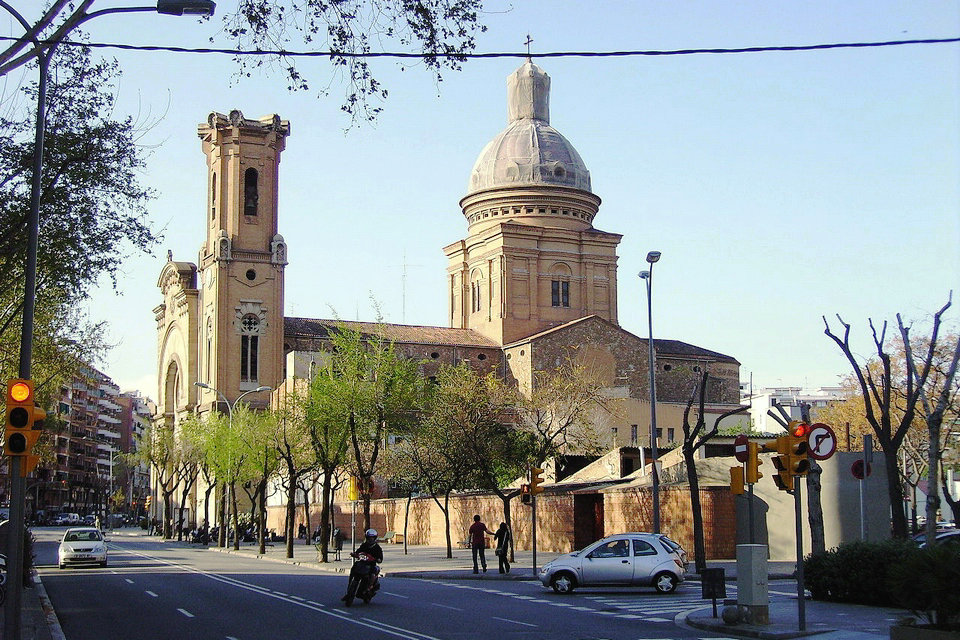
In the 10th century we find the first mention of the temple of Sant Andreu, which was assaulted and destroyed by Al-Mansur in 985. A new Romanesque church was built and consecrated in 1105 by Bishop Berenguer of Barcelona, it was again destroyed by the Almogavars and re-consecrated by Oleguer of Barcelona in 1132.
From this parish they left, the 8 of June of 1640, the reapers with the image of Santo Christ to protest against the virrey count of Santa Coloma, to whom they killed in the famous Corpus of Blood. In 1850 it was decided to expand it by commissioning the works from the Andreu architect Pere Falqués i Urpí, with an appearance between classicist and eclecticist. The bell tower integrated at the far right of the main façade and the 68 m high quadrangular dome are the two most outstanding elements of its appearance.
During the Tragic Week of 1909 and then during the Civil War of 1936 there were serious fires again, which destroyed especially the interior decoration. Between 1954 and 1960 the local painter Josep Verdaguer was in charge of painting the murals, representing the life of Sant Andreu and biblical scenes.
Parish of Saint Pacià
Made by the architect Joan Torras i Guardiola and inaugurated in 1881, it is in neo-Gothic style, with a single nave and a roof with ribbed pointed arches. The windows are also of Gothic aesthetics, and all of them look very sober. Caught fire during the Tragic Week of 1909. He returned to worship in 1922, when the bell tower was built. The floor mosaic was designed by Antoni Gaudí and was restored in 1988 by Lluís Bru i Borrell. In 1985 the sculptor Medina Ayllón carved a Risen Christ for the apse, on the mural by the painter Eduald Serrasolses de Sant Andreu.
Cultural space
Can Fontanet – Interpretation Center of the Three Tombs
Can Fontanet is a site of the Fabra i Coats company built in 1917, which formerly housed carts and horses and served the spinning mill. It is currently the Interpretation Center of the Three Tombs, with objects and information related to this festival: carts, panels, trimmings for horses and a room for audiovisual projections. A major refurbishment has turned the old Can Fontanet building, a building attached to the Fabra i Coats spinning mill, into the only Interpretation Center for the Three Tombs of Catalonia. The original space maintains the modernist entrance for carriage traffic, and consists of a stable for four horses, a permanent exhibition of carriages with images and historical explanations, the recreation of an old blacksmith’s oven and an exhibition space. and conference room. The festivities of the Three Tombs are celebrated all over Catalonia on the occasion of the feast of Sant Antoni Abat, protector of animals, around 17 January. The main rite is to go around three times with horses, carts and other draft animals inside the town; is called the Three Tombs.
Municipal Center of Popular Culture of Sant Andreu
This wide single-storey building is a public facility aimed at promoting and disseminating the traditional culture of Catalonia and becomes a clear example of the strength of the associative fabric in the district. It has several spaces for community use and is located between Carrer d’Arquímedes and Plaça de Can Galta Cremat, which was the name of the factory that used to be there. Since 2006, the Sant Andreu district has had a facility dedicated entirely to popular culture, the first to be built in the city of Barcelona with these characteristics. It is the headquarters of entities such as the Coordinadora de Trabucaires de Catalunya and the Federació Catalana dels Tres Tombs.
Sant Andreu Civic Center
Community face-to-face activities suspended. Courses and workshops are done online or in person. Cultural programming is maintained. The Sant Andreu Civic Center turns one of the most traditional areas of the neighborhood into a space for citizen participation. Specializing in the visual and performing arts, the venue, where the great activity of the neighborhood is concentrated, promotes culture through activities, courses and exhibitions. In the past, there was a textile factory in the space, which was used as garages and as a workshop. Before 1874, on the land now occupied by the Civic Center, there was the Can Balsells textile factory. In 1877, the old factory was used as a depot and repair shop for the Tramvia de Foc, the first tramway to connect the center of Barcelona with Sant Andreu. The birth of trolleybuses turned the tram depots into a transformer station until 1960.
Sant Andreu Theate
Better known as SAT., the Sant Andreu Teatre offers a wide and varied family program based on fun, education and artistic quality with the aim of disseminating the performing arts. It also has a school campaign for the training of boys and girls. The enclosure, with pending platforms and a great visibility and acoustics, occupies a ship of the street of Neopatria. It is located in an old bus depot. In 2003, it became a new theater. Specializing in family theater and for schools, it has become a point of reference in the city of Barcelona in terms of shows for children.
Parks and gardens
Sant Andreu offers plenty of outdoor spaces ideal for strolling and enjoying nature and the landscape. The green spaces of the district are closely linked to the canals and the distribution of water and, therefore, to the foundation, growth and transformation of the old town of Sant Andreu de Palomar. Explore the nooks and crannies of the area’s parks and gardens and discover the history behind them.
Festa Major de Sant Andreu de Palomar
The Festa Major de Sant Andreu de Palomar is celebrated between the end of November and the beginning of December in the Sant Andreu de Palomar district, in the Sant Andreu district of Barcelona. The fact that it was an old town gives Sant Andreu a very marked identity of its own, which is expressed in the maintenance of many traditions and, above all, in the main festival. The neighborhood has a good string of centuries-old entities, such as the Catalanists Cultural Center or the Casal Catòlic de Sant Andreu. When the festival arrives, most associations and entities are very actively involved in the organization of all kinds of cultural, leisure and sports events.
The starting point of the main festival of each year is the Esclat Andreuenc, a festive sample of the popular culture of the neighborhood, in which the giants, the trabucaires, the devils and the dancers of the Esbart Maragall participate. This entity also organizes the Sant Andreu Dansa show, where the dances of all the sections are exhibited. The gangs of devils of Sant Andreu, which have always been numerous in the neighborhood, come together to organize the correfocs.
Saint Andrew the Apostle is the patron saint of the parish around which the first population center originated in the 11th century, a festival that is celebrated on 30 November. Over the years, the name remained, but that eminently rural population became a working-class and artisan village in the nineteenth century. The name Palomar comes from the large number of dovecotes that once existed in the town.
Esclat Andreuenc.
On the first day of the festival, the Brotherhood of Trabucaires, Geganters and Grallers de Sant Andreu organizes this exhibition of popular culture. In addition to the trabucaires and giants, there are more organizations in the neighborhood, such as the dancers of the Esbart Maragall or gangs of devils. It all starts with a parade, then there is a parade and culminates with the final dances.
Wake up.
On the Sunday of the main festival, the residents wake up early to inform them that the big day has arrived. In Sant Andreu the awakening is threefold, because the grallers and trabucaires of the Brotherhood and the devils of the Satanic of Sant Andreu take part. The groups gather early in Orfila Square and from there they spread out through the streets of the neighborhood to make noise with blunderbusses, grallas and firecrackers.
Giant parade.
The giants of Sant Andreu, Andreu and La Colometa, are the hosts of one of the most successful giant parades in the city. It usually takes place on the Sunday of the main festival and is very busy, because it is the last outing of the giant season in Barcelona.
Sant Andreu Dance.
The Esbart Maragall is a historical dance promotion organization founded in 1931. Every year for the main festival it organizes a dance festival where all the sections of the organization are exhibited.
Correfoc.
Sant Andreu has a long tradition of devil gangs and for this reason the correfoc has always been a prominent event in the program of the festival. There are currently two very active ones in the neighborhood: the Satanic of Sant Andreu and the Devils of the Infernal Mercadal that organize, respectively, the adult and children’s correfoc.