Roybon, Isere, Auvergne-Rhône-Alpes, France

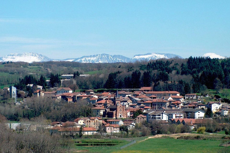
Roybon is a French commune located in the department of Isère, in the Auvergne-Rhône-Alpes region and, formerly attached to the former province of Dauphiné. Historically the city of Roybon was created in xiv th century following the signing of a charter granted by Humbert 1 st, Dauphin Viennese granting the “right to albergement” to anyone who would settle in the forest clear it. The first encampments were made around a source where “the rif (the rû) was good” and whose nickname would be at the origin of the name of the village.
The Municipality of Roybon located between the Plaine de Bièvre to the north, the Isère valley to the south-east, the valley of Rhône to the west. Geographically, the territory of the town of Roybon is very extensive and covers a good part of the Chambaran plateau in the west of the department of Isère and whose territory is the subject of a holiday center project, including the construction a holiday village and a water park, located in the middle of the forest.
History
Following the transfer of the Dauphiné to the crown of France in the middle of the 14th century, and an exchange of lands between the families of Savoy, Geneva and the King of France, the seigneury of Roybon became a land of the counts of Geneva, then, by marriage, of the Marquis de Saluces. In fact, the Count of Geneva married Béatrix de Saluces and, on her death, the land of Roybon entered the Saluces family, probably before 1370. Around 1398, Cardinal Amédée de Saluces became its lord, until upon his death in 1419.
His nephew, Bertrand, then inherited it but was unfortunately killed at the battle of Verneuil-sur-Avre (*), which opposed the French and the Scots to the English and the Burgundians in 1424. The land of Roybon was then administered by the representatives du Dauphin de France, for three years, before returning to the Saluces family in 1427. Louis I of Saluces was then the lord from 1428 to 1475. His son Louis II succeeded him shortly and sold the lordship in 1480 for pay a debt to his sister Marguerite. The seigneury will therefore remain in the Saluces family for practically the entire 15th century. On the other hand, the Saluces did not remain in the modest castle of Roybon, but rather in the barony of Anthon or in Saint-Donat, and entrusted the administration of their lands to the lords.
Saluzzo was the seat of the Marquises of Saluces from 1142 to 1548. Gian Gabriele I of Saluzzo died without heirs in 1548 and the Marquisate was then attached to France. In 1601, the Duke of Savoy Charles-Emmanuel I the Great obtained from Henri IV to attach the marquisate to the House of Savoy during the peace of Lyon.
It is from this period under French domination that the city also bears the French name of Saluces. There are many traces of this francization still today, for example on the pediment of the casa cavassa now transformed into a museum where you can read the motto “right whatever”.
The site is famous geologically because it is a privileged place of observation of ophiolites, rocks of the oceanic crust at the origin of the formation of the Alps. The spectacular pillar of Mount Viso is made of metamorphosed basalt and gabbros. Lower down, the slopes of Mount Viso were the site of a Neolithic jade quarry, between 2,000 and 2,400 meters above sea level. Its peak of exploitation is estimated at -5000 BC. Jadeite was used to make ceremonial axes, which can be found throughout Western Europe.
Not far from the slopes of the Viso is the Pertuis du Viso, under the Col de la Traversette: it is the first tunnel dug under the Alps, at the end of the 15th century. This work was produced on the initiative of Ludovico II, Marquis of Saluces, to link Provence and the Dauphiné to his marquisate. Completed in 1480, after two years of work, it was sized to allow the passage of a pack-mule and a bent man. Take it to avoid crossing the Col de la Traversette, at an altitude of 2947 meters. Economically, it reduces the journey from Grenoble to Saluces by three days, avoiding the Duchy of Savoy which then controls the Mont-Cenis pass, which promotes trade. The caravans connecting Provence to Turin save up to three weeks compared to the southern route which takes the Montgenèvre pass.
In 1953, the Council decided to deal with a nurseryman from Saint-Lattier for a market of 700,000 Francs at the time including the planting of 18,000 trees. The work is done and 490,000 Francs are paid after provisional acceptance of the work. But on May 9, 1956, after final acceptance of the work, it turned out that the plantation was faulty, that the first maintenance work had not been properly carried out, the trees having only recovered to the extent of 45%. instead of the usual 80% in this kind of work. A report is therefore drawn up by the Water & Forest administration and the Municipal Council decides that the remaining sum to be paid (210,000 Francs) will be used to protect and clear the remaining plants. It was therefore in 1956 that urgent work to safeguard these young plants was carried out, thus marking the real birth of this forest, which would quickly be called “la Sapinière”.
After having been an adult and having celebrated its half-century of existence, the forest of the “Sapinière” was cleared over two periods: the northern part was cleared in 2005 to leave the land free for the construction of the new school group and the southern part was cleared shortly after to accommodate the future extension of the village as part of the Local Urban Planning Plan validated in the fall of 2007.
Today, the Municipality seeks to maintain the population, even to make it progress. To this end, municipal action is focused on maintaining existing activities and developing new activities. Certain actions have already made it possible to offer residents services or infrastructures which were lacking or which were insufficient (construction of a new school, a library, renovation of the Tourist Office, major renovation work). safety at the lake, maintenance of a road network in good condition, development of crossroads and squares, etc.).
Project of a leisure park
In 2007, Center Parcs Europe, a subsidiary of the Pierre & Vacances-Center Parcs group, launched a project to build a holiday village under the Center Parcs brand, in the Avenières woods, on the heights of Roybon. This new domain, named Forêt de Chambaran, will include, among other things, 1,000 cottage s over an area of 203 ha.
The construction of this vast tourist complex began in november 2014and should have been completed in 2017. This project meets the opposition of various associations for the protection of nature and the environment, the harmful impact of this future tourist complex on the environment of this wooded area and its wetland.
Culture heritage
The remains of the urban wall from the Middle Ages.
The Louis XI pavilion.
The houses in rollers (xviii th and xix th centuries)
The former castle of Loives and dungeon (4 th quarter of the xiv th century), possession of Dolphins Viennese, today center of a farm classified as a historical monument by order of March 8, 1961(Loives farm).
The Saint-Romme castle.
The pebble in town hall (xix th century).
The St. John the Baptist Romanesque Revival built in the second half of the xix th century rollers arranged in edge-of-fish alternating with brick row by architect Alfred Berruyer; pulpit, tabernacle.
Roybon’s Statue of Liberty. This monument was erected on September 22 and 23, 1906 in honor of Henri Saint-Romme (1797-1862), one of the main figures of the Second Republic in the department of Isère. This statue represents a faithful replica, in cast iron, of the Statue of Liberty of New York. Three meters high, it would fit entirely, with its base, in the hand of its elder. It was bequeathed by Auguste Bartholdi to his friend Mathias Saint-Romme who made it a symbol for his father’s monument. The “Liberty of Roybon” was sunk in 1903. On the pedestal is affixed a bronze bas-relief representing Henri Saint-Romme, the work of the sculptor Auguste Davin.
The Notre-Dame-du-Sacré-Cœur Abbey of Chambaran, Cistercian, neo-Romanesque 1931.
Natural heritage
The national forest of Chambaran (7,300 ha), comprising a rare flora and numerous ponds;
The Chambaran natural park (240 ha), within the Chambaran forest.
Roybon lake and the leisure center
The artificial lake was formed by building a dike dam on the Aigue-Noire river. 400 m long and 100 m wide, it is suitable for swimming and fishing. The associated recreation area allows picnics, family outings and relaxation. The Bar du Lac is open during the summer and offers visitors refreshments and snacks.During 2012, a new weir was built for safety reasons. The Municipality took advantage of the emptying of the lake to carry out a total cleaning of the bottom of this one and to arrange a footpath on the east bank which was until then hardly accessible. A pedestrian path will eventually make it possible to circle the entire lake.