
A reservoir is, most commonly, an enlarged natural or artificial lake, pond, or impoundment created using a dam or lock to store water. Reservoirs can be created in a number of ways, including controlling a watercourse that drains an existing body of water, interrupting a watercourse to form an embayment within it, through excavation, or building any number of retaining walls or levees. Defined as a storage space for fluids, reservoirs may hold water or gasses, including hydrocarbons. Tank reservoirs store these in ground-level, elevated, or buried tanks. Tank reservoirs for water are also called cisterns. Most underground reservoirs are used to store liquids, principally either water or petroleum, below ground.
The state of California has a large number of reservoirs. Many, though not all, of these are publicly accessible in parks and recreation areas, and these lakes contribute significantly to the state’s beauty, as many of them are set in the Diablo Range and the Sierra Nevada.
Understand
California’s climate is Mediterranean, with most rain and snow falling in winter across much of the state; and in many populated regions such as Sacramento and the Bay Area, summer precipitation is almost unheard of, while winter precipitation is abundant. Therefore reservoirs are necessary to support California’s large and rapidly growing population throughout the year.
Winter precipitation, which falls as snow in the Sierra Nevada and as rain in the Diablo Range, accumulates into rivers and creeks in canyons and valleys. Rivers flowing from the Sierra Nevada ultimately lead to the San Joaquin Valley and from there to the Sacramento Delta, while those from the Diablo Range drain into the San Francisco Bay via the Alameda and Coyote Creeks. City governments such as those in San Francisco and Los Angeles recognized the need for water and, despite environmental concerns, built dams (therefore forming reservoirs) on these rivers and creeks for the purpose of water storage. Complex underground canals, such as the Hetch Hetchy Aqueduct, along with canals in the Central Valley, brought water from the new rural reservoirs to major cities. One of the most beautiful valleys in the U.S., Yosemite Valley’s neighbor and former twin Hetch Hetchy was one of the most significant casualties of this surge in development, and today the valley has been replaced by a reservoir, although the scenery around the lake remains picturesque.
Increased urbanization of the south and western portions of the state, along with suburban sprawl surrounding the state’s capital, caused the construction and expansion of existing reservoirs to continue, and there are few signs that the trend will end as the state’s population continues to expand rapidly. Unfortunately, many canyons and valleys are no longer to be found, but in many places this has been compensated with the creation of recreation areas surrounding the reservoirs, and activities such as boating and fishing have become possible in previously dry riverbeds and temporary streams. (In the case of Los Vaqueros Reservoir, for example, water supply is not from the nearby dry canyons, but instead from the Sacramento Delta, which has a varying level of salt content. The lake/reservoir itself is ironically in a semi-desert.)
Since the depth of canyons and mountain valleys makes these places ideal locations for reservoirs, California’s reservoirs are found in mountain ranges or the foothills of them. The abundance of remote canyons within the Diablo Range, along with the great depth of the Sierra’s canyons, valleys, along with more canyons within the foothills, has concentrated reservoirs in these areas. It would be an impossible task to list all California’s reservoirs (there are so many of them), but some of the large and particularly beautiful of them are included here.
Some of them are additionally significant for historical and/or meteorological context, such as Lake Oroville, which surpassed its maximum capacity due to high precipitation during a wet season, while others during the 2010s drought ran almost completely dry. Despite the fact that droughts and floods must have caused headaches for engineers and government officials throughout the many natural disasters of the state’s history, many of these events’ impacts and the stories of such events have been largely forgotten (with the exception of the Lake Oroville incident), and incidents that ought to be better-known may now be marked with nothing more than an inconspicuous plaque beside a flooded building.
Types
Dammed valleys
A dam constructed in a valley relies on the natural topography to provide most of the basin of the reservoir. Dams are typically located at a narrow part of a valley downstream of a natural basin. The valley sides act as natural walls, with the dam located at the narrowest practical point to provide strength and the lowest cost of construction. In many reservoir construction projects, people have to be moved and re-housed, historical artifacts moved or rare environments relocated. Examples include the temples of Abu Simbel (which were moved before the construction of the Aswan Dam to create Lake Nasser from the Nile in Egypt), the relocation of the village of Capel Celyn during the construction of Llyn Celyn. and the relocation of Borgo San Pietro of Petrella Salto during the construction of Lake Salto.
Construction of a reservoir in a valley will usually need the river to be diverted during part of the build, often through a temporary tunnel or by-pass channel.
In hilly regions, reservoirs are often constructed by enlarging existing lakes. Sometimes in such reservoirs, the new top water level exceeds the watershed height on one or more of the feeder streams such as at Llyn Clywedog in Mid Wales. In such cases additional side dams are required to contain the reservoir.
Where the topography is poorly suited to a single large reservoir, a number of smaller reservoirs may be constructed in a chain, as in the River Taff valley where the Llwyn-on, Cantref and Beacons Reservoirs form a chain up the valley.
Coastal
Coastal reservoirs are fresh water storage reservoirs located on the sea coast near the river mouth to store the flood water of a river. As the land based reservoir construction is fraught with substantial land submergence, coastal reservoir is preferred economically and technically since it does not use scarce land area. Many coastal reservoirs were constructed in Asia and Europe. Saemanguem in South Korea, Marina Barrage in Singapore, Qingcaosha in China, and Plover Cove in Hong Kong, etc are few existing coastal reservoirs.
Bank-side
Where water is pumped or siphoned from a river of variable quality or size, bank-side reservoirs may be built to store the water. Such reservoirs are usually formed partly by excavation and partly by building a complete encircling bund or embankment, which may exceed 6 km (4 miles) in circumference. Both the floor of the reservoir and the bund must have an impermeable lining or core: initially these were often made of puddled clay, but this has generally been superseded by the modern use of rolled clay.
The water stored in such reservoirs may stay there for several months, during which time normal biological processes may substantially reduce many contaminants and almost eliminate any turbidity. The use of bank-side reservoirs also allows water abstraction to be stopped for some time, when the river is unacceptably polluted or when flow conditions are very low due to drought. The London water supply system is one example of the use of bank-side storage: the water is taken from the River Thames and River Lee; several large Thames-side reservoirs such as Queen Mary Reservoir can be seen along the approach to London Heathrow Airport.
Service
Service reservoirs store fully treated potable water close to the point of distribution. Many service reservoirs are constructed as water towers, often as elevated structures on concrete pillars where the landscape is relatively flat. Other service reservoirs can be almost entirely underground, especially in more hilly or mountainous country. In the United Kingdom, Thames Water has many underground reservoirs, sometimes also called cisterns, built in the 1800s, most of which are lined with brick. A good example is the Honor Oak Reservoir in London, constructed between 1901 and 1909. When it was completed it was said to be the largest brick built underground reservoir in the world and it is still one of the largest in Europe. This reservoir now forms part of the southern extension of the Thames Water Ring Main. The top of the reservoir has been grassed over and is now used by the Aquarius Golf Club.
Service reservoirs perform several functions, including ensuring sufficient head of water in the water distribution system and providing water capacity to even out peak demand from consumers, enabling the treatment plant to run at optimum efficiency. Large service reservoirs can also be managed to reduce the cost of pumping, by refilling the reservoir at times of day when energy costs are low.
Reservoirs
Folsom Lake Folsom Lake is near — as its name implies — the city of Folsom, which is in turn northeast of Sacramento, the state capital; the dam can be seen from one of the local roads.
Hetch Hetchy Hetch Hetchy is north of Yosemite Valley, in Yosemite National Park. Once a valley not so different from its southern neighbor, it’s now the location of a long, fairly narrow reservoir alongside which there’s a hiking trail. The Hetch Hetchy Aqueduct runs underground toward the San Francisco Bay Area.
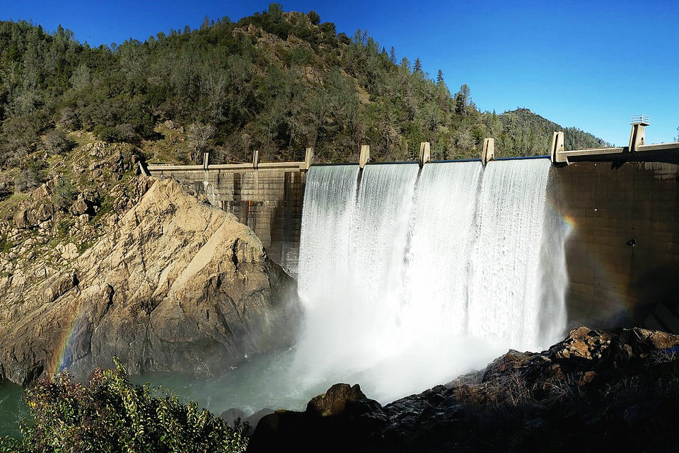
Lake Clementine Lake Clementine near Auburn is a moderately sized reservoir in that region’s deep, narrow canyons. Upstream from an extremely high bridge, a trail and road go to the reservoir, the trail going directly underneath the bridge, although the dam (pictured in banner) is spectacular in itself.
Lake Del Valle Lake Del Valle is surrounded by Del Valle Regional Park, which is dominated by hills in the north — which overlook cliffs, golf courses, vineyards, and of course the lake — and mountains covered with pine woodlands to the south. There are two entrances to the park, one in the north, from which you must hike to the the top of the ridge to the see the lake, and another in the south, which goes directly to the lake’s southern end. Arroyo Del Valle flows into the lake from this end, though the stream’s water level is inconsistent. There are some campsites at the southern end of the park.
Lake McClure and 6 Don Pedro Reservoir Don Pedro Reservoir are in the Sierra Nevada foothills.
Lake Nacimiento Lake Nacimiento is close to its neighbor the Lake San Antonio Lake San Antonio, not to be confused with the other San Antonio Reservoir, also a reservoir, in the East Bay. Lake Nacimiento is large and beautiful, yet in a fairly remote location not too far from Paso Robles. Apart from its nearby twin, which went almost completely dry during the 2010s drought, there are few important points of interest in the area; it’s really one of California’s “hidden gems.” The lake’s shape, when viewed on a map, resembles that of a dragon.
Lake Oroville Lake Oroville is famous for exceeding its maximum capacity during flooding the 2010s as a result of a particularly wet rainy season. The emergency spillway was used and thousands of residents of nearby Oroville were evacuated. The lake itself is one of the larger reservoirs in the Sierra foothills.
Los Vaqueros Reservoir Los Vaqueros Reservoir entered the “big league” of reservoirs in the early 2010s when its dam was raised to accommodate a larger reservoir, and the marina and some trails were moved for the sake of these changes, which were put into practice to bring more water to Contra Costa County. The west side of the lake, and the region to the north of it, are part of a preserve, and there are miles of hiking, though some trails away from the lake are rather remote. To the south is the giant Altamont Pass Wind Farm, while to the east of the lake are the Vasco Caves, which contrary to their name consist more of rocky terrain than actual caves.
San Luis Reservoir San Luis Reservoir in the eastern foothills of the Diablo Range is a large lake surrounded by the golden hills of the western edge of the Central Valley, southeast of the Bay Area and east of Gilroy.
Shasta Lake Shasta Lake is near Mount Shasta, one of the state’s highest mountains, at the northern end of the Central Valley were the Coast Ranges meet the Cascades.
Uses
Direct water supply
Many dammed river reservoirs and most bank-side reservoirs are used to provide the raw water feed to a water treatment plant which delivers drinking water through water mains. The reservoir does not merely hold water until it is needed: it can also be the first part of the water treatment process. The time the water is held before it is released is known as the retention time. This is a design feature that allows particles and silts to settle out, as well as time for natural biological treatment using algae, bacteria and zooplankton that naturally live in the water. However natural limnological processes in temperate climate lakes produce temperature stratification in the water, which tends to partition some elements such as manganese and phosphorus into deep, cold anoxic water during the summer months. In the autumn and winter the lake becomes fully mixed again. During drought conditions, it is sometimes necessary to draw down the cold bottom water, and the elevated levels of manganese in particular can cause problems in water treatment plants.
Hydroelectricity
In 2005, about 25% of the world’s 33,105 large dams (over 15 metres in height) were used for hydroelectricity.The U.S. produces 3% of its electricity from 80,000 dams of all sizes. An initiative is underway to retrofit more dams as a good use of existing infrastructure to provide many smaller communities with a reliable source of energy. A reservoir generating hydroelectricity includes turbines connected to the retained water body by large-diameter pipes. These generating sets may be at the base of the dam or some distance away. In a flat river valley a reservoir needs to be deep enough to create a head of water at the turbines; and if there are periods of drought the reservoir needs to hold enough water to average out the river’s flow throughout the year(s). Run-of-the-river hydro in a steep valley with constant flow needs no reservoir.
Some reservoirs generating hydroelectricity use pumped recharge: a high-level reservoir is filled with water using high-performance electric pumps at times when electricity demand is low, and then uses this stored water to generate electricity by releasing the stored water into a low-level reservoir when electricity demand is high. Such systems are called pump-storage schemes.
Controlling watersources
Reservoirs can be used in a number of ways to control how water flows through downstream waterways:
Downstream water supply – water may be released from an upland reservoir so that it can be abstracted for drinking water lower down the system, sometimes hundred of miles further downstream.
Irrigation – water in an irrigation reservoir may be released into networks of canals for use in farmlands or secondary water systems. Irrigation may also be supported by reservoirs which maintain river flows, allowing water to be abstracted for irrigation lower down the river.
Flood control – also known as an “attenuation” or “balancing” reservoirs, flood control reservoirs collect water at times of very high rainfall, then release it slowly during the following weeks or months. Some of these reservoirs are constructed across the river line, with the onward flow controlled by an orifice plate. When river flow exceeds the capacity of the orifice plate, water builds up behind the dam; but as soon as the flow rate reduces, the water behind the dam is slowly released until the reservoir is empty again. In some cases, such reservoirs only function a few times in a decade, and the land behind the reservoir may be developed as community or recreational land. A new generation of balancing dams are being developed to combat the possible consequences of climate change. They are called “Flood Detention Reservoirs”. Because these reservoirs will remain dry for long periods, there may be a risk of the clay core drying out, reducing its structural stability. Recent developments include the use of composite core fill made from recycled materials as an alternative to clay.
Canals – Where a natural watercourse’s water is not available to be diverted into a canal, a reservoir may be built to guarantee the water level in the canal: for example, where a canal climbs through locks to cross a range of hills.
Recreation – water may be released from a reservoir to create or supplement white water conditions for kayaking and other white-water sports. On salmonid rivers special releases (in Britain called freshets) are made to encourage natural migration behaviours in fish and to provide a variety of fishing conditions for anglers.
Flow balancing
Reservoirs can be used to balance the flow in highly managed systems, taking in water during high flows and releasing it again during low flows. In order for this to work without pumping requires careful control of water levels using spillways. When a major storm approaches, the dam operators calculate the volume of water that the storm will add to the reservoir. If forecast storm water will overfill the reservoir, water is slowly let out of the reservoir prior to, and during, the storm. If done with sufficient lead time, the major storm will not fill the reservoir and areas downstream will not experience damaging flows. Accurate weather forecasts are essential so that dam operators can correctly plan drawdowns prior to a high rainfall event. Dam operators blamed a faulty weather forecast on the 2010–2011 Queensland floods. Examples of highly managed reservoirs are Burrendong Dam in Australia and Bala Lake (Llyn Tegid) in North Wales. Bala Lake is a natural lake whose level was raised by a low dam and into which the River Dee flows or discharges depending upon flow conditions, as part of the River Dee regulation system. This mode of operation is a form of hydraulic capacitance in the river system.
Recreation
Many reservoirs often allow some recreational uses, such as fishing and boating. Special rules may apply for the safety of the public and to protect the quality of the water and the ecology of the surrounding area. Many reservoirs now support and encourage less formal and less structured recreation such as natural history, bird watching, landscape painting, walking and hiking, and often provide information boards and interpretation material to encourage responsible use.
Operation
Water falling as rain upstream of the reservoir, together with any groundwater emerging as springs, is stored in the reservoir. Any excess water can be spilled via a specifically designed spillway. Stored water may be piped by gravity for use as drinking water, to generate hydro-electricity or to maintain river flows to support downstream uses. Occasionally reservoirs can be managed to retain water during high rainfall events to prevent or reduce downstream flooding. Some reservoirs support several uses, and the operating rules may be complex.
Most modern reservoirs have a specially designed draw-off tower that can discharge water from the reservoir at different levels, both to access water as the water level falls, and to allow water of a specific quality to be discharged into the downstream river as “compensation water”: the operators of many upland or in-river reservoirs have obligations to release water into the downstream river to maintain river quality, support fisheries, to maintain downstream industrial and recreational uses or for a range of other purposes. Such releases are known as compensation water.
Terminology
The units used for measuring reservoir areas and volumes vary from country to country. In most of the world, reservoir areas are expressed in square kilometres; in the United States, acres are commonly used. For volume, either cubic metres or cubic kilometres are widely used, with acre-feet used in the US.
The capacity, volume, or storage of a reservoir is usually divided into distinguishable areas. Dead or inactive storage refers to water in a reservoir that cannot be drained by gravity through a dam’s outlet works, spillway, or power plant intake and can only be pumped out. Dead storage allows sediments to settle, which improves water quality and also creates an area for fish during low levels. Active or live storage is the portion of the reservoir that can be used for flood control, power production, navigation, and downstream releases. In addition, a reservoir’s “flood control capacity” is the amount of water it can regulate during flooding. The “surcharge capacity” is the capacity of the reservoir above the spillway crest that cannot be regulated.
In the United States, the water below the normal maximum level of a reservoir is called the “conservation pool”.
In the United Kingdom, “top water level” describes the reservoir full state, while “fully drawn down” describes the minimum retained volume.
Modelling reservoir management
There is a wide variety of software for modelling reservoirs, from the specialist Dam Safety Program Management Tools (DSPMT) to the relatively simple WAFLEX, to integrated models like the Water Evaluation And Planning system (WEAP) that place reservoir operations in the context of system-wide demands and supplies.
Safety
In many countries large reservoirs are closely regulated to try to prevent or minimise failures of containment.
While much of the effort is directed at the dam and its associated structures as the weakest part of the overall structure, the aim of such controls is to prevent an uncontrolled release of water from the reservoir. Reservoir failures can generate huge increases in flow down a river valley, with the potential to wash away towns and villages and cause considerable loss of life, such as the devastation following the failure of containment at Llyn Eigiau which killed 17 people.(see also List of dam failures)
A notable case of reservoirs being used as an instrument of war involved the British Royal Air Force Dambusters raid on Germany in World War II (codenamed “Operation Chastise”), in which three German reservoir dams were selected to be breached in order to damage German infrastructure and manufacturing and power capabilities deriving from the Ruhr and Eder rivers. The economic and social impact was derived from the enormous volumes of previously stored water that swept down the valleys, wreaking destruction. This raid later became the basis for several films.