Ramatuelle is a French commune in the Var department, in the Provence-Alpes-Côte d’Azur region. It is located on the Côte d’Azur, near the Gulf of Saint-Tropez.
Located in Provence in the Var department, the territory of Ramatuelle is separated from the rest of the canton of Sainte-Maxime by an arc of wooded hills which make it an isolated watershed. This territory includes two coastal plains, a shore of more than 16 kilometers consisting of the vast beach of Pampelonne, other smaller beaches, and caps Camarat and Taillat (the latter half with the neighboring town of La Croix-Valmer). The village, typical of defensive hilltop sites, rises on a foothill of the hill of Paillas at an altitude of about 130 meters south of Saint-Tropez. It overlooks the Bay of Pampelonne and the wine-growing plain.
History
Ramatuelle’s territory was coveted by humans very early on and has had a relatively turbulent history. Excavations undertaken in several places have indeed allowed to find numerous vestiges proving a human presence since Prehistoric times. Before becoming this town renowned in particular for the beauty and the extent of its landscapes, Ramatuelle crossed the centuries and millennia to build its own history.
Ramatuelle lies near St-Tropez, Sainte-Maxime and Gassin. It was built on a hill to defend itself against enemies. The town was known in the Middle Ages as Ramatuella (derived from the Arabic ‘the mercy of God’) and was part of the area ruled by the Moors of nearby Fraxinet in the ninth and tenth centuries.
Middle Ages
In the ix th century, the region was occupied by the Saracens during sixties. They leave few architectural traces, but we may owe them some toponyms like the name of Ramatuelle (see Toponymy). The Saracens were driven out by Count Guillaume de Provence, known as the Liberator, and in 1056, the territory of Ramatuelle was ceded to the Abbey of Saint-Victor in Marseille, which undertook the reconstruction of the village. The remains of the wall currently visible date from this period.
The war of the Union of Aix is a period of unrest for the village where from 1389 to 1399, the region experienced devastation and looting by the troops of Raimond de Turenne, known as the Scourge of Provence.
In the xv th century, the inhabitants of the region, frightened by the incursions of Barbary, are hiding in the hills in order to protect against pirate attacks and to scrutinize off the boats approaching the coast.
Renaissance
During the wars of religion, Ramatuelle is a stronghold of the Catholic league of the Count of Carcès who opposes the legitimacy of the “Protestant” king Henry IV. The village was besieged in 1592 by the militia of Saint-Tropez which razed the village. It is reported that the villagers short of ammunition, threw beehives faithful attackers King.
In 1620, the village was completely rebuilt, only a few elements of the wall, including the Saracen door and the bell tower of the church which is an old watchtower, date before the reconstruction.
Modern Period
Until 1855, the structure of the village seems unchanged for two centuries, with a village built concentrically on the heights and densely populated, while the plain remains almost virgin of construction, with the exception of a few barns. Then the village develops by public infrastructures (town hall, housing estates, school, roads…). From the beginning of the xx th century, profound socio-cultural changes taking place. Polyculture gives way to intensive cultivation of the vine and tourism is developing.
Contemporary period
During the Second World War, the region was successively occupied by the Italians and then the Germans. A group of Ramatuellist resistants stands out in particular by ensuring the exfiltration of special agents landed from the submersible Casabianca from Algiers. Pampelonne beach is at the heart of the landing of Provence, the hinterland is deeply devastated to allow the installation of a military base, including an airstrip. After the war, it will take several years to clear the beach, restore the roads and restore the vineyards.
In the second half of the xx th century, the urbanization of the plain explodes, including the construction of secondary homes.
Tourism
Tourism in Ramatuelle is mainly due to its natural attractions, the possibilities of leisure and entertainment and a cultural offer. The reputation of the town is linked to that of Pampelonne beach.
Several hotel establishments are located in the commune: 376 rooms in 14 hotels; 2,635 locations in 7 campsites. In addition, around 75% of the 3,490 dwellings in the municipality are second homes.
Architectural heritage
The municipality has several heritage elements:
The dolmen of Cape Taillat, dating from -2000 BC. AD,
the Saracen door of the xvi th century,
The lighthouse at Cape Camarat,
The barracks Customs Cape Taillat, dating from the xix th century,
Merlier holiday village, Camarat lighthouse road (1959-1965) by the architects of Atelier de Montrouge in collaboration with Louis Arretche: 35 holiday homes,
The mills of Paillas and Pampelonne,
The Volterra Castle,
The castle of Saint-Amé,
Several scenes from the series Gendarme de Saint-Tropez were shot on Ramatuelle.
The village of Ramatuelle
The village of Ramatuelle rises on a buttress of the hill of Paillas, thus dominating the whole bay of Pampelonne and the agricultural plain, at an altitude of about 130 meters. Coiled on itself and unfolding in the shape of a snail from the heart of the village, it was built according to a circular security plan imposed by constraints of which the few traces still visible of the high walls constitute the heritage.
The architecture of the village core is typical of Mediterranean villages revealing porches, stairs, passageways, plots, narrow, stone-lined and flowery alleys, a church and its bell tower. Its craft, paint and primitive art shops, which open in old cellars dug out of the rock, attract a large number of curious visitors each summer.
The village of Merlier
The village of Merlier, rather a hamlet given its size, benefits from the Label “Remarkable Contemporary Architecture” awarded by the Ministry of Culture. It is important to mention that the Merlier villas were designed from the outset to present the qualities of “ bioclimatic ” buildings and therefore naturally comfortable without artificial air conditioning. Unfortunately, some initiatives by uninformed owners have altered these qualities in some cases (the lateral ventilation slots on the terraces have sometimes been eliminated, etc.). The site constitutes private property and is not open to the public.
Camarat lighthouse
Located on Cape Camarat, it is the second highest lighthouse in France, its light source being located at 129.80 meters above sea level. Commissioned since 1831, electrified in 1946 then automated since 1977, it is remote-controlled from the lighthouse on Ile de Porquerolles. This site offers a very wide panoramic point of view, dominating the bay of Pampelonne and that of Bonporteau.
Religious heritage
Ramatuelle has beautiful monuments including the Frauenkirche (the xvii th century), in a Provencal country style, a chapel Sainte-Anne (xvi th century), a wrongly gate called “Saracen” since it is the xviii th century and a mansion in the village center. The alleys and houses of the city center are very beautiful and very picturesque.
Sainte-Anne chapel
The Sainte-Anne chapel is the only one of four former chapels to have been spared. It is also called the chapel of the Brotherhood of White Penitents; brotherhood which gathers in the form of a secular association whose goal is piety. Its members take care of the poor and bury the dead. Built in the 16th century, long abandoned, it was restored during the nineteen hundred and sixty years. It adjoins the current cemetery. A religious service is celebrated there for the feast of Sainte-Anne.
Environmental heritage
The town has many beaches including that, known, of Pampelonne. The site of Cap Camarat and Cap Taillat, protected by the coastal conservatory for the richness of its flora, is also in the commune of Ramatuelle.
In collaboration with the Ramatuelle town hall, the Var general council and the PACA regional council, the SIVOM marine observatory on the Maures coast was created in 1996. Located in the neighboring municipality of Cavalaire-sur-Mer, its objective is the management and observation of marine environments and their coastline.
The three caps Camarat
The three caps Camarat, Taillat and Lardier (the latter being located on the territory of La Croix-Valmer) are surrounded by the pedestrian path which offers 198 km of hikes on the Var coast. This former “customs officers’ path” indeed stretches out over sandy beaches, steep coves, processions of Mediterranean vegetation, pine forests.
Dolmen of Cape Taillat
Cape Taillat shelters a dolmen, “Dolmen of the Bay of Briande”, which is a burial dating from 2000 years before JC. Excavated in 1935, flint arrowheads, rock crystal pendants (hyaline quartz) and serpentine beads were found on this site. Recently restored, it is now empty of all content.
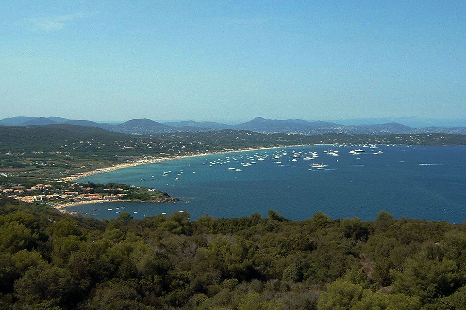
Pampelonne Beach
Pampelonne is today one of the most famous beaches on the planet. On a 4.5 km loop, it unrolls the charm of its fine sand. This space is visually limited to the South by Cape Camarat and Cape Bonne Terrasse, to the North by Cape Pinet, to the West by the vineyard, meadows, pines, canes of Provence and various tourist facilities (housing estates, campsites, car parks).
Pampelonne beach is the preferred location for activities linked to the beach, water sports and tourism in general. Its 27 hectares of fine sand welcome, every summer day between 20,000 and 30,000 users. Its beach establishments welcome the most prominent international personalities from the world of the arts, the economy or politics.
If this beach has managed to preserve, over the years, its identity, its setting of vines and greenery, it is thanks to the will of the municipalities that have succeeded each other in Ramatuelle. Moreover, since a judgment of the Council of State of November 13, 2002, the beach of Pampelonne is recognized as a “remarkable natural space” within the meaning of the law “Littoral”. However, the massive human attendance destabilizes this fragile site. The municipal team therefore undertook in 2001 the drawing up of a development plan for the entire beach and the back beach.
Escalet Beach
Located between Cap Camarat and Cap Taillat, this family beach stretches for about 350 meters. It continues in coves and beaches which are among the most beautiful landscapes of the Mediterranean coast.
Viticulture of Ramatuelle
The culture of the vine is an ancestral vocation for Ramatuelle. The Greeks already established the first stocks there 600 years before our era, then the Romans established large estates there and developed this culture. The wines produced were therefore the subject of intense trade.
Neglected and partially destroyed during the war years, the Ramatuellois vineyard had undergone a major renewal in 1945. High-yielding grape varieties were then adopted massively. But they produced low quality wines.
It was in 1946 that the appellation ” Côtes de Provence”»Receives its official status. Boosting all of the wine-making activity in this way, the estates existing on municipal territory provided their cellars with more efficient equipment, and some provided a bottling line. As for the small owners who could not make such investments, they regrouped and decided to create a wine cooperative in 1954, the first harvest of which dates back to 1956. Inaugurated on April 22, 1957, the cooperative wine cellar provided a powerful tool for many small farms which were able to master the technical development of cultivation, winemaking and marketing through a bottling chain.
In 1977, the Appellation d’Origine Contrôlée (AOC) label was recognized by the Côtes de Provence, thereby favoring the marketing of Ramatuelle wines, aided also by the reputation of the resort, the richness of the terroirs and the climates favorable to production. quality wines. Over the past thirty years, a major evolution in planting, production and winemaking techniques has made it possible to obtain an even wider range of wines.
French Riviera
The French Riviera is the Mediterranean coastline of the southeast corner of France. There is no official boundary, but it is usually considered to extend from Cassis, Toulon or Saint-Tropez on the west to Menton at the France–Italy border in the east, where the Italian Riviera joins. The coast is entirely within the Provence-Alpes-Côte d’Azur region of France. The Principality of Monaco is a semi-enclave within the region, surrounded on three sides by France and fronting the Mediterranean. Riviera is an Italian word that corresponds to the ancient Ligurian territory, wedged between the Var and Magra rivers.
The climate of the Côte d’Azur is temperate Mediterranean with mountain influences on the northern parts of the departments of Var and Alpes-Maritimes. It is characterized by dry summers and mild winters which help reduce the likelihood of freezing. The Côte d’Azur enjoys significant sunshine in mainland France for 300 days a year.
This coastline was one of the first modern resort areas. It began as a winter health resort for the British upper class at the end of the 18th century. With the arrival of the railway in the mid-19th century, it became the playground and vacation spot of British, Russian, and other aristocrats, such as Queen Victoria, Tsar Alexander II and King Edward VII, when he was Prince of Wales. In the summer, it also played home to many members of the Rothschild family. In the first half of the 20th century, it was frequented by artists and writers, including Pablo Picasso, Henri Matisse, Francis Bacon,h Wharton, Somerset Maugham and Aldous Huxley, as well as wealthy Americans and Europeans. After World War II, it became a popular tourist destination and convention site. Many celebrities, such as Elton John and Brigitte Bardot, have homes in the region.
The eastern part (maralpine) of the Côte d’Azur has been largely transformed by the concreting of the coast linked to the tourist development of foreigners from North Europe and the French,. The Var part is better preserved from urbanization with the exception of the agglomeration of Fréjus-Saint-Raphaël affected by the demographic growth of the maralpin coast and the agglomeration of Toulon which has been marked by urban sprawl on its part West and by a spread of industrial and commercial areas (Grand Var).