Pusignan is a French commune located in the Rhône department in the Auvergne-Rhône-Alpes region. The town of Pusignan is located 18 kilometers east of the city of Lyon and is part of the so – called East Lyonnais municipalities. In recent years, the proximity of Lyon has changed the appearance of the city. We built many houses. However, to preserve the quality of life, and to compensate for the constraints of the environment, it is forbidden to build buildings of more than two floors.
Pusignan owes its name to a lieutenant of Caesar, named – Pusinius. Burgundian tombs were found in Pusignan as well as traces of a Roman fort at a place called the Pavilion, which was a surveillance post and a military support point, because from there one could monitor the important trade route from Lyon to Crémieu. Built in the xii th century, the castle was destroyed in 1789. But the chapel still remains, and is today in the center of the old cemetery.
The hamlet of Moifond constitutes the original urban core dating from medieval times. Installed below the fortified castle on the crest of a hill, it has developed very little since that time. The real extension of Pusignan begins from the 19th century with the shift of the center of gravity of Moifond towards the old Roman road (current RD 517). The increase in trade will generate urbanization along this busy route. The focus of urbanization then developed around the Place de la Bascule (crossroads of East, West and North tracks), then spread to the West where the constructions were established up to the Place de la Gaité, thus constituting a village street.
Diffuse constructions are established between the two village cores, it is thus, that the Church and the Town hall are built in 1830. The urban extension, as in the majority of the communes of the outskirts of Lyon, takes importance from the 1960s. This strong growth is characterized by the development of residential subdivisions and business zones in several successive phases: initially, by grafts around the village-street mainly to the north of it, then in a second step, by a new shift towards the North, in particular with the creation of the Marriage and Bruyères activity zones in the North-East, finally, in a more recent period, by the emergence of small operations located in the South, on the less steep slopes of the hill, and in the North by the continuation of subdivision operations.
History
Once upon a time there was a small Gaulish village located on this hill of moraine origin. A few thatched houses comprising only one room, the comfort was relative, but we lived free, cultivating wheat, practicing breeding, hunting and gathering. Then came the Roman occupation. A fortified camp was established north of the hill overlooking the plain and controlling the road from Lugdunum to Crémiacum (in other words Crémieu). This military camp was commanded by a named Pusinius, Lieutenant of Caesar. Which led to suppose that he would have transmitted his name subsequently to the Bourgade.
Then, the Burgundians settled on the site. Later, at the beginning of the Middle Ages, a feudal motte was erected on the former site of the Roman camp; first wooden tower, then construction of pebbles, called old chatel. But over the centuries, this construction proved too modest to face quarrels with neighboring lords. Also, in the 12th century, the construction of a fortified castle was undertaken by the local lords, the “de Moifond”, an important fortification, dominating the plain to the south and the planaise forest. The enclosure was large enough to accommodate the peasants coming to take refuge there in the event of conflict.
Middle Ages
The years went by, and in 1389, King Charles VII gave the authorization to demolish the ancient “Vieux Chatel”.
In June 1430, the castle was involved in an event of very great importance, the future of Dauphiné. Indeed, Louis de Chalon, Prince of Orange, who enjoyed the confidence of his suzerain, the Duke of Burgundy, had decided to conquer the Dauphiné in order to link his domain of Franche Comté to his principality of Orange. The project was ambitious and would have given birth to an extremely powerful domain. Alix de Varax, owner of the Château de Pusignan, sided with the Prince of Orange and welcomed an Orange garrison.
The governor of Dauphiné, Raoul de Gaucourt, sensing the danger, asked for the help of the Senechal of Lyon, Humbert de Grolée. But, these, being aware of their numerical inferiority, then join the services of a formidable captain of truckers who camped in Vivarais: Rodrigue de Villandrando. The Dauphinois and their allies, guessing the imminent attack, took the initiative and seized the castles already occupied by the Orange troops: AUBERIVES – PUSIGNAN – AZIEU – COLOMBIER, with the exception of that of ANTHON still in the hands of the Orangemen. But in front of their numerical inferiority, it is cunning that is used. Louis de Chalon, with his impressive numerical superiority with his 4000 men, advances in peace to the aid of the Château de Colombier, of which he is unaware of the redemption.
He sets out on the Anthon-Colombier road which winds through the woods, where the 1,600 Dauphinois and allied fighters are in ambush in the thickets, near the village of Janneyrias. The Orange column, stretched out in the narrow path, is suddenly surprised on all sides.
The powerful Orange cavalry cannot maneuver and is trapped, the horses rear. Soon, it is the general confusion and saves him who can in Anthon’s direction. The fugitives abandon their weapons and baggage and escape through the woods. More than 200 men drown trying to cross the tumultuous Rhône. Only 300 horsemen had been able to escape with their mounts out of the 1,500 in the column.
The Prince of Orange owed his salvation only to the vigor and speed of his steed, on whom he succeeded, all bloodied, to cross the Rhone at Anthon. Two days later, 1,200 saddled and harnessed horses were sold in Crémieu. Thus ended the “Battle of Anthon”. The Dauphiné was saved.
King Charles VII confiscated the castle of Pusignan from Alix de Varax who had sided with the Prince of Orange and donated it to Rodrigue de Villandrando, whose courage had been decisive in the outcome of the fight. Rodrigue de Villandrando only lived for a short time in Pusignan with his troop, attracted by new adventures, but one can easily assume that the life of the villagers was not easy in contact with these dangerous neighbors.
Calm having returned, the castle was bought in 1450 by Aymar de Poisieu, nicknamed Cap Dorat because of his long blond hair. He had been Lieutenant of Joan of Arc and had distinguished himself at the siege of Orleans. He became the confidant of the Dauphin Louis II, future Louis XI, and negotiated the marriage of the latter with Charlotte of Savoy, born at Les Echelles.
In 1573, the descendants of Aymar de Poisieu sold the seigneury of Pusignan to François de Costaing, lord of the palace. His grandson Aymar de Costaing was a noted figure.
In 1620 he was 23 years old and was already in possession of a charge in the falconry of Louis XIII. Subsequently, he became Lieutenant General of the Grande Fauconnerie de France and frequently accompanied Louis XIII on his travels. Unfortunately, Aymar de Costaing did not have a descendant. Also, he established a will in favor of a nephew, Claude de Camus d’Arginy, on condition that he took the name and arms of the Costaing.
Claude de Camus d’Arginy, born around 1640, had a brilliant military career. He began as a cadet to the musketeers of Louis XIV and one can easily imagine the panache and the allure of the character evolving in this elite corps.
On the death of Aymar de Costaing in 1679, and in accordance with the conditions of the will drawn up by his uncle, Claude de Camus d’Arginy was henceforth called: Claude Costaing de Pusignan. He served in almost all of Louis XIV’s campaigns and commanded the regiments of Plessis Praslin and Languedoc.
In 1679, Louis XIV was to reward his loyal soldier by raising the seigneury of Pusignan to the marquisate, and was co-lord of Feyzin. In 1689, Louis XIV decided to help Jacques II of England to reconquer his throne by sending an expeditionary force to Ireland. Claude Costaing de Pusignan commanded the infantry with the title of Marshal of Camp. The ill-prepared expedition turned into a disaster. During an attack in front of Londonderry, a maritime town in the north of Ireland, Claude Costaing de Pusignan received a musket shot in the chest on May 5, 1689. Without care, lack of medication, and especially a surgeon, he died for 5 to 6 days and died around May 10 or 11. A great soldier had just passed away at the end of a glorious career.
We can still see traces of the funeral liter which was painted in his memory on the walls of the old church of Moifond, as well as in the church of Chassieu. Claude Costaing de Pusignan having died without posterity, the castle was sold on various occasions to fall last to Hugues Gautier de Mézia born in 1745. But, in the upheavals of a decadent royalty which had not known how to evolve, the great fear of 1789 made its appearance. A band of Dauphinois brigands came from Bourgoin, looted and burned the castles of Domarin, Vaulx Milieu, La Verpillière, and on July 28, that of Janneyrias.
Finally, came the turn of that of Pusignan. According to tradition, the inhabitants of Pusignan informed of what was happening, had decided to protect the castle by keeping guard. At the end of ten days, they starting to get tired, asked the Marquise to give them something to eat. This ill-inspired refused. The villagers, irritated by so little recognition, returned home. It was then that the Dauphinois brigands arrived in front of the castle of Pusignan. Some peasants joined them, looting the castle and setting it on fire.
Unfortunately all the archives, which could have given a lot of information on PUSIGNAN’s past, disappeared in the fire. The destruction of the castle was consumed by a purchaser of national property, who used it as a quarry, selling the stones to be used for new constructions.
Contemporary period
The destruction of the castle marked the end of an era and the beginning of a new era. The upheavals of the Revolution having subsided, peasant life was organized on new bases, after distribution of land and clearing of forests. An important agriculture developed: cereals, potatoes, then later sugar beets, as well as a very important cattle breeding whose milk and meat production found a natural outlet towards the city of LYON. A fairly large vineyard ensured the consumption of the villagers.
After the installation of a Chappe telegraph relay around 1820 at the top of the Ferraguet tower which is still visible, development accelerated and transformed village life. First harvesters in 1830, first threshing machine in 1850. Then, in 1881, an event of first importance, the commissioning of the Chemin de Fer de l’Est, between Lyon and Saint-Genis d’Aoste, allowing rapid and important connections for both travelers and goods.
Around 1890 the village had 1,400 inhabitants and had become an important center for breeding silkworms and weaving silk velvet. All the roads were lined with mulberry trees, the foliage of which was used as food for the caterpillars of the bombyx. Silkworm breeding courses were taught at school and each student had their own breeding ground at home, but silkworm disease decimated the farms and began the decline of the village. A quarter of the population went into exile between 1892 and 1893. Only the activity of the weavers remained, using some two hundred looms.
Finally came the tragedy of the 14/18 war. Women replaced, with exemplary courage, the men who had gone to the front, whether it was for work in the fields or to run the looms, while ensuring their role as mothers. Unfortunately, 51 men did not return, plunging forever into the distress of grieving families.
Around 1932, the Lyon silk crisis led to the end of the activity of many weavers, many of whom supplemented their meager income with small family farming.
Finally the Second World War sounded the death knell for weaving in PUSIGNAN. At the end of this dark and gloomy period, on August 31, 1944, PUSIGNAN was caught in the turmoil of the Liberation fighting and almost knew the fate of DORTAN and LAVANCIA, two towns in Ain, which were burnt down.
With peace found, the village looked resolutely towards the future. Agriculture diversified by adding to traditional cereal crops, quality market gardening.
Finally, the birth of two industrial zones allowed a modern development of the municipality. The creation of a Cultural and Sports Center of 3500 m², and numerous sports grounds, all allowing young people and all members of 35 associations to express themselves with dynamism.
PUSIGNAN, town of 3111 inhabitants, heir to a glorious past, cohabits with Satolas Airport and the TGV. It is resolutely turned towards the future while preserving its village character, at the foot of its old 12th century Church and the ruins of the feudal castle, from which a magnificent panorama extends from Pilat to Mont Blanc.
Historical heritage
In most villages in France, communal life is based on three traditional buildings: the TOWN HALL – the SCHOOL and the CHURCH. In PUSIGNAN, these three buildings are grouped together on the Place de la Mairie and perhaps it is interesting to know their history.
Over the centuries, the venerable 12th century Church, the only ancient monument still standing today, saw all the ceremonies taking place marking the important events, joyful or painful, marking out the different stages of the life of multiple generations.
The chapel
When you approach Moifond, the medieval district of PUSIGNAN, by the road to Saugnieu, a Romanesque steeple, square and squat, emerges above the communal cemetery. It is the bell tower of the old Church of the parish of PUSIGNAN. Romanesque in style, this cultural building probably erected in the 12th century depended, according to the cartularies, on the Abbey of Ile Barbe (founded by Charlemagne) and was intended to serve the town of Moifond, which was gradually formed on the land. of the seigneury of PUSIGNAN.
It is a modest-sized building (20 x 7 meters) with a single nave, but, complete, choir and apse on cross ribs, nave under a framework of a beautiful unity of style. It contains tombstones, including some from various members of the COSTAING family, lords of PUSIGNAN in the 17th century, archaic baptismal fonts and important remains of wall frescoes. In addition to the presbytery, the sacristy and a chapel adjoining the north face were demolished in 1858, after the construction of the current Church, with a view to enlarging the cemetery.
Its inclusion on the supplementary list of historical monuments had been requested by the municipality in 1977, it was definitively accepted on March 8, 1982. Fortunately, in the meantime, repairs to safeguard the building had been undertaken, financed by the municipality, helped by various subsidies. This is how all the door frames were redone in 1978. Then as a result of water infiltration, and maybe. vibrations due to the vicinity of Satolas airport, major work to consolidate the northern retaining walls of the choir and a total repair of the bell tower had to be undertaken. They were carried out by local companies, that of M. FOUT and that of M. BARBEREAU. During these repairs, by scraping the plasters, frescoes probably from the 14th century were discovered on the triumphal arch at the entrance to the choir.
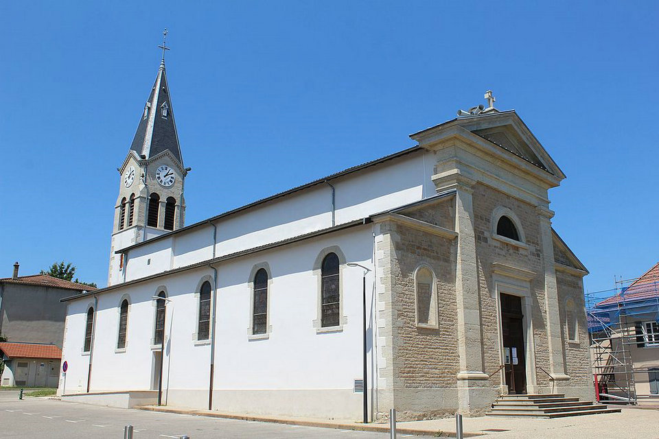
THE CHURCH OF MOIFOND
The old parish church located in the cemetery of Moifond, dates from the 12th century. It is the only Romanesque church in East Lyonnais still standing and represents an indisputable architectural exanple. Like any Romanesque Church, it is characterized in architecture by the semicircular arch, the thickness of the walls pierced under windows and supported on the outside by the buttresses. The Romanesque Church of Pusignan, of which only the Nave remains, was originally built according to the Roman model. The maintenance of the Nave was the responsibility of the parishioners, which explains its poor condition. That of the Choir by the Abbots of Ile Barbe “patron” of the Parish, through the Priory of Chavanoz.
On the facade we notice the presence of the monolithic lintel (a single block of stone above the opening of the central door) as well as the Arc des Charges. The windows of the Romanesque nave are fairly recent. Originally, there were very narrow windows whose purpose was to prevent the passage of men. These were enlarged in the 17th century. On the south facade of the Chapel we can notice a rest of the buttress. The bell tower is built on the span of the choir, which explains its width and its massive appearance dating from the 12th century. In the 16th century, it had 2 bells. in the 19th century, there was only one. It underwent modifications in its upper part at the end of the 15th century as well as the Apse (Choir). The choir window dates from the end of the Middle Ages. On the north facade of the Chapel we can notice the presence of green stones. They belong to the ice age of the Massif de Belledone (French Alps).
On the walls of the Nave and the Apse, there are traces of funeral liters. Originally the liters were painted on fabrics, but at the end of the 16th century, it was common to replace them with paintings (illustrating the memory of the deceased) much more resistant
These liters corresponded to a right that the Lord had for his funeral. It is assumed that the first liter – of which only a few traces remain – is that of Aymar de Costaing, who died in1679. The second – a little better preserved – belongs to Claude de Costaing who was killed during the battle of Londonderry, in Ireland, in 1689 under Louis XIV. We find this restored liter in the Church of Chassieu, this one depending on the same seigneury. On the liter we can still see the Coat of arms which reads: Azure on the face raised Argent accompanied by ten golden diamonds, four chiefly gnawed and six pointed placed 4 and 2.
In the Nave, there are a number of tombs. Only one is identifiable, that of Catherine de Bressac, wife of Hugues Gaultier de Mézia, last Lord of Pusignan, who died on October 8, 1773.
Restoration
In 1836, a restoration project began, but given the importance of the work to be undertaken, the Church becoming too small, it faded away in favor of the construction of a new Church in La Valla. In the choir still remains the harmonium which was used to store the archives of the Church as well as the liturgical pool. These movements of the various structures had for origin the disappearance of the presbytery, the sacristy and the chapel, side buildings whose demolition had been decided in 1859, and whose function, among other things, was to compensate for the thrust of the bell tower. The traces of these missing buildings can still be observed.
The building had suffered not only for years, but also from vibrations caused by planes, due to the proximity of Satolas airport. A general restoration was therefore urgently needed. The first phase of the work was carried out in 1982, and the second part or course of 1984. These concerned the strengthening of the building by its bases, as well as the overall repair of the roof, the stitching of the facades, then the jointing of the rollers with a suitable cement so that the joints are free of any roughness.
Meticulous work has been carried out by specialists: the BARBEROT company in Bourg-en-Bresse, for the freestone that holds the arches of the body, as well as the FONT company in Pusignan for the rest of the work. For its part, the Technical Teaching College of Abbot LAMACHE had reproduced in 1977, in their entirety, all the existing woodwork. At the beginning of the works directed by Mr. Mortamet, architect of the buildings of France, the original altar, in stone, was discovered under the wooden altar with twisted columns, dating from the 17th century. The large arcade in the bay of the choir is the Arc Triomphal. Paintings of the apostles have been discovered under it. They are estimated from the end of the 15th century and have been fixed.
Natural space
THE HEATHER POND
The town is home to a few bodies of water potentially rich in amphibians. But these bodies of water are generally of very low ecological quality, as they hardly shelter any aquatic or wet vegetation. The least degraded and anthropized lake (heather pond) in the town is located at the northeastern end of the site. No aquatic vegetation is present there largely because of the abundance of fish and the steep slope of the banks. The woodlands bordering this pond are of very low quality because their small surface does not allow the development of a forest procession of herbaceous plants. They are essentially composed of black poplar (Populus nigra) and white willow (Salix alba). The banks of this pond are very steep and therefore do not allow the development of a reed bed-type hygrophilic vegetation nor of vegetation developing on the exposed silt observable at low water at the end of summer This pond therefore has a low ecological quality. Only common amphibian species such as the Green Frog or the Common Toad are potential on the site. This pond can also present a stake for the avifauna.
THE CHARVAS MARSH
The Charvas marsh is located in the town of Villette d’Anthon on the border with the town of Pusignan (69) which has communal land on the territory of Villette d’Anthon. The last significant wetland in the eastern Lyon plain, the Charvas marsh is established on the high alluvial terraces of the Rhône at an altitude of around 200 meters. The Charvas marsh is divided in two by the TGV tracks and the A432 motorway which crosses the site from North to South since 1991. The western part of 69 hectares presents a still relatively well preserved marshy entity of 56 hectares. To the east, the marshy area extends over only 15 hectares, the rest being occupied by important afforestation and an embankment built during the construction of the motorway and the TGV. Also, the Charvas marsh presents a mosaic of environments, from wetlands to mesophilic meadows, through semi-marshy meadows and hydrophilic woodlands. However, the marsh suffers from expanding urbanization, intensive irrigated cultivation as well as the strong development of transport infrastructure in the area.
VEGETATION
The town of Pusignan is located in the second ring of the Lyon metropolitan area, still marked by an intensive but preserved agricultural plain. These agricultural green cuts (large cereal crops, hedgerows) offer a privileged living environment to the inhabitants, in the spirit of the “urban countryside”, agricultural spaces lodged right up to the feet of homes. This character is reinforced by high-quality natural areas registered in ZNIEFF (in the South-East: the meadows of Pusignan, in the South-West: the meadows of St Exupéry airport, in the North: the marshes of Charvas). The built fabric is nestled in the hollow of the “Butte de Pusignan”, a landmark in this landscape of the Lyon plain. The adret (south / southwest slope), very steep, is adorned with vegetation