The Port of Barcelona is a sea, industrial, commercial and fishing port located at the foot of the mountain of Montjuïc, in Barcelona. The Port of Barcelona has a 2000-year history and great contemporary commercial importance as one of Europe’s major ports in the Mediterranean, as well as being Catalonia’s largest port, tying with Tarragona. It is also Spain’s third and Europe’s ninth largest container port, with a trade volume of 3.42 million TEUs in 2018. The port is managed by the Port Authority of Barcelona. Its 7.86 km2 (3 sq mi) are divided into three zones: Port Vell (the Old Port), the commercial/industrial port, and the logistics port (Barcelona Free Port).
This is not the only port in Barcelona, as there are also two additional yacht harbors/marinas: Port Olímpic and Port Fòrum Sant Adrià to the north. The Port Vell area comprises two marinas or yacht harbors, a fishing port, a maritime station for ferries travelling to the Balearic Islands and other destinations in the Mediterranean and other stations or landing areas cruise ships, and it abuts the industrial port.
In the central area, it also houses “Maremagnum” (a shopping mall and nightlife complex), a multiplex cinema, the IMAX Port Vell (large-format cinema complex), and Europe’s largest aquarium, containing 8,000 fish and 11 sharks in 22 basins filled with 6 million litres of sea water. Because it is located in a designated tourist zone, the Maremagnum is the only commercial mall in the city that can open on Sundays and public holidays. Next to the Maremagnum area are the “Golondrines”, small ships that take tourists for a visit around the port area and beyond.
The Barcelona industrial port is to the south and comprises the Zona Franca, a tariff-free industrial park that has developed within the Port of Barcelona, across the flat land of the Llobregat Delta between the city of Barcelona and that of El Prat de Llobregat and the Barcelona International Airport to the south.
In common with much of Western Europe, the older traditional industries in Spain, such as textiles, declined in the face of foreign competition. The surviving companies closed their factories in the city or along the rivers, leaving industrial wastelands or abandoned workers’ colonies. In many cases within Spain, these industries moved to the Zona Franca.
The free trade zone is located within the port area, not far away from downtown Barcelona, and is easy to access. It is 5 kilometres (3.1 mi) away from the Barcelona International Airport and connected via highway and railway. Business investors here rent offices or bonded warehouses. They can also elect to purchase land to erect their own buildings.
The free trade zone offers a series of services. It is divided into a comprehensive service area, truck/lorry area, reception area, and sports facilities area. It has a customs duties service, bonded warehousing service, advanced telecommunication and computer system, security system, combined multiple transport system, and so on.
History
The Barcelona coastline has evolved a lot over the years. The costs of Poble Sec, as a natural harbor was used as a port of the Iberian and Roman city, commonly used to century x and sporadically until century XIV. which had an access road to the city. The city itself had a port possibly in the small estuary at the mouth of one of the Merdançar torrent or the Riera de Sant Joan, and the boats hibernated on the open beach between the Puig de les Falsies (in the current Pla de Palau) and the convent of Santa Clara (in the currentHoliday cottages Park near Ciutadella.
The Iberian port
The Iberian settlements were the first stable urban centers in the current area of Barcelona. The most important was the one established to the west of the Montjuïc mountain, generally identified as Barkeno – a name that appears on coins minted at that time – although some historians call it Laie. It is believed that this settlement maintained a regular maritime trade from the 5th century BC. This hypothesis is based on the discovery in 1928 of several silos on the Montjuïc hillside, between the current Esparver and Ferrocarrils Catalans streets. This area is currently a kilometer and a half from the sea but coincides with the coastline from the 5th century BC. Due to the large size of the silos, they were probably used for the storage of cereals for commercial purposes, near a hypothetical natural port sheltered from the mountain.
The Roman port
In the 1st century BC the Roman colony of Barcino was established. Although the commercial relationship by sea between this settlement and Rome is known, there is no historical document or archaeological trace on the existence or location of the Roman port of Barcelona. It was probably an anchorage that some authors also located in Montjuïc and others, such as Agustín Durán Sanpere, located on the coast in front of the old colony.
The natural harbor in the Middle Ages
There is no information on maritime activity on the coast of Barcelona during the High Middle Ages, a time when Tarragona or Turtusha (Tortosa) were more relevant. At the end of the 11th century, a slipway was installed on the beach, next to the Regomir gate of the Barcelona wall. Near this space, around the current Basilica of Santa María del Mar, a fishing village developed, Vilanova del Mar, origin of the current neighborhood of La Ribera.
A definite change occurred from the late Middle Ages, with commercial and territorial expansion of the Crown of Aragon, especially from the reign of James I. In this context, between the 13th and 14th centuries, two important buildings linked to maritime activity were built: the Reales Atarazanas and the Lonja.
However, despite the significant maritime traffic at that time, Barcelona did not have a sheltered natural port, unlike other Mediterranean cities such as Venice, Genoa or Marseille, with its Vieux Port.
The port of Barcelona was born at the same time as the city of Barcelona as a natural port located on a beach that was between a small peninsula that formed the Montjuic mountain, and the old mouth of the Llobregat river. This was the only minimally protected point that ancient navigators could use on many kilometers of coastline.
Over the centuries, the city and its port grew in importance, until it became the maritime capital of the kings of Aragon. Despite this, the port remained south of the Montjuic mountain until in 1378 the city authorities asked Pedro IV of Aragón to continue the port works started by Pedro III of Aragón, who had ordered the building of the Royal Shipyards of Barcelona, which still stand today as the Barcelona Maritime Museum, and the construction of a port north of Montjuic mountain, due to the fact that the old site had lost its depth due to the accumulation of sand.
The artificial port
Faced with the need to have a safe port, on December 8, 1438, King Alfonso V of Aragon signed a privilege that allowed the Council of Hundred of Barcelona to build an artificial dock or port. The works began on August 2, 1439 with the laying of the first stone in front of the Santa Clara Monastery, approximately where today the Palace of the Parliament of Catalonia is located. In the following years the construction of the dike advanced with difficulties, slowly and with interruptions, until it was stopped.
In 1466, due to the blockade carried out by the Republic of Genoa, the historian of that country Antonio Gallo mentions the configuration of the coast of the port. The walls came by the sea. There was a tower and a watchtower for maritime communications. A bar of sand, called Tasca or the Tasques, protected the entrance to the port with several canals up to fourteen feet deep, known only to port practitioners. However inside the harbor the depth could reach up to forty feet in some places.
In 1477, after a twenty-year negotiation, the councilors managed to hire Stassi Alexandrino, a master of ports endorsed by his work in Palermo and Genoa. Stassi proposed a new location for the port, in front of the New Tower (a place that currently corresponds to the Civil Government building in Pla de Palau square). On September 11, 1477, the works began symbolically with the placement of stakes by the councilors. And on the 20th of the same month, King Juan II of Aragon placed the first stone in the same place, blessed by the Bishop of Gerona.and marked with a cross, which is why this pier was called de la Santa Cruz. Thus began the construction of the current Port Vell, the oldest part of the Port of Barcelona.
The ancient island of Maians was connected to the mainland by a breakwater. With the successive enlargements of the port, and the accumulation of sand, the island has been linked to the land, forming the land where the neighborhood of La Barceloneta is located today.
Excavations carried out between 2006 and 2008 in the area of the old nearby station brought to light the remains of the 1477-1487 breakwater, called Moll de la Santa Creu, as well as the remains of a ship. medieval, called Barceloneta I, which are preserved in the Museum of History of Barcelona.
Industrial port
Floating and Depositing Dam
In 1864, an avarador was inaugurated, built by the Maquinista Terrestre i Marítima on behalf of the Martorell i Bofill house. However, this installation was insufficient, as it could not tow large tonnage vessels. In order to alleviate this deficiency, different projects were presented from 1873. Subsequently, on April 16, 1894, the Board of the Port of Barcelona opened a public tender for the final award of the works of the Floating Dock. and Depositing. Three industrial firms were presented: Land and Maritime Machinist, Arsenal Civil de Barcelona and Material for Railways and Constructions. Two months later, the Board issued a report in favor of the project presented by the Land and Maritime Machinist Society, which combined the Clark and Standfield dike system.
Therefore, the Floating and Depositing Dam was built by the Land and Maritime Machinist between 1895 and 1898. In 1991, the company “Unión Naval de Levante – Talleres Nuevo Vulcano”, then owner of the aforementioned Suara dike, dismantled -it it and replace it with another one of type “u”. The Floating and Depositing Dock capitalized on a fairly considerable heritage value. Indeed, it played a leading role in the consolidation of the port of Barcelona as an industrial port, both for its character as an auxiliary facility and for its direct participation in its construction throughout the first decades of the last century..
World War I
With the outbreak of the First World War, the municipal commission for Free Zones was created so that the Port of Barcelona would be a neutral trade zone for both the Allies and the Central Powers.
Post War
In 1978, the Ministry of Public Works declared Bilbao, Huelva and Valencia and Barcelona autonomous ports. It became then known as the Autonomous Port of Barcelona and while remaining a government body, it was able to function as a commercial enterprise subject to private law.
Opening the Bosch i Alsina wharf in Port Vell (also known as the Moll de la Fusta) to the public in 1981 marked the start to transform the Northern part of the port. This gained much momentum with the decision in 1986 that Barcelona would host the 1992 Summer Olympics. In the subsequent years, the run-down area of empty warehouses, railroad yards, and factories was converted to an attractive harborfront area in a huge urban renewal project. Also neighbouring Barceloneta and its beaches have been transformed to open the city up to the sea. During the Olympics the port hosted up to 11 cruise ships that served as floating hotels.
In November 1992, the central body Ports of the State (Spanish: Puertos del Estado) was created by the Spanish government which brought the end to the Autonomous Port of Barcelona. Since then the port is operated by Barcelona Port Authority (Spanish: Autoridad Portuaria de Barcelona, Catalan: Autoritat Portuària de Barcelona, APB).
The Logistics Activity Zone is a multimodal transport centre that was set up in 1993 with an initial area of 68 hectares in the first phase. The second phase then saw an extension of 143 hectares into El Prat de Llobregat.
In July 1999, the World Trade Center was opened.
Between 2001 and 2008 the port underwent an enlargement that doubled its size by diverting the mouth of the Llobregat River 2 km (1.2 mi) to the south and slightly pushing back the Llobregat Delta Nature Reserve.
Cruises and industry
It is one of the major industrial ports and the largest cruise port in the Mediterranean and globally is the fourth largest cruise port behind Caribbean ports. The land area of the port is 828.9 ha, and has 20 km of docks. The Real Club Nàutic de Barcelona and the Real Club Marítim de Barcelona are located in the Port Vell, in an area of tourist interest in the Port of Barcelona. In 2008 it had a capacity of 2.6 million TEU – containers, when all the Eixample work was completed, the capacity will rise to 10 million. The connection of the port to the European-wide railway network to allow direct routes to France and northern Europe without wasting time to change width to Port Bou. In 2012 the port was 76% of Catalan exports and 22% of Spanish exports and 7% of gross value added Catalan.
In the field of Short Sea Shipping (SSS), short sea shipping, the regular service between Barcelona and Civitavecchia has become a reference motorway of the sea. Since 2004, freight and passenger traffic has grown steadily. In 2012, the Port of Barcelona allows more than 112,000 trucks to be diverted from the roads to maritime mode every year. A second motorway was created between Barcelona and Genoa. In 2013, three freight transport lines with Livorno and Savoy and a mixed line with Porto Torres in Sardinia were added.
Facilities
The port’s land area is 828.9 ha, and it has more than 20 km of docks and berths. In this space you can find 35 specialized terminals, and divided into: three maritime terminals for ferries, seven international ones for cruises, four for containers, two for cars, one for fruit, two specialized (cocoa, coffee and non-ferrous metals), a refrigerator, nine for bulk liquids and six for bulk solids. These terminals are served by 45 cranes and nine tugs that facilitate loading, unloading and boarding tasks.
The port has two mouths, the south mouth is the oldest of the two, although successive extensions of the breakwaters for the expansion of the port have been moving their location further south. It is 370 m wide, and has a draft of more than 16 m. The north entrance has recently been opened to allow the departure of smaller and recreational boats without mixing them with the traffic of large cargo or passenger ships, and avoiding them having to make a detour to go north. This second and new mouth is 145 m wide and has a draft of 11.5 m.
Other outstanding facilities in the Port of Barcelona are the ZAL or Logistics Activities Zone, the port’s platform that is in charge of offering logistics services related to goods. There are also two inland maritime terminals, tmZ located in Zaragoza and tmT on the outskirts of Toulouse.
Citizen port
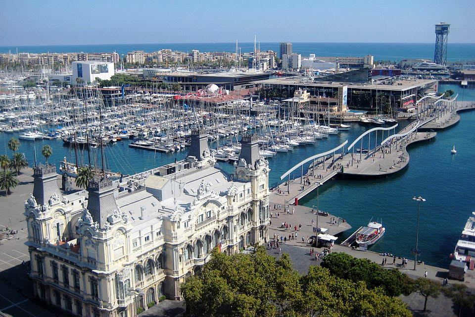
The city port is the Port Vell, which corresponds to the oldest area of the Port of Barcelona, in the District of Ciutat Vella. Historically it was an area dedicated to trade and fishing, but with a view to the 1992 Olympic Games, a transformation began to turn it into a civic space. Among the most outstanding actions in this regard are the opening of promenades such as the Rambla de Mar or the Moll de la Fusta, the transformation of the Palau de Mar into a museum, the construction of the World Trade Center or the opening of the Moll d ‘ Spain with leisure spaces such as the Maremagnum, the IMAX cinema or the Aquarium. In the 2000s, Port Vell was expanded with a new mouth reclaimed from the sea. In this space still changing and buildings are located as the Hotel W.
Port Vell also functions as a marina, with the Real Club Náutico de Barcelona, the Real Club Marítimo de Barcelona and the Marina Port Vell for luxury yachts. Professional fishing, very limited, is maintained in the Moll dels Pescadors, where the Barcelona Fishermen’s Association and the fish market are located.
At present, in Port Vell, fishing and industrial activity coexists with business and various recreational and recreational uses: nautical, sports, hotels, restaurants, shopping centers and museums.
Cruise port
The port of Barcelona has nine passenger terminals distributed between Moll Adossat, Moll de Barcelona, Moll d’Espanya and Moll de Sant Bertrà, of which six correspond to international cruise terminals. In 2017, Terminal E is expected to be operational, making it the seventh international cruise terminal and the port’s tenth passenger terminal.
Commercial port
The Port of Barcelona is a leader in the transport of automobiles in the Mediterranean. In 2016 it reached an all-time high of 916,179 vehicles, thanks in large part to the proximity of the Nissan and SEAT factories. La Dársena Sur has two terminals specialized in this type of cargo.
In 2013, the Port of Barcelona had a total traffic of 42 434 176 tons, 1 720 383 container units – TEUs – and 705 374 cars were managed.
Container terminals
The Port of Barcelona has 4 container terminals covering an area of 210.48 ha and a berthing line of 4,501m (4.5km).
Power port
Pier Energy (old dock of flammable) is intended primarily for reception, storage and distribution of energy resources and chemicals. It has 15 liquid bulk berths for petroleum and chemical products. These will include the largest oil terminal Western Mediterranean, opened in 2012.
Industries such as LUKoil -Meroil, Enagás, Tepsa or Gas Natural Fenosa are installed on this dock, which operates a combined cycle plant with a power of 850 MW. In 2008, the Muelle de la Energía was expanded by 18 Ha reclaimed from the sea. That year the new control tower went into service port, located at Pier Energy, a building design by Josep Maria Botey.
Logistics port (ZAL Port)
The Port of Barcelona Logistics Activities Zone —which operates under the trade name ZAL Port— was established in 1992, being the first ZAL created in Spain. In its first stage, it occupied the southern end of the port, on what was then the left bank of the Llobregat river. In 2006, it spread across the other shore, already in the municipality of El Prat, on land gained by the port after diverting the river mouth 2 kilometers further south. Due to the high occupancy of these spaces, in 2016 the ZAL carried out a new expansion, leasing two plots of the old SEAT factory in the Zona Franca polygon.
In total, the ZAL Port has an area of 212 hectares, among the original 69 hectares (area called ZAL Port BCN), the 143 hectares in El Prat de Llobregat (ZAL Port Prat) and the 27 hectares in the Free Zone (ZAL Port Ciutat). In this space is built 635,000 square meters of logistics warehouses, where 130 companies operate, among which are Decathlon, Carrefour, Damm, Indukern, DB Schenker, Seur, DHL and CMA-CGM.
CILSA (Centro Intermodal de Logística, SA) is the company that manages the ZAL Port logistics platform. It is a public capital company, owned by the Barcelona Port Authority (63%), Merlin Properties (32%) and the Public Land Business Entity, SEPES (5%).