Peyroules, Alpes-Maritimes, Provence-Alpes-Côte d’Azur, France

Peyroules is a French commune, located in the department of Alpes-de-Haute-Provence in the Provence-Alpes-Côte d’Azur region. Located at the gates of the Gorges du Verdon, at the crossroads of the thematic routes of Napoleon and Lavender. La Bâtie is located mainly on a promontory. The town is established around the source of two rivers: that of Artuby, a tributary of the Verdon which flows to the south and the Alpes-Maritimes, and that of Jabron, also a tributary of Verdon.
History
The site of the Mousteiret cave was visited at several distinct times during the Neolithic period. Also in Mousteiret, a prehistoric enclosure was found. The locality appears for the first time in charters in 1045 (Peirolas). The village is then located on a small hill, close to the current site. The Castellane are the lords of the 18th century to the xviii th century, then Valbelle succeed them until the French Revolution. The parish came under the bishop of Senez, while the priory of Saint-Jean-de-la-Foux came under the abbey of Lérins. The community came under the supervision of Castellane.
In the Middle Ages, the inhabitants of Mousteiret and La Bâtie (La Bastida Jabroni , la Bastide du Jabron in 1251) formed two autonomous communities. The parish Moustier Aups fell within the abbey of Lérins who collected the revenue (from the 18th century). In 1441, this priory was united with that of Gratemoine (in Séranon); then it seems to disappear as a priory, and it is his church used to xviii th century disappears. The communities gradually meet: Le Mousteiret was annexed by that of Peyroules in 1278; La Batie is attached to the xv th century, strongly affected by the crisis of the xiv th century (Black Death and the Hundred Years War).
At the beginning of xix th century, the Sainte-Anne River in the hamlet of becoming the parish church, which embodies the déperchement habitat. The Revolution and the Empire brought many improvements, including a land tax equal for all, and proportional to the value of each person’s property. In order to put it in place on precise bases, the lifting of a cadastre is decided. The finance law of September 15, 1807 specifies its modalities, but its implementation takes a long time to implement, the land registry officials treating the municipalities by successive geographic groups. It was not until 1834 that the so-called Napoleonic cadastre of Peyroules was completed.
The coup d’état of December 2, 1851 committed by Louis-Napoléon Bonaparte against the Second Republic provoked an armed uprising in the Basses-Alpes, in defense of the Constitution. After the failure of the insurrection, a severe repression pursues those who rose up to defend the Republic: Peyroules, with two inhabitants brought before the mixed commission, is relatively unaffected. Like many municipalities in the department, that of Peyroules had schools long before the Jules Ferry laws: in 1863, it had three, located in the village, the town of La Bâtie and La Foux, which provided primary education. to boys. No instruction is given to girls: if the Falloux law (1851), which requires the opening of a girls’ school in municipalities with more than 800 inhabitants, does not concern Peyroules, the first Duruy law (1867), which lowers this threshold to 500 inhabitants, is not applied. It is only with the Ferry laws that the girls of Peyroules are regularly educated.
Municipality of Peyroules
The commune of Peyroules is made up of four formerly distinct territories, each of which corresponds to one of the sections of its cadastral plan. To the west, section A covers the former territory of La Bâtie, today a mere gap, formerly a castle town known from the 13th century under the name of “Bastida Jabroni” or la Bastide-sur-Jabron. Annexed from 1278 to Peyroules, this small castral village located along the main road from Castellane to Grasse may have succeeded an older settlement, the only vestige of which seems to be the toponym Villard, which today designates the wooded massif located at the east of La Bâtie. The ridge of this massif, duly prospected, does not apparently contain any vestige of construction, but soil erosion, very important in this area, may be responsible for the void observed.
In the center, section B corresponds to the original territory of Peyroules, of which the castral village, perched at an altitude of 1200 m on the edge of a once intensely cultivated terrace, remained inhabited until the 19th century and left recognizable remains.. The habitat moved, probably from the 16th century, towards the bottom of the valley where it fixed a string of gaps, including that of the River, which today serves as the capital. To the east, the upper Artuby valley was at least one independent stronghold called La Foux until the 14th century. The remains of the castle town have been found on the Peyssivier ridge, above the current hamlet, set in the valley probably in the 16th century.
To the south, in the same valley of Artuby, the gap of Mousteiret perpetuates the memory of another castral village whose site was undoubtedly perched on the ridge north of the hamlet. The latter is fixed around the church, a former priory dependent on the Abbey of Lérins, not far from the road from Castellane to Grasse. Deserted towards the end of the 14th century, the territory was annexed to Peyroules, but constituted an autonomous stronghold until the end of the Ancien Régime. In 1278, Peyroules contained a manor house and 25 fires, the Bâtie 10 fires, the Mousteiret 12. In 1315, the first two villages totaled 52 fires, the Mousteiret 10. In 1471, there were only 12 fires concentrated in Peyroules. The population growth is then rapid (46 houses in 1504, 85 in 1698) and peaks in 1831 with 620 inhabitants. The 1836 cadastre records 331 buildings, including 131 houses and 164 agricultural warehouses, almost all of them built up in the gaps, leaving only about fifteen farms and sheepfolds isolated in the countryside. Since that date, the population has declined sharply.
Reduced to 82 inhabitants in 1975, it increased again and reached 136 inhabitants in 1999. The local economy was for a long time limited to a food crop based on cereals, some fruits and fodder allowing the maintenance of a herd. varied (cattle, horses, pigs, sheep and goats), but few in number. The agricultural abandonment that manifested itself from the middle of the 19th century transformed the cultivable land into pasture for the surviving farms specializing in sheep breeding. Today there are only a few meadows that have been exploited. The site of the Mousteiret cave was visited at several distinct times during the Neolithic period. Also in Mousteiret, a prehistoric enclosure was found.
The locality appears for the first time in charters in 1045 (Peirolas). The village is then located on a hill, close to the current site. The Castellane are the lords of the 18th century XVIII th century and the Valbelle succeed them until the French Revolution. In the Middle Ages, the inhabitants of Mousteiret and La Bâtie (La Bastida Jabroni, la Bastide du Jabron in 1251) formed two autonomous communities. Le Mousteiret was annexed by that of Peyroules in 1278; The builded is attached to the XV th century, strongly affected by the crisis of the XIV th century (Black Plague and Hundred Years War).
The village appears for the first time in the charters to 1045 as Peirolas and of Petrolis (1300) and Perrolas the XVI th century, which designates all stones.
Séguret
In 1836, there was a Séguret gap, made up of 2 groups of buildings (in all 2 houses, 3 agricultural warehouses and a collective oven), none of which no longer exists today. The current gap was probably built before the end of the 19th century alongside and with the debris of the old one. Concentrated in the hands of a single owner, the buildings (or what remains of them) serve as seasonal accommodation for the shepherd who still grazes the south-eastern slope of Teillon. The rural district of Séguret occupies the top of the southern slope of the Barre des Portes, the eastern extension of the Teillon. It is a well-exposed hillside, sheltered to the west by a fold in the mountain and covered with terraces supported by dry stone walls which attest to the agricultural function long assumed by this high sector (1250 m above sea level). average).
Located in the center of the hill, the gap is made up of a single linear block of 6 buildings and a small isolated building on the other side of the main street. All the buildings have the same constructive characteristics: blocking walls of rough rubble with corner chains in dressed stone and discontinuous plaster with visible stones, door frames in dressed stone, windows in rubble under wooden lintel with mortar cladding, one-sided or long-sided roof (2) covered with hollow tiles (replaced in one case by fiber cement), floors with exposed beams carrying rows of thick planks.
The isolated building to the south is a small agricultural warehouse of 16 m², of which the 2 basement floors each have level access, the first to the west, the second to the street to the north. Across the street, all the buildings on the block are roughly the same height. At the western end, the 1st building, very ruined, with an area of approximately 56 m², contained a stable, the ceiling of which was supported by a central pillar, surmounted by a living room to the south (fireplace leaning against the party wall east) and a hayloft to the north. The neighboring house, about 37 m², has 3 floors. The stable-shed on the first floor of the basement opens to the south onto the street through a carriage door with a monoxyl lintel and freestone piers. A straight exterior staircase with monolithic steps leaning against the South elevation leads to the door of the house, on the 2nd floor of the basement, lit by a window on the same side and two windows to the north. Above, the attic has no independent access.
The third building is a semi-collapsed 35 m² agricultural warehouse. The first floor of the base, opened onto the street by a carriage door, was surmounted by two stories of hayloft, the second accessible by a bay window to the north. Another agricultural warehouse adjoins the previous one to the east, of larger dimensions (53 m²), which made it necessary to support the ceiling of the lower storey with a row of posts. The middle floor, used to store hay, was accessible by a door now walled up to the east, at the top of the exterior staircase leading to the neighboring house. This one has its southern elevation set back from the previous ones by about 4 m, partly collapsed despite the support of two buttresses and summarily raised. Its degradation makes the eastern half unreadable, which may have belonged to another house or an agricultural warehouse.
The western half corresponds to a small house formed by a 1st floor basement open to the south by a pedestrian door in segmental arch in freestone, a 2nd floor basement served by a straight outside staircase leaning against the east wall of the previous warehouse agricultural and attic accessible by a door to the north.
The last building, at the east end, a large rectangular volume of 74 m² covered with a long, collapsed roof, housed a sheepfold, opened to the west by a carriage door, and a hayloft opening onto the south gable. a 2nd floor basement served by a straight outside staircase leaning against the east wall of the previous agricultural warehouse and an attic accessible by a door to the north. The last building, at the east end, a large rectangular volume of 74 m² covered with a long, collapsed roof, housed a sheepfold, opened to the west by a carriage door, and a hayloft opening onto the south gable. a 2nd floor basement served by a straight outside staircase leaning against the east wall of the previous agricultural warehouse and an attic accessible by a door to the north. The last building, at the east end, a large rectangular volume of 74 m² covered with a long, collapsed roof, housed a sheepfold, opened to the west by a carriage door, and a hayloft opening onto the south gable.
Hamlets
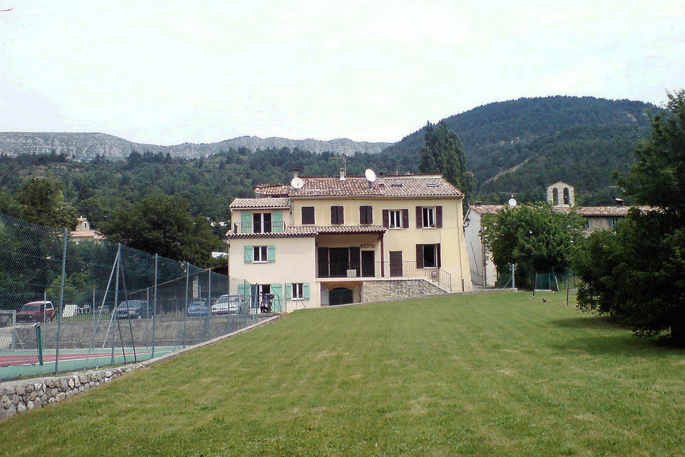
The old village, or Vieux-Peyroules, is a castle town, established near a fortified castle (in ruins). The so-called Ville de Ville church, under the name of Saint-Pons (Romanesque, built in the second half of the eleventh century according to Raymond Collier, founded in the seventh century and remodeled in the fourteenth century according to the DRAC) has been restored there: only lit with narrow bays like loopholes, the nave opens into a semi-circular apse. The main portal, on the southern facade, is semicircular, with keystones. It is listed as a historical monument. In the village of Peyroules, or de la Rivière, the town hall is located in the old manor house, dating from the eighteenth century (repaired in 1844).
The Hameau de la Foux
La Foux is also a castle town, whose castle was built at a place called Croix de Peyssivier in the second half of the 13th century. Saint-Jean-Baptiste Church in La Foux, a sequence of the film Jeux interdits was filmed there; Fortified farm in La Foux also, with dovecote.
Church of Saint-Jean-Baptiste and its bell from 1560, at La Foux, a sequence of the film Jeux interdits was filmed there;
The Notre-Dame and Saint-Jean-Baptiste oratory;
Fortified farm in La Foux also, with dovecote.
The Hameau de la Bâtie
La Bâtie is also a former castle town, formerly called the Bastide-du-Jabron, founded in the 13th century. The chapel of La Bâtie dates from 1651. Its bell tower is above the western facade.
The chapel of La Bâtie, under the invocation of the Transfiguration but commonly called Saint-Sauveur, former branch of the parish of Peyroules, dates from 1651. Its bell tower is above the western facade.
Mousteiret
In Mousteiret, there is another castral village, with a troglodyte shelter, very difficult to access. Chapelle Notre-Dame, currently closed.
Historical heritage
The old village, or Vieux-Peyroules, is a castle town, established near a fortified castle (in ruins).
The church Peyroules called City, under the patronage of Saint-Pons (Romanesque, built in the second half of the 16th century by Raymond Collier, founded in the vii th century and rebuilt in the xiv th century according to DRAC) y was restored (the last work dating back to 2013): only illuminated narrow bays as slits, the nave opens into an apse semicircular. The main portal, on the southern facade, is semicircular, withkeystones. It is listed as a historical monument.
In the village of Peyroules or the River, the town hall is located in the former manor house dates from the xviii th century (repaired in 1844). The church parish Sainte-Anne houses a banner in procession representing the Adoration of the Blessed Sacrament (125 cm of 73), where the Blessed Sacrament is adored by angels. Dating back to the xix th century, it is protected as an object registered since 1987.
War memorial and commemorative plaques.
Cultural heritages
The churches
The churches of the town are remarkable buildings. All the churches in the town have been restored. The decorations and period paintings have also been restored.
The Fountains and the Washhouses
The fountains and washhouses in the hamlets are part of the town’s cultural heritage. Steeped in history, these buildings were once important places in our villages.
The Oratories
The oratories, religious symbols, represent buildings steeped in history. Each year, during the Saint-Pierre procession, the oratories are visited. Each hamlet has a religious “Saint”, who is generally represented in the oratory of the village.
The Communal Ovens
Communal ovens are important places of life in our small rural villages. A meeting place or gathering place for the inhabitants of the hamlets, they were once active and allowed the inhabitants to be able to cook their food. All the ovens in the Municipality are restored and in working order.
Typical streets
Our hamlets are full of typical streets and alleys. Maintained and decorated with flowers by the inhabitants, they bring a cachet to the Hamlets of the town.
Saint-Pons Chapel
The old village, or Vieux-Peyroules, is a castle town, established near a ruined fortified castle. The Saint-Pons chapel is a religious building, classified and registered by decree of September 11, 2006 and currently undergoing restoration. The work is directed by the services of the DRAC.
Agriculture
The commune of Peyroules is a magnificent preserved area, and this thanks in part to its farmers, over the generations they have maintained and shaped the landscapes. From the Teillon mountain pastures to the vegetable fields on the banks of our rivers, early in the morning or late at night our peasants try to subsist in the most ancestral way possible, thanks to cultivation or breeding.
The harshness of the climate, which is very dry in summer and very harsh in winter, does not allow intensive large-scale cultivation; most of the land is intended for grazing sheep and a few cattle. The mechanized surfaces are essentially natural meadows, at the time of ecological and environmental concerns it is a major asset for our extensive agriculture and respectful of its land. From the Peyroules plateau to Mousteiret and in the depths of our valleys, despite the drought and the frost, farmers succeed in cultivating more noble fodder species and even good vegetables.
Mountain potatoes have a very good reputation on the coast, organic or conventionally, vegetable fields bloom at the beginning of summer for our greatest pleasure, the hamlet of La Foux has a major asset since it is endowed with the collective irrigation network, elsewhere the lack of water turns out to be a big drawback for these productions. Most of the land is used for pasture, the Teillon mountain pasture which hosts hundreds of sheep in summer is the best example, it is thanks to the sheep, the cows and the horses that there are still some beautiful pastures. in our town, the animal’s tooth is the best brush cutter there is.