The region of Osona, located at the northeastern end of the central Catalan depression, is surrounded by the pre-Pyrenees (north) the transversal mountain range to the northeast, the pre – coastal mountain range to the southeast, and in the northeast of the Central Counties.
The Osona County Council was formally constituted in 1988, the year in which the Generalitat de Catalunya set up county councils throughout the territory. From that moment until today, the institution has accumulated a long and recognized history accompanying and providing services to the 50 municipalities of Osona and all its citizens.
The capital of the region is Vic, located in the center of the region and also in the center of the plain of Vic, which occupies the central space of the region. It borders the following counties: to the north with Ripollès, Garrotxa and Berguedà, to the west with Moianès and Bages, to the east with La Selva and to the south with Vallès Oriental. The boundaries of the region comprise the bulk of the subregion’s natural Lluçanès (sotsvegueria historical), the Voltreganès and Guilleries. They include most of the historic County of Osona.
This natural depression in the center of the region was carved by river Ter and its tributaries and makes up a big part of Osona’s land. It is completely surrounded by mountains: The Sub-Pyrenees, with Bellmunt mountain towering in the north, the Lluçanès (Pre-Pyrenees) to the north-west and Moianès high plateau in the West, the Montseny in the southeast and the Guilleries, located at the apex of the Catalan Transversal Range and the Pre-Coastal Range, in the east.
Long famous for its local sausages (especially fuet) and other pork derivatives, in recent years the area has become somewhat infamous for the pollution of its many waterways due to the factory farming of pigs and Dairy cattle. There are more pigs than people living in Osona.
Tourism
Walk among stunning scenery, enjoy the best cuisine and immerse yourself in the culture. Discover the essentials during your visit to the Osona region. We like our region and we want to accompany you to discover it. You will find your place there whether you are a thirsty walker of new landscapes to discover, a time traveler who wants to reveal the secrets of history and art, a lover of good food, a seeker of new experiences and activities or if you feel the call for peace and tranquility of our peoples and landscapes to get away from the hustle and bustle of everyday life.
The Osona region, with its capital in Vic, is strategically located halfway between the Pyrenees and the Costa Brava, and an hour’s drive from Barcelona and Girona. With a great diversity of tourist offer in an environment characteristic of the inland territories, it has all kinds of accommodation ranging from campsites to rural tourism houses, hotels, hostels and apartments.
Cultural tourism in Osona encompasses a rich diversity of historical resources that date back to prehistory, with important vestiges of the Romanesque, a style deeply rooted in the region. Literary and industrial tourism also has its specific weight within the territory.
The landscape and territory of Osona are also ideal for activities in nature, and the wide range of fairs and markets, festivals and popular traditions contribute, along with its cuisine, to expand the possibilities of turning a visit to the region into a great experience.
Destinations
The Osona region and its capital, Vic, are strategically located halfway between the Pyrenees and the Costa Brava, and an hour’s drive from Barcelona and Girona. Thanks to the landscape of inland Catalonia and this unique location, the region offers a wide range of attractive proposals to fill your free time.
Cities
Our cities are the ideal counterpoint to the rural environment of Osona. The capital, Vic, with its monumental historic center; but also Manlleu and Torelló, you will be surprised by the commercial dynamism of its streets and squares, by its fairs and markets, by the cultural offer and the architectural heritage.
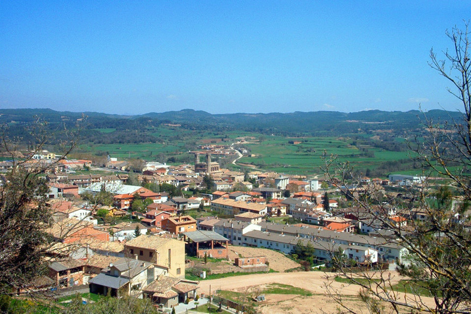
Vic
Halfway between the sea and the Pyrenees and only seventy kilometers from Barcelona, the city of Vic is the demographic, administrative and service center of a geographical area that exceeds the limits of the Osona region. Its long history, present in the streets and squares of the historic center, coexists in harmony with the new urban growth, which shows the dynamism of a cosmopolitan city, expressed through the echo of its fairs and markets, the consolidation of the University of Vic or the growth of industrial estates. The historic center of the city has a signposted route that allows you to pay attention to some thirty buildings of historical, architectural or artistic interest, including the Roman Temple, from the second century; the 14th century walls; the cathedral, where Romanesque, Gothic, Baroque and Neoclassical converge; the mythical Plaza del Mercadal and the town hall.
The rich cultural heritage of the city of Vic is manifested in its museums, especially the Episcopal Museum of Vic, which has one of the best collections of Romanesque and Gothic art in Europe, and the Museum of the Leather Art, dedicated to the decorative and applied arts of the skin. In addition, Vic has become in recent years an essential point of visit to learn about the work of Josep M. Sert (1874 – 1945). This artist developed a pictorial work for which he was considered the best muralist painter of the thirties.
Manlleu
Manlleu privileged location on the river Ter. The river has become the architect of this territory located between two of the most characteristic meanders of the Plain. The pebbles, dragged by the river, are present in many of the urban constructions (and in the same bell tower, a watchtower that rises majestically from the hill that forms the Dalt Vila). It was also the water of the Ter, domesticated in an industrial canal, which made possible the first modern industrialization of the region in the middle of the 19th century.
At present, we can see a group of urban and river factories along 4 km of river front that has the term: among them, the Cau Faluga, the former residence of the Rusiñol family. And within the town center, the monumental Noucentista square of Fra Bernadí and Can Puget, along with educational centers, theaters, associations, cooperatives, and a whole series of houses for workers and residential houses of the manufacturers, which have become a magnificent example of living history. The visit to the Ter Museum allows us to know the historical aspects of the industrialization process in the middle Ter. Machines and models help to understand the process of transforming cotton into yarn, and to understand the change they brought to society. The guided tour allows you to see the spectacular commissioning of one of the oldest turbines in the Ter – the Fontaine turbine of 1860.
Torelló
The river Ges occupies the bottom of the valley and in Torelló it joins the river Ter. The combination of an important natural, cultural and historical architectural heritage makes Torelló an important nucleus. It is a confluence of culture, landscape, tradition and innovation. The area where the municipality of Torelló is located today was already inhabited in the Neolithic period, as shown by the tombs of Les Serrasses.
The center of Torelló has a double slope: on the one hand the Plaça Vella as a remarkable old quarter, with its porches and old houses, and on the other, the Plaça Nova and the Church of Sant Feliu built in 1672 and with modern paintings by Joan Rifà. There is the Sanctuary of Rocaprevera, from which you can see a magnificent view of the Plain of Vic, the Collsacabra and the Pyrenees. It is necessary to emphasize all the patrimony associated to the establishments of the time of the industrialization of the Ter. Numerous activities throughout the year make it an enterprising town: the Inland Carnival, the Trasto Market, the International Mountain and Adventure Film Festival, the Festus…
Municipalities
Alpens
Alpens is located in the northeast of Osona, in Lluçanès, on the border of Ripollès with the city of Les Llosses and on the border of Berguedà with the city of Borredà. It has an area of 13.82 square km and has an altitude of 855, is mountainous and there are heads of the streams Lluçanesa, Gavarresa and Sora. The continental climate gives the forests of red pines, oaks, holm oaks, beeches… with boxwood, juniper and hawthorn. We can also find a variety of medicinal and aromatic plants (such as thyme, lavender,…) and a lot of mushrooms. The municipality stands out mainly for its forging elements. Walking through the alleys of its old town, you can see some details made of wrought iron on each door or balcony -such as door knobs, lanterns, railings or grilles-, mostly by the blacksmith Joan Prat (1898-1985).
In addition to these elements, we must also add the sculptures that shine in different parts of the town, turning it into an open-air museum. These are: At the entrance to the Plaça Major sculpture of the Manelic (Joan Prat). In the entrance park, sculpture of blood donors (Enric Pla). In front of the Old Factory the Tree of Vulcano (collective work directed by Miquel Xirau in the IX Meeting of Blacksmiths). On the branch, an allegorical sculpture by the Colla dels Diables d’Alpens (collective work directed by Miquel Xirau at the X International Meeting of Blacksmiths). On the Paseo de la Carretera de Berga, sculpture La Dansa Alpensina (collective work directed by Miquel Xirau at the XI International Meeting of Blacksmiths). Other notable places of interest in Alpens are the Parish Church of Santa Maria, a Baroque-Neoclassical building that has changed greatly over the years, and the sanctuary of Sant Pere de Serrallonga, a small pre-Romanesque temple from the 9th century.
Balenyà
The municipality extends along the headwaters of the Congost river (a tributary of the Besòs), and climbs towards the Ponent or Puigsagordi mountain range and to the northeast until the restaurant touches the 4 roads. Els Hostalets, a name by which it is popularly known, was created in a strategic place, at the top of the old Pujolric or Sant Antoni climb. There we find the fork of the Camino de la Cerdanya and the Camino Real. Both were heavily trafficked by roadmen and haulers. In the middle of the 16th century, a hostel was built there, which was very crowded due to its location, which gave rise to the current town, next to the church of Sant Antoni and a hospital. The first news of the town dates from 1551. In time, the blacksmith, the carpenter, etc. settled there. But it was in 1920 when Hostalets de Balenyà went from 854 inhabitants to 1,217 in 1940. Today, the town has a well-established and expanding trade. The estate, with various industries, such as carpentry, meat and sausages, employs many inhabitants of the municipality and the region.
Calldetenes
The municipality of Calldetenes, 5’80 km2, is located two kilometers from Vic and is the third smallest in the region of Osona. Calldetenes is bordered on the north by Folgueroles, on the west by Vic, on the southwest by Santa Eugènia de Berga, and on the southeast and east by Sant Julià de Vilatorta. The term has an average altitude of 489 meters. The terrain is flat and generally low, with the exception of the typical witness hills of the plain. The hills are made up of gray-blue marls, popularly known as “Vic marl” or “dead stone” due to their low compactness – they fall apart easily. The marls, shaped by rainwater, give rise to a flattened relief. St. Mark’s Hill is a good example. Its height, 580 meters, makes it one of the viewpoints of the Plana de Vic.
Centelles
The village was born around the shrine of the church of Santa Coloma de Pujolric, which later became known as Santa Coloma de Vinyoles. Already in the twentieth century, despite continuing to be an imminently agricultural town, it has a considerable commercial and industrial development, especially in the food and textile sectors, and also summering due to the impetus of the passage of the railway through the village. Recently, the inauguration of various facilities and the economic, industrial and cultural vitality make Centelles a town ready to face the challenges of the 21st century.
El Brull
Much of the area belongs to the Montseny Natural Park, Biosphere Reserve, of which the Brull is one of the major gateways through the road BV-5301, from Seva to Palautordera that crosses the Montseny via Collformic. Until now formed by three population centers: El Brull, Sant Jaume de Viladrover and Sant Cristòfol de la Castanya. And now we can add another, the urbanization of L’Estanyol, which emerged in the last decade, physically located between the nuclei of El Brull and Sant Jaume de Viladrover, on the back of the golf course.
Espinelves
Espinelves is a town in the region of Osona, but belonging to the demarcation of Girona. It is popular for its natural surroundings, its Romanesque church and its peculiar specialty in Christmas trees. Espinelves is located in the largest forest in Catalonia, in the Montseny-Guilleries area, in the mountains and near the sea. It is an area with fresh groves, clean water and fresh air.
Folgueroles
Folgueroles is a small municipality located between the Plana de Vic and the beginning of the Guilleries, which join in the eastern sector of the term that allow you to enjoy nature, literature, the heritage built in stone and gastronomy. The soft western relief, which houses farmhouses and some small hills (such as Les Mentides, Sant Jordi de Puigseslloses), becomes abrupt in the east, with ravines and depressions full of vegetation through which streams such as Folgueroles flow (tributary of the Gurri) or the Lledoner. Folgueroles saw the birth of Jacint Verdaguer on May 17, 1845, and today it still preserves different spaces of the poet’s life, such as some of the settings of his childhood and youth games. Since then, the town has been endowing itself with seeds of artistic elements erected in their memory.
Gurb
The municipality of Gurb covers an area of 51.23 km2, is located in the heart of the Osona region forming part of its central core, the Plana de Vic. The surface of the municipality is distributed in four parishes: in the western sector with the most mountainous relief there are the parishes of Sant Julià Sassorba (on the south side), and Sant Cristòfol de Vespella (on the north side); on the east side, in the middle of the plain, that of Sant Esteve de Granollers, and between the plain and the mountain, there is the parish of Sant Andreu de Gurb, which constitutes the central nucleus of the municipality.
Les Masies de Roda
The population is basically located in farmhouses (many of which date back to the Middle Ages: important farmhouses in the history of the region), and in four towns: the Cases Noves, the Esquerda, Fontanelles and the Vicenç. In 1805 the Masies de Roda and Roda de Ter were separated from the municipality of Sant Pere de Roda, although the history dates back to ancient civilizations, as the archaeological site of L’Esquerda, located on a meander of the river Ter, was a settlement occupied by the Iberians and until the Middle Ages.
Les Masies de Voltregà
Les Masies de Voltregà has a total area of 22.2 km2 and its territory is divided between the nuclei that make it up: Vinyoles, La Gleva and others that are becoming more important every day: El Despujol, El Poble- Sec, Burrissola or Sant Miquel d’Ordeig. The numerous farmhouses that are scattered throughout its territory are also part of the municipality. Among the most emblematic places in the town are: the sanctuary of La Gleva, the ruins of the Castle of Voltregà and the Romanesque church of Vinyoles.
Les Squirrel
The municipality of L’Esquirol is the natural path or gateway to the Collsacabra. It is a very large municipality made up of four towns: Sant Martí Sescorts, in the lower part of the town, a very small town around the church, most of the population lives in farmhouses; l’Esquirol, its origin is located in an old hostel that was located right next to the Camino Real from Vic to Olot; Cantonigròs, is the second most populated town in the municipality, its origin is also, an old hostel on the Camino Real from Vic to Olot, created by the Gascon Antoni Prat, also called Toni Gros; Sant Julià de Cabrera, is made up of isolated houses, with a tiny nucleus where there is a Romanesque church, the rectory and a manor house, from here there are many paths that go up to the hermitage of Cabrera (1300 m.) and worth a visit.
Lluçanès
With its landscape, roads, heritage and villages it is an ideal territory for all kinds of routes on foot or by bike. Apart from the large urban centers, Lluçanès today maintains the discreet and hidden charm of the rural world. Landscape, art and first-class gastronomy come together on this plateau. The heritage of livestock activity has given modern times architectural and heritage elements of great historical and cultural value, as well as different paths for transhumance.
The Lluçanès is dotted with farmhouses with a lot of history, such as the Vilar, mills, beatings and tiles that turned the houses into self-sufficient worlds, living villages with the air of centuries ago, such as Alpens, Sant Feliu Sasserra or Sant Boi, but also of some abandoned, like Salselles. The heritage of Lluçanès includes altarpieces, ceramics, enamels, wrought iron, lintels, boulders and many intangibles: legends, songs and folklore.
In addition, the location of Lluçanès makes it a magnificent viewpoint on all sides giving us priceless postcards. A list of thirteen high points and viewpoints – one per municipality – make up the Miradors del Lluçanès, accessible by vehicle except one. Apart from these, there are many other places where you can enjoy extraordinary views of the Lluçanès, as well as glimpse such emblematic massifs as Montserrat, Montseny, Pedraforca, or the Pyrenees Orientales.
Malla
Malla is a rural village located in the south of the region with a population that mostly lives from agriculture and livestock. In this municipality there are about sixty farmhouses spread over 11 km2. Fundamental pieces in the landscape of Malla are the Church of Sant Vicenç, which together with the rectory, the museum of Malla and the cemetery form a very important historical ensemble.
Montesquiu
Montesquiu is a village located in the north of the region to which it belongs since 1990, before it belonged to the region of Ripollès. Montesquiu has an area of 4.8 km2 of very rugged terrain, although there are no high elevations, the lowest point is the river bed, with 560 meters above sea level and the highest is the top of the mountain located to the northeast of the farmhouse of La Solana, which belongs to the Serrat de la Rovira, and which has an altitude of 885 meters. The relief of the area marks the transition between the plain of Vic and the Pyrenees.
Muntanyola
The historic municipality of Muntanyola is made up of entities with a very different history and evolution until the definitive creation of modern municipalities, which dates back to 1840, Munter, pronounced in the region “Munta”, appears in 929 with the name of Villa of Montari, and in other documents Montabri. In this small town, originating in a rural town, a church dedicated to Sant Esteve was erected before 929, and on a small hill nearby, a castle was built, which became the jurisdictional center of the town.
Olost
Olost is to the south of the Lluçanès plateau, in a small valley furrowed by the Olost stream at an altitude of 580 meters. The La Gavarresa stream and the Lluçanès stream, one of its tributaries, run parallel from north to south through the town on the western side. Santa Creu is a town attached to Olost, located 606 meters, on the other side of La Gavarresa. The terrain is quite rugged, with its own medium mountain vegetation. The forests are populated mainly by oaks, pines and Scots pine. There are also some areas with holm oaks.
Orís
The municipality of Orís, 27.33 km2, occupies the northern sector of the Plana de Vic. The Ter drains the lands of the municipality by the sector of the east and partly forms natural limit with those of Sant Vicenç de Torelló and Torelló. The municipality of Orís is comprised of five scattered nuclei, where the 240 inhabitants that the town currently has live, and who are: The Parish of Sant Genís, Can Branques, El Pelut, Saderra and La Mambla. There is a fact that unites all the nuclei of the municipality of Orís, and it is the livestock agricultural activity that is developed throughout the municipality, being the means of life of the majority of the people of Orís, we could say peasant village with fertile land very suitable for the cultivation of the buffet potato.
Oristà
Oristà is located in the southern part of Lluçanès, has an area of 68.88 km2. The average altitude is about 700 meters. Its term is crossed from north to south by the Gavarresa stream. Territory much appreciated by nature lovers. From the highest points of the municipality you can see on clear days, Cadi, Montserrat, Montseny, Pedraforca, Rasos de Peguera, Collada de Tosses, etc.… as more distant references. The municipality is rich in pre-Romanesque and Romanesque art. One of the most representative architectural jewels of the region is the pre-Romanesque crypt.
Perafita
The first documentary mention is from the year 909. In 1396 the Lluçanès sub-district was created. One of the capitals was Perafita (the other was Sant Feliu Sasserra). The condition of administrative center caused for the population a remarkable growth with the establishment of weavers and other artisan trades as well as the arrival of French immigrants. In 1714 it was set on fire by the Philippian troops during the War of the Spanish Succession, in revenge for the participation of Jaume Puig, from Perafita, in favor of the Austrian pretender.
Prats de Lluçanès
Prats de Lluçanès, with only 13.29 km2 of surface, is the smallest municipality in the whole area of Lluçanès; it extends in the middle of the depressions of the streams of Merlès and Lluçanès. The plateau that forms the municipality with respect to the neighboring lands, with an average of 700 meters of altitude, makes you enjoy splendid panoramic views of the whole Lluçanesa region to the mountains of Berga, Pyrenees, Montserrat, Montseny … Prats de Lluçanès has become the capital of the Lluçanès region, of which it is the most important and dynamic population.
Roda de Ter
The municipality of Roda de Ter is located in the north of the region next to the river Ter. Its extension is 2.23 km2, since in 1805 its territory was divided when the Masias de Roda split. It has been the presence of the river Ter, which has meant that since prehistoric times, various groups of settlers have occupied this place. We can say that the people owe to the river their temperament, their personality and their wealth. Roda de Ter saw the birth of Miquel Martí i Pol on March 19, 1929, poet, prose writer and translator, he is one of the most popular and widely read contemporary poets; for this reason and for the social, civic and national commitment of his work, he has been considered “the poet of the people”. The Miquel Martí i Pol literary route remembers and pays homage to the poet following his life trajectory through the town.
Rupit and Pruit
If there is one place in Catalonia where the landscape has found the perfect balance between geological grandeur and human scale, this is the Collsacabra, in the center of which is Rupit, a village that seems made to admire it and that it preserves the old calm of its cobbled streets and framed by houses from the 16th and 17th centuries. A few kilometers away, a scattered set of farmhouses, known as Pruit, evokes the times when wealth was tied to the land. Its location has made Rupit i Pruit an ideal place to seek calm through the quiet beauty of a plateau that offers places such as the Sallent waterfall, Sant Joan de Fàbregues and small Romanesque buildings scattered throughout the mountain. Guided tour of the streets of the historic center of Rupit where its history, anecdotes and legends are told. Rupit is a village of medieval origin that still retains the charming appearance of its stone houses of the sixteenth and seventeenth centuries.
Sant Agustí de Lluçanès
The municipality of Sant Agustí de Lluçanès has two small towns, Carrer de l’Alou and the neighborhood of Sant Agustí, along with a scattered neighborhood of farmhouses, make up this small town of 13.38 km2 in the northern sector of the Lluçanès. The characteristic landscape of this plateau combines the pastures with the extensive red pine and oak forests and the extreme use of fodder and cereals in the plain.
Sant Bartomeu del Grau
Sant Bartomeu del Grau, located to the east of Lluçanès, is separated from the Plana de Vic by the steep coast to the east of the village. The considerable altitude of the mountains that surround the village, around 900 meters, allows you to see splendid views of the plain of Vic and the surrounding mountains (Montseny, Guilleries and Collsacabra, Puigsacalm), much of the Pyrenees Eastern (Canigó, Puigmal, Pedraforca, Cadí) and the mountains located to the south (Montserrat).
Sant Boi de Lluçanès
The municipality of Sant Boi de Lluçanès is located in the north of the region with an area of 21.17 km2. It is quite well delimited by mountain ridges forming almost a valley. From north to east along the Munts mountain range (1050m), Puigcornador (977m) and the Sant Salvador mountain range (952m). From west to south through Vilarrasa (867m) to Cornet (857m). To the south by the Sobremunt mountain range (892m). The town is located at the foot of the Munts and on a gentle slope to the bottom of the valley, where the Sorreig stream flows, not very large, as it is located shortly before entering the area.
Sant Hipòlit de Voltregà
The municipality of Sant Hipòlit de Voltregà with 0.97 km 2, is the smallest in the region and one of the smallest in Catalonia. It is located in the middle of the plain and completely surrounded by the municipality of Les Masies de Voltregà. In Sant Hipòlit de Voltregà we find a typical relief of La Plana, despite being close to the eastern mountain ranges of Lluçanès. This small land surrounds the hill where the original church of the primitive nucleus of the town is located, protected by a part of the mountain range of the Cross of Morral.
Sant Julià de Vilatorta
The village of Sant Julià de Vilatorta breathes a privileged natural environment in the middle of the proud greenery of the forests of Les Guilleries. It drinks from the free and generous waters of its springs and is adorned with beautiful buildings of modernist architecture that give it the stately seal of the ancient and sumptuous summer villas. Formerly also known as a pottery village, it faithfully watches over the preservation of its centuries-old traditions and spreads them to the four winds with the songs of joy and festivities of the Caramelles del Roser. Sant Julià de Vilatorta shows its visitors a wide range of options and proposals and is delighted to enjoy their stay with us with a varied and satisfying experience that encourages them to repeat it over and over again.
It also offers comfortable accommodation in any of its hotels, hostels and rural houses, committed to sustainable tourism, responsible for the environment, which value the territory, the landscape, the conservation of the environment and the typical gastronomy. traditional that seeks to enhance the area’s own resources. Their friendly treatment, especially family, and the placid tranquility that exhale their surroundings will contribute pleasantly to the enjoyment of a well-deserved rest or a desired holiday. Restaurateurs are firmly committed to promoting and recovering local zero-kilometer products that rediscover our baggage and gastronomic culture. We have outstanding chefs who energize and promote it with innovation and the creation of new dishes, without renouncing its roots, at the base of our Catalan cuisine very rich in quality and variety and healthy Mediterranean.
Sant Martí d’albars
Sant Martí d’Albars is one of the least extensive and populated municipalities in the region, located at the confluence of the Lluçanès and Gavarresa streams, which make it the western and eastern boundary. Most of its territory is occupied by pastures and bushes. The municipality is structured in three nuclei: Beulaigua, La Blava (where the town hall is located) and Sant Martí. With the exception of Sant Martí, the other two nuclei were born in the 18th century as a result of the activities generated by the passage of transhumant herds that found in this ridge an ideal passage between the two streams to cross the plain to the Pyrenees and Pre-Pyrenees mountains.
Sant Pere de Torelló
Located in the northeast of the region at the confluence of the rivers Ges and Fornés, and walled to the north and east by imposing mountain ranges, Sant Pere enjoys a privileged natural environment. Its municipal area of 57.42 km2 is one of the largest in the region. Due to their special characteristics, the Puigsacalm-Bellmunt-Milany mountain ranges, which are largely within the municipality, form part of the Plan for Areas of Natural Interest (PEIN). It is worth mentioning that Sant Pere is the 5th municipality declared with the most monumental trees in all of Catalonia; 70% of the municipality is made up of forests, groves and pastures.
Sant Quirze de Besora
Sant Quirze de Besora is a municipality located on the banks of the river Ter as it passes through the north of the region. Nestled in the Bisaura, halfway between the plain and the Pyrenees, with the Sierra dels Bufadors and the Sierra de Milany to the northeast, the Sierra de Bellmunt to the southeast and the eastern part of the Lluçanès plateau to the east. west. Its most emblematic tourist attractions are the municipal park on the banks of the Ter and the various springs of the village, along with the pre-Pyrenees landscape that surrounds it.
Santa Eugènia de Berga
Santa Eugènia de Berga is located in the middle of the plain of Vic. The explanation of the name Berga derives from the etymology of Ligurian or Celtic origin which is equivalent to height or elevation of the terrain. By the place where it is within the plain its term is basically flat. With an area of 6.34 km2, extended to 400 ha. segregated from the municipality of Taradell, the differences are given by the 480 m. in the course of the river Gurri and the 580 m. of the Sierra de Sant Marc and the Sierra de Puigsacost, from where you can see an impressive panorama of the entire northern part of the plain of Vic, the Montseny massif (Matagalls), the Guilleries, the Collsacabra and the Pyrenees with the Puigmal as the highest point.
Santa Eulàlia de Riuprimer
Santa Eulàlia de Riuprimer is a small town in the Osona region with a long agricultural and livestock tradition that has managed to maintain to this day. It is a municipality with a high quality of life and is an ideal town for those people who do not know how to adapt to the life and customs of the city and prefer the tranquility of the rural world. The oldest nucleus of houses focuses on the parish church with origins dating back to 899. Later the building was modified and expanded to have its current appearance. The church has a Romanesque roof and a rattle that is preserved in very good condition and is one of the few specimens left in Catalonia.
Santa Maria de Besora
Municipality of Bisaura, facing south, very sunny and quiet, is located in the plain of Teia, at the foot of the hill where there are the remains of the castle of Besora and the Romanesque church of Santa Maria, consecrated in 898. The current municipality was part of the term of the castle of Besora. The town of Santa Maria de Besora belonged to the municipality of Sant Quirze de Besora until 1798, the year of its segregation. Currently, although there is a sawmill, the economic activity of the municipality lies in agriculture and livestock.
Seva
Population that extends from the foot of Montseny to the Congost valley, formed by two sectors separated by the municipality of El Brull. The town was an old shrine surrounded by walls from the twelfth to fifteenth centuries and still has an arrangement centered around the parish church of Santa Maria, Romanesque style and crowded inside, and with old houses adorned with windows from the thirteenth to sixteenth centuries.. The term also has old farmhouses of remarkable architectural value.
Sobremunt
On the mountain range of Sobremunt there is the municipality of the same name, riding on the plain. Numerous streams flow into the mountain range that converge in the Sorreigs stream, a very interesting natural space that flows into the Ter. It is one of the most rural municipalities in Lluçanès, with three basic sectors: the town of Sobremunt, the hamlets of Sorreigs and Santa Llúcia de Sobremunt. The term consists of a small town and isolated farmhouses.
Sora
Sora is a village surrounded by woods and with a large population scattered in farmhouses that has historically been dedicated to agriculture and livestock. The municipality of Sora, in the north of the region, on the border with Ripollès, has an area of 31.5 km2, and borders the municipalities of Alpens, Sant Agustí de Lluçanès, Sant Boi de Lluçanès, Orís, Sant Quirze de Besora, Montesquiu and Les Llosses. Sora has three population centers: Sora, El Serradet (where the La Teuleria industrial estate is located) and Cussons.
Taradell
Taradell is located next to Montseny, the plain of Vic and Les Guilleries. This location makes the municipality cover a territory of interbreeding between the mountains and the plain. Two spaces that go hand in hand in the main town of this town. Taradell is a municipality that facilitates, through a dense network of paths, trails and trails, sports and leisure activities, with special emphasis on walks and excursions to places of remarkable cultural and landscape interest.
Tavertet
Tavertet breathes a feeling of comfortable isolation due to its impressive location on the steep slopes that fall, abruptly, on the Ter and the fact of preserving many of the houses built in the seventeenth and eighteenth centuries, the sober functional elegance which characterizes the architecture of the country. This has earned it being declared a Site of Cultural Interest and, in addition, hosting an association dedicated to interculturality and free spiritual living. At its end, of striking singularity, there are important vestiges of Romanesque art, among which the church of Sant Miquel de Sorerols is a must, one of the most exemplary examples of this architectural style that can be admired in the extensive region of Osona.
Tavèrnoles
The fine Romanesque bell tower of Sant Esteve makes the silhouette of Tavèrnoles unmistakable, located at the end of the plain, where the Guilleries begin to climb. A renowned gastronomy coexists next to ancient stones that speak of noble families and ancient settlements (Sant Feliuet de Savassona), of paths that go up to the legendary place of the Guilleries or lead to the cliff that dominates the valley of Sau from this slope, and of routes to travel on horseback or by bicycle. Tavèrnoles is the entry point of the Sau reservoir at its western end and a good place to start a visit to the monastery of Sant Pere de Casserres, a remarkable Romanesque building that dominates the course of the Ter.
Tona
Tona, with a municipal term of 16.47 km 2 and an average altitude of 598 ms. above sea level, it is part of the Vic plain. Thanks to the discovery of the sulphurous waters discovered at the end of the 19th century, Tona became a summer village with many stately homes and a spa, which have given it a luxurious profile that makes walking a pleasure.
Vidrà
Vidrà is a municipality of just over 34 km2, formed by the town of Vidrà, the Creu de l’Arç and the neighborhood of Ciuret, and different farmhouses. In the north of the Osona region, to which it has belonged since 1989, although, in fact, it is part of the province of Girona. Surrounded by the mountains of the pre-Pyrenees, to the north (Serra de Milany and Santa Magdalena) and by the Serralada Transversal to the southeast (with Cims de Puigsacalm, Puig Curull, Puig Tosell, Puig dels Llops and Puig de les Àguiles). The whole area is included in the PEIN (plan of areas of natural interest) except the enclaves of Vidrà, the neighborhood of Ciuret, and part of Collfred (farmhouse). In terms of architectural heritage, in Vidrà we find several Romanesque hermitages (Santa Margarida de Cabagès, Sant Bartomeu de Covildases, Santa Magdalena de Cambrils…), the remains of the Castle of Milany, a medieval bridge and especially the characteristic farmhouses, some with roots in the history of our country.
Viladrau
Viladrau is part of the Osona region, although it is from the province of Girona. The municipal term has an extension of 51 km 2 and the town is to 821 ms of altitude and has 1,036 inhabitants. It is located in the contact area between Montseny and Guilleries. It is of great beauty for the lush forests and abundance of water, which makes it a traditional place for tourism and summer.
Vilanova de Sau
In 1962, the reservoir was opened and, since then, the appearance of the Vall de Sau has changed. The village of Sant Romà disappeared under the water and only the bell tower protrudes from time to time. Vilanova, on the other hand, emerged and the old rural village has managed to combine history with the creation of a service center dedicated to leisure and tourism. The marsh added another attraction to this town that from the valley climbs to the leafy Guilleries, a mountain range with clear waters, ideal for river fishing. Its term includes the old parishes of Sant Pere de Castanyadell and Sant Andreu de Bancells.
Cultural Tourism
Take a trip back in time to our museums and monuments. You will meet the Iberian and medieval settlers of these lands in the Museum of the Crack of Roda de Ter or how the Roman armies that occupied this territory lived in the Camp de Les Lloses de Tona, medieval art use will leave you breathless in the Episcopal Museum of Vic, and you will discover how the industry developed thanks to the power of water at the Ter Museum in Manlleu. And enjoy our Romanesque art in the monasteries of Sant Pere de Casserres and Lluçà. And many other proposals to know our history and heritage.
Archaeological Sites
You can visit several archeological sites, some of which are part of the Iberian route and allow you to get to know the remains of one of the most important cultures on the peninsula. The Iberian territory, between the sixth century BC and the first century BC was occupied by different tribes. In Osona lived the Ausetans and are known for their fortified villages located in strategic points of control of the territory.
Historical heritage
Historic buildings, architectural sites and churches with much to explain, these are some of the monuments you can visit during your stay in Osona.
Monastery of Sant Pere de Casserres in Les Masies de Roda
You can visit all the rooms of the monastery, which house a permanent exhibition where the life of the monks in Casserres is interpreted, by recreating the rooms that have preserved the same layout over the centuries. There are explanatory panels in each room. You can also watch an audiovisual explaining the legend, history and construction process of the monastic complex.
Santa Maria de Lluçà
The church of Santa Maria dates from the 12th century and houses a small cloister of harmonious proportions with prominent capitals. Also part of the complex are the remains of the castle of Lluçà and the chapel of Sant Vicenç, from the 11th century, one of the few examples of round Romanesque churches in Catalonia.
Montesquiu Castle
The Montesquiu castle with gardens that surround the protected presides Montesquiu Castle Park. There is documentary evidence from the 13th century, although its origin seems to be found in a small rectangular guard or watchtower, probably from the 10th and 11th centuries. In the 17th century, it underwent major extensions, interior improvements were made and the north façade was enlarged. At the beginning of the twentieth century it underwent the main modifications that give it its current appearance.
Vic Cathedral
The cathedral mixes styles from Romanesque to neoclassical. The bell tower from the middle of the 11th century is of the Lombard style.
The Roman Temple, Vic
The Roman Temple is part of the historical and artistic monuments cataloged and declared a Cultural Asset of National Interest. It is located at the highest point of the city of Vic. It was built in the early 2nd century AD. but, like almost all the monuments of antiquity, it fell into disuse with the advent of the Middle Ages and was used for other functions, to the point that its discovery in 1882 was a real surprise, as it was he found it “swallowed” in an old house of medieval origin, which had been the castle of the Montcadas.
Hermitage of San Sebastián, Vic
The hermitage of Sant Sebastià, declared a Cultural Asset of National Interest, is part of Route 1714 of the Generalitat de Catalunya. This route is a tour of the ten scenarios where the most remarkable historical episodes of the War of the Spanish Succession in Catalonia took place. These are emblematic places full of great symbolism, which have an exceptional heritage and landscape interest.
Romanesque heritage
The Osona region is one of the richest in Catalonia in manifestations of Romanesque art. It has more than ninety buildings that in whole or in part have Romanesque elements. Our Romanesque is preferably of the Lombard type, or executed within the eleventh century, it is therefore early Romanesque. The routes that have been laid out aim to lead the visitor through each of these remarkable monuments, some seemingly humble, but all together exponents of an era of splendor ranging from the early eleventh century to the thirteenth century.
Museums
The historical and artistic richness of Osona is evident in the large number of museums and exhibitions that include a wide variety of archaeological, ethnographic and literary collections. You can find more information about the museums of Osona on the website of the Osona County Council.
Episcopal Museum of Vic
The Museu Episcopal de Vic, inaugurated in 1981, preserves a magnificent collection of medieval art with masterpieces of Catalan Romanesque and Gothic painting and sculpture. The collections of goldsmithing, weaving, forging, glass and ceramics offer a complete tour of the history of liturgical art and decorative arts in Catalonia. This collection of exceptional value, made up of more than 29,000 pieces, is exhibited in a building located next to the Cathedral of Vic and equipped with innovative museum facilities.
Vic Museum of Leather Art
Opened in 1996, it brings together the collection of the Vigo industrialist Andreu Colomer i Munmany, who took care for more than fifty years to gather more than a thousand pieces made entirely or partially with leather, from all over the world. world, from different eras and of various types (trunks, screens, altar fronts, archimedes, chairs, saddles, figures for shadow theater, etc.).
Ter de Manlleu Museum
“The Ter Museum occupies the old spinning factory of Can Sanglas, from 1841. It is located on the banks of the Ter, where the Manlleu industrial canal —one of the most emblematic of Catalan industrialization (1848) – ends its journey. of almost two kilometers, in a pleasant fluvial environment. The exhibitions explain the unique process of industrialization of this corner of inland Catalonia and the biodiversity of our river and the Mediterranean rivers. The Museum is part of the Territorial System of the National Museum of Science and Technology of Catalonia. ”
The Casa Museu Verdaguer is the childhood home of the romantic poet Jacint Verdaguer (Folgueroles, 1845- Barcelona 1902). With more than 50 years of history, the building is the Casa Museu Verdaguer, one of the oldest literary museums in Catalonia. Beyond the building, Folgueroles can be understood as an open museum, which extends through the territory and gives us the opportunity to know the living environment of the author and the symbolic dimension of his literary production with works of art. ranging from Modernism to Land Art. The village is located in the Guilleries-Savassona Natural Area.
Copper Museum of Les Masies de Voltregà
La Farga Lacambra commemorated the bicentennial of the company with the inauguration of the Copper Museum on April 17, 2008, a museum located in a modernist building of the early twentieth century, former residence of the owners, the Counts of Lacambra. The museum spreads the importance of the first metal used by mankind, not only for being an excellent conductor of electricity and temperature but also because it is a vital material for health. The Copper Museum is a participatory space, which is divided into four areas; the history of the Lacambra Forge, the history of copper, processes and applications, and copper as a chemical element. One of the attractions of the visit is a walkway that takes you to see the process of smelting copper and its entire production process live.
Archaeological Museum of the Esquerda de Roda de Ter
The Esquerda Archaeological Museum is a site museum, a space dedicated to conserving, researching and disseminating the Iberian and medieval site of the Esquerda (8th century BC – 14th century AD). Its creation, in 1988, responds to the desire to make known one of the most important Catalan sites in the country, for its extension (12 Ha), for its chronological breadth and for the good conservation of the structures, which they perfectly document the urban evolution of the different stages of settlement. Since June 28, 2013, the Museum has occupied a new space: the old Civil Guard barracks, which has been completely rehabilitated. Work is currently underway to create the Museum’s permanent exhibition.
Torelló Turning Museum
The Turnery Museum explains the process of industrialization of Catalonia from a craft, the wood and horn turner, which, with the advent of industrialization, became a complementary industrial sector to the textile sector.
Interpretation center of the Camp de les Lloses de Tona
In 1995 the site was declared a Cultural Asset of National Interest (BCIN) and in 2006 it was possible to inaugurate the Camp de les Lloses archaeological park. This is defined as a site in the process of excavation and museification and the Interpretation Center exhibits the collection that explains the daily life of the community that lived there two thousand one hundred years ago, characterized by its Romanity. in issues such as uses and customs in the preparation and consumption of food, in the external appearance of people (clothing, clothing, hygiene, beauty…), in the arrangement of domestic and work spaces (furniture, ovens…) as well as in communication (the use of writing and correspondence), the cults and superstitions of the people (larari and amulets) and finally leisure (games).
The site is characterized by its high historical value, as it exemplifies one of the few archaeological paradigms preserved in Catalonia of military settlement related to the construction of a road infrastructure of the Roman Republican era (110 BC), of which we know a few thousand. liaris of the proconsul Mani Sergi and that allows us to know the early territorial implantation, under italic guidelines on a large scale, and allows to deepen in the process of romanization of the peninsular northeast.
Miquel Martí i Pol House in Roda de Ter
The Foundation is located in three houses in La Blava built in the 1930s as housing for the factory’s artisan workers. The three houses form a single building that has a multipurpose room and exhibitions, a consulting room with a collection of publications specializing in the author and preserves the Florenci Crivillé Collection, donated by the Martipoli collector in 2019. The permanent exhibition of the Foundation reveals the life and work of Miquel Martí i Pol through original documents and objects.
Interpretation center of the Espai Montseny de Viladrau
A space-experience about the essence of Montseny. The lush forests of Montseny were the setting for the stories of legendary characters, such as the bandit Serrallonga, mythical inhabitants such as the women of water, or the witches of Viladrau, who were persecuted and even executed during the seventeenth century. The Espai Montseny de Viladrau proposes you to discover it from an audiovisual that tells the stories of all these characters.
Interpretation center of the Espai Rocaguinarda in Olost
The Espai Perot Rocaguinarda is a center dedicated to 17th century banditry through the analysis of the bandit Perot Rocaguinarda. A journey through his real life and the natural spaces linked to the character, but also to the myth of the bandit.
The Blat ecomuseum, a rural heritage network in the Plana de Vic
Through the common thread of wheat, the Ecomuseum makes visible the rich agricultural heritage of the Plana de Vic, a land inhabited by people with deep peasant roots, in a landscape where farmhouses and fields predominate after centuries of activity. The Wheat Ecomuseum wants to go beyond the four walls of a conventional museum. Its rooms are the different heritage sites that are scattered throughout the territory, including farmhouses and village houses with their fields, forests, terroirs, orchards, animals, jobs and people of the environment. In short, it wants to highlight the agricultural landscape for scientific, educational and cultural purposes.
Magical World of the Train of Santa Eugènia de Berga
The Magic World of the train is an installation dedicated to the world of collecting and modeling. This activity, new in our country, tries to make known the world of the miniature train, being a space to be visited by the public of all the ages. Josep Arumí Bou, Märklin train collector since 1984, has been making an important collection of HO locomotives and wagons (1:87) as well as other pieces of scale 1 (1:32).. This exhibition (museum) of 1000 square meters is located in a modern building, adapted to all visitors and equipped with the latest technologies. It consists of three floors.
Industrial Tourism
Osona, linked by a historiographical cliché to a rural and conservative image, has, however, one of the most important industrial complexes in Catalonia. An immovable and movable heritage linked to the river Ter, which (and together with the Llobregat) became the main Catalan hydraulic use since the second half of the 19th century. This great historical heritage has an interpretation center, the Museu del Ter de Manlleu, to which must be added the Museum of the lathe of the Vall del Ges, as centers of recovery, research and tourist dissemination of ‘this valuable scattered heritage. A walk along the river Ter (GR 210) allows you to discover canals, river factories, textile colonies,…
La Ruta de la Torneria és un circuit que es pot fer a peu d’una manera còmoda. Podem adaptar el passeig a les nostres necessitats i connectar-nos a una audioguia que ens amplia l’explicació que trobem en els panells informatius. La ruta ens apropa a un ofici artesanal que s’està perdent, a partir d’unes escultures col•locades en diferents punts del poble. També ens possibilita contemplar edificis històrics i singulars i conèixer d’altres oficis de Sant Pere que també varen ser molt importants i base de l’estructura econòmica. El recorregut ens durà per indrets d’una excepcional bellesa gaudint d’una volta rica en tots els sentits.
Rusinyol Colony, this route will explain the historical evolution of the colony, referring to economic, political and social aspects that have characterized its evolution, as well as its relationship with the modernist artist Santiago Rusiñol. We will visit and explain much of its nooks and crannies: the gardens, the Cau Faluga (former owner’s tower), the spinning mill, the turbine in operation, the director’s apartment, the cooperative, the school, the canteen, the orchards and some elements that have already disappeared, such as the church and the houses.
Literary Routes
Osona is a land that has been born and hosts a large number of artists. Among all of them, the figure of two great poets, Jacint Verdaguer and Miquel Martí i Pol, should be highlighted, whose life and work have left a great legacy in the region.
Jacint Verdaguer i Santaló was born in Folgueroles on May 17, 1845 and died in Vallvidrera (Barcelona) on June 10, 1902. A romantic writer and a leading figure of the Renaixença, with his work he laid the foundations of Catalan literature.
Miquel Martí i Pol (Roda de Ter, 19 March 1929 – 11 November 2003) is one of the most popular and widely read contemporary poets. The route through Roda de Ter presents the poet’s work through his vital landscape; links literature with life through geographical and human landscapes. It consists of 18 duly marked reading points.
Due to the importance of these literary figures, Paisatges Escrits a la Plana de Vic has been created: Verdaguer and Martí i Pol, a project that links territory and poetry by making a journey through the life and work of these two great poets.
Local products
From the ground to the table. This phrase sums up the gastronomy of Osona, presided over by sausages and pork products. Vic’s llongonissa is the most famous of a family that also hosts products such as sausage, whip, bishop, somalla and bayonet. They are accompanied by other products made by artisans who love the land and know how to extract the best: cheeses and dairy products, pastry, beer and many others. And from the heart of our forests, mushrooms and truffles. The best performers of the symphony of local products from Osona are their chefs, capable of composing the gastronomic picture of tradition and modernity that you will find in our restaurants.
Osona is a region with a great gastronomic heritage and an important productive fabric around the Products of the Earth that allows to maintain a local agri-food production and of rich and diverse quality that integrates from the well-known sausages to infusions with aromatic herbs, happening through the wide range of dairy products, Vic gingerbread, black truffle, the recovery of old wheat and indigenous garden varieties, Osona bread, among many others.
Discover the production processes, hold workshops and taste the products by visiting different agri-food companies in Osona. From learning about brewing, ratafia, cheese or sausages, visiting a farmhouse, chestnut and chestnut trees, an organic vegetable garden…
Gastronomy
The gastronomy has a very important weight since Osona has a great number of restaurants that elaborate plates with own products of great quality. The region has more than five hundred restaurants of all kinds of cuisine spread throughout the territory. The Club d’Osona Cuina organizes different promotional initiatives throughout the year, such as wine and cheese tastings or presentations of local products. It also offers the possibility of enjoying a series of routes that combine tourism and the gastronomic experience. Among them, the Romanesque route through the city of Vic stands out, which includes a lunch in some of the main restaurants in the town.
Currently, there is a local group dedicated to the promotion of gastronomy in the region: Osona Cuina. In addition, there is the School of Hospitality of Osona (Tona) in which courses of average formative cycle of kitchen are distributed, and has restaurant open to the general public in which the students prepare meals and serve the dishes, putting into practice the knowledge acquired, and also hosts events such as tastings, tastings… It is a group that brings together a dozen restaurants in the Osona region, located in towns such as Vic, Tona, Manlleu and Cantonigròs. Its main objective is to promote the gastronomy of the region throughout Catalonia.
Other proposals are outings where activities are combined. Thus, the experience of discovering the cuisine of Osona can be added to a day of golf sports or the practice of active tourism, with a balloon ride. The cuisine of the area is characterized by the preparation of dishes with game and pork. Sausages, such as sausage, are another of its distinctive features, as is the use of typical local products. These include the truffle, the buffet potato and the Collsacabra beans. Osona Cuina restaurants guarantee the experience of genuine Osona cuisine by mixing traditional cuisine and innovation. You can also find specialized tasting menus, dedicated to products such as mushrooms or entered in the kitchen prepared in the fireplace.
Fairs and Parties
We live with intensity and enthusiasm our popular culture and our festivals. They are unique and we want to share them with you. You will have a great time at the major festivals that, especially in summer, fill our villages with animation. In winter, on the occasion of Sant Antoni, the Tonis take to the streets with their carriages and animals; and the carnival, especially the Inland Carnival of Torelló, brings us debauchery. Some of these celebrations have their roots in time, such as the Centelles Pine Festival, declared a Heritage Festival of National Interest; others relive historical episodes and legends, such as the Toca-Sons bandit festival in Taradell that had once frightened our villages.
Natural space
The people of Osona love our landscape: the Plain of Vic and the Ter surrounded by mountains; territories of suggestive names to discover like Gesabisaura, Collsacabra, Savassona, the guilleris, the Montseny and the lluçanès. The protected landscapes are a sample of the natural values of the region: the Parc del Montseny, the Parc del Castell de Montesquiu and the natural area of Les Guilleries-Savassona. In these places and in many others you can enjoy a wide range of nature discovery activities throughout the year.
The region is framed to the north by the Ripollès Pre-Pyrenees and to the northeast by the pre-coastal mountain range, which culminates in the Montseny, with the Matagalls (1,694 m) as the most outstanding peak in the Osona sector. Geographically, the central entity of the region is the Plana de Vic, northeastern end of the central depression, which extends to the east with the Cabrerès or Collsacabra, part of the Guilleries and to the west and northwest with the Lluçanès.
Montseny Natural Park
In the south of the region we find the Montseny Natural Park and Biosphere Reserve. Montseny is the highest massif in the Catalan Prelitoral mountain range and occupies an area of 30,120 hectares distributed between eighteen municipalities and three counties: Osona, La Selva and Vallès Oriental. Some of the towns included in the park are part of the Osona region such as Viladrau, El Brull and Seva. The beauty and diversity of the landscapes of the Montseny Massif Natural Park have inspired many artists, writers and intellectuals, and each year attracts nearly two million visitors. Its easy access and the attractiveness of its natural and cultural values make it an ideal place to go on excursions and discover nature.
The Park stands out for the variety of its fauna and flora and has been recognized as a Biosphere Reserve since 2011 and accredited with the European Charter for Sustainable Tourism (CETS), a management tool promoted by Europarc, through which ensures that the tourist use of the Park is developed in a manner compatible with the conservation of the territory. The enormous variety of humidity and temperature conditions make the Montseny Massif Natural Park have exceptionally diverse vegetation. In the form of strata that change according to height, characteristically Mediterranean plant formations overlap in the lower parts (holm oak groves, cork oaks and pine groves), with a medium rainy mountain above (mountain holm oak groves and oak groves), with Central European environments above from a thousand meters (beeches and firs) and even subalpine environments to the peaks (scrub and meadows).
Montseny is also known for its delicious products, such as the Viladrau Chestnut and you can get to know it, along with the history and characteristics of the Park in the Montseny Area. There are activities organized to discover the legends of water women or witches, who came to be executed during the seventeenth century, and mythical bandits, such as Serrallonga, who made the mountain their refuge.
Montesquiu Castle Park
Montesquiu Castle Park is located between the counties of Osona and Ripollès, between the municipalities of Montesquiu, Sant Quirze de Besora, Santa Maria de Besora and Sora. The park has a relatively modest area of 547 hectares, largely in the municipality of Montesquiu. Its territory is divided into two parts by the course of the river Ter, much larger on the left bank and smaller and with a smoother relief on the right bank.
The landscape of the Montesquiu Castle Park is characterized by a relief broken by the successive mountain alignments that, in an East-West direction, form the eastern pre-Pyrenees system. The appearance of the park is shaped by the river Ter, which crosses the park longitudinally and divides it into two unequal parts: that of the left bank, much larger; and, smaller and with a softer relief, that of the west, on the right bank. The park stands out through the dense forests of oak and Scots pine, crossed by the meanders of the Ter.
A passageway between mountains and plains, its historical references date back to the Middle Ages, when the castle of Montesquiu dates back, a large fortified house, the origin of which seems to be in a small guard or rectangular watchtower, probably built between the tenth and eleventh centuries. Currently, the building has been adapted so that it can be visited and pedagogical activities, meetings and seminars can be carried out.
Natural Protected Area of les Guilleries-Savassona
This space is surrounded by the Sau reservoir and the Vilanova valley. With an area of 8,370 hectares, its quality is to have maintained the harmony between natural conditions and their transformation by human activity. Contact the Collsacabra to the north, the plain of Vic to the west, the foothills of Montseny to the south and the region of La Selva to the east. The Guilleries-Savassona Natural Area includes three physically well-differentiated parts: Les Guilleries, Savassona and Collsacabra. Highlights include the landscape formed by forest formations dotted with meadows and crops, the emerging bare rock cliffs and the Sau reservoir with its area of influence.
Guilleries-Savassona is characterized by following the typical vegetal succession of the Mediterranean mountain that starts from the base with the sub-Mediterranean oak due to the thermal inversion and that as we pass the plain continues with the holm oak which gives way again to the oak grove, since the Guilleries receive the influence of the pluviometric ridge. Finally, in the shady parts and in some exceptionally humid places, some ash trees and beeches are installed. It should be noted that the valley bottoms with torrents and permanent watercourses are covered with gallery forests or riparian forests, from alders, omedes, willows, etc.
Outdoor activities
In Osona you can do activities such as ballooning, very suitable for the geography of the area to see the scenic beauty from the air. In addition to the network of short-distance trails and mountain bike centers, you can find different itineraries in nature, a via ferrata, an orienteering circuit and guided routes on foot, on horseback or by bicycle. The visitor can release stress through adventure activities such as climbing, archery, karting, 4 × 4 routes, golf or water activities such as canoeing or water skiing.
Spectacular waterfalls; hermitages and churches, humble farmhouses and imposing manor houses; caves and caverns; legends and stories of bandits; beech and oak forests, rivers and streams with their dams; canals, mills and factories; shady paths and suddenly open landscapes on the plain frame our paths; you will be surprised at every step and dream of the next path, the next exit, with a new discovery in our region of Osona.
If you like mountain biking, you will find a wide range of signposted circuits at the mountain bike centers in the region. Its natural orography is an ideal setting for its practice as shown by the success of tests such as the Cabrerès-BTT or the Lluçanès Feréstec. But don’t worry, if you like to enjoy cycling and the landscape in peace, we can also offer you a lot of proposals.
Osona’s activity companies offer a wide range of attractive outdoor activities, to enjoy the landscape and culture and release the accumulated stress in full contact with nature. The quintessential air activity in Osona is balloon flights, the pleasure of feeling free and enjoying an unusual view from the air. In Osona you can also practice water activities, the Sau reservoir is an ideal environment for water sports such as canoeing or water skiing.
Several companies offer mountain activities to enjoy the natural surroundings through climbing, via ferrata or Nordic walking. In addition the equestrian ones organize activities for all type of public to discover and to enjoy the world of the horse. The municipality of Vidrà has the first route approved in Catalonia by the Real Federación Hípica Española. It is a 32 km circular route that leaves the center of the village and goes through different points of great interest.
You can also do activities related to the world of motoring in a closed circuit or in the middle of nature with 4 × 4 or with electric bikes or segways, all-terrain ecological and environmentally friendly.