Mont Blanc is the second-highest mountain in Europe after Mount Elbrus. It is the highest mountain in the Alps, rising 4,808 m (15,774 ft) above sea level. It is the eleventh-most prominent peak in the world. The mountain stands in a range called the Graian Alps, between the regions of Aosta Valley, Italy, and Savoie and Haute-Savoie, France.
The summit, an object of fascination in many cultural works, has for several centuries been a goal for all kinds of adventurers, since its first ascent in 1786. Many popular routes now make it possible to climb it with serious preparation. In order to determine its precise altitude and quantify its evolution, expert surveyors make the ascent periodically. The last known measurement (2017) is 4,808.72 meters.
Mainly granite in nature, bristling with spiers and ridges, carved by deep valleys in which numerous glaciers flow, is considered a mountain of great appeal for international mountaineering. The Mont Blanc massif is popular for outdoor activities like hiking, climbing, trail running and winter sports like skiing, and snowboarding. The most popular route is the Goûter Route, which typically takes two days.
The three towns and their communes which surround Mont Blanc are Courmayeur in Aosta Valley, Italy; and Saint-Gervais-les-Bains and Chamonix in Haute-Savoie, France. The latter town was the site of the first Winter Olympics. A cable car ascends and crosses the mountain range from Courmayeur to Chamonix, through the Col du Géant. The 11.6 km Mont Blanc Tunnel, constructed between 1957 and 1965, runs beneath the mountain and is a major trans-Alpine transport route.
Geography
Mont Blanc is situated between the South East of France in the region Auvergne-Rhône-Alpes and the department of Haute-Savoie, and the North West of Italy, in the region with special status in the Valley from Aosta. The exact course of the border is the subject of controversy. The mountain extends over the territories of the municipalities of Chamonix-Mont-Blanc and Courmayeur, and its summit is about 10 kilometers south of the town of the first and the same distance northwest of the town of the second; the part claimed by France to the south of the watershed crossing the summit would constitute an enclave of the municipality of Saint-Gervais-les-Bains. Aosta is 37 kilometers to the east-south-east, Geneva 70 kilometers to the northwest, Turin over 100 kilometers to the southeast, Grenoble 115 kilometers and Lyon over 150 kilometers to the west.
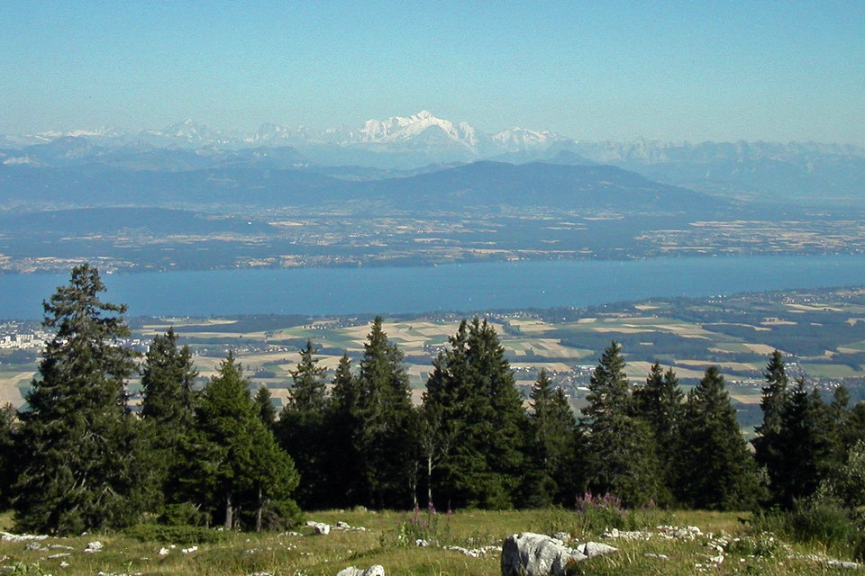
The summit rises to 4,809 meters in the heart of the Mont-Blanc massif and constitutes the highest point of the chain of the Alps. It is also the highest peak in Western Europe, earning it the nickname “Roof of Europe”. However, if we consider that this continent extends as far as the Caucasus, then five main peaks – over 500 meters in prominence – exceed it in the north or on the main watershed between the Russian territories and Georgians: the Elbrus which culminates at 5,642 meters, theDykh-Taou at 5,205 meters, the Chkhara at 5,193 meters, the Kochtan-Taou at 5,150 meters and Mount Kazbek at 5,147 meters. By its topographic prominence of 4,696 meters against the Volga-Baltic Canal to 113 meters in Russia, he arrived just behind Elbrus (4741 m) in Europe and 11 global position of peaks ultra prominent.
Mont Blanc dominates in particular Mont Maudit (4,465 m) and the Aiguille du Midi (3,842 m) to the north-northeast, the Grandes Jorasses (4,208 m) to the east-northeast, the Mont Blanc de Courmayeur (4,748 m) to the south-east and the Goûter dome (4,304 m) to the north-west. It straddles the Arve valley to the north and the Vény valley to the south.
The theoretical panorama, depending on the relief and the earth’s curvature but not on refraction phenomena, covers six massifs from the summit of Mont Blanc: the Massif Central (mountain of Aulas and Mont Aigoual in the south of the Cévennes at 326 and 321 km, Cassini peak in Mont Lozère at 286 km, Mont Mézenc at 233 km, Mont Mouchet in the Margeride at 289 km, Crêt de la Perdrix in Pilat at 185 km, Puy du Rocherand Peyre-Arse in the Cantal Mountains at 332 and 335 km, Lyonnais Mountains at 185 km, Pierre-sur-Haute and Puy de Montoncel in the Forez Mountains at 239 and 247 km, Puy de Dôme in the chain des Puys at 304 km, Mont Saint-Cyr in the Mâconnais at 197 km), the Morvan (Haut-Folin at 253 km, Tureau des Grands-Bois at 258 km), the Jura, the Vosges (Grand Ballon 231 km), the Black Forest (Belchen 233 km, Feldberg 243 km) and the Apennines (Mount Penice 225 km, Mount Ragola 252 km, Mount Ebro 221 km). However, it is not always easy to distinguish the most distant mountains, even in sunny weather. The pollution emitted in the plains combined with the absence of wind can reduce the good visibility to 100 km.
Mont-Blanc massif
The Mont-Blanc massif is an Alpine massif shared between France, Italy and Switzerland. It is home to Mont Blanc, the highest peak in Western Europe which rises to 4,809 meters (altitude recorded in 2015). It is crossed by the Mont-Blanc tunnel, between Chamonix in the Arve valley and Courmayeur in the Aosta valley.
This massif is relatively small in area since it extends over only about 400 km 2, but it encroaches on three countries: it is located largely on the French department of Haute-Savoie, but also of Savoie, on the Aosta Valley in Italy and the canton of Valais in Switzerland.
The massif, because of its altitude and the small number of valleys intersecting it, is uninhabited. Indeed, the glaciers occupy the depressions down to the valleys, and the torrents they feed are not enough to erode the massif. It is surrounded by the Arve valley to the west, and to the east by a succession of valleys paralleling the massif: from north to south, the Trient valley and the Swiss Val Ferret in Valais, the Val Ferret Italian and Vény Valley in the Aosta Valley and finally the Valley of the Glaciers in Savoy.
We can divide the massif into several zones:
the domes of Miage and Tré la Tête;
the central group, which includes the summit of Mont Blanc itself;
l ‘ aiguille Verte, the Drus;
the Aiguilles de Chamonix, from the Aiguille du Midi to the Aiguille des Grands Charmoz;
the Grandes Jorasses;
the Argentière needle group.
The main valleys that surround it are connected by the Mont-Blanc tunnel and the Petit-Saint-Bernard pass (between Italy and France) and the Montets pass via Vallorcine (between France and Switzerland). In fact, the Mont-Blanc massif is highly equipped with tourist facilities, in order to welcome tourists from all over the world: there are five cable cars for the Chamonix valley alone, the most famous being the one climbing the Aiguille du Midi (3,842 m) and joining Courmayeur.
It is surrounded by the Aiguilles Rouges to the north-west (right bank of the Arve), the Giffre massif to the north, the Pennine Alps to the east, the Grée Alps to the south-east and the Beaufortain massif to the south-west..
Major peaks
These peaks are classified according to their altitude, from highest to lowest:
the Mont Blanc (4809 m)
the Mont Blanc Courmayeur (4748 m)
the mount Doom (4465 m)
the tip Louis Amadeus (4460 m)
the Goûter dome (4,304 m)
the Mont Blanc du Tacul (4248 m)
the Great Corner Pillar (4,243 m)
the Grandes Jorasses (4,208 m)
the Green Needle (4,122 m)
the Devil needles (4114 m)
the Blanche de Peuterey needle (4,112 m)
the Great Rocky (4,102 m)
the mount Fog (4069 m)
the Bionnassay needle (4,052 m)
the Needle of the Garden (4,035 m)
the Rochefort dome (4,015 m)
the giant’s tooth (4,013 m)
the tip Baretti (4013 m)
the Rochefort needle (4,001 m)
the Droites (4000 m)
the mount Mallet (3989 m)
the needle of Tré la Tête (3 930 m)
the Aiguille d’Argentière (3 900 m)
the Aiguille de Triolet (3,870 m)
the needle Taste (3863 m)
the Courtes (3,856 m)
the Aiguille du Midi (3,842 m)
the Grand Capucin (3,838 m)
the Black Tower (3,837 m)
the Aiguille du Chardonnet (3,824 m)
the Mount Dolent (3823 m)
the Aiguille des Glaciers (3,817 m)
the black needle of Peuterey (3,773 m)
the Aiguille de Leschaux (3,759 m)
the Drus (3,754 m)
the Aiguille de l’A Neuve (3,753 m)
the Aiguille de Talèfre (3,730 m)
the needle Plan (3673 m)
the domes of Miage (3,673 m)
the Crocodile’s tooth (3,640 m)
the Pain de Sucre d’Envers du Plan (3,607 m)
the Caiman tooth (3,554 m)
the Aiguille du Tour (3 544 m)
the Gros Rognon (3541 m)
the Aiguille de Blaitière (3 522 m)
the golden needles (3,519 m)
the Petite Aiguille Verte (3512 m)
the needle Fou (3501 m)
Main glaciers
The Mont-Blanc massif is home to the most important glaciers in mainland France. The best known, on the north side are the Mer de Glace, the Argentiere glacier, the Bossons glacier and of Tré la Tête.
French Glacier (north to south)
Glacier du Tour
Glaciers of Chardonnet, Milieu, Améthistes, Tour Noir (tributaries of the Argentière glacier)
Argentière Glacier (second glacier in the massif)
Glacier des Rognons (partly joins the Argentière glacier)
Pendent Glacier
Glacier du Nant Blanc
Charpoua glacier
Mer de Glace (largest glacier in the massif)
Talèfre Glacier
Leschaux Glacier (confluence with the Tacul glacier to form the Mer de Glace)
Tacul Glacier (descends from the Géant plateau; confluence with the Leschaux glacier
Periades Glacier (joins the Tacul Glacier)
Glacier des Nantillons (under the needle of Grands Charmoz)
Glacier de Blaitière (under the needle of the same name)
Glacier des Pèlerins (between Aiguille du Midi and Aiguille du Plan)
Bossons Glacier (descends from the summit of Mont Blanc)
Taconnaz Glacier
Tête Rousse Glacier (has a pocket of water under the ice)
Bionnassay glacier
Miage Glacier
Tré la Tête Glacier
Glacier des Glaciers
Italian glaciers (north to south)
Pré de Bar Glacier
Triolet Glacier
Gruetta Glacier
Frébouze Glacier
Grandes Jorasses glacier
Planpincieux Glacier
Toule Glacier
Brenva glacier
Freiney Glacier
Fog Glacier
Glaciers of Italian Bionnassay, Dôme and Mont-Blanc (join the Miage glacier)
Miage Glacier (largest Italian glacier in the massif)
Lée Blanche Glacier
Estelette Glacier
Swiss glaciers (north to south)
Glacier des Grands
Trient Glacier
Orny Glacier
Saleina Glacier
Treutse Bô Glacier
A Neuve glacier
Dolent Glacier
Geology
The Mont-Blanc massif is one of the external crystalline massifs of the Alps. It is essentially granitic, but there are also outcrops of gneiss, according to this distribution: the heart of the massif (Vallée Blanche) and the east (Tour glacier, Trient glacier) are in the granitic pluton while the western part (summit of Mont Blanc itself, Dôme du Goûter, the Tré la Tête sector) consists mainly of gneiss. They are in fact ancient Hercynian rocks taken from the Alpine orogeny.
The climate change may have effects on the geomorphology of the massif via the retreat of glaciers, but also via an accelerated collapse phenomena and avalanches in areas where the altitude rocks were maintained by water constantly jelly (” wall permafrost “, as has for example been studied on the west face of the Drus by the CNRS and the University of Savoie.
Topography
The summit of Mont Blanc is covered by a snow dome roughly elongated from west to east, while its slopes form a pyramid whose faces face north, south-west and south-east. The northern slope has a drop of 3,800 meters with the Arve valley. It mainly supplies the Bossons glacier; the Taconnaz glacier is born between the Aiguille du Goûter and the Dôme du Goûter, on the northwest ridge of Mont Blanc. The southwest and southeast sides, more rocky, have a maximum altitude of 3300 meters with the Val Veny just upstream of the frazione of Entrèves. They feed, from west to east, the Dôme glacier and the Mont-Blanc glacier, which both flow towards the Miage glacier, the Brouillard glacier and the Frêney glacier which are born below the summit and do not confluence more to the bottom of the valley, and finally the Brenva glacier.
Since 1863, following the topographic survey by Captain Jean-Joseph Mieulet, the official altitude of the highest peak in the Alps has long been 4,807 meters (geopotential ellipsoidal altitude), even if it has been refined to 4,807.20 meters by trigonometric leveling between 1892 and 1894 by cousins Henri and Joseph Vallot. Several measurement campaigns have been carried out since (the definition of the altitude having evolved, as well as the measurement techniques), concluding at an altitude between 4,807 meters and 4,811 meters. The altitude given is always that of the thick snow layer covering the summit. From the top to mid-height, it is covered with “eternal snow” (15 to 23 meters thick). The snowy peak moves randomly from year to year along the summit ridge, with a measured amplitude of more than nearly 35 meters. The rocky summit rises to 4,792 meters and is offset to the west from the snowy summit; thus, in 2004, it was, according to radar instruments and cores, 40 meters to the west of the latter, but since 2001 they have been more distant average.
Climate
Weather conditions can change very quickly (snow, fog). At the top, the wind speed can reach 150 km / h and the temperature −40 ° C (absolute minimum of −43 ° C). The wind reinforces the cold effect (wind chill): the apparent temperature drops by 10 ° C for every 15 km / h of wind. It can alone contribute to the failure of an ascent, even by professionals.
From around 3,700 m, all precipitation occurs as snow. The latter are more abundant in summer than in winter, because the cold air does not contain much moisture. The summit can experience a few thaw days a year, especially between July and September, the absolute maximum being 9 ° C). The zero degree isotherm can exceed 5,000 m in altitude.
Fauna and flora
In the Alps, the névés persist beyond 2,800 meters of altitude. The first slopes of Mont Blanc being located around 3,500 meters, they are therefore beyond the limit of the level nival. The significant snowpack and extreme climatic conditions make the living conditions of plant and animal species almost impossible.
However, at the lowest altitudes or in sheltered cliff hollows, certain plants manage to survive, such as the glacier buttercup, which can be found up to 4000 meters. However, the flora is essentially limited to mosses and lichens.
The mammals can not live under the conditions described, unlike some species of birds: chocards Chough, ptarmigan, Alpine Accentors and other alpine Niverolles.
Human Activities
Economy
The emergence of mass tourism generated by the influx of mountaineers or simple hikers (more followers of the Tour du Mont-Blanc) has been favored since 1945 by the revival of road infrastructure and by the boring of the Mont tunnel. -White. Despite the problems associated with overcrowding, this tourism generates direct economic benefits for the region which offset the costs of maintaining facilities (shelters, etc.) and emergency rescues. At the beginning of XXI century, Chamonix and summer sees daily presence of 100,000 tourists, and accommodation and transition. 25,000 people attempt to climb Mont Blanc every summer, between June and September,.
Different options allow you to climb Mont Blanc with or without an altitude acclimatization course. The activities of the Compagnie du Mont-Blanc extend over the entire massif. It was created in 2000 to bring together the ski areas of the different companies in the Chamonix valley and to merge all the ski lifts in the area. It employs 215 people (up to 260 with seasonal workers). The mountain also brings indirect economic benefits, with a revitalization of the region, for example with the installation of many companies linked to winter sports in the Chamonix valley.and the doubling of the number of brands and stores.
“Mont Blanc” label
The “Mont Blanc” label is buoyant, to such an extent that companies with no apparent direct link have chosen a similar name. Since 1906, the German company Montblanc (Montblanc International GmbH) has first marketed pens, then watches, leather goods, glasses and perfumes. The brand is registered. The strongest symbol of the brand turns out to be undoubtedly the stylized six-pointed white star, each branch of which represents a glacier in the massif. The number 4810 is also a recurring element.
The Tonimalt drink, formerly made from malt, milk, honey and cocoa, today marketed by Nestlé, was sold under the Mont Blanc appellation and the box label represented this peak. Mont Blanc dessert creams are manufactured by the Chef-du-Pont (Manche) dairy, acquired by Activa Capital in 2003 from Nestlé. Since 2006, the company has also been offering gourds and ice cream bars.
Tourism
With 15 million tourists a year, Mont Blanc is one of the most visited places in the Alps. Since centuries past, the attraction generated by the beauty of the surrounding mountains and valleys has always been remarkable. Beginning in 1741, the tales of the English aristocrats William Windham and Richard Pococke about their journey on the Sea of Icethey spread throughout Europe arousing great curiosity. In a short time, wealthy tourists, for the most part English, arrived in the remote mountain centers of the Kingdom of Sardinia to admire the mysterious glaciers and the peaks of the untouched mountains. Those mountain villages are considered to be one of the places where tourism itself was born.
First the winter tourism and then later also the summer one as a direct consequence of the unexpected race to conquer the inaccessible and untouched peaks. The opening of the first hotel in Chamonix in 1770 started the development of the hotel industry. Luxury hotels followed and together with Courmayeur they became one of the most sought-after holiday resorts, frequented by nobles, writers, scientists and the first mountaineers, even before tourism itself became a mass phenomenon.
Mountain Guides
The environment of Mont Blanc, due to its vastness and its historical importance, being a destination for explorers and mountaineers since the end of the eighteenth century, gave a great boost to the birth of the profession of mountain guide. Here the first guide companies were born:
the Compagnie des guides de Chamonix, born on July 24, 1821, was the first company of guides in the world. On 9 May 1823, through a manifesto of the Chamber of Deputies of Turin, the king of Sardinia, Carlo Felice di Savoia, made its creation official.
the Courmayeur Alpine Guide Society, founded in 1850, was the first Italian mountain guide company and the second in the world after that of Chamonix. Its historic headquarters became a museum in 1929: the Duca degli Abruzzi Alpine Museum where important relics from expeditions not only in the Mont Blanc massif but also in Tibet, in the Himalayas, in Africa, in India are collected. The guides distinguished themselves during the first attempts made to reach the summit of Mont Blanc starting from Courmayeur, but also during the climbs on the Matterhorn where they were protagonists withJean-Antoine Carrel and Jean-Joseph Maquignaz.
The Glaciers Cableway
In La Palud, near Courmayeur, the route of the Mont Blanc cable car begins, designed and conceived by the engineer Dino Lora Totino. In just under an hour you can reach Chamonix, France, completely bypassing the chain of the Alps. Initially conceived for mainly military purposes, it was inaugurated in the summer of 1947 and until 2015 it was divided into six different sections: from La Palud you can reach the Pavillon di Monte Frety at 2,175 m; continue to arrive at the Torino refuge at Colle del Gigante at 3,330 m, (almost 2,000 meters in eleven minutes); continue from Colle del Gigante to Punta Helbronnerat an altitude of 3,462 m from where you can enjoy a view of the entire Alpine arc: from the top of Mont Blanc to the Dente del Gigante, to the famous ” 4,000 ” of Europe such as the Matterhorn, Monte Rosa, Grivola, Gran Heaven. Continuing from Punta Helbronner we continue towards Aiguille du Midi, the highest point at 3,842 m; from the Aiguille du Midi it is possible to descend to Plan de L’Aiguille, at 2,137 m, to finally arrive in Chamonix. The cable car was completed in the sixties, and features some unique technical solutions, such as the suspended pylon.
Since 2011, renovation works have been carried out on the entire Italian section with the construction of a new departure station and the elimination of the one at the Torino Refuge, as well as the replacement of the cabins with more modern and safe structures. The works began on 10 April 2012 and ended on 29 May 2015. On 30 May 2015, the renovated cable car reopened to the public with the new name of SkyWay Monte Bianco. The second section of the new cable car leads directly from the Pavillon di Monte Frety to Punta Helbronner. In this way, the intermediate stage at the Torino refuge is avoided, so the entire crossing is now divided into only five sections, and no longer six as before.
Mountaineering
The massif is one of the most popular places in France and in Europe for the practice of mountaineering thanks to races of all levels. Nowadays, this summit welcomes nearly 20,000 climbers each year and up to 500 climbers on certain days. The most frequented route, the normal route via the Goûter refuge, is considered long but ” not very difficult ” for a trained mountaineer who is acclimated to altitude.
The remoteness and the objective dangers of an ascent nevertheless present risks. As with any mountaineering race, this one should not be done without a good knowledge of the high mountains, without physical preparation and adequate equipment. The normal route notably presents delicate passages such as the Goûter corridor with rockfall. The high altitude exposes the mountaineer to acute mountain sickness which can lead to death; prior acclimatization to altitude is necessary.
The high attendance of Mont Blanc explains the large number of incidents compared to other alpine summits. Each year, the ascent of Mont Blanc thus claims many victims (5 to 7 deaths per year for the normal route). 120 interventions were carried out in 2006 by the high mountain gendarmerie platoon (PGHM), 80% of which was for exhaustion (poor physical preparation, lack of acclimatization); 30% of mountaineers present with injuries (frostbite, crampon injuries, altitude related disorders) on their return to the refuge. The success rate is only 33% without the help of a guide (50% with). Despite all this, 2,000 to 3,000 people successfully climb the climb each year.
Some agencies now offer beginners courses of a few days including an introduction to mountaineering, a period of acclimatization to the altitude and the ascent of Mont Blanc under the direction of a professional (mountain guide). This concept, allowing the practice of a new form of mountaineering “without a future” puts an end to a certain philosophy of the mountain according to which the ascent of Mont Blanc would be aimed at mountaineers already experienced and familiar with the techniques of mountain climbing. mountaineering. The experience feedback in this field does not confirm, at this stage, the relevance of such an approach to the mountains or the probability of success in a company where the stated objective remains a trophy hunt rather than.
Different routes
There are some routes for climbing Mont Blanc:
Normal routes
There are four normal ways:
the route of the Grands Mulets to the north, 2,500 meters in altitude and difficulty PD. The first ascent of the Grands Mulets route and the Bosses crest was made on 29 July 1859 by E. Headland, GC Hodgkinson, C. Hudson and GC Joad with Melchior Anderegg, François Couttet and two other guides.
the French normal route to the north-west, 2,450 meters in altitude and difficulty PD-. The first ascent of this route, from Aiguille du Goûter to the Dôme pass, was made on 17 September 1784 by Jean Marie Couttet and François Cuidet. The complete ascent to Aiguille du Goûter, the Dôme du Goûter and the Bosses crest was only completed on July 18, 1861, more than seventy years later, by Leslie Stephen and Francis Fox Tuckett with guides Melchior Anderegg, Johann- Josef Bennen and Peter Perren.
the Via dei Trois Mont Blanc to the north-east, 1,700 meters in altitude and difficulty PD +. The first ascent was made on 13 August 1863 by Robert William Head with the guides Julien Grange, Adolphe Orset and Jean-Marie Perrod.
the Italian normal route to the south-west, 3,210 meters of altitude and PD + difficulty. The itinerary was traveled downhill for the first time on 1 August 1890 by Luigi Graselli, Giovanni Bonin and Achille Ratti, the future Pope Pius XI, with the guides Joseph Gadin and Alexis Proment. The climbers had come up from the Spur of the Tournette.
South side (Frêney-Brouillard)
Cresta di Peuterey – 14-16 August 1893 – First ascent by Émile Rey, Christian Klucker, César Ollier, Paul Güssfeldt. The only top of the Peuterey ridge, beyond the Grand Pilier d’Angle, had already been climbed by James Eccles, Michel-Clement and Alphonse Payot in 1877, coming from the Eccles couloir.
Cresta del Brouillard – 18-20 July 1901 – First ascent by Giuseppe Gugliermina, Giovanni Battista Gugliermina and Joseph Brocherel.
Cresta dell’Innominata – 19-20 August 1920 – First ascent by Adolphe Rey and Henri Rey, Adolf Aufdenblatten, SL Courtald and EG Oliver, 800 m IV / D.
“Cresta dell’Innominata” – 25 March 1953 – First winter ascent by Gigi Panei and Sergio Viotto.
Cresta Integrale di Peuterey – 24-26 July 1953 – First ascent by Richard Hechtel and Günther Kittelmann.
Side of the Brouillard
Via Bonatti-Oggioni to the Red Pillar – 5-6 July 1959 – First ascent by Walter Bonatti and Andrea Oggioni, 400 m / TD +.
Hypercouloir del Brouillard – May 13-14, 1982 – First ascent by Patrick Gabarrou and Pierre-Alain Steiner, 700 m V / 6
Direttissima Gabarrou-Long to the Red Pillar – 28-29 July 1983 – First ascent by Patrick Gabarrou and Alexis Long, 400 m / ED +.
Hypergoulotte – 20 April 1984 – First ascent by Benoît Grison and Lionel Mailly, 400 m V / 6 +.
Notre Dame Waterfall – 14-15 October 1984 – First ascent by Patrick Gabarrou and François Marsigny, 700m V / 6.
Innominette – 9 July 1985 – First ascent by Patrick Gabarrou and Alexis Long, 700m V / 5.
Modern classical to the left pillar – 1st August 2011 – First ascent by Hervé Barmasse, Iker Pou and Eneko Pou, 300 m / 6c.
Side of the Frêney
Couloir Eccles and the top of the Peuterey ridge – 30-31 July 1877 – First ascent by James Eccles, Michel-Clement and Alphonse Payot (first ascent of Mont Blanc from the south side).
Via Bollini-Gervasutti to the North Pillar of Frêney – 13 August 1940 – First ascent by Giusto Gervasutti and Paolo Bollini della Predosa, 700 m / TD.
Via Bonington (or classic route) to Frêney Central Pillar – 27-29 August 1961 – First ascent by Chris Bonington, Ian Clough, Jan Djugloz and Don Whillans, 500 m / TD +.
Via Frost-Harlin to the Frêney Hidden Pillar – 1-2 August 1963 – First ascent by Tom Frost and John Harlin, 300 m / ED.
Via Seigneur-Dubost to the Frêney South Pillar – 25-26 July 1972 – First ascent by Yannick Seigneur and Louis Dubost. This is the first integral ascent of the South Pylon, previously only partially ascended.
Gran couloir del Frêney – 30 July 1974 – First ascent by Guy Albert, Jean Afanasieff, Jean Blanchard and Olivier Challéat, 850 m III / D.
Freney Waterfall – 3 September 1980 – First ascent by Gian Carlo Grassi, Marco Bernardi and Renzo Luzi, 100 m IV / 5 +. It is a waterfall of 80 meters, starting at 4,500 m. It represents the direct exit of the Gran couloir del Frêney.
Via Jöri Bardill to the Frêney Central Pillar – 10-12 August 1982 – First ascent by Michel Piola, Pierre-Alain Steiner and Jöri Bardill, 500 m / ED 6c. It is a very direct route that climbs the left corner of the Central Pylon.
Frêneysie Pascal – 20-21 April 1984 – First ascent by Patrick Gabarrou and François Marsigny, 700 m VI / 6. The road climbs along the gullies to the right of the Central Pylon.
Abominette – 25 April 1984 – First ascent by Patrick Gabarrou, Christophe Profit and Sylviane Tavernier, 700 m IV / 3. The route climbs to the extreme left of the Frêney side, between the Innominata ridge and the South Pilone. It is the least difficult route on the slope.
Fantomastic – 4-5 April 1985 – First ascent by Patrick Gabarrou and François Marsigny, 700 m V / 6. The route climbs along the couloir between the South Pylon and the Hidden Pillar.
Jean-Chri al Pilone Nascosto del Frêney – 2007 – First ascent by Patrick Gabarrou and Christophe Dumarest of a second route on Pilone Nascosto, 800 m / 7a + A1.
East side (Brenva)
Sperone della Brenva – 15 July 1865 – First ascent by Adolphus Warburton Moore, George Spencer Mathews, Frank Walker, Horace Walker and the guides Jakob Anderegg and Melchior Anderegg, 800m IV / 1, 4c.
6 August 1933 – First solo by Leopoldo Gasparotto.
February 26, 1956 – Jean Couzy and André Vialatte’s winter premiere.
Via della Sentinella Rossa – 1-2 September 1927 – First ascent by Thomas Graham Brown and Francis Sidney Smythe, 1300 m V / D.
March 9, 1961 – Walter Bonatti and Gigi Panei’s winter premiere.
Via Major – 6-7 August 1928 – First ascent by Thomas Graham Brown and Francis Sidney Smythe, 1300 m V / 2 4b.
13 September 1959 – First solo by Walter Bonatti.
Via della Poire – 5 August 1933 – First ascent by Thomas Graham Brown, Alexander Graven and Alfred Aufdenblatten, 1300 m V / 1 4c.
13 September 1959 – Carlo Mauri’s first solo.
February 8-9, 1965 – Winter premiere of Alessio Ollier, Attilio Ollier and Franco Salluard.
South-west side
Sperone della Tournette – 2 July 1872 – First ascent by Thomas Stuart Kennedy, Jean-Antoine Carrel and Johann Fischer, 1000 m III / AD 3c.
Couloir Greloz-Roch – 9 August 1946 – First ascent by Robert Gréloz, André Roch and Ruedi Schmid, 1100 m IV / AD.
Downhill skiing
Couloir Saudan – 25 June 1973 – First descent of Sylvain Saudan. It represents the first descent of the southwestern side of Mont Blanc.
Sperone della Brenva and Güssfeldt variant – 30 June 1973 – First descent by Heini Holzer.
Gran couloir della Brenva – 28 April 1978 – Toni Valeruz’s first descent in 35 minutes. The ascent took place by helicopter.
Via Major – 7 September 1979 – First descent by Stefano De Benedetti. Uphill and downhill he is accompanied on foot by Gianni Comino.
Couloir Greloz-Roch – September 1980 – First descent by Stefano De Benedetti.
Gran couloir del Frêney – July 1981 – First descent by Stefano De Benedetti.
Cresta dell’Innominata – 11 June 1986 – First descent by Stefano De Benedetti.
Environmental protection
The site of the Mont Blanc massif is the subject of a draft ranking on the list of World Heritage of the UNESCO as “one exceptional site in the world” and as a cultural Mecca, birthplace and symbol of mountaineering. This project is not shared by all and should be the subject of joint requests from the three French, Italian and Swiss governments.
The overcrowding threshold for Mont Blanc has been reached, with 300 to 400 departures per day in summer. During the summit of the National Mountain Council held in Sallanches,Aug 2006, it has been estimated that 25,000 to 30,000 people set out in 2005 to conquer Mont Blanc. With the opening of new markets (Russia, China, India), 50,000 to 100,000 people could attempt the adventure tomorrow, the figure of 200,000 having even been put forward. These prospects are nightmarish for the defenders of the site and for some politicians in the valley, such as the mayor of Saint-Gervais-les-Bains., municipality in which Mont Blanc is located. During the summer of 2003, with the drought and increased use of the site, several tens of tons of rubbish and various waste were left by the climbers who were camping in the area of the Goûter refuge. In 2002, the Pro-mont Blanc association published the book Le versant noir du mont Blanc, which outlines the current and future problems that arise to keep the site as it is.
According to Jean-Marc Peillex, the mayor: “It was more open-air toilets than a glacier. Yet we are in a classified site where, according to the law of 1930, camping is prohibited. And despite everything, we are leaving dozens of climbers to settle down and pollute our water reservoir of tomorrow. ” According to the guard of refuge: ” These people who sleep in tents are mostly foreigners, have little means and cannot necessarily afford the 25 euros per night in a refuge [in 2013, the night without meals costs 60 €]. So they sometimes camp for several days while waiting for a favorable weather window. There are some who are respectful of the mountain, who take their waste back to the refuge, come to our toilets and others who leave their bins on this improvised campsite.
The mayor of Saint-Gervais-les-Bains has proposed the establishment of an ascent permit – as is done in Nepal -, the issuance of which would be linked to the number of places available in the Goûter shelters – which will be enlarged with the construction of a new building – and the Red Head. However, some mountaineers, including some very well known, are against the idea of this ascent permit, which would be contrary to their freedom. According to the president of the guides: “The mountain must remain a space of freedom… Everyone must be able to reach the summits without financial constraints. Many colleagues would probably never have become guides if such a regulation had existed “, and the famous mountaineer, Christophe Profit, even calls for the elimination of shelters: “Because if people pitch their tents up there, it’s because there is accommodation nearby. Without refuge, the problem would be solved. ”
Since 2019, a nominative reservation system has now made it possible to regulate the number of refuges located on the access roads to Mont Blanc, until then a victim of overcrowding and pollution, and to better distribute the public to the various refuges.