Kalk is the 8th district of Cologne. It includes the districts of Brück, Höhenberg, Humboldt / Gremberg, Kalk, Merheim, Neubrück, Ostheim, Rath / Heumar and Vingst. District 8 was founded as part of a municipal reorganization on January 1, 1975 and bears the name of its most populous district Kalk. At the time of the old postcode system, the districts of the district were incorporated under 5000 Köln 91.
The city district borders in the north on the city district Mülheim, in the east on the cities Bergisch Gladbach and Rösrath, in the south on the city district Porz and in the west with Deutz on the city center district.
Kalk has always fascinated the hip Cologne city-center dweller: urban density, inspiring fallow land, cheap rents, a colorful mix of cultures. While Ehrenfeld became the new Kiez, Kalk did not come despite all that, even though it is just as close to the city. The fall from a prosperous industrial suburb to a crisis-ridden social hot spot, great things happening in this district full of potential.
The west of Kalk, once the location of the chemical factories, has changed its face more radically than almost any other part of Cologne. One of the largest shopping centers in the city, the largest police headquarters in Europe, the “Odysseum” adventure museum, new office buildings with surprising architectural quality, specialty stores such as the Music Store and one of the largest hardware stores in Europe are located here.
There is a high-quality residential area here, surrounded by a large park. Significantly more academics and media people are moving in. The west of Kalk has become an alternative quarter to the city center, especially for the sought-after and expensive Deutz. The prices for rents and condominiums are rising accordingly.
The retail sector has also picked up significantly. Even the old Kaufhof will soon reopen its doors under the new concept as “Kalkhof” and offer plenty of space for various shops such as Rossmann and Kaufland. The parking spaces of the “KölnArcaden” shopping mall are used by quite a few visitors from the Bergisches Land to take the underground to the city. A visit to Kalk itself is also worthwhile – there is Cologne’s oldest brewery with a huge beer garden and cellar, a well-known pilgrimage chapel and appealing gastronomy, such as the “Blue King”, an institution in the Veedel. And a nice substitute for missing parks is the Alte Friedhof Kalk, a gem from the century before last.
In the south there is a huge industrial and commercial park in which old halls have been preserved. Some are still in operation, others are climbing gyms, offices, laboratories, workshops or lofts. Largely unnoticed by the rest of Cologne, many dynamic startups have settled here and in neighboring Gremberg. The residential area around the Trimbornstrasse S-Bahn station is changing accordingly. There are still many old buildings here, some of which have already been spruced up. Kalk is one of the few districts on the right bank of the Rhine that corresponds to the coveted “inner city residential type” – and is also gaining in student flair, thanks to the nearby Technical University in Deutz.
Subdivisions
Kalk consists of nine Stadtteile (city parts):
Brück district
Brück is located on the eastern edge of the Cologne city area and on the edge of the popular local recreation area Königsforst. The town of Brück, mentioned in a document since 1166, belonged to the Merheim messenger office in the Duchy of Berg before 1800, to the mayor’s office of Merheim in the Mülheim / Rhein district in the 19th century and has been a district of Cologne since 1914. In 1965 the foundation stone was laid for the construction of the “Konrad-Adenauer-Siedlung” in the west of Brück. This settlement was separated from Brück in 1992 as a separate Cologne district “Neubrück”.
The population of Brück remained almost constant between 1880 and 1920 at around 1,500 people. At the beginning of the 20th century, as contemporary sources show, life in Brück was rather modest. In addition to agriculture, only a few companies, such as silk weaving or brickworks, offered jobs. With the construction of the major railway lines and the emergence of the Cologne industrial suburb of Kalk, Brück had completely lost its importance at the intersection of two supraregional trade routes – Olpener Straße and Mauspfad.
In 1906, Brück was connected to Cologne by a small railway. Through this connection and a settlement policy promoted by the city, there was a fundamental social restructuring in the following decades up to around 1960: Numerous Cologne employees and civil servants with their mostly young families moved in, which is why the population increased sixfold during this time.
Unlike the long-established population of Brück, this group of people who had moved in no longer had their job in Brück.The settler families found their social ties beyond work on the one hand in the neighborhood, on the other in numerous associations and in the institutions of the two churches. Also through the acquisition of their own land and the constant expansion of their houses, partly by the next generation, these families feel closely connected to their hometown.
In the years after 1960 the population of Brück only increased slightly. There was growth through young families with children who moved into new buildings on the western edge of Brück and in the center of Brück, which was structurally densified.
Sights
The then elector had a chapel built as early as 1708. It was initially dedicated to Saint Anthony and from 1716 it served as the Hubertus Chapel. This Hubertus chapel was rebuilt in 1864 and served as a Catholic parish church from 1889. In 1930/31 the Catholic St. Hubertus Church was built. Today the parish belongs to the parish community of Brück / Merheim with St. Gereon in Merheim.
In 1936/37 the Protestant Johanneskirche was built. Today the church is the center of the Evangelical Church Community in Cologne-Brück-Merheim
Humboldt/Gremberg district
The two districts of Humboldt and Gremberg, located south of the Kalk district, initially developed differently. Today’s Humboldt was assigned to the Deutz administrative district and was thus also incorporated into Cologne in 1888. In contrast, the district of Gremberg belonged to the municipality of Vingst and was therefore incorporated into Cologne with Vingst in 1910.
The nucleus of Gremberg, the Gremberger Hof, was mentioned in a document in the deed of donation from Archbishop Heribert to the Deutz Abbey in 1003. The nearby forest, the Gremberger wood, was a popular destination in Cologne until the end of the 19th century. After that, Gremberg developed into a residential location for the Kalker factories.
In the 1950s, the district was expanded with multi-storey rental blocks, so that Gremberg grew more and more together with Humboldt. Due to the up-and-coming industry in neighboring Kalk, there was a need for housing for workers in Humboldt and Gremberg. This was particularly true of the rapidly expanding machine factory, the “Machinenbauanstalt Humboldt”, which, as is customary in mining, was traditionally named after a famous personality, the natural scientist Alexander von Humboldt.
It was decided to build a workers’ settlement on the open field south of Kalk, which then belonged to Deutz. This settlement, the “Humboldt Colony”, was further developed by the architects Fabricius and Hahn in the 1920s with two- and three-story rental apartments. Two churches and two schools were built and a park was created. Even after the Second World War, the settlement grew continuously.
University of Applied Sciences for Media and Information Technology, Forsthaus im Gremberger Wäldchen, Georg-Simon-Ohm-Schule, Wilhelminian style houses on Hachenburger Strasse / Taunusstrasse, Humboldtpark, Rechtsrheinisches Technologiezentrum (RTZ) on Rolshover Strasse, Sankt Engelbert and Sankt Marien
Sights
Humboldtpark
The Humboldtpark in the Cologne district of Humboldt / Gremberg is a 2.2 hectare listed green space and one of the few inner-city facilities in the Kalk district. The park is located in the western part of the Humboldt Colony, which is separated by a freight railway line towards the Deutz district. The triangular park is accessed by circular paths and is now surrounded by tall trees, plane trees and chestnuts. There is a playground in the open space in the middle. There are also flower gardens. A piece of kitchen and school garden has been replaced by a boules court.
Höhenberg district
“Höhenberg” was originally the old topographical name for an elevation in the southwestern tip of the former mayor’s office of Merheim. The Höhenberg was a section of a ridge that reached from Gremberg, over the Marberg in the Vingst district, over the Höhenberg to the Emberg in the Höhenhaus district. In 1989, committed Höhenbergers developed a corresponding emblem to promote their homeland. At the same time, it is linked to the hope that confusion with the “Höhenhaus” district will be less.
Höhenberg is centrally located between the districts of Kalk, Merheim, Vingst and Buchheim. The favorable location is illustrated by traffic arteries such as Frankfurter Strasse, Olpener Strasse, the motorway-like federal road 55a as a connection between the Cologne-Ost motorway junction and the Zoobrücke, the A3 federal motorway and two tram stops.
The area was almost undeveloped until the middle of the 19th century. After settlement in the first decades of the 20th century, Höhenberg became a district of Cologne in 1927. The first buildings at the intersection of Frankfurter Strasse and Olpener Strasse were not erected until around 1830. At the beginning of the 20th century, the first multi-storey apartment buildings were built for the employees of the Kalker and Mülheim factories. Höhenberg’s growth got a boost in the 1920s: The non-profit public limited company for housing (GAG) built one of the largest contiguous housing estates in Germany on the site of the former Germania blast furnace. 1,500 apartments were built on 17 hectares. Several smaller settlement projects followed. Even after the Second World War, this development continued into the 1970s.
The structural change in Cologne on the right bank of the Rhine, which was characterized by the breakdown of industrial jobs, led to an increased proportion of unemployed in the traditional working-class neighborhoods and in the 1980s brought increasing social problems. On the initiative of the Catholic and Protestant parishes, the HöVi-Land holiday camp was first initiated in 1994 for children from socially disadvantaged families. This resulted in a social network which, in addition to supporting those in need, also aims to improve the cleanliness and beautification of the Höhenberg and Vingst districts.
Höhenberg has also developed into a carnival stronghold with tent sessions and street carnivals. Thousands of jackets line the train path on Carnival Saturday and sway with them. Every year since 1987, people meet for the Veedelsfest on Weimarer Strasse in summer.
Sights
St. Elisabeth
The three-aisled brick hall church of St. Elisabeth was built between 1908 and 1910 and consecrated on December 18, 1910 in honor of St. Elisabeth of Thuringia by Dean Martin Köllen. The architecture of the church combines late Gothic and Romanesque forms. The interior was furnished with themed glazing, side altars and figures of saints. The church was given the spire, the organ and a tower clock that is no longer in existence until after the consecration in the period up to the Second World War. After bombers had badly damaged the church in World War II, it was only opened in 1956/57 according to plans by Dominikus Böhmand his son Gottfried Böhm repaired and expanded at the same time. The altar, the tabernacle, the six altar candlesticks and the six meter high stand cross were made by Hanns Rheindorf in 1956. Between 1959 and 1968 the same Cologne artist designed a marble baptismal font, the stations of the cross made of enamel and an Easter candlestick. St. Elisabeth received a new organ in 1968. Much of the church glazing designed by Dominikus Böhm was replaced between 1982 and 1988 by panes designed by the painter Hans Rolf Maria Koller.
Mülheimer Friedhof
The park-like Mülheimer Friedhof on Frankfurter Strasse, which opened on September 30, 1904, has an almost triangular, almost 20 hectare area. The cemetery was created by the then still independent city of Mülheim am Rhein as a city cemetery, where both Protestant and Catholic Christians were to be buried. The three-part entrance gate, densely covered with ivy, was built according to plans by the Mülheim government master builder Raabe in 1903 and is a listed building. The wide main path, surrounded by old trees, leads to a roundabout on which the central high crosswas erected. The mourning hall and several large family graves are also located at this central point of the cemetery. Behind the mourning hall is an honorary grave field for those who died in the Second World War.
Kalk district
The place name of today’s Kalk district “Villa Kalka” is probably derived from the location of the settlement on the edge of a damp lowland (Kolk = swamp) and was first mentioned in a document in 1003 in a deed of donation from Archbishop Heribert to the newly founded Deutz Abbey. Individual courtyards in the area of today’s St. Joseph Church formed the original core of the settlement.
In the middle of the 19th century, Cologne companies avoided building in the vicinity of fortifications and around the medieval city wall “into the country”. Lime was particularly suitable, because the plots were still cheap here and there were no requirements with regard to building. The chemical and metalworking industries in particular became at home in Kalk. In 1881 the rural community became an independent city, and in 1910 a district of Cologne. As early as 1856, the “machine factory for mining by Sievers and Co. in Kalk near Deutz am Rhein” was established.
The Sievers machine factory became the “Maschinenbauanstalt Humboldt AG, Kalk near Cologne”, later the “Klöckner Humboldt Deutz AG ” (KHD), which has been operating as Deutz AG since 1997. At the same time, Julius Vorster and Hermann Grüneberg founded the chemical factory, which is still considered the epitome of lime today. These companies shaped the district until the end of the 20th century.
Kalk was 90 percent destroyed in World War II. After clearing the rubble and quickly rebuilding, many industrial companies resumed their work. From the 1960s onwards, many guest workers were hired due to the immense need for workers. The low rents near the factories led to a high proportion of migrants in Kalk.
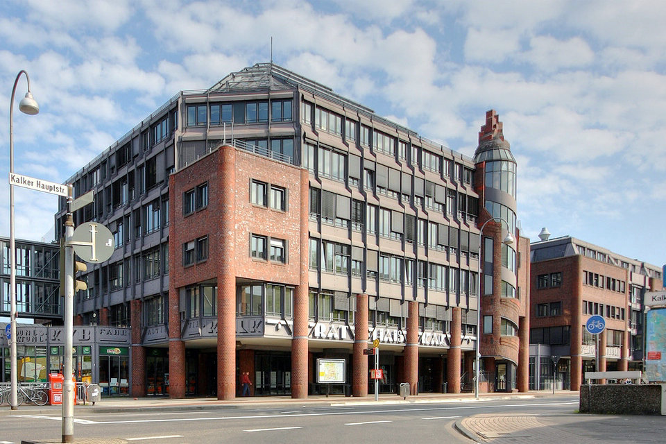
The recession in the 1970s and 1980s brought about a structural change in the district: in a few years, most factories reduced their workforce. After all, many factory gates closed forever. These changes brought high unemployment figures as well as unused factory and company premises as challenges for urban development. Little by little, the brownfield sites are being rebuilt, new businesses are emerging; the industry mix is changing. Among other things, the Köln Arcaden, a modern shopping center with a catchment area extending into the Bergisches Land, was built on the former site of the Kalk Chemical Factory.
Three projects illustrate Kalk’s function as an administrative location for the city district and all of Cologne: Not only the modern district town hall, which has been located opposite the Marienkirche and the Kalker Kapelle since 1992, but also the police headquarters, which moved from Waidmarkt to the former site of the Kalk chemical factory is. It is characterized by large windows and a fully glazed entrance hall. The nearby Kalk Karree houses offices of the city of Cologne, such as the central lost property office, the youth welfare office and the city call center.
In addition to these new and modern buildings, there are also historical sights that define the character of the district. These include, for example, the Kalk Stadtgarten, built between 1912 and 1913: It is located in the center of Kalk with direct access from Kalker Hauptstrasse. The 40 meter high water tower in the west of Kalks dates from 1904 and is one of the last remaining structures of the former Kalk Chemical Factory. Inside is a chimney from which white smoke used to rise.
Also directly on Kalker Hauptstrasse is the old brewhouse of the Sünner brewery, a brick building with neat gables, in which, among other things, the Kalker city coat of arms is depicted.
The district also enriches Cologne’s cultural offerings, including since 2009 with the Odysseum, a modern mix of science center, leisure park and research center. Children and young people learn there in a playful way.
The “Halle Kalk”, a former production hall of Klöckner-Humboldt-Deutz AG (KHD), is firmly established in Cologne theater life. It has been used by the City of Cologne’s theaters since 1994, primarily for experimental theater. The concerts in the atrium of the Kalk Karrees are also notable dates in Cologne’s cultural calendar.
From 1665 to 1666 a plague epidemic raged in the Rhineland. Since Kalk was spared her, a chapel was built in the years after the plague wave as thanks for the image of Mary from 1420. The wooden portrait of the Mother of God is said to have healing powers. The chapel was destroyed in the Second World War and rebuilt between 1948 and 1950. As a place of pilgrimage, it still attracts numerous pilgrims today.
Sights
Cultural heritage
Theater and cabaret: The Kalk Bürgerhaus is available for cabaret shows. In a former, listed production hall of the KHD-Werke on Neuerburgstrasse, the stage of the City of Cologne (Cologne Theater) set up the Kalk hall for experimental theater in 1994. This had to be closed in summer 2015 due to the risk of collapse. In July 2015, has German Cultural Council, the Halle Kalk on the Red List Culture set and classified as endangered (category 2).
Museum: After two years of construction, the Odysseum Science Experience Center opened in the northern part of the former site of the Kalk Chemical Factory on April 3, 2009. In the indoor and outdoor area, six themed worlds with 200 experience stations are offered for the areas of people, nature and technology. In addition, temporary special events are held.
Cinema: For several decades there was no cinema at all in Kalk, until the reopening of Lichtspiele Kalk in December 2017, the first cinema on the right bank of the Rhine in Cologne since the 1980s. The cinema is located on Kalk-Mülheimer Straße in the former rooms of the Union-Lichtspiele, which were closed in 1974. The Lichtspiele Kalk program includes not only current theatrical releases, but also classic and alternative films, such as B. the film series “Something Weird Cinema”.
Religious heritage
Kalker Kapelle, Kalker Hauptstrasse / Kapellenstrasse: After the war destruction, the place of worship was rebuilt from 1948 to 1950 as a simple brick building with one nave by Rudolf Schwarz and Karl Wimmenauer.
St. Marien, Kapellenstrasse: In the years 1863 to 1866, the parish church of St. Marien was built as a three – aisled neo – Gothic brick hall church with a tower over 50 meters high, based on plans by the Cologne diocesan master builder Vincenz Statz. The church was consecrated in 1867. The church was badly damaged during World War II. The reconstruction, including old parts of the building, took place from 1950 to 1952 according to plans by Rudolf Schwarz. In 1968/1969, windows were built into the church according to Georg Meistermann’s designs.
St. Joseph, Bertramstrasse: When St. Marien had become too small for the Catholic community in Kalk, the Kalker Catholics needed a second church. The three-aisled brick hall church of St. Joseph was built between 1899 and 1902 according to Heinrich Renard’s plans. The historical nucleus of the municipality of Kalk between Höfe and Engelstrasse was selected as the location. St. Joseph was also destroyed in the war and rebuilt in a greatly simplified form according to the plans of Dominikus and Gottfried Böhm.
Jesus Christ Church, Lilienthalstrasse: As the chemical factory needed new building ground for an extension, the Evangelical Presbyter Church on Vietorstrasse, built in 1880, was demolished. The church was replaced by the new building of the Jesus Christ Church on Buchforststrasse, which was inaugurated on December 23, 1951.
Klarissenkloster, Kapellenstrasse 51–53: Prelate Monsignor Martin Köllen and his niece, who was abbess in Kevelaer, came up with the idea of building a place of intense prayer in the pulsating lime. For this purpose, the Poor Clare Monastery was founded in 1918. As early as June 1918, the poor sisters of St. Clare of Assisi were able to move into a provisional monastery. In the following period, the monastery was built as a four-wing complex with an open inner courtyard and a central fountain and was consecrated together with the church on May 1, 1925. In 1941 the monastery was destroyed, but could be rebuilt in 1947. In 1965 figures were attached to the facades. In 1990 the monastery church was given colored glazing.
Industrial monuments
Brewery & distillery Gebrüder Sünner, Kalker Hauptstraße 260: The main building of the colliery brewery, erected between 1888 and 1890, was protected together with a building added in 1906 on July 26, 1983 as the oldest industrial monument in Cologne that was originally used. In addition, the responsible monument protection authority classified the carriage house built in 1898, the old forge from 1860 and the entire street-side fence as worthy of protection. In a renovation measure carried out between 1989 and 1991 and a cleaning initiated in 1999 with a final treatment with a hydrophobizing agentActive ingredient against the penetration of moisture, the facades of the buildings were brought into line with their original condition.
Water tower of the chemical factory Kalk on the area of the shopping center Köln Arcaden: The listed tower was built in 1904 and is 43.60 meters high. As a special feature, there is a chimney inside, which used to let white smoke rise from the top.
Former factory halls of the metal foundry Peter Stühlen in Peter-Stühlen-Straße
Factory chimney of the former KHD plant on Dillenburger Strasse, demolished in 2015
Former industrial halls on Dillenburger Strasse
Parks
In addition to the listed 0.6 hectare Stadtgarten Kalk on Kalker Hauptstrasse, designed by Fritz Encke in 1912 in Art Nouveau style, and the 3-hectare former town cemetery Kalk on Kapellenstrasse, between 2006 and In 2009 the 2.8 hectare Kalk Bürgerpark was laid out.
A clear deficit of green spaces has been identified in the urban development plan on the right bank of the Rhine, which is to be alleviated by connecting existing open spaces with different park typologies. The Kalkberg is an essential element for a coherent green area.
Merheim district
Merheim was an agricultural village for many centuries. Today it is an attractive residential suburb in the Kalk district. The place was first mentioned in documents in 1217, when Adolf von Berg sold an estate in Merheim to the Altenberg Abbey.
In the 6th or 7th century a Frohnhof was built here, to which a church soon belonged. In 1288 the Counts of Berg Merheim raised them to the office of messenger. It developed into the central church and place of pilgrimage to the Virgin Mary. In 1808 the mayor’s office in Merheim was established. It remained until it was incorporated into Cologne in 1914. The mayor’s office was located in a half-timbered house on Abshofstrasse, which was named after the mayor Bernhard Abshof.
The historic town center, surrounded by greenery and with classicist and baroque buildings, is unique in Cologne today. A market inn, today the oldest inn in Cologne on the right bank of the Rhine, was built in the Bergisch half-timbered style in 1665. Since 1937 it has been called “Em ahle Kohberg”, which can be traced back to a 1930 song by Willi Ostermann.
After the Second World War, the Cologne-Merheim municipal hospital was built on the site of the former Ostheim air base. In particular, the station for curing severely burned people made it known nationwide. A new residential area developed on the site of the former Madaus drug factory.
Merheim has good transport connections such as the federal road 55, motorway connections and the city train to the center. In addition, numerous supply facilities such as the KVB depot Merheim, a thermal power station and the Cologne city drainage company are located here. The Merheimer population finds relaxation in the Merheimer Heide.
Sights
The Catholic parish church of St. Gereon belonged to Cologne’s Gereonsstift. Gravestones found suggest a first Merovingian church that was connected to the Fronhof as a separate church. Later a Romanesque building was built, which was expanded several times. After the church collapsed in 1818, the current church was built by Johann Peter Weyer by 1821. This building was redesigned again in 1907 by Heinrich Renard. During World War IIthe original pointed church tower had to be shortened due to its location in the approach path to the Ostheim air base. At the beginning of the 1970s, the interior was redesigned according to the specifications of the Second Vatican Council.
In 1996 and 1997 the church was extensively renovated. The marble columns walled in in the 1970s were uncovered again. In 1997, the Christmas mass on Christmas Eve was broadcast throughout Germany on ARD television from St. Gereon.
Neubrück district
In the south-west of Brück is Neubrück, which was separated as a separate district by the Cologne City Council in 1992. It is a closed settlement that was built on the runway of the former Ostheim air base between 1965 and 1970.
When developing Neubrück, emphasis was placed on a mixture of one and two-family houses and multi-storey residential buildings, both for rent and as property. A lot of green between the buildings was also taken into account during the planning. The foundation stone for the new estate was laid in 1965 in the presence of the former Federal Chancellor Konrad Adenauer and the then Federal Minister of Construction Paul Lücke. Adenauer had previously intervened to bring movement into the sales negotiations for the land that the Federal Ministry of Defense had not previously wanted to release.
According to the modern architectural style of the 1960s, almost all buildings were built with flat roofs, which are still characteristic of the settlement today. Neubrück is a pure residential area with a direct connection to the A3 and A4 motorways.
In the center of Neubrück on Straßburger Platz are the Catholic and Protestant Churches, the Sparkasse, the district library, shops, medical practices and a residential and nursing home of the Deutschordens-Wohnstifts. The nearby Königsforst and the adjacent fields offer the people of Neubrück local recreation right on their doorstep.
Foundation stone of the settlement in Briandstrasse, youth center Neubrücker Ring, remnants of the former airport ring road of the Ostheim air base on Josef-Gockeln-Strasse, Sankt Adelheid and Trinitatiskirche
Sights
The foundation stone of the estate dated August 26, 1965 with the year “1965” engraved on the front of the single-family house at Briandstrasse 13
Remnants of the former airport ring road of the Ostheim Air Base on Josef-Gockeln-Straße, which is now used as a cycle path.
Metal sculpture in the school yard of the Kurt Tucholsky secondary school by an unknown artist
Ostheim district
Ostheim, which was mentioned in a document as early as 959, was a small village with few farms until the 19th century. It was located between the villages of Ensen and Merheim and belonged to the mayor’s office of Merheim, with which it was incorporated into Cologne in 1914. In the 1930s, with the construction of the Saar settlement, the development of the residential suburb for the neighboring industrial sites in Mülheim and Kalk began.
In the Servatius Church, consecrated in 1909, there is a stone from the previous building with the year 1707 on the threshold of the sacristy. In that year the first chapel was built, which was consecrated to Saint Servatius. It was built to seek protection from the typhus and marsh fever that came from the neighboring old arms of the Rhine.
After the Second World War, a further Catholic church “To the Holy Angels” and the Protestant Church of the Resurrection were added to the first church as a result of the rapid population growth. In 1937 the Wehrmacht opened a military airport whose facilities extended to today’s Neubrück. Since the Wahn airport was only about 10 kilometers away, the Allies saw no need to maintain the airport in 1945. The adjacent barracks buildings were therefore used by the Merheim municipal hospital or torn down.
Between 1950 and 1980 the population tripled as Ostheim became a popular residential area for the industrial sites in Mülheim and Kalk. In the 1950s, for example, a settlement for postal workers and the Baden district, named after the street name, with one and two-family houses were built.
At the beginning of the 1970s, high-rise buildings for more than 2,500 residents were built on the area of a former Prussian parade ground on Gernsheimer Strasse and praised as a model for social housing. Just a few years later, however, the buildings were increasingly felt to be unattractive. The street was neglect, which the city of Cologne countered with support programs and the increased use of street workers.
In the meantime, the non-profit housing company GAG not only renovated its housing stock from the 1950s, it also set a multi-award-winning accent with the new construction of the settlement on Buchheimer Weg. After the population had stagnated since the 1980s, it will rise again in the future through a new residential area in the south-western part of the city.
Sights
Religious heritage
The neo-Gothic simple brick church St. Servatius was built in 1906 according to plans by the diocesan master builder Franz Statz and consecrated on December 23, 1906. From 1962 to 1964 the nave was extended by two bays according to plans by the architect Kurt Faber. At the end of the renovation work, a marble altar was taken over from St. Peter’s Church in Cologne. Instead of a tower, a high bell rider was placed on the gable roof of the nave.
In 1960/61 the architects Josef Bernard and Fritz Schaller built the simple hall church to the Holy Angels on Buchheimer Weg. On the gable roof sits a bell rider with a pointed helmet, which has been crowned by an angel made of sheet copper since 1960. The organ with seven registers, built in 1868 by Franz Sonrek and thoroughly overhauled in 1965, was taken over by St. Servatius in 1977. All the windows in the church were designed by Paul Weigmann from 1986 to 1988.
The Protestant Church of the Resurrection in Heppenheimer Strasse was planned by the Hamburg architect Gerhard Langmaack and consecrated on March 21, 1954 after nine months of construction. The unadorned brick building with a pointed roof is plastered white. The striking square tower attached to the nave is crowned by a round helmet roof. There are twelve circular openings on each side of the tower, which ensure that the bells sound well.
Industrial monument
The steam power plant built in 1904 by the city of Cologne in the immediate vicinity of the tram stop lost its main task of supplying power to the surrounding districts as early as April 1, 1912, as the city concluded a long-term electricity supply contract with the Rheinische AG for lignite mining and briquette production. Today it serves as the RheinEnergie AG substation for feeding electricity into the Cologne light rail network. The Cologne transport company uses parts of the building as a building yard. Another part of the house serves as an artist’s studio. The gable walls are with the old Cologne coat of armsdecorated. The back of the coat of arms shows twelve flames in the lower field instead of the heraldic correct eleven.
Green areas
The 64-meter-high Vingster Berg, a wooded hill heaped up from rubble from the Second World War, is part of a green belt criss-crossed with walking paths that borders on Merheim, Höhenberg and Vingst. A circular route on the area of the former Plantage estate on Herkenrathweg runs past agricultural areas and numerous overgrown fruit trees. The large allotment garden Alter-Deutzer-Postweg is located in the southwest of the village.
Rath/Heumar district
The Rath / Heumar district is located on the eastern city limits of Cologne, directly adjacent to the Königsforst. Rath probably owes its name to clearing in the Königsforst (Rod). Heumar’s place name can be derived from humilis (small, low) and mar (swamp). The two places, which had grown together more and more after the Second World War, became a district of Cologne in 1975.
Rath / Heumar was dominated by agriculture until the 20th century. Even today, a few well-preserved half-timbered houses testify to this past. In addition to Haus Rath in the north and Haus Röttgen in the south, a large number of homesteads in a loose arrangement defined the townscape for a long time. Rath had belonged to the mayor’s office of Merheim since 1815 and was incorporated into Cologne in 1914. Heumar, which was the seat of a mayor’s office under French occupation in 1806, belonged to the Porz office in 1929 and came to Cologne with Porz in 1975.
In Rath began in the 1920s with the so-called Göttersiedlung (the streets are named after Germanic gods) the development of a green residential suburb. In Heumar, too, several settlements emerged, mostly with single-family houses. The rural area was opened to traffic in the middle of the 19th century through the expansion of Rösrather Straße. The Cologne-Königsforst railway connection has existed since 1904 (today’s Stadtbahn line 9), the end of which was Rath / Heumar for a while. Rösrather Straße developed into a handsome center for trade, commerce and good gastronomy.
Röttgen, which means “small clearing”, was created between the 9th and 13th centuries as a knight’s seat. In 1790 the old castle was demolished, in 1866 the castle complex was rebuilt as it is today: In the romantic style with recourse to the Middle Ages in the middle of a park and forest area. The complex was surrounded by a fortress-like wall with castle-like gate structures. In 1909, the Cologne water manufacturer Peter Mülhens bought the castle and founded a thoroughbred stud here in 1924, which is one of the most famous in Germany.
After the Second World War, the castle, which was badly damaged by bombs, was the seat of the British military government from 1945 to 1953. It was here that Chancellor Adenauer negotiated the German Treaty with the three Western occupying powers: England, France and the USA.
Sights
Röttgen Castle
Röttgen Castle is a complex with a castle and stud in the Cologne districts of Eil and Rath / Heumar. The castle and the approximately two square kilometers (250 hectares) area (roughly the size of Monaco ) are not open to the public. In 1970 a new forest law came into force in North Rhine-Westphalia, according to which every citizen should have access to all forests “for the purpose of recreation” and “at their own risk”. As a result, NRW Minister of Agriculture Diether Deneke triedin vain to have the wall dismantled; he considered it a “permanent provocation”. The Mehl-Mühlens couple invoked the exception paragraph, according to which “zoos and such forest areas are subordinate to special… commercial purposes” may remain blocked. If you open the wall, you have to close the stud. The SPD parliamentary group in the Cologne council decided not to extend the lease contract for the cycling track at Gut Leidenhausen, which in the meantime belonged to the city again, in order to exert pressure, but this was not carried out.
Many buildings on the grounds of Röttgen Castle are listed, including the castle itself, the wall, the gate guard house on the Mauspfad, the sawmill, the rent office, the stable buildings, the observation tower and the stable buildings planned by Wilhelm Koep in 1935, as well as the surrounding area Forest and the garden. Karen Künstler-Brandstädter wrote in 1998 as an employee of the Cologne city curator: “As an incomparable total work of art, which meets high technical and design standards and is presented in an almost completely preserved, original substance, Röttgen Castle is not only important for Cologne, but also represents also represents an outstanding monument of European standing nationwide. ”
Vingst district
Vingst is first mentioned in a deed of donation from Archbishop Heribert of Cologne to Deutz Abbey in 1003 as “Vinhem”. The origins of today’s Cologne district could, however, go back even further. The derivation of the name from the Latin word “vinitor” (winemaker) is likely. For many centuries, today’s Heßhofplatz was the center of the rural village, around which a village pond surrounded by small houses was located. The most important Vingster courtyards were, besides the Heßhof, the Unkelshof, the Gremberger Hof and the Vingster Hof, which is still preserved today. They all belonged to Deutz Abbey, but were temporarily leased.
The Electorate of Cologne was part of the district of Cologne in the 19th century. Due to the growing population and the increased importance, it received its own municipal administration in 1900 before it was incorporated into Cologne in 1910.
After the emergency church of Saint Mauritius was built in 1905, Vingst was separated from the parish of Kalk and, after incorporation in 1911, made an independent parish. From 1937 to 1939 the parish church of St. Theodor was built in place of the emergency church. It was destroyed and rebuilt in World War II. Unfortunately, the earthquake in April 1992 caused such severe damage that the church had to be demolished. Only the tower resting on its own foundations could be retained. The last new church building, one of the most modern churches in Cologne, was consecrated on March 16, 2002 by the Archbishop of Cologne, Joachim Cardinal Meisner. It is a rotunda designed by the architect Günter Böhm.
Sankt Theodor is the place of activity of the alternative Nobel Laureate Pastor Franz Meurer, who runs the HöVi -Land holiday camp every year with many volunteers for socially disadvantaged families in Vingst and Höhenberg. A social network was created from this initiative, which also aims to improve the beauty and cleanliness of the districts.
Until 1945 the center of Vingst had grown little. After the neighboring Kalk as well as the industrial Mülheim were badly damaged in the Second World War, much cheaper living space was needed in the short term. Vingst had large areas previously used for agriculture. Initially, simple transitional houses were built in the 1940s, but in the late 1950s, 1960s and 1970s social housing projects caused the population to rise rapidly.
With structural change, the number of unemployed increased and social problems developed. In addition, there was a great need for renovation of the rental blocks, some of which were provisionally built in a simple construction. Therefore, many of the typical residential buildings have been renovated since the early 1990s, at times more than 1,500 apartments. According to the measures, living in Vingst has become more attractive, including the actions of the network contribute resulting from the holiday camp HöVi arose place of birth, such as the action thriving HöVi. As part of the campaign, the green areas of Vingst and the neighboring Höhenberg were planted with flowers.
Sights
With the parish church of St. Theodor, the Catholic parish of Vingst has one of the most modern places of worship in the city of Cologne. In an earthquake on April 13, 1992, the old church was so badly damaged that it had to be demolished except for the tower, which rests on its own foundations. The new church was built according to plans by the architect Paul Böhm and was consecrated on March 16, 2002.
Since the church was damaged, the parish of St. Theodor has formed a community congregation with St. Elisabeth in Höhenberg, which is led by Pastor Franz Meurer.
Due to the poor social situation in Vingst and Höhenberg, Pastor Meurer introduced an exemplary social network that, among other things, supports a clothing store and food distribution for the socially disadvantaged, as well as the HöVi-Land summer vacation time, which is largely financed by donations.
A significant dialogue that describes Meurer as a person is as follows: At a symposium, the head of the Cologne health department stated: “ What use is it that a pastor distributes meatballs. We have to solve the problems structurally. ” Meurer replied briefly and succinctly: “ That is good and right, but such structural solutions have not been available for decades. And that’s how long I prefer to fry meatballs for everyone. ”
At the suggestion of the community, in March 2007, despite resistance from the Archdiocese of Cologne, he donated the collection of a DİTİB Sunday mass to help equip the new Cologne Central Mosque in Ehrenfeld.
In the neighborhood you will find the large senior citizens’ home at An St. Theodor. The sponsor has no economic connection to the parish.
The Protestant Church of the Redeemer of the Vingst-Neubrück-Höhenberg community was built in 1957 and offers space for 300 people. During the construction phase of St. Theodor, the Catholic community enjoyed the right to hospitality, so that Catholic services also took place in the Church of the Redeemer. A kindergarten and the “Blockhaus”, a youth facility, are attached to the church.