Intramuros (Spanish for “within the walls”) is the 0.67 square kilometers (0.26 sq mi) historic walled area within the modern City of Manila, Philippines. It is administered by the Intramuros Administration. The Intramuros Administration, a national government agency of the Republic of the Philippines established in 1979 is responsible for the restoration and redevelopment of the historic Walled City of Manila. The Administration boasts of an extensive collection of artifacts, of ecclesiastical and domestic nature, representing the Spanish Colonial Period from the 16th to the 19th centuries.
Intramuros is also called the Walled City, and at the time of the Spanish Colonial Period was synonymous to the City of Manila. Other towns and arrables (suburbs) located beyond the walls are referred to as “extramuros”, the Spanish for “outside the walls”. It was the seat of government and political power when the Philippines was a component realm of the Spanish Empire. It was also the center of religion, education and economy. The standard way of life in Intramuros became the standard way of life throughout the Philippines. The Manila Galleons which sailed the Pacific for 250 years, carried goods to and from Intramuros (Manila) and Acapulco, Mexico.
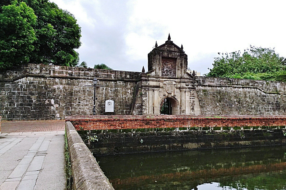
Construction of the defensive walls was started by the Spanish colonial government in the late 16th century to protect the city from foreign invasions. The Walled City was originally located along the shores of the Manila Bay, south of the entrance to Pasig River. Guarding the old city is Fort Santiago, its citadel located at the mouth of the river. Land reclamations during the early 20th century subsequently obscured the walls and fort from the bay. The Battle of Manila in 1945 devastated Intramuros. It is the place where the occupying Japanese Imperial Army made their last stand against American soldiers and Filipino guerillas. The battle destroyed its churches, universities, houses, and government buildings, most of which dated back to the Spanish Colonial Period.
Intramuros, particularly the Fort Santiago, was designated as a National Historical Landmark in 1951. The Intramuros Administration, created through Presidential Decree No. 1616 that was signed on April 10, 1979, is tasked to rebuild, redevelop, administer and preserve remaining buildings, structures and fortifications of Intramuros. San Agustin Church, a UNESCO World Heritage Site under the Baroque Churches of the Philippines, is located within Intramuros. A proposal has been suggested by scholars to make a separate UNESCO inclusion for the entire Intramuros district, which would include San Agustin Church. The same would be made for the other three churches listed in UNESCO, where each town plaza and surrounding heritage buildings would be added. The move would separate the 4 properties of the site and would fruit into 4 distinct UNESCO World Heritage Sites for the Philippines. No government agency has yet to take action on the proposal.
MANDATE: The Intramuros Administration is “responsible for the orderly restoration and development of Intramuros as a monument to the Hispanic period of our history. As such, it shall ensure that the general appearance of Intramuros shall conform to Philippine-Spanish architecture of the 16th to the 19th century.”
VISION: An iconic tourism site that honors the Philippines’ glorious past–a thriving and vibrant future-proof livable city, built on a foundation of shared values and a genuine Filipino sense of community.
MISSION: Implement and realize a restoration and redevelopment plan for the present and future development, management, and promotion of Intramuros as a national heritage site, by forging strategic partnerships that ensure its orderly, timely, inclusive, and sustainable development.
The strategic location of Manila along the bay and at the mouth of Pasig River made it an ideal location for the Tagalog and Kapampangan tribes and kingdoms to trade with merchants from what would be today’s China, India, Borneo, and Indonesia.
Before the first arrival of Europeans on Luzon island, the island was part of the Majapahit empire around the 14th century, according to the epic eulogy poem Nagarakretagama which described its conquest by Mahārāja Hayam Wuruk. The region was invaded around 1485 by Sultan Bolkiah and became a part of the Sultanate of Brunei. The site of Intramuros then became a part of the Islamic Kingdom of Maynila a Bruneian puppet-state ruled by Rajah Sulayman, a Muslim Rajah who swore fealty to the Sultan of Brunei.
In 1564, Spanish explorers led by Miguel López de Legazpi sailed from New Spain (now Mexico), and arrived on the island of Cebu on February 13, 1565, establishing the first Spanish colony in the Philippines. Having heard from the natives about the rich resources in Manila, Legazpi dispatched two of his lieutenant-commanders, Martín de Goiti and Juan de Salcedo, to explore the island of Luzon.
The Spaniards arrived on the island of Luzon in 1570. After quarrels and misunderstandings between the Muslim natives and the Spaniards, they fought for control of the land and settlements. After several months of warfare the natives were defeated, and the Spaniards made a peace pact with the councils of Rajah Sulaiman III, Lakan Dula, and Rajah Matanda who handed over Manila to the Spaniards.
Legazpi declared the area of Manila as the new capital of the Spanish colony on June 24, 1571, because of its strategic location and rich resources. He also proclaimed the sovereignty of the Monarchy of Spain over the whole archipelago. King Philip II of Spain delighted at the new conquest achieved by Legazpi and his men, awarding the city a coat of arms and declaring it as: Ciudad Insigne y Siempre Leal (English: “Distinguished and Ever Loyal City”). Intramuros was settled and became the political, military, and religious center of the Spanish Empire in Asia.
The city was in constant danger of natural and man-made disasters and worse, attacks from foreign invaders. In 1574, a fleet of Chinese pirates led by Limahong attacked the city and destroyed it before the Spaniards drove them away. The colony had to be rebuilt again by the survivors. These attacks prompted the construction of the wall. The city of stone began during the rule of Governor-General Santiago de Vera. The city was planned and executed by Jesuit Priest, Antonio Sedeno and was approved by King Philip II’s Royal Ordinance that was issued in San Lorenzo de El Escorial, Spain. The succeeding governor-general, Gómez Pérez Dasmariñas brought with him from Spain the royal instructions to carry into effect the said decree stating that “to enclose the city with stone and erect a suitable fort at the junction of the sea and river”. Leonardo Iturriano, a Spanish military engineer specializing in fortifications, headed the project. Chinese and Filipino workers built the walls. Fort Santiago was rebuilt and a circular fort, known as Nuestra Senora de Guia, was erected to defend the land and sea on the southwestern side of the city. Funds came from a monopoly on playing cards and fines imposed on its excessive play. Chinese goods were taxed for two years. Construction of the walls began on 1590 and continued under many governor-generals until 1872. By the middle of 1592, Dasmarinas wrote the King about the satisfactory development of the new walls and fortification. Since the construction was carried on during different periods and often far apart, the walls were not built according to any uniform plan.
Improvements continued during the terms of the succeeding Governor-Generals. Governor-General Juan de Silva executed certain work on the fortifications in 1609 which was improved by Juan Niño de Tabora in 1626, and by Diego Fajardo Chacón in 1644. The erection of the Baluarte de San Diego was also completed that year. This bastion, shaped like an “ace of spades” is the southernmost point of the wall and the first of the large bastions added to the encircling walls, then of no great height nor of finished construction. It was the former site of Nuestra Señora de Guia, the very first stone fort of Manila. Ravelins and reductos were added to strengthen weak areas and serve as outer defenses. A moat was built around the city with the Pasig River serving as a natural barrier on one side. By the 18th century, the city was totally enclosed. The last construction works were completed by the start of the 19th century.
The main square of the city of Manila was Plaza Mayor (later known as Plaza McKinley then Plaza de Roma) in front of the Manila Cathedral. East of the plaza was the Ayuntamiento (City Hall) and facing it was the Palacio del Gobernador, the official residence of the Spanish viceroyalties to the Philippines. An earthquake on June 3, 1863 destroyed the three buildings and much of the city. The residence of the Governor-General was moved to Malacañang Palace located about 3 km (1.9 mi) up on the Pasig River. The two previous buildings were later rebuilt but not the Governor’s Palace.
Inside the walls were other Roman Catholic churches, the oldest being San Agustin Church (Augustinians) built in 1607. The other churches built by the different religious orders – San Nicolas de Tolentino Church (Recollects), San Francisco Church (Franciscans), Third Venerable Order Church (Third Order of St. Francis), Santo Domingo Church (Dominican), Lourdes Church (Capuchins), and the San Ignacio Church (Jesuits) – has made the small walled city the City of Churches.
Intramuros was the center of large educational institutions in the country. Convents and church-run schools were established by the different religious orders. The Dominicans established the Universidad de Santo Tomás in 1611 and the Colegio de San Juan de Letrán in 1620. The Jesuits established the Universidad de San Ignacio in 1590, the first university in the country, but closed in 1768 following the expulsion of the Jesuits in the country. After the Jesuits were allowed to return to the Philippines, they established the Ateneo Municipal de Manila in 1859. In the initial period of colonization, there were a total of 1200 Spanish families living in the vicinity of Intramuros, 600 Spanish families within the walls and another 600 living in the suburbs outside Intramuros. In addition to this were about 400 Spanish soldiers garrisoned at the walled city.
The outline of the defensive wall of Intramuros is irregular in shape, following the contours of Manila Bay and the curvature of the Pasig River. The walls covered an area of 64 hectares (160 acres) of land, surrounded by 8 feet (2.4 m) thick stones and high walls that rise to 22 feet (6.7 m). An inner moat (foso) surrounds the perimeter of the wall and an outer moat (contrafoso) surrounds the walls that face the city.
Several bulwarks (baluarte), ravelins (ravellin) and redoubts (reductos) are also strategically located along its massive walls following the design of medieval fortifications. The seven bastions (clockwise, from Fort Santiago) are the Bastions of Tenerias, Aduana, San Gabriel, San Lorenzo, San Andres, San Diego, and Plano. The bastions were constructed at different periods of time, the reason for the differences in style. As mentioned above, the oldest bastion is the San Diego Bastion.
In Fort Santiago, there are bastions on each corner of the triangular fort. The Santa Barbara Bastion (Baluarte de Santa Bárbara) faces the bay and Pasig River; Baluarte de San Miguel, faces the bay; Medio Baluarte de San Francisco, Pasig River.
Before the American Era, entrance to the city was through eight gates or Puertas namely (clockwise, from Fort Santiago) Puerta Almacenes, Puerta de la Aduana, Puerta de Santo Domingo, Puerta Isabel II, Puerta del Parian, Puerta Real, Puerta Sta. Lucia, and Puerta del Postigo. Formerly, drawbridges were raised and the city was closed and under sentinels from 11:00 pm till 4:00 am. It continued so until 1852, when, in consequence of the earthquake of that year, it was decreed that the gates should thenceforth remain open night and day.
After the end of the Spanish–American War, Spain surrendered the Philippines and several other territories to the United States as part of the terms of the Treaty of Paris for $20 million. The American flag was raised at Fort Santiago on August 13, 1898 indicating the start of American rule over the city. The Ayuntamiento became the seat of the Philippine Commission of the United States in 1901 while Fort Santiago became the headquarters of the Philippine Division of the United States Army.
The Americans made drastic changes to the city, such as in 1903, when the walls from the Santo Domingo Gate up to the Almacenes Gate were removed as the wharf on the southern bank of the Pasig River was improved. The stones removed were used for other construction happening around the city. The walls were also breached in four areas to ease access to the city: the southwestern end of Calle Aduana (now Andres Soriano Jr. Ave.); the eastern end of Calle Anda; the northeastern end of Calle Victoria (previously known as Calle de la Escuela); and the southeastern end of Calle Palacio (now General Luna Street). The double moats that surrounded Intramuros were deemed unsanitary and were filled in with mud dredged from Manila Bay where the present Port of Manila is now located. The moats were transformed into a municipal golf course by the city.
Reclamations for the construction of the Port of Manila, the Manila Hotel, and Rizal Park obscured the old walls and skyline of the city from the Manila Bay. The Americans also founded the first school under the new government, the Manila High School, on June 11, 1906 along Victoria Street.
In December 1941, the Imperial Japanese Army invaded the Philippines. The first casualties in Intramuros brought by the war were the destruction of Santo Domingo Church and the original University of Santo Tomas campus during an assault. The whole city of Manila was declared by General Douglas MacArthur as an “Open City” as Manila was indefensible.
In 1945, the battle for the liberation of Manila began when American troops tried to occupy Manila on January 1945. Intense urban fighting occurred between the combined American and Filipino troops under the United States Army and Philippine Commonwealth Army including recognized guerrillas, against the 30,000 Japanese defenders. As the battle continued, both sides inflicted heavy damage on the city culminating with the Manila massacre by Japanese troops. The Imperial Japanese Army was pushed back, eventually retreating into the Intramuros district. General MacArthur, though opposed to the bombing of the walled city, approved the heavy shelling which resulted in deaths of over 16,665 Japanese alone within Intramuros. Two of the eight gates of Intramuros were badly damaged by American tanks. The bombings leveled most of Intramuros leaving only 5% of the city structures; the walls lost 40% to the bombings. During the battle in Manila, over 100,000 Filipino men, women and children died from February 3 to March 3, 1945.
At the end of World War II, virtually all of the structures in Intramuros were destroyed, with only the damaged Church of San Agustin still standing.
In 1951, Intramuros was declared a historical monument and Fort Santiago, a national shrine with Republic Act 597, with the policy of restoring, reconstructing, and urban planning of Intramuros. Several laws and decrees also followed but results were deemed unsatisfactory due to limited funds. In 1979, the Intramuros Administration was created by virtue of Presidential Decree № 1616, signed by President Ferdinand Marcos on April 10 of that year.
Since then, the Intramuros Administration (IA) has been slowly restoring the walls, the sub-features of the fortification, and the city within. The remaining five original gates have been restored or rebuilt: Isabel II Gate, Parian Gate, Real Gate, Santa Lucía Gate and the Postigo Gate. The entrances made by the Americans by breaching the walls at four locations are now spanned by walkways thereby creating a connection, seamless in design and character to the original walls.
Intramuros is the only district of Manila where old Spanish-era influences are still plentiful. Fort Santiago is now a well-maintained park and popular tourist destination. Adjacent to Fort Santiago is the reconstructed Maestranza Wall, which was removed by the Americans in 1903 to widen the wharves thus opening the city to Pasig River. One of the future plans of the Intramuros Administration is to complete the perimeter walls that surround the city making it completely circumnavigable from the walkway on top of the walls.
There has been minimal commercialization occurring within the district, despite restoration efforts. A few fast food establishments set up shop at the turn of the 21st century, catering mostly to the student population within Intramuros.
Intramuros is still home to one of the oldest educational institutions in the Philippines, the Colegio de San Juan de Letran founded in (1620), rebuilding its campus in the same location after its destruction during the war. The Colegio de Santa Rosa and the Manila High School also rebuilt from their previous locations. The University of Santo Tomas (UST) transferred most of its students to a much larger campus in Sampaloc in 1927 because of its growing student population. After the war, the school did not rebuild inside the walled city. Ateneo de Manila moved to Ermita after a fire in 1932 burned down the school. It is now called Ateneo de Manila University, located in Loyola Heights, Quezon City since 1952, after the war also destroyed the Ermita campus (now occupied by Robinsons Place Manila), totally moving to the new campus in 1976. The Colegio de Santa Isabel transferred to a new campus in Ermita just outside the walls of Intramuros after the war.
New non-sectarian schools were established and built over the ruins of the city. The Pamantasan ng Lungsod ng Maynila was established in 1965 by the city government of Manila at the Old Cuartel España (Spanish Barracks). The Lyceum of the Philippines University is a private university founded in 1952 by Philippine President Jose P. Laurel and built over the lot of San Juan de Dios Hospital, which moved out to Roxas Boulevard. The Mapúa Institute of Technology was founded in 1925 in Quiapo, Manila but moved to Intramuros after the war. The new campus moved to the location of the destroyed San Francisco Church and the Third Venerable Order Church at the corner of San Francisco and Solana Streets. The above three schools and the Colegio de San Juan de Letran formed an academic cooperation called Intramuros Consortium to take advantage of the schools’ resources.
Intramuros, as the seat of religious and political power during the Spanish Colonial Period, was the home to seven grand church built by different religious orders. Unfortunately, six of these churches were destroyed in the Battle of Manila. Only San Agustin Church, the oldest building in existence in Manila completed in 1607, was the only structure inside the Walled City not to be destroyed during the war. The Manila Cathedral, the seat of the Roman Catholic Archdiocese of Manila, was reconstructed thereafter. The other religious orders reconstructed their churches outside Intramuros after the carnage of Second World War. The Dominicans rebuilt Santo Domingo Church on Quezon Avenue in Quezon City. It is now declared a National Shrine. The Augustinian Recollects moved to their other church, the San Sebastian Church (now Basilica), 2.5-kilometre (1.6 mi) northeast of the walled city. The Capuchins moved the Lourdes Church in 1951 to the corner of Kanlaon St. and Retiro St. (now Amoranto Ave.) in Quezon City. It was declared a National Shrine in 1997. San Ignacio Church is now currently being reconstructed mimicking its original façade while housing offices and an ecclesiastical museum. Its adjacent Jesuit Mission House is also being reconstructed as part of the San Ignacio Church reconstruction.