Google Maps

Google Maps is a web mapping service developed by Google. It offers satellite imagery, street maps, 360° panoramic views of streets (Street View), real-time traffic conditions (Google Traffic), and route planning for traveling by foot, car, bicycle (in beta), or public transportation.
Google Maps began as a C++ desktop program at Where 2 Technologies. In October 2004, the company was acquired by Google, which converted it into a web application. After additional acquisitions of a geospatial data visualization company and a realtime traffic analyzer, Google Maps was launched in February 2005. The service’s front end utilizes JavaScript, XML, and Ajax. Google Maps offers an API that allows maps to be embedded on third-party websites, and offers a locator for urban businesses and other organizations in numerous countries around the world. Google Map Maker allowed users to collaboratively expand and update the service’s mapping worldwide but was discontinued from March 2017. However, crowdsourced contributions to Google Maps were not discontinued as the company announced those features will be transferred to the Google Local Guides program.
Google Maps’ satellite view is a “top-down” or “birds eye” view; most of the high-resolution imagery of cities is aerial photography taken from aircraft flying at 800 to 1,500 feet (240 to 460 m), while most other imagery is from satellites. Much of the available satellite imagery is no more than three years old and is updated on a regular basis. Google Maps used a variant of the Mercator projection, and therefore cannot accurately show areas around the poles. However, in August 2018, the desktop version of Google Maps was updated to show a 3D globe.
The current redesigned version of the desktop application was made available in 2013, alongside the “classic” (pre-2013) version. Google Maps for Android and iOS devices was released in September 2008 and features GPS turn-by-turn navigation along with dedicated parking assistance features. In August 2013, it was determined to be the world’s most popular app for smartphones, with over 54% of global smartphone owners using it at least once.
In 2012, Google reported having over 7,100 employees and contractors directly working in mapping.
Directions
Google Maps provides a route planner, allowing users to find available directions through driving, public transportation, walking, or biking. Google has partnered globally with over 800 public transportation providers to adopt General Transit Feed Specification (GTFS), making the data available to 3rd parties. Google Traffic offers traffic data in real-time, using a colored map overlay to display the speed of vehicles on particular roads. Crowdsourcing is used to obtain the GPS-determined locations of a large number of cellphone users, from which live traffic maps are produced.
Implementation
Like many other Google web applications, Google Maps uses JavaScript extensively. As the user drags the map, the grid squares are downloaded from the server and inserted into the page. When a user searches for a business, the results are downloaded in the background for insertion into the side panel and map; the page is not reloaded. Locations are drawn dynamically by positioning a red pin (composed of several partially transparent PNGs) on top of the map images. A hidden IFrame with form submission is used because it preserves browser history. The site also uses JSON for data transfer rather than XML, for performance reasons. These techniques both fall under the broad Ajax umbrella. The result is termed a slippy map and is implemented elsewhere in projects such as OpenLayers.
In October 2011, Google announced MapsGL, a WebGL version of Maps with better renderings and smoother transitions.
The version of Google Street View for classic Google Maps requires Adobe Flash.
Google Indoor Maps uses JPG,.PNG,.PDF,.BMP, or.GIF, for floor plan.
Extensibility and customization
As Google Maps is coded almost entirely in JavaScript and XML, some end users have reverse-engineered the tool and produced client-side scripts and server-side hooks which allowed a user or website to introduce expanded or customized features into the Google Maps interface.
Using the core engine and the map/satellite images hosted by Google, such tools can introduce custom location icons, location coordinates and metadata, and even custom map image sources into the Google Maps interface. The script-insertion tool Greasemonkey provides a large number of client-side scripts to customize Google Maps data.
Combinations with photo sharing websites, such as Flickr, are used to create “memory maps”.[clarification needed What are memory maps?] Using copies of the Keyhole satellite photos, users have taken advantage of image annotation features to provide personal histories and information regarding particular points of the area.
Google Maps API
After the success of reverse-engineered mashups such as chicagocrime.org and housingmaps.com, Google launched the Google Maps API in June 2005 to allow developers to integrate Google Maps into their websites. It was a free service that didn’t require an API key until June 2018 (changes went into effect on July 16), when it was announced that an API key linked to a Google Cloud account with billing enabled would be required to access the API. The API currently does not contain ads, but Google states in their terms of use that they reserve the right to display ads in the future.
By using the Google Maps API, it is possible to embed Google Maps into an external website, on to which site-specific data can be overlaid. Although initially only a JavaScript API, the Maps API was expanded to include an API for Adobe Flash applications (but this has been deprecated), a service for retrieving static map images, and web services for performing geocoding, generating driving directions, and obtaining elevation profiles. Over 1,000,000 web sites use the Google Maps API, making it the most heavily used web application development API.
The Google Maps API is free for commercial use, provided that the site on which it is being used is publicly accessible and does not charge for access, and is not generating more than 25,000 map accesses a day. Sites that do not meet these requirements can purchase the Google Maps API for Business.
The success of the Google Maps API has spawned a number of competing alternatives, including the HERE Maps API, Bing Maps Platform, Leaflet and OpenLayers via self-hosting.. The Yahoo! Maps API is in the process of being shut down.
In September 2011, Google announced it would discontinue a number of its products, including Google Maps API for Flash.
Google Maps for Android and iOS devices
Main article: Google Maps (app)
Google Maps is available as a mobile app for the Android and iOS mobile operating systems.
The Android app was first released in September 2008, though the GPS-localization feature had been in testing on cellphones since 2007. Google Maps was Apple’s solution for its mapping service on iOS until the release of iOS 6 in September 2012, at which point it was replaced by Apple Maps, with Google releasing its own Google Maps standalone app on the iOS platform the following December.
The Google Maps apps on Android and iOS have many features in common, including turn-by-turn navigation, street view, and public transit information. Updates in June 2012 and May 2014 enabled functionality to let users save certain map regions for offline access, while updates in 2017 have included features to actively help U.S. users find available parking spots in cities, and to give Indian users a two-wheeler transportation mode for improved traffic accessibility.
Google Maps on iOS received significant praise after its standalone app release in December 2012, with critics highlighting its detailed information and design as positives. However, the apps have received criticism over privacy concerns, particularly a location history tracking page that offers “step by step” location logging, with privacy advocates advising users to disable the feature, and that an April 2014 privacy policy change enabled Google to have a unified login throughout its iOS apps, helping it identify each user’s interactions within each app.
Google Maps and Street View parameters
In Google Maps, URL parameters are sometimes data-driven in their limits and the user interface presented by the web may or may not reflect those limits. In particular, the zoom level (denoted by the z parameter) supported varies. In less populated regions, the supported zoom levels might stop at around 18. In earlier versions of the API, specifying these higher values might result in no image being displayed. In Western cities, the supported zoom level generally stops at about 20. In some isolated cases, the data supports up to 23 or greater, as in these elephants or this view of people at a well in Chad, Africa. Different versions of the API and web interfaces may or may not fully support these higher levels.
As of October 2010, the Google map viewer updates its zoom bar to allow the user to zoom all the way when centered over areas that support higher zoom levels. In the classic version, customized (split) Map and Street View views can be saved as parametrized URL links and shared by users. In the 2013 redesigned version, a much smaller overview window becomes interactive upon hovering it and enables a user to change the location and rotate the Street View and save a parametrized view, as well.
History
Acquisitions
Google Maps first started as a C++ program designed by two Danish brothers, Lars and Jens Eilstrup Rasmussen, at the Sydney-based company Where 2 Technologies. It was first designed to be separately downloaded by users, but the company later pitched the idea for a purely Web-based product to Google management, changing the method of distribution. In October 2004, the company was acquired by Google Inc. where it transformed into the web application Google Maps. In the same month, Google acquired Keyhole, a geospatial data visualization company (with controversial investment from the CIA), whose marquee application suite, Earth Viewer, emerged as the highly successful Google Earth application in 2005 while other aspects of its core technology were integrated into Google Maps. In September 2004 Google acquired ZipDash, a company that provided realtime traffic analysis.
2005-2010
The application was first announced on the Google Blog on February 8, 2005, and was located at Google.
In September 2005, in the aftermath of Hurricane Katrina, Google Maps quickly updated its satellite imagery of New Orleans to allow users to view the extent of the flooding in various parts of that city. (Oddly, in March 2007, imagery showing hurricane damage was replaced with images from before the storm; this replacement was not made on Google Earth, which still uses post-Katrina imagery.)
In October 2009, Google replaced Tele Atlas as their primary supplier of geo spatial data in the US version of Maps and use their own data.
2011-2015
On April 19, 2011, Map Maker was added to the American version of Google Maps, allowing any viewer to edit and add changes to Google Maps. This provides Google with local map updates almost in real time instead waiting for digital map data companies to release more infrequent updates.
On January 31, 2012, Google, due to offering its Maps for free, was found guilty of abusing the dominant position of its Google Maps application and ordered by a court to pay a fine and damages to Bottin Cartographer, a French mapping company.
In June 2012, Google started mapping Britain’s rivers and canals in partnership with the Canal and River Trust. The company has stated that it will update the program during the year to allow users to plan trips which include locks, bridges and towpaths along the 2,000 miles of river paths in the UK.
In December 2012, the Google Maps application was separately made available in the App Store, after Apple removed it from its default installation of the mobile operating system version iOS 6. In the face of numerous complaints about the newly released Apple Maps application, Apple CEO Tim Cook was forced to make an apology and recommend other similar applications.
On January 29, 2013, Google Maps was updated to include a map of North Korea.
As of May 3, 2013, Google Maps recognizes Palestine as a country, instead of redirecting to the Palestinian territories.
In August 2013, Google Maps removed the Wikipedia Layer, which provided links to Wikipedia content about locations shown in Google Maps using Wikipedia geocodes.
On April 12, 2014, Google Maps was updated to reflect the 2014 Crimean crisis. Crimea is shown as the Republic of Crimea in Russia and as the Autonomous Republic of Crimea in Ukraine. All other versions show a dotted disputed border.
In April 2015, on a map near the Pakistani city of Rawalpindi, imagery of the Android logo urinating on the Apple logo was added via Map Maker and appeared on Google Maps. The vandalism was soon removed and Google publicly apologized. However, as a result, Google disabled user moderation on Map Maker, and on May 12, disabled editing worldwide until it can devise a new policy for approving edits and avoiding vandalism.
On April 29, 2015, users of the classic Google Maps were forwarded to the new Google Maps with the option to revert removed from the interface. The old url schemes also forwarded to the new Google Maps, making it impossible for users to use the classic version. However, on various blogs users have found workarounds to continue using the classic Google Maps. One blogger also launched a petition directed to Google CEO Larry Page, asking him to give back the option to use the classic Maps, which has received over 17,000 signatures.
On July 14, 2015 the Chinese name for Scarborough Shoal was removed after a petition from the Philippines was posted on Change.org.
2016–present
On June 27, 2016, Google rolled out new satellite imagery worldwide sourced from Landsat 8, comprising over 700 trillion pixels of new data. In September 2016, Google Maps acquired mapping analytics startup Urban Engines.
On October 16, 2017, Google Maps was updated with accessible imagery of several planets and moons such as Titan, Mercury, and Venus, as well as direct access to imagery of the Moon and Mars.
In May 2018 Google announced major changes to the API structure starting June 11, 2018. This change consolidates the 18 different endpoints into three services and merges the basic and premium plan into one. A major consequence of this change is a 1400% price raise for users of the basic plan with only six weeks of notice. This sudden move caused a harsh reaction within the developers community. In June, Google postponed the change date to July 16, 2018.
In August 2018, Google maps changed its over-all view (when zoomed out completely) into a 3D globe dropping the Mercator projection, which was used to project the planet onto a flat surface.
Google’s use of classic Google Maps
Google Street View
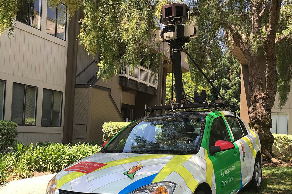
On May 25, 2007, Google released Google Street View, a new feature of Google Maps which provides 360° panoramic street-level views of various locations. On the date of release, the feature only included five cities in the US. It has since expanded to thousands of locations around the world. In July 2009, Google began mapping college campuses and surrounding paths and trails.
Street View garnered much controversy after its release because of privacy concerns about the uncensored nature of the panoramic photographs. Since then, Google has begun blurring faces and license plates through automated facial recognition.
In late 2014, Google launched Google Underwater Street View, including 2,300 kilometres (1,400 mi) of the Australian Great Barrier Reef in 3D. The images are taken by special cameras which turn 360 degrees and take shots every 3 seconds.
Google Latitude
Google Latitude was a feature from Google that lets users share their physical locations with other people. This service was based on Google Maps, specifically on mobile devices. There was an iGoogle widget for Desktops and Laptops as well. Some concerns were expressed about the privacy issues raised by the use of the service. On August 9, 2013, this service was discontinued, and in March 22, 2017, Google incorporated the features from Latitude into the Google Maps app.
Indoor Google Maps
In March 2011, indoor maps were added to Google Maps, giving users the ability to navigate themselves within buildings such as airports, museums, shopping malls, big-box stores, universities, transit stations, and other public spaces (including underground facilities). Google encourages owners of public facilities to submit floor plans of their buildings in order to add them to the service. Map users can view different floors of a building or subway station by clicking on a level selector that is displayed near any structures which are mapped on multiple levels.
Google Local Guides
Google Local Guides is a program launched by Google Maps to enable its users to contribute to Google Maps and provide them additional perks and benefits for the work. The program is partially a successor to Google Map Maker as features from the former program became integrated into the website and app.
The program consists of adding reviews, photos, basic information, videos and correcting information such as wheelchair accessibility.
Maps of areas other than Earth
Google has programs and features, including within Google Earth, allowing exploration of Mars, The Moon, the view of the sky from Earth and outer space, including the surfaces of various objects in the solar system.
Google took public domain imagery of the Moon, integrated it into the Google Maps interface, and created a tool called Google Moon. By default this tool, with a reduced set of features, also displays the points of landing of all Apollo spacecraft to land on the Moon. A collaborative project between NASA Ames Research Center and Google called the Planetary Content Project integrates and improves the data that is used for Google Moon.
Google Mars provides a visible imagery view, like Google Moon, as well as infrared imagery and shaded relief (elevation) of the planet Mars. Users can toggle between the elevation, visible, and infrared data, in the same manner as switching between map, satellite, and hybrid modes of Google Maps. In collaboration with NASA scientists at the Mars Space Flight Facility located at Arizona State University, Google has provided the public with data collected from two NASA Mars missions, Mars Global Surveyor and 2001 Mars Odyssey.
Mashups
Google Maps interface links through the “Wikipedia layer” to the geo-tags placed in English Wikipedia articles, but does not support non-English ones, reducing its usefulness in non-English languages and in non-English speaking territories. It also links to photos with GPS tags from Panoramio.
Isochrone maps can be generated using the Google Maps API.
Moon, Mars and starry sky
Since August 2014, the Moon and Mars can be explored via the Google Maps 3D interface. The two offers Google Moon and Google Mars in 2D are still available. Likewise, both celestial bodies can be explored in 3D by Google Earth since 2009. The starry sky is available in 2D view on Google Sky.
Programming interface
Google offers programming interfaces that allow you to integrate Google Maps into your own pages. Through API calls you can configure maps on your own pages, markers can be placed on maps. The Google Maps Platform’s 18 APIs include Maps, Routes, and Places.
The integration requires an API key that allows your pages to submit requests to Google Maps servers in the Google Cloud Platform. The standard and premium versions of Maps, available through 2018, have been combined so that an API call requires a payment profile – even using only the free quota. Each API call is chargeable, but Google grants a $ 200 credit per user per month for each month. Basic features such as embedding cards remain free, no matter how many times you use them. For this Google provides directly embeddable HTML code. The pixel dimensions of the representations can be defined in the code. As a result, you can use Google Maps to create larger maps than in the default view.
Different online mapping services
Baidu Maps, Bing Maps, Mappy, Here offer services similar to Google Maps. They have in common that access for certain uses is free, contain zoomable aerial views, and offer a route calculation service. Unlike the first cities, Mappy covers only Europe. OpenStreetMap also offers a global cartography, and a route calculation service, completely free and freely accessible for any use, it does not offer aerial views.
The cartography provided by the IGN on its Géoportail site is of the Matrix Image type. It is an old-fashioned cartography, which retains the notion of discrete scale (1/25 000, 1/100 000, etc.). The vector mapping that offers Google Maps provides a continuous scale with creating tiles on demand with a stylesheet type of CSS. The Geoportal site can also view additional layers, such as geological map of the BRGM.
Mobile versions
There are also several mobile versions of Google Maps, which use the phone networks including 3G to load the cards in the same way as on the Internet version. The versions vary a lot depending on the screen definition of mobile phones, having a touch screen, the power of the processor. Satellite positioning is implemented on most mobile devices carrying the required hardware. It is represented by a blue dot and an arrow if the positions were judged interpretable as a movement.
Features
Depending on the mobile navigation is by touch or with the keyboard. On the latest smartphone versions it is possible to choose between the three display modes: “plan”, “satellite”, and “mixed”; the last being a mixture between the first two. Since more recently is available the function ” Street View “To display photos, as for the Internet version, in some major cities. It is possible to create bookmarks on locations. A search function is also present. In addition to locating the desired location, it can eventually, for a company for example, display information such as its public telephone number, or its website. It is also possible to search and follow a route. Finally, a geolocation function is available on some versions, which uses, depending on the phone’s equipment, a GPS chip or a triangulation system using GSM antennas. The latter solution, however, is much less precise, especially in rural areas.
Popularity
With the availability to the public of a tool allowing it to visualize, by satellite photo, the whole world in a precise way, the project met a real success, so that sites exclusively dedicated to Google Maps were born. For example, the sites Google Sightseeing and Google Globetrotting are directories of direct links to monuments (Eiffel Tower, Statue of Liberty, etc.), known places or unusual places (house of Bill Gates for example), this in the world whole, using the Google Maps service.
A giant Monopoly was organized on Google Maps, the goal being to buy all available streets on Earth.
On April 1, 2010, Google pretended to have implemented 3D. To do this, a little guy on the left of the screen was wearing red and green glasses, clicking on it, a 3D printing was created. Of course, it was a hoax that stayed more than two days on the web.
The December 7, 2012, Google publishes an article on the Google Maps blog revealing that the service has more than a billion monthly users.
Copyright
The Google Maps terms and conditions state that usage of material from Google Maps is regulated by Google Terms of Service and some additional restrictions. Google has either purchased local map data from established companies, or has entered into lease agreements to use copyrighted map data. The owner of the copyright is listed at the bottom of zoomed maps. For example, street maps in Japan are leased from Zenrin. Street maps in China are leased from AutoNavi. Russian street maps are leased from Geocentre Consulting and Tele Atlas. Data for North Korea is sourced from the companion project Google Map Maker.
Errors
Fixing and reporting errors
In areas where Google Map Maker was available, for example, much of Asia, Africa, Latin America and Europe as well as the United States and Canada, anyone who logged into their Google account could directly improve the map by fixing incorrect driving directions, adding biking trails, or adding a missing building or road. General map errors in Australia, Austria, Belgium, Denmark, France, Liechtenstein, Netherlands, New Zealand, Norway, South Africa, Switzerland, and the United States could be reported using the Report a Problem link in Google Maps and would be updated by Google. For areas where Google used Tele Atlas data, map errors could be reported using Tele Atlas map insight.
If imagery was missing, outdated, misaligned, or generally incorrect, one could notify Google through their contact request form.
In November 2016, Google announced the discontinuation of Google Map Maker as of March 2017.
Maps data
In 2011, Google Maps mislabeled the entire length of US Route 30 from Astoria, Oregon to Atlantic City, New Jersey as being concurrent with Quebec Route 366.
Users are able to suggest corrections using the “Send feedback” button. These suggestions are reviewed, and either accepted or declined; the user is informed when this decision occurs.
Business listings
Google collates business listings from multiple on-line and off-line sources. To reduce duplication in the index, Google’s algorithm combines listings automatically based on address, phone number, or geocode, but sometimes information for separate businesses will be inadvertently merged with each other, resulting in listings inaccurately incorporating elements from multiple businesses.
Google allows business owners to verify their own business data, and has also recruited volunteers to check and correct ground truth data.
Google Maps can easily be manipulated by businesses which aren’t physically located in the area they record a listing. There are cases of people abusing Google Maps to overtake their competition where they place a number of unverified listings on online directory sites knowing the information will roll across to Google (duplicate sites). The people that update these listings do not use a registered business name. Keywords and location details are placed on their Google Maps business title which overtake credible business listings. In Australia in particular, genuine companies and businesses are noticing a trend of fake business listings in a variety of industries.
Imagery
Street map overlays, in some areas, may not match up precisely with the corresponding satellite images. The street data may be entirely erroneous, or simply out of date: “The biggest challenge is the currency of data, the authenticity of data,” said Google Earth representative Brian McClendon. As a result, in March 2008 Google added a feature to edit the locations of houses and businesses.
Restrictions have been placed on Google Maps through the apparent censoring of locations deemed potential security threats. In some cases the area of redaction is for specific buildings, but in other cases, such as Washington, D.C., the restriction is to use outdated imagery. These locations are fully listed on Satellite map images with missing or unclear data.
Source from Wikipedia