Escragnolles is a French commune located in the department of Alpes-Maritimes in the region Provence-Alpes-Côte d’Azur. Located in the hinterland of Grasse. Its twelve hamlets cover an area of 25.4 km² with an average altitude of 1000 meters.
History
The territory of Escragnolles has been inhabited since prehistoric times. Witness the many shelters under rocks, caves and other Celto-Ligurian camps that dot the land, not to mention the dolmens.
In the middle of the Middle Ages, the place was declared uninhabited, that is to say without a constituted community, just a few scattered settlements, following successive epidemics of plagues, devastation caused by armed bands, among others the troops of Raymond de Turenne, the “scourge of Provence”.
Raymond Requistoni (? -Av.1309) was Lord of Escragnolles. He joined forces with Cécile Cays, daughter of Bérenger Cays, co-lord of Peillon and Le Touët. The lord of Escragnolles, Raymond Requistoni, had during his lifetime a namesake who was knight and lord of the Val d’Ampus.
Following the plague of 1420, the population of the village was wiped out, and to repopulate it, it was necessary to appeal to inhabitants of the near region or the hinterland of Genoa, Figouns, large fig eaters and speaking figoun.
At the end of the 16th century, the Lord Henri de Grasse, with his daughter Françoise who owned land in Escragnolles, lacking the arms to make them fruitful, signed a contract with the community of Mons in order to bring in people who would create the hamlets and will restore the earth. A deed of residence was signed in 1562 and families came to settle. Currently, the names of the descendants of five of them still own the town.
Over the centuries, an agro-pastoral economy enabled the inhabitants to subsist, with difficulty because the land was poor and the climate harsh. The population, during the 20th century gradually decreased, but for about twenty years the curve has been reversed thanks to the arrival of more and more “rurbans”.
Hamlets
The very large commune is made up of 12 hamlets and the heritage is very diverse. The village and its hamlets try to keep their rural and mountain character, while projecting themselves into the future.
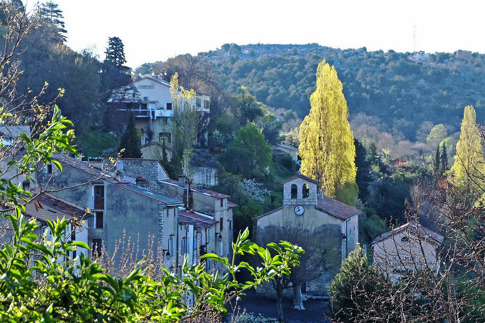
The Logis
(also called the Village) is the administrative center with the town hall, the post office and the church from the beginning of the 19th century where the busts of the two patron saints are located: Saint Pons and Saint Martin, as well as a magnificent Rosary table.
Les Amphons
6km from the village and whose name comes from the presence of a fountain. Seven houses in the fields. Oratory.
Lease
Also quite eccentric (7km by road, but 2km on foot by a nice little path), one of the first hamlets built in the 16th century.
La Bastide
4km away, where one of the last shepherds in the town lives.
Le Cabanon
4.5 km away, on the plateau where there are traces of an old Cetlto-Ligurian camp: Cogolin, directly above the Ray, the small river separating Escragnolles from Mons.
The Castle
5km, made up of the old castle of the 16th century of the family of the Counts of Escragnolles and transformed into apartments with, around, some recent small houses and the ruins of the Saint Clair chapel.
Clars
The furthest hamlet from the village (8km) near the source of the Ray.
La Colette
Hamlet which in the 16th century consisted of 2 houses and where a housing estate was built in 1970. Nearby, in the woods, there is a dolmen of which there is no longer the cover slab.
Les Galants
4km, whose name could come from a family name: Bastide des Gallans in 1733. About 1 km away on foot is the waterfall, called the Galants or the Ray (lou pissaïré).
Les Gras
5.5km, named after the first founding families of the hamlet. This hamlet is the southernmost inhabited hamlet of the village and the lowest, right up against a rocky ridge.
Les Mourlans
4.5 km by road, named after the 2 founding families of the hamlet. Descendants still live there.
Saint Pons
Just at the foot of the village (barely 500 meters) also created in 1562, with the Saint Pons chapel transformed into a meeting room. The new school was built there in 2001.
Historical heritage
Fortified habitats, enclosures, oppidum, castellaras. The fortified points are very numerous, always in sight of each other around a larger and better defended fortified habitat.
Religious heritage
The Saint-Martin church. Built in the xvi th century and rebuilt in the xviii th century.
The Saint-Pons church. Wrongly called Saint-Ponschapel.
The cemetery chapel. Small chapel in the cemetery.
The Saint-Martin chapel. Numerous fossils on site.
Other heritage
The recently restored Saint Martin chapel, where some frescoes remain, on the old path from Grasse to Castellane.
The Napoleon path where the emperor would have passed on his return from Elba Island.
The Claps dolmen.
The ruined hamlets of Rouyères and Gabre.
The Briasq plateau from where the view extends to the Lérins Islands and where 2 very old oak trees still remain
(the others were used during the last war to make gasifier).
The Parra waterfall, very beautiful but dangerous access.
The “megalithic” camps of Castellas, Conrouan,….
Events
Annual donkey festival. The Donkey Festival takes place every year on the last Sunday of June
Natural heritage
Hydrography and groundwater
Stream in the town or downstream:
The Siagne, or Grande Siagne, originates in the Audibergue, its initial course is most often dry. It takes all its power after the Vaucluse source of the Garbo.
The Siagne de la Pare or Escragnolles has its source there. On the map of the eastern borders (1776), its initial course was called the river of ‘black waters’. The exsurgence (Vaucluse source) of La Pare was bought for 20,000 gold francs by the Syndicat intercommunal des Cinq-Communes. With the exsurgence of the Garbo, it drains the karst of the Audibergue.
It joins the Siagne after a very steep course which is a delight for canyoning enthusiasts.
Siagne de pare,
Vallons of nans, glue, st-martin, la combe, mourlans, la combe d’andon, ray.
The Belletrud canal (1931) has its catch in the Pare cave. To get to Saint-Cézaire-sur-Siagne, it overlooks the valleys of the Siagne d’Escragnolles then the Grande Siagne, which it spans over the Bois des Malines, crosses the Siagne canal before starting a long passage underground to reappear at the Mauvans bend.
It is possible but dangerous to hike along this canal, sometimes taking the obstacle-crossing tunnels of the canal (which were dug without motorized devices, by hand and with explosives!). This canal supplies the municipalities of Saint-Cézaire-sur-Siagne, Le Tignet, Spéracèdes, Cabris and Peymeinade.
Escragnolles has two purification stations: Escragnolles-chief town, with a capacity of 500 inhabitants equivalent. Escragnolles-Le château, with a capacity of 250 Inhabitants equivalent
Agriculture
The figouns farm.
The educational farm “Apiary Abelha”.
Farmer, activity sector of the cultivation of vegetables, melons, roots and tubers
Aïd-el-Kébir, farm slaughterhouse.