Cap d’Ailis a French commune located in the department of Alpes-Maritimes in the region Provence-Alpes-Côte d’Azur, in the western limit of Monaco. Its inhabitants are called the Cape d’Aillois. The town takes its name from the eponymous cape (Cap d’Ail), located on its territory.
Cap d’Ail, until 1860, was attached to the County of Nice. It was in 1908 that Cap d’Ail, which depended on La Turbie, became a town in its own right.
The territory of the municipality was included in the municipality of Turbia, and therefore in the past it was considered the western limit of the Italian geographical region. It borders on the Principality of Monaco.
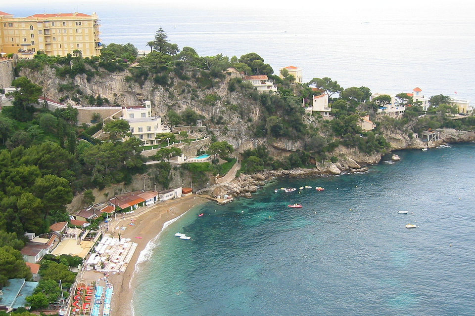
Cap-d’Ail has beaches reputed for their natural beauty, and also a coastal path, which runs alongside a typical Mediterranean vegetation. The embankment of the coast, characteristic of the Monegasque water catchment area, plunges the municipality from the vertical slopes of the Tête de Chien to the wild coves of the Mala beaches.
Geology
Cap-d’Ail has beaches known for their naturalness, as well as a coastal path, bordered by typical Mediterranean vegetation. The steep relief, characteristic of the Monegasque watershed, plunges the town from the vertical slopes of the Dog Head to the wild coves of the beaches of the Mala.
Climate
The climate of the Alpes-Maritimes is very varied despite its relatively small area. In the south there is a Mediterranean climate, in the north a mountain climate and towards Cannes a particularly hot micro-climate due to the high hills warming the air which descends on the city.
The coastal strip experiences very mild temperatures in winter and hot but not excessive in summer, despite episodes of extreme heat. The “rainy season” takes place in autumn and spring, particularly in April and September, in particular due to fairly frequent thunderstorms. Summer is known for its drought. Sunshine is very important, there are almost 300 days of good weather per year. However, the temperature differences due to a warm sea in autumn are the source of severe thunderstorms, often with floods and floods.
As soon as one moves away from the coast, towards the west of the department, the interior plains (notably on the Grasse side) experience a slightly less temperate but equally sunny climate. In summer the temperature very easily exceeds 30 ° C, while the average is “only” 27 ° C on the seaside of Nice for July and August. Conversely, small frosts are not excluded in winter when they are very rare in Nice.
To the east of the department, unlike the west, there are no plains. In the region of Menton the altitude increases very quickly towards the interior of the land, the sea therefore tempers the atmosphere much more: the maximums in summer are on average 25 ° C and the winters are milder than in the interior Where is. Jellies are almost excluded.
The snow is rare on the coast, however, sometimes good falls surprise the French Riviera, as was the case in winter 2004-2005 when the city of Nice woke up with a few centimeters of snow in a road mess. More recently, infebruary 2010, we measured more than 10 cm of snow in Cannes and almost 30 cm in the Grasse region.
Ports
The artificial port of Cap-d’Ail, at the eastern end of the municipality’s territory, has its northeast quay bordering Monaco, at Fontvieille, like the entire eastern part of the municipality.
Port Hercule (Port of Monaco),
Port Lympia (port of Nice).
The Cap d’Ail marina is located in the WESTERN part of the Rock of Monaco. The EASTERN side of the marina is bounded by the French-Monaco border.
Distances: BEAULIEU sur Mer 4 NM – CALVI 95NM
Seamarks: Tête de Chien mount in the NW – Cap Ferrat lighthouse 5NM away – Rock of Monaco less than 1NM in the NE.
Approach by day: entrance channel at 090°, after passing the end of the breakwater dyke.
Accès: Both day and night time, in all weather conditions. When the wind is fresh, strong surf along the Digue du Large, sail at 0.5NM. Watch out, when the WESTERLY wind is strong, swell and surf in the harbour basin.
Surroundings
Under the watchful « Tête de Chien » promontory, which overhangs the Principality of Monaco and the township of Cap d’Ail, the marina provides boaters and users a haven of peace and tranquillity. Located along the Monaco’s border, the small recreational fishing boats are moored next to big pleasure yachts at the 260 berths of the marina. The marina is an ideal starting point to visit Monaco, get to the Marquet beach or the Mala beach, strolling along the coastal trail and the Pointe des Douaniers.
An interpretation trail, about four kilometers long, goes around the cape from Mala beach to Marquet beach: its route allows you to discover the Mediterranean flora through explanatory panels, an unusual quarry of millstones with traces of excavation carved into the rocks of the shore, the luxuriance of exotic gardens and villas with Belle Époque architecture: the Perle blanche villa of the Lumière brothers, the Château Malet and its botanical park, the Château des Terrasses, the Roc Fleuri villa (one of the specificities of its botanical park resides in the presence of a nonagenarian palm grove of Phoenix canariensis whose introduction on the Côte d’Azur dates back to the years 1864), the villa Les Funambules and the Parc Sacha Guitry, are the few witnesses of this architecture and the movement of acclimatization engaged in xix th century. Preventive signage advises against its access in the event of a sea blow.
French Riviera
The French Riviera is the Mediterranean coastline of the southeast corner of France. There is no official boundary, but it is usually considered to extend from Cassis, Toulon or Saint-Tropez on the west to Menton at the France–Italy border in the east, where the Italian Riviera joins. The coast is entirely within the Provence-Alpes-Côte d’Azur region of France. The Principality of Monaco is a semi-enclave within the region, surrounded on three sides by France and fronting the Mediterranean. Riviera is an Italian word that corresponds to the ancient Ligurian territory, wedged between the Var and Magra rivers.
The climate of the Côte d’Azur is temperate Mediterranean with mountain influences on the northern parts of the departments of Var and Alpes-Maritimes. It is characterized by dry summers and mild winters which help reduce the likelihood of freezing. The Côte d’Azur enjoys significant sunshine in mainland France for 300 days a year.
This coastline was one of the first modern resort areas. It began as a winter health resort for the British upper class at the end of the 18th century. With the arrival of the railway in the mid-19th century, it became the playground and vacation spot of British, Russian, and other aristocrats, such as Queen Victoria, Tsar Alexander II and King Edward VII, when he was Prince of Wales. In the summer, it also played home to many members of the Rothschild family. In the first half of the 20th century, it was frequented by artists and writers, including Pablo Picasso, Henri Matisse, Francis Bacon, Edith Wharton, Somerset Maugham and Aldous Huxley, as well as wealthy Americans and Europeans. After World War II, it became a popular tourist destination and convention site. Many celebrities, such as Elton John and Brigitte Bardot, have homes in the region.
The eastern part (maralpine) of the Côte d’Azur has been largely transformed by the concreting of the coast linked to the tourist development of foreigners from North Europe and the French,. The Var part is better preserved from urbanization with the exception of the agglomeration of Fréjus-Saint-Raphaël affected by the demographic growth of the maralpin coast and the agglomeration of Toulon which has been marked by urban sprawl on its part West and by a spread of industrial and commercial areas (Grand Var).