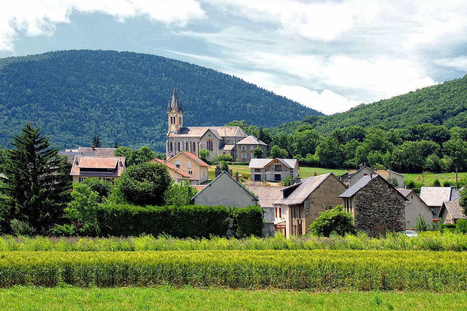
Pierre-Châtel is a French commune located in the department of Isère, in the Auvergne-Rhône-Alpes region. Pierre-Châtel is crossed by the famous Route Napoléon, which was taken by Napoleon on his return from Ile D’Elba. The local features are ski resorts of Alpe du Grand Serre and its gastronomic specialties rich in tradition and authenticity.
The town of Pierre-Chatel is located on the Matheysine plateau, between Laffrey (north) and La Mure (south) and between La Motte-d’Aveillans (west) and Saint-Honoré (east).
Petichet, Laffrey and Lac Mort which give an additional identity to the mid-mountain landscapes (the summit of the Obiou even borders the 3000 m). Rock and water are two inseparable elements of the region, bordered by the Drac and the dams that line it, the Vercors and Trièves mountains, the Grand Serre (2146m) and Tabor (2390m) massifs.
The population of Pierre-Châtel is estimated at around 1500 inhabitants spread over the various hamlets of the town. The characterizes of the town is the fact of being cut by a large rocky bar which divides its surface and the number of inhabitants apart roughly equal, but hinders communication between them. As a result, some of our equipment is thus doubled (school groups, village hall)
History
This town is on the route of the Napoleon road. In 1789, Pierre-Châtel belongs to the Kingdom of France. In 1793, The department of Isère is created. The town is called Pierre Chatel, is part of the canton of Saint Théoffrey, in the district of Grenoble. In 1801, Pierre Chatel becomes Pierre-Châtel, in the canton of La Mure, in the district of Grenoble.
The town of Pierre-Châtel is part of the canton of La Mure, in the arrondissement of Grenoble, in the department of Isère and in the Auvergne-Rhône-Alpes region.
Surrounding villages
La Festinière (in the west):
Located at an altitude of 970 m, it owes the growth of its population to the contribution of the mining town “Cité Cordier” created in the 1960s. In the past there was a narrow railway line which joined the Peychagnard which allowed the coal to be brought to the quay to sell it in the warehouses at a place called “the station”.
Puteville (in the west):
Located at an altitude of 1010 meters, this lively little town was also called a “small town”. Located in the Creys hill dominated by Pierre-Percée. In the south-eastern part of the village a charming chapel which belongs to the Beillonjourdan family (it is this same family who ceded their land for the construction of the chapel of the Festinière today transformed into an association room and school restaurant).
Le Collet (in the south-west):
It is located below the Festinière. It is characterized by the railway track of the little train of Mure which crosses it in its middle which makes the inhabitants say that they are from Collet d’en bas or Collet d’en haut. The Saint Jean Baptiste chapel which is the property of the municipality, dating from 1784. It was completely restored by the inhabitants in 1959. A few meters from this chapel there was a 15th century castle, of which only an underground remains today. hui, it is good to point out that the longest tunnel of the Mure railway leads to Collet. In the southern part of the hamlet there are wetlands and marshes linked to a fish pond “pond of Crey” in the town of Susville.
Lespinasse (in the north):
Located on the hillside of the Creys at an altitude of 966 meters, this hamlet overlooks the lake of Pierre-Châtel. Very close to the Napoleon road, it is the most northerly of our town. In the past, there was a coal mining operation “the Picardon mines”. This coal was evacuated by wagons via the Charvet route as far as Collet. Later, an important dairy saw the light of day until the 1990s when it closed, since these buildings house several small businesses and artisans.
Feyteny (in the west):
Located at an altitude of 949 meters, leaning against the hillside of the Rivoire, there was at the time a church very close to the two current cemeteries, Chemin de La Pierre-Percée passing by Ventafo, in front of it a municipal school with meadows of one hundred pupils held by sisters.
Ser-Sigaud (in the south-east):
It is nestled near the slopes of the Serres between the Route Napoléon and the old Roman road. St Barthélémy chapel, built around 1580, owned by the inhabitants of Ser-Sigaud.
Les Bruneaux (in the east):
Located at 945 m altitude. It was inhabited by a famous Arribert – Desjardin family, many of whom were mayors of Pierre-châtel.
Pérouzat (in the south-east):
Located at an altitude of 959 meters, it is one kilometer from Pierre-Châtel and very close to the Roman road.
Le Mas-Briançon (in the south-west):
Located at an altitude of 906 meters between the Route Napoléon and the departmental 529, it is the closest to the wetlands. This hamlet housed an illustrious family “The Germans of Montrigaud” with a large residence which has now disappeared.
Agriculture
Pierre-Chatel have nine farms, six of which are run by farmers with an outside activity due to the small size of their farm. In our system of breeding and mixed farming, the farmer nevertheless plays an essential role in the maintenance of natural spaces: mountain pastures, crops, meadows, size of hedges, sustainability of rural roads. The farmer enlivens the landscape.
Harvest festival
This weekend of August 10 and 11 was marked by the Harvest Festival. In Saturday evening, a farmers’ market delighted traders and visitors. on Sunday, many activities punctuated the day: Mass under a marquee, mowing, threshing with a steam engine, demonstrations of the trades of yesteryear, agricultural equipment, farm animals, dances traditional, making village associations, games for children and entertainment.
Industrial heritage
The remains of the three mine shafts (Putteville mine) are still visible
The markets of Pierre-Châtel
Our market has been firmly established for several years and takes place in summer and winter every Sunday morning, under the Market Hall or on the Town Hall Square depending on the festivities, in a very friendly atmosphere.
Sunday market
Every Sunday morning, the inhabitants of Pierre-Châtel and the surrounding area mingle with tourists to discover, through the colorful stands, seasonal and local quality products. On the gourmet side, sausages, meats, cheeses, honey, various fruits and vegetables; artisan side, fashion items and decorative items. Not to mention a wide choice of flowers that will bring joy to balconies and gardens!
Christmas market
Each year, many exhibitors and artisans come to offer their products, all from regional production and artisanal manufacture (cold cuts, foie gras, meats, poultry, cheeses, pastries, jams, jewelry and decorative items)…. What good things to prepare your Christmas meal. A living nativity scene, with real animals is set up for the day to amaze young and old.
Natural heritage
La Pierre Percée, a rock with holes that is one of the Seven Wonders of Dauphiné.
The lake of Pierre-Chatel.
The Col de la Festinière (964 m).
La Pierre-Percée:
one of the seven wonders of Dauphiné, this geological curiosity of glacial-lacustrine origin is located at 1,220 meters altitude, on the Creys hill, on the edge of the town of Pierre-Châtel. This flap of Triassic cargneule, composed of silica and dolomite, was slowly hollowed out by chemical dissolution of the limestone, originally associated with these elements in the original rock. From the north, at a long distance, the eye thinks it sees the silhouette of a huge dragon biting its tail. Up close, the appearance remains surprising. The opening is 5.50 m: the vault is 3 m high: the west pillar has a circumference of 26.30 m and curves in an arch to n ‘. From the belvedere, we discover a splendid and striking panorama of the Matheysine, its mountains and its lakes.
The lake of Pierre-Châtel
The lake of Pierre-Châtel which is located north of the town at an altitude of 930m. It has a maximum depth of 11m and an area of 140ha. This still very natural (wild) lake of character has a landscaped communal beach for swimming, picnics and family walks. It is private and belongs as well as its castle to the DE MARLIAVE family