L ‘ Oisans is a region of the French Alps located in the departments of Isère and Hautes-Alpes, corresponding to most of the watershed of the Romanche river and its tributaries. It thus has six main valleys of which Le Bourg-d’Oisans is approximately the center. Oisans, mostly rural, is located in a busy plain until the turn between the XVII and XVIII century by aglacial lake which separates the Upper from the Lower Romanche. This location, on the road to the Italian peninsula, therefore makes access to Oisans strategic since Antiquity. The Romans dominate the people of Ucènes and arrange the trade route. Mining began at this time and resurfaced periodically until the 19th century. The town of Livet-et-Gavet, became an industrial center in the XX century with the development of hydroelectric power that enabled the development of many industries into the 1970s.
Much of the economy of Oisans is based on tourism. Four ski areas share the massifs. Among the main resorts are Alpe d’Huez and Les Deux Alpes. They diversify their activities by offering summer sports. Some museums help to unveil the history and wealth of the region. In addition, hiking and mountaineering allow you to discover the most preserved parts of Oisans, protected in particular within the Ecrins National Park, Natura 2000 sites and several classified sites. Indeed, due to itsAltitudinal staging and its variations in exposure to the sun, the region is home to an important diversity of ecosystems.
A true paradise for lovers of wide open spaces, “soft” or strong sensations and striking landscapes, this corner of the French Alps is located between the departments of Isère, Hautes-Alpes and Savoy. Mountain ranges with peaks reaching between 3,000 and 4,000 meters surround the Oisans. The most emblematic is the Meije, at 3,983 meters above sea level. The eastern end of the Haute Romanche, the Col du Lautaret, at an altitude of 2,058 meters, is twenty kilometers from the Italian border and the Po plain. The geographical location of Oisans, on the border of the northern Alps and the southern Alps, is a climatic opportunity. You will find a beautiful sun a large part of the year, 300 on average for the altitude resorts like “the island in the sun” (Alpe d’Huez).
Geography
Oisans is located in the Southeast of France, straddling the southeastern end department l ‘ Isere in region Auvergne-Rhône-Alpes and the extreme northwest of the department of Hautes-Alpes in Provence-Alpes-Côte d’Azur. It lies between Grenoble and Briançon, about 150 kilometers south-east of Lyon. It is part of the Alps chain. The Italian border is twenty kilometers from the eastern end of the Oisans.
Topography
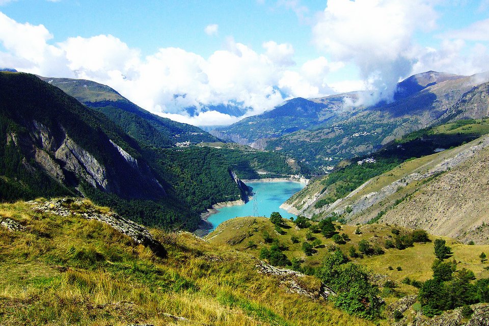
Oisans geographically corresponds to the Romanche watershed upstream of Séchilienne. The source of the latter is at the foot of the Plate des Agneaux glacier under the Chamoissière peak, west of the Lautaret pass. This definition earned it the formula of “Oisans with six valleys”: its main tributaries are, on the right bank, the Ferrand downstream of the lake of Chambon, the Sarenne at the level of Bourg-d’Oisans and the Eau d’Olle. which crosses Allemond, as well as on the left bankVénéon downstream from the Infernet gorges and Lignarre downstream from Bourg-d’Oisans. However, historically, the mountain pastures located south of the Col du Glandon and the Col de la Croix-de-Fer to the Grand’Maison lake belong to the Maurienne province of the former Duchy of Savoy and are therefore excluded from Oisans; Similarly, the territory of the commune of Chantelouve, in Valbonnais, extends north of the Col d’Ornon.
Oisans thus covers part of the Belledonne massifs – which separates it from the Grésivaudan basin -, Grandes Rousses and Arves in the north, Taillefer in the southwest and Ecrins in the south and east. The highest point in the region is the Lory peak, an antecime of the Barre des Ecrins which culminates at an altitude of 4,088 meters, at the bottom of the Vénéon valley, on the border with Vallouise in the Briançonnais. However, the most iconic summit isthe Meije, culminating at an altitude of 3,983 meters entirely between the valleys of Haute Romanche and Vénéon, and nicknamed the “queen of Oisans”. South of Oisans are the basins of Valjouffrey and Valgaudemar.
The departmental road 1091, former RN 91, connecting Vizille to Briançon is the main access road to this territory.
Geology
Oisans is located in the heart of several crystalline massifs of the outer Alps. These constitute blocks of the ancient metamorphic Hercynian base (gneiss, mica schist, migmatite) which tipped over during the Jurassic during the rifting that gave rise to the Tethys. They are separated by hemigrabens where the valleys nest. The old erosion surface of the Hercynian range is still found in the form of peneplains, for example at the Emparis plateau, at the Mont-de-Lans glacier, at Chamrousse or at the Grand Galbert. In this relatively deep sea, limestones from Lias form, which can be found in particular in Bourg-d’Oisans, Mizoën, La Grave and Villar-d’Arêne.
In the Lower Cretaceous, the sea becomes shallower but the Oisans is on its margin and the Urgonian is not very present. In the Upper Cretaceous, theAlpine tethys closes and a subduction takes place. It ends in the Eocene while the beginning of uplift in the Alps is accompanied by erosion which contributes to the formation of sandstone. In the Oligocene, the continental collision causes the overlap and the fracturing of the blocks while the sedimentary rocks to pucker, leading to the current general structure of Oisans.
In addition, the coal from the decomposition of ferns of the carboniferous is present in several places of the Oisan. Of granites from plutons of the Permian are prevalent in several areas, including Rochail, in the valley of Lanchâtra east of the rock Muzelle around La Bérarde and peaks Combeynot. They are the result of crustal thinning. They are accompanied by training, by hydrothermalismOf vein minerals of copper, iron, lead, zinc, silver, gold, etc. Of dolomite born of sedimentation in shallow ocean Trias is also interposed between the lens base and limestone; it contains traces of evaporite. It is locally topped by layers of spilite deposited following episodes of submarine volcanism announcing the opening of the Jurassic rift.
In the Pleistocene, Oisans was occupied by several glaciers. That of Haute Romanche peaks at the maximum of the Mindel glaciation at an altitude of 2,600 meters in the vicinity of the Lautaret pass; it reaches approximately 2,250 meters at Chambon. Its junction with that of Vénéon then reached a level of 2100 meters at the Bourg-d’Oisans and then up to a hundred meters because of the confluence with the glacier of the Eau d’Olle to lock Rochetaillée. The thickness of the Rissian glacier is less. This lock is therefore responsible for the glacial umbilicus of Bourg-d’Oisans and the appearance of a lake after the last glaciation. The glacier is then evacuated by the Basse Romanche, and possibly by diffluences on the left bank, towards the glacier of Isère. The lake is gradually filled until the second half of the II millennium.
Attractions in the area
Emparis plateau
The Lérié Lake and Black Lake, nestled on the Emparis plateau, are beautiful lookouts facing the edges of the north face of the Meije and Rake (3809 m). It crosses along the GR54, from Besse-en-Oisans to Chazelet. Classified Natura 2000, the plateau offers fabulous landscapes: flowery meadows as far as the eye can see in spring, with La Meije and its Glaciers as a backdrop, all at an altitude of around 2000 m. An ocean of greenery, calm and relaxing, in the heart of the steep reliefs of Oisans.
The largest global network for the preservation of biodiversity.The biological richness of the Emparis plateau is exceptional. Indeed, its location at the intersection of two biogeographic areas (internal Alps, intermediate Alps), but also at the climatic limit (Northern Alps and Southern Alps), as well as its great geological variability and its contrasting geomorphology, create conditions very varied ecological systems, favorable to the development of numerous plant and animal species. The landscape is strongly linked to agro-pastoral activities. The hay meadows, of great biological richness, surround the hamlets. Above about 2,200 m, you enter the mountain pastures, the domain of herds of cattle and sheep. There are remarkable wetlands, especially in the valley of Goléon and on the Plateau d’Emparis.
Many geographical and geological criteria but also linked to human activity such as pastoralism are at the origin of these steppe landscapes. The herds, which always go up in the pastures, participate in the charm of the place. The history of pastoralism can be visited at the Maison des Alpages in Besse-en-Oisans. Particularity of this site, within a mineral Oisans, water is present in abundance: peat bogs, lakes, torrents … And even petrifying fountains, the only ones in Oisans, going down towards the Clots refuge. Hikers, herds, shepherds, protection dogs, guardians of refuges and wildlife: even if the places are very large, life in the pastures is rich.
Lauvitel lake
At an altitude of 1530 m, this emerald mirror set with green peaks is one of the most beautiful sites in Oisans. The valley of Lauvitel leads to the lake of the same name: a jewel set with steep and rocky slopes descending from the peaks of Rochail (3022 m), the head of the Muraillette (3019 m) and the signal of Lauvitel (2901 m). Contrary to appearances, it is located in the town of Bourg d’Oisans. Due to its depth (68 m), its surface area (37.2 hectares) and its water volume (6.8 million m 3), the Lauvitel is the biggest lake in Oisans.
The formation of the natural water reservoir and occurred about 4000 years ago. It is due to a rock slide which has been added to a glacial moraine already existing at the bottom of the valley. A pile of fragmented blocks bears witness to an ancient cataclysm that barred the valley. Above the lake, the landslide plane also testifies to this. During the winter, the ice sheet is more than a meter thick. When the snow melts, the excess water from the surrounding peaks exceeds the flow capacity by porosity and the lake can rise 20 meters from its lowest level in the summer.
Its lake banks adjoin the Lauvitel integral reserve, which is closed to the public. Created in 1955 for “enhanced protection of flora and fauna for scientific purposes”, it is the first space of its kind to have been created in a French National Park. Its purpose is “to monitor the natural dynamics of ecosystems”. For a long time the only integral reserve in a French National Park, it has become the benchmark in this field in France.
La Meije
La Meije is made up of three main summits: the highest point, the Grand pic de la Meije at 3,983 meters (2 nd major summit of the Ecrins after the Barre des Ecrins which rises to 4,102 meters), the Doigt de Dieu or Pic Central de la Meije (3,973 meters) overlooking the southern slope and the eastern Meije (3,891 meters), large snowy shoulder. Between 1870 and 1877, all the great summits of the Alps were climbed. All except one: La Meije. This citadel of ice and granite was to oppose, even more than the Matterhorn, a fierce resistance to the efforts of the climber… It occupies a special place: it was the last major summit in the Alps to be climbed after many attempts.
The south face of the Meije is also the site of many rocky routes for climbing enthusiasts. The ascent is generally made by the southern ridge of the Promontory and is linked with the crossing of the ridges to the finger of God. Following the collapse on May 15, 1964 of the Zsigmondy breach, which then lowered by 20 m, the route became more difficult, and the bypass of the first tooth (Zsigmondy tooth) was equipped in 1971 with cables metal to facilitate and secure the passage.
Crossing the Meije is a great race, requiring a certain ease in all areas of the high mountains: rock, snow and ice, but at a still reasonable level of difficulty. You also need to be in good physical shape and not fear the emptiness that grows with each step. La Meije is a prime objective for mountaineers with multiple routes in very varied styles. But the mountain is “alive”, the routes therefore change depending on the terrain that moves. Local guides follow the mood and are the only keepers of “up to date” information.
Le Pic Blanc
Culminating at an altitude of 3,330 m in the heart of the Grandes Rousses massif, the Pic Blanc offers a panorama as far as the eye can see over an ocean of peaks. Pic Blanc offers a wide and breathtaking panorama from the main terrace: Pic Bayle, Grande Casse de Pralognan, Grande Motte de Tignes, Grand Paradis in Italy, the Vanoise glaciers, the Dent Parrachée, the peaks of the Maurienne as well as the Meije, the Barre des Ecrins and the Mont-de-Lans glacier. Straddling the municipalities of Oz-en-Oisans and Freney, the Pic Blanc is the 3 rd summit of the Massif des Grandes Rousses after Pic Bayle (3465 m) and the Peak of the Standard (3 464 m). The highest point of the Alpe d’Huez Grand Domaine Ski, it has been a major asset since the construction of the cable car in 1963.
With an average of 300 days of sunshine per year (according to Météo France), Alpe d’Huez is nicknamed “the island in the sun” and the view from the Pic Blanc is very often clear. It is therefore not surprising that thousands of people go up there in summer and winter. In summer, a myriad of colors seems to have come out of a painter’s palette: the blue of the sky, the white of eternal snow, the green of the mountain pastures, the ocher of the rocks, the emerald green of the most beautiful lakes … The contemplatives may be able to observe the flight of a griffon vulture or a chough. Experienced athletes will descend the Pic Blanc as do the participants of the Megavalanche, a famous mountain bike race. When winter whitens the summits, the Pic Blanc is the start of 2 legendary slopes: Sarenne, one of the longest slopes in the world and Le Tunnel, whose impressive slope begins at the exit of a tunnel reserved for skiers.
La Bérarde
Heart of the Ecrins, where the spirit of the place still resonates with the great names of mountaineering, it is a space of freedom and meeting for all mountain lovers. Hamlet of St-Christophe-en-Oisans, La Bérarde marks the end of the road. At the bottom of the Vénéon valley, it is the last place of residence before the refuges and the high mountains…
The meeting of the Etançons torrent and the Vénéon has shaped a valley floor conducive to the establishment of a village. Surrounded by high peaks (3,000 to 4,000 m) long remained indomitable, La Bérarde is the starting point for the most beautiful races in the Ecrins massif such as Meije or Les Bans. What made this small village the Mecca of Mountaineering. Today, it is only awakened in winter by ski hikers or the bravest locals who come here on foot, snowshoes or skis. But it remains inhabited by many Bérardins from spring to autumn.
Ecrins National Park
It is a generally vast territory of which the biological richness, the landscape quality, the cultural interest and the historically preserved character justify a protection and a management which guarantee the sustainability of this heritage considered as exceptional. Oisans is a land of high peaks, deep valleys, glaciers and landscapes of wild beauty. All this gives the national park its character and its status as a European high mountain park. The Vénéon valley is the deepest in the park, it leads mountain dwellers and visitors to the heart of the massif, taking the pioneer routes of the Gaspards, Turks and Rodiers, which symbolize mountaineering and the openness of Oisans to discovery tourism.
It is a high mountain territory with a complex architecture. Summits, ridges, walls, large north faces draped in ice, arid scree, mountain pastures with clear lawns, lakes, torrents, waterfalls, refuges, pastoral huts, a tenuous network of paths constantly challenged, tirelessly maintained. And it is these trails that allow the discovery of unspoiled nature whose rich flora and fauna arouses interest. School of humility, the heart of the Ecrins National Park is above all the bearer of the intangible values that form the basis of human relationships with preserved nature and large landscapes.
Col du Glandon and Col de Croix de Fer
The Col du Glandon (1,924 m) and that of the Croix de Fer (2,064 m), 2 km apart, form the junction between Isère and Savoie, between Oisans and Maurienne. From the Col du Glandon the view of the Col de la Madeleine and Mont Blanc is magnificent. From the Col de la Croix de fer, at the foot of the Pic de l’Etendard (3,664 m) and its glacier, you will have a breathtaking view of the Arvan valley, the Aiguilles d’Arves and the summits of Massif des Sept Laux.
21 Legendary Turns
High place of the Tour de France, Alpe d’Huez and its 21 bends are among the essential stages of the passage of the Grande Boucle. 21 panels punctuate the runner’s effort in a countdown of 14 km over 1120 m of vertical drop. This begins to attract travelers, mainly in summer: the newly built main communication path allows easy access on sunny days. The huizat Joseph Collomb, provides a small transport service for people and goods between the valley and the village of Huez. 2h30 is then enough to make the journey by horse-drawn carriage.
In 1964, the president of the Alpe d’Huez Sports Club, Georges Rajon climbed the 53 numbered bends of the Vršič pass, in Slovenia. He immediately decided to export the concept to Oisans, in order to “take out the curves leading to Alpe” and “indicate to tourists the approach to the resort”. It was on the occasion of the 1968 Grenoble Olympic Winter Games, another strategic event in the development of the climb to Alpe d’Huez, that 21 numbered panels were created. They are modeled on those of the historical monuments of the time, and located at each turn of the climb. Little by little, the old names of uses are replaced by these 21 numbers in the collective memory, to the point of constituting today one of the markers of the identity of the station.
Autaret and Galibier pass
A strategic passage on one of the rare roads which crosses the Alps… The Lautaret and the Galibier are names which resonate in a “mythical” way by the high mountain atmosphere and the landscapes crossed on both sides of the passes. The Col du Lautaret, 2058 m, is the highest French pass open to road traffic all year round. It is the crossing point between Oisans and Briançonnais, and the border separating the Northern Alps from the Southern Alps, between the Ecrins and Arves massifs. The Galibier pass, 2,642m, straddles Savoie to the north and the Hautes-Alpes to the south. It connects the Grave and Briançon, via the Col du Lautaret, to Valloire then St-Michel-de-Maurienne via the Col du Télégraphe. 5 th highest pass in the French Alps, it is closed in winter.
Superb views can be admired from the Lautaret pass the link of the Meije southeast, that of the Grand Galibier north, and several summits of the Ecrins. A little higher from the Galibier, the view is breathtaking over La Meije (3,982 m), the Guisane valley and the high peaks such as the Barre des Ecrins (4,102 m), the Pelvoux (3,946 m) and even Mont Blanc (4810 m) in good weather.
Ice Caves
Buried in the bowels of the Girose glacier since 1995… First cave dug in Oisans, anchored in the ice, more than 30 m below the surface of the glacier, a wonderful world awaits you. Big construction to be able to open the cave every summer… It goes down 24 m per year. The galleries close, the sculptures are deformed and the cave has a tendency to tip over. Working with nature requires adapting. Enjoy this spectacle while there is still time.
Ecosystem
Oisans is home to a wide variety of ecosystems. The adrets, like those of Romanche and Combe de Malaval, are generally dry and sunny. They present pioneer lawns on rock to Houseleeks and stonecrops, grassland and dry grasslands, heath and shrublands xerophilic to juniper, associations talus and siliceous escarpments and sometimes locally limestone and xerothermophilous.
The ubac is home to larch woods at the bottom of the slopes, alder groves in the avalanche corridors and slopes, subalpine heathland with cranberries, cold heathland with crowberry, rhodora groves with ferruginous Rhododendron, thickets of willow shrub arctic-alpine, the tall-herb, subalpine meadows and alpine meadows, snow valleys formations dwarf willow, pioneer lawns slabs of rock and debris, plant associations of moraines and screeor rock faces.
The cold edges of the torrents have woodlands of white alder and ash tree grown in gallery. Wetlands are also found at altitude around the lakes, peat bogs and marshes of the Taillefer massif.
The tray Emparis has a variety of vegetation types: subalpine meadows Fescue mustard, pastures in Nard steep, alpine lawns evergreen sedge, Seslérie Blue and Fescue violet, the valley formations Snow willow dwarf, subalpine ericaceous moors, cold heathlands of altitude, rock gardens with pioneer formations, limestone and siliceous scree, rocky escarpments and saxicolous associations and wetlands cover the plateau.
The subalpine floor sparsely houses the Swiss pine and the hook pine. Only lichens colonize the highest peaks.
Flora
Many regulated species of flowering plants have been identified in the various natural areas of ecological, faunistic and floristic interest (ZNIEFF): the split dolphin (Delphinium fissum), the yellow gage (Gagea lutea), the Cornish Physosperm (Physospermum cornubiense), Alpine columbine (Aquilegia alpina, endemic), Two-colored sedge, Neglected carnation(Dianthus pavonius), Alpine Panicaut (Eryngium alpinum, endemic), Yellow gentian (Gentiana lutea), Short-toothed willow (Salix breviserrata), Rock clover (Trifolium saxatile, endemic), the fragrant oats (Hierochloe odorata) or the orange lily (Lilium bulbiferum var. croceum).
The Whitish Willow (Salix laggeri), the Valais Silenus (Silene vallesia), the Star Bupler (Bupleurum stellatum), the Mont-Cenis Campanula (Campanula cenisia), the variegated fescue (Festuca acuminata), the yellowish fescue (Festuca flavescens), Oblique Bedstraw (Galium obliquum), Western Alpine Bedstraw (Galium pseudohelveticum), Mont-Cenis Pediculaire (Pedicularis cenisia), Rapunzel-leaved scorsonera (Phyteuma scorzonerifolium), Valerian debris (Valeriana saliunca), Veronica d’Allioni (Veronica allionii), Pensee du Mont-Cenis (Viola cenisia), Centaurea with a flower head (Centaurea uniflora) and Dwarf forget- me-not (Eritrichium nanum) are not regulated but have endemic distribution. The Stinged- Fern (Polystichum aculeatum) is a species of fern that is also regulated, like the Lycopod selagine (Huperzia selago) which is another species of vascular plant.
Fauna
Several regulated species of mammals have been identified in the various natural areas of ecological, faunistic and floristic interest (ZNIEFF): the chamois (Rupicapra rupicapra), the Alpine ibex (Capra ibex), the water shrew (Neomys fodiens), the Red Eared (Plecotus auritus), the Eurasian Lynx (Lynx lynx) or the Mountain Hare (Lepus timidus)).
Birds include the Woodcock (Scolopax rusticola), the Peregrine Falcon (Falco peregrinus), the Rock Ptarmigan (Lagopus muta), the Common Partridge (Alectoris graeca), the Eagle Owl (Bubo bubo), the European kingfisher (Alcedo atthis), theRed-billed Chough (Pyrrhocorax pyrrhocorax), Ortolan Sparrow (Emberiza hortulana), Mad Sparrow (Emberiza cia), Golden Eagle (Aquila chrysaetos), Bearded Vulture (Gypaetus barbatus), Northern Goshawk (Accipiter gentilis), Black Grouse (Tetrao tetrix), the Corn Quail (Coturnix coturnix), the Tengmalm’s Owl (Aegolius funereus), the Red-backed Shrike (Lanius collurio), the Dipper (Cinclus cinclus), the Monticole merle-de-roche (Monticola saxatilis), Foxberry bush (Acrocephalus palustris), Pouillot fitis (Phylloscopus trochilus), Alpine Niverolle (Montifringilla nivalis), Alder Siskin (Spinus spinus) and Red Sizer (Acanthis flammea).
The Yellow-bellied Ringer (Bombina variegata) is an amphibian species that is also regulated.
Finally, among the insects are the Apollo (Parnassius apollo).
Human activities
Agriculture
After moving from a production dominated by culture (rye, potato, oats, barley, wheat) to that of breeding (pasture, meadow of mowing) between the 1820s and the 1860s, the activity agriculture in the territory has suffered a sharp decline in the second half of the XX century by the combined effect of mechanization and the rural exoduswhich lead to the departure of most of the farmers and an agro-pastoral specialization geared towards the export of grassland production.
The activity is now organized around a pastoral land association, which has redistributed the available land, and supported by the Association for the promotion of agriculture in Oisans, so that the number of producers has been increased. multiplied by 2.5 in about fifteen years, with an average age below the national level. Almost all of the production is sold directly. The meat, mainly lamb, beef and veal, kid, and even pork and bison, comes from animals slaughtered in a certified establishment in Bourg-d’Oisans. The other most popular commodities are goat, sheep and cow cheeses, honey, cold cuts, vegetables and various farm products.
Cultural heritage
Oisans has a cultural heritage marked by the mountain. The life of its inhabitants over the past centuries has been the subject of research and several scholarly works. Many old buildings, some of which are listed, such as the Notre-Dame-de-l’Assomption church in La Grave which is included in a religious ensemble classified as a historic monument, are also part of this heritage, which can be visited.
In addition, the Oisans has several museums including that of plants and mountain people and that of minerals and fauna in Bourg-d’Oisans, that of Romanche in Livet-et-Gavet, that devoted to the Alpine ibex and at Trafford Leigh-Mallory in Allemond, that of traditions and the arts in Mont-de-Lans, that dedicated to hydroelectricity in Vaujany, that of mountaineering in Saint-Christophe-en-Oisans, that of the mine in Oisans at Alpe d’Huez and the Alpe gallery at the Lautaret pass. Other places with cultural aims exist, such as the alpine botanical garden of the Col du Lautaret.
Several festivals are traditionally organized, mainly in summer. Some have a national, even international reputation, such as the contemporary music festival Messiaen in the country of Meije and the international comedy film festival of Alpe d’Huez.
The Know-How Route
Open door to mountain culture, the members of the Route bear witness to the richness of the local heritage and its know-how. While traveling the roads of Oisans you will discover varied landscapes and endearing personalities whose quality of work and the flavor of the products you will appreciate. Artists, craftsmen, farmers, local producers and cultural sites welcome you to their workshops, farms or museums, for a warm exchange.
Craftsmen & Artists
More than twenty artisans and artists have chosen to join the Know-How Route: sculptor, ceramist, seamstress, mosaicist, painter, brewer… The crafts carry strong values, far removed from standardized productions.
Farmers & Producers
Key players in the development of the territory, its women and men in the field are involved in the life of their municipality by acting to maintain agriculture. They present their operation by welcoming you to meet your curiosity. You can also discover their quality products .
Museums & Heritage
The museums, all different, present the many facets of Oisans: from geological history to recent history, including fauna, flora, industry, daily life… Gathered within the association ” Cultural Riches of Oisans “, the museums organize activities or events to promote the heritage of uissan. They are all members of the Know-How Route.
Villages
On this rugged terrain, man has found the best places to settle. Result: 22 villages and resorts. The valley villages like Allemond and Bourg d’Oisans are ideal for shining in Oisans and offer you all types of commerce and services. The mountain villages, in altitude, offer you charm and authenticity and very often an exceptional panorama and sunshine.
Gastronomy
Oisans has a few culinary specialties, sometimes adapted from neighboring regions: ganèfles (grated potatoes, added with egg and poached in water), Oisans crozets, stuffed (made from leeks, ‘ spinach or chard), the hotpot at kohlrabi, the gratin dauphinois, the blueberry pie or the wormwood. Some villages have their own dishes or typical foods, such as boiled bread in Villar-d’Arêne. The compositions of certain dishes and their names may also vary from one village to another, and from one valley to another.
Natural wealth
The “whims” of nature have created remarkable and curious sites. They also pushed men to show ingenuity to live on these lands. The uissan heritage (of Oisans) is the identity card of the territory. We find there: the natural wonders of the mountains, the prowess of man to settle there and the history of this cohabitation through the centuries. Unique geological phenomena, new technologies such as hydroelectricity, landscapes in perpetual evolution or custom-made architecture.
Environmental protection
A large part of the southern and eastern slopes of the Vénéon valley as well as part of the upper Romanche valley are protected within the Ecrins national park, which was created onMarch 27, 1973and covers nearly 92,000 hectares. Within it, the valley known as “Lauvitel bottom” has been declared an integral biological reserve since 1995 and prohibited from entering its 689 hectares. The national nature reserves of the upper Vénéon valley and the peaks of Combeynot are two buffer zones of the Ecrins park created in 1974 and covering the territory of Oisans on respectively 62 and 685 hectares.
There are also several Natura 2000 sites: the “Emparis – Goléon plateau” (7,439 ha), the “Combeynot – Lautaret – Ecrins” (9,924 ha), the “moors, peat bogs and rocky habitats of the Taillefer massif” (3,697 ha), the “bicoloured sedge marshes, hay meadows and rocky habitats of the Ferrand valley and the Emparis plateau” (2,412 ha), the “Bourg d’Oisans plain and its slopes” (3,473 ha), the ” Massif de la Muzelle”(16,896 ha) and finally, under theBirds Directive, “the Ecrins” on the territory of the national park. The botanical garden of the Col du Lautaret (less than 2 ha, classified in 1934), the Emparis plateau (2,900 ha, 1991), the glacier and the Lac des Quirlies (531 ha, 1990), the Lac Blanc (14 ha, 1911), the Petites Rousses lakes (193 ha, 1991), the Plan des Cavalles (1,157 ha, 1991) and finally the Étendard massif, the Glandon pass, the Aiguilles de l’Argentière and their surroundings (3,500 ha, 2008) are classified sites.
The valley also shelters the natural zones of ecological, faunistic and floristic interest (ZNIEFF) of type II of the “adrets de la Romanche”, which extends over 2,384 hectares, and of the “plateau d’Emparis – combe de Malaval”, on 3,154 hectares, as well as part of the ZNIEFF of the”massif of Oisans”, which extends over 64,316 hectares, of the”ensemble formed by the massif of Taillefer, Grand Armet and Coiro”, over 19,034 hectares, of the”Belledonne massifand [of the] Hurtières range”, over 70,157 hectares, of the “Grandes Rousses massif”, over 31,889 hectares, of the”valleys of Gâ, Martignare and Goléon – Adret de Villar-d’Arêne, du Lautaret et du Galibier “, on 9,848 hectares and” the north-eastern part of the massif and the Ecrins national park – Combeynot massif – Eastern Meije massif – Grande Ruine – Montagne des Agneaux – upper valley of the Romanche”, over 18,697 hectares. They themselves include a large number of type I ZNIEFFs.
Tourism
The resorts offer ski lessons, but not only that, all mountain sports have their professionals. Many professionals have chosen our mountains to exercise: relaxation areas, yoga, aquagym, etc. Other like cultural activities, guided tours or artistic workshops for example. And for motorized two-wheelers, know that the area is perfect for motorcycle rides, such as “the Grand Marathon”, a 260 km ride that winds along the most beautiful roads in Oisans. For the events and other festivities during your holidays: sports competitions, demonstration workshop, tourist activities, concerts, exhibitions, cinema…
Sporting activities
Oisans is a very touristic region, both in the field of winter sports and summer sports. It is crossed by two long- distance hiking trails, part of the route of which passes through Briançonnais: the GR 50, for a wide loop of nearly 380 kilometers, and the GR 54, for a tighter loop of about 180 kilometers to the end. ‘inside the Ecrins National Park; they have several variants. The climbing the via ferrata, the climbing, the mountain bike, differentwhite water sports, paragliding, orienteering, tree climbing, summer tobogganing, golf, horse riding and fishing are also practiced. The Oisans regularly hosts the Tour de France as well as a number of important sporting events on a European scale: Supermotard, motorcycle festival, Andros trophy, Critérium du Dauphiné, snowboard world, or even the ski world.
The winter sports resorts of Oisans are grouped into four areas: Alpe d’Huez Grand Domaine Ski is made up of Alpe d’Huez, Auris-en-Oisans, La Garde-en-Oisans, Oz-en -Oisans, Vaujany and Villard-Reculas for a variety of 250 kilometers of downhill skiing and 55 kilometers of Nordic skiing; Les Deux Alpes is linked to Mont-de-Lans and Vénosc and offers a vertical drop of 2,300 meters from the Mont-de-Lans glacier;La Grave – La Meije is mainly geared towards off-piste; finally, the Col d’Ornon resort, in the town of Ornon (the pass itself being in Chantelouve), is a small family resort with four downhill ski slopes, 21 kilometers of cross-country ski trails and snowshoe circuits. The ice climbing and dog sledding can also be practiced in winter.
Ski Areas
Different ski areas both in atmosphere and in the skiing condition offer: family, economic, great skiing, glaciers, extraordinary height differences… Alpe d’Huez Grand Domaine Ski: 5 resorts, 10,000 hectares of skiing and the Pic Blanc. La Grave – La Meije: off-piste ski area unique in Europe, a legendary cable car and La Meije. Les 2 Alpes: a benchmark snowpark, a glacier at 3,600m and summer skiing. The Col d’Ornon: on a human scale, kingdom of Nordic skiing and snowshoeing, wooded environment.
Cultural tourism
Oisans has a cultural heritage marked by the mountain. The life of its inhabitants over the past centuries has been the subject of research and several scholarly works. Many old buildings, some of which are listed, such as the Notre-Dame-de-l’Assomption church in La Grave which is included in a religious ensemble classified as a historic monument, are also part of this heritage, which can be visited.
In addition, the Oisans has several museums including that of plants and mountain people and that of minerals and fauna in Bourg-d’Oisans, that of Romanche in Livet-et-Gavet, that devoted to the Alpine ibex and at Trafford Leigh-Mallory in Allemond, that of traditions and the arts in Mont-de-Lans, that dedicated to hydroelectricity in Vaujany, that of mountaineering in Saint-Christophe-en-Oisans, that of the mine in Oisans at Alpe d’Huez and the Alpe gallery at the Lautaret pass. Other places with cultural aims exist, such as the alpine botanical garden of the Col du Lautaret.
Several festivals are traditionally organized, mainly in summer. Some have a national, even international reputation, such as the contemporary music festival Messiaen in the country of Meije and the international comedy film festival of Alpe d’Huez.
Motorcycle Rides
The Oisans and its 6 valleys have drawn winding and rolling roads. Assaulting a pass or long strip of asphalt penetrating the Ecrins massif, each route offers landscapes of great beauty and the pleasure of driving for any motorcyclist in search of wide open spaces and chiseled paths. Once you have crossed the Oisans length, width and height, cross the gates of Savoy via the Croix de Fer and Glandon passes, or those of Hautes-Alpes and Italy via the Lautaret pass. The Col d’Ornon opens the way to the south via the Dévoluy and the Gapençais.