The ancient Roman city of Baelo Claudia is located in the inlet of Bologna, in the town of Bologna, about 22 km northwest of the city of Tarifa, in the province of Cádiz (Spain). It is located within the current Natural Park of the Strait. The study of its architectural remains shows its Roman origin at the end of the 2nd century BC. C., already observed from that time a great wealth that turns it into an important economic center within the area of the Mediterranean.
History
Baelo Claudia is situated on the northern shore of the Strait of Gibraltar. The town was founded in the end of the 2nd century BC as a result of trade with North Africa (it was a major port for Tangier, in Mauretania Tingitana, for example). It is possible that Baelo Claudia had some functions of governmental administration, but tuna fishing, salting, and the production of garum were the primary sources of wealth. The city was eventually successful enough to be granted the title of municipium by Emperor Claudius.
The life of the inhabitants reached its greatest splendor during the 1st century BC and the 2nd century AD. In the middle of the 2nd century, however, the town declined, probably as a result of a major earthquake which wiped out a large part. In addition to such natural disasters, by the 3rd century, the town was beset by hordes of pirates, both Germanic and Barbary. Although it experienced a slight renaissance later in the century, by the 6th century, the town had been abandoned.
Excavations have revealed the most comprehensive remains of a Roman town in the whole of the Iberian Peninsula, with extremely interesting monuments such as the basilica, theatre, market, and the temple of Isis. The spectacular setting in El Estrecho Natural Park allows the visitor to see the coast of Morocco. A modern Visitor Centre showcases many artefacts and has a comprehensive introduction to the site. It also offers parking, shade, toilets, a shop and good views of the sea. Admission is free to citizens of the European Economic Area on production of an ID card.
Singular Spaces
Temple of Isis
Built in 70 AD
Temple with rectangular floor plan of 29.85 x 17.70 m.
Origin
Sacred space dedicated to the goddess Isis.
Comments
The temple was dedicated to the Egyptian goddess Isis, as attested by the two inscriptions found on the temple’s stairway during the excavations. The name of the goddess appears engraved on the plates on the silhouette of the feet in relief of the one who makes the offering.
The public space of the temple is closed by a portico and in the center is the podium with the hall of divinity. At the front of this room are the elements destined for the cult: the altar, the home, the sacred well and the cistern.
The private space of the temple is separated from that of worship and it contains the rooms for the priests’ domestic use, as well as the presentation of the new initiates, where their rituals were performed.
Wall
Built in the time of Augustus and repaired and renovated with the same layout in the second half of the first century AD
About 1200 m. of layout that represents the perimeter of the city.
Origin
It is believed that it did not have a purely defensive purpose, given that it was a time of peace, for what is considered a wall of prestige. Probably intended to define the “pomoerium” of the city, the sacred urban boundary of it.
Comments
In the wall the main accesses to the city are opened. On the northeast side, from the so-called Puerta de Asido, the road that led to this town (now Medina Sidonia) started. Another door opened in the mediation of the east wall, giving access to the Theater Decumanus. A little further down we find the Carteia door in the Decumanus Maximus. On the west side of the wall only the Gades Gate is known, also giving access to the Decumanus Maximus. The south zone of the wall, parallel to the sea, surrounds the salazonero district.
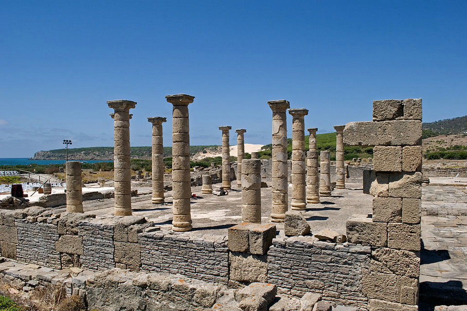
Capitol
Built between 50 and 70 AD
All three are almost identical: A, 20.23 x 8 m.; B, 20.23 x 7, 42 m.; C, 20.23 x 8, 03 m.
Origin
Temples dedicated to the cult of the Capitoline Triad.
Located on the north side of the Forum, on a platform that presents a vertical drop of five meters with respect to the paved square.
Comments
These three temples represent the official religion and also make up the sacred area of Baelo. Its dominant situation is not accidental and symbolizes the submission of administrative and political life to the deity, under whose protection citizen life develops. The temple serves only as a dwelling for the statue of the god or goddess, while the cult is developed mainly outside, especially on the altars existing at the foot of the staircase of the central building. In the official rites a great importance was given to the deified emperors.
Theater
Built in the first century AD, around the year 60 AD, it was abandoned at the end of the second century or early s. III AD
67 m of facade length by 15 m. Tall.
Origin
The theater was used for the performance of theatrical performances. After its abandonment, in late Roman times it was re-used as a necropolis.
Comments
The proliferation of doors and access corridors obeys to the fact that the placement of the spectators in the theater was predetermined. The cavea was divided into three semicircular sectors: the ima cavea – or lower grandstand – was reserved for the ruling classes of the city, with the local magistrates occupying the first seats, next to the orchestra; the middle cavea -or intermediate bleachers- was occupied by merchants and public officials, as well as by free citizens of higher status; the upper part or summa caveait was reserved for the common people, the common people. If we take into account that each sector was separated from its immediate by means of a small wall we understand the reason for the existence of so many doors.
On the sides of the pulpitum, a decorated space located just in front of the stage, there are two monumental fountains whose sculptural part represents two reclining satyrs, who feed water to the fountains from wineskins under their arms.
Behind the stage there was a great richly decorated wall – scaenae frons -, which served as the background for the theatrical performance and at the same time made a sounding board so that the voice of the actors could be amplified and reach the public.
Forum
Although the origin of the Forum of Baelo must be placed in the time of Augustus, the fundamental nucleus of the forensic area that we see today is remodeled between 50 and 70 BC (reigns of Claudius and Nero).
Forensic area: 75 x 50 m.; Forum Square: 37 x 30 m.
Origin
Essential space for public use, center of civic life in all its facets: political, administrative, judicial or religious.
Middle area of the city, central position between the canvases of the east and west walls. It communicates with the Decumanus Maximus on its southern side.
Comments
The forensic area of Baelo Claudia is, perhaps, the one that has come to us in a more complete way and the one that presents the best state of conservation of the entire Peninsula.
In imitation of Rome, the Forum was in all the cities the center of the civic life and the place of encounter and relation. For this reason they were located at the junction of the two main streets of the city or very close to it. In principle, the Forum of Baelo had various functions, among which the commercial one stood out. From the middle of the first century, this role is disappearing in all the cities of the western provinces of the Roman world. The Forum now acquires a more institutional, political and religious sense, moving commercial activity to other areas, which explains the construction of the market or “Macellum” of Baelo Claudia. The atmosphere of the forum in antiquity was more closed than we can see today. It was a space bounded by large buildings on all sides, what propitiated a space with its own entity. The side porches guarded the citizens from the inclemency of the weather.
Market (Macellum)
It was built at the end of the 1st century AD, when the Forum was closed to commercial activity. In the second century AD only the shops that open their doors to the Decumanus Maximus survive. Soon after it was completely abandoned.
Origin
Market of supplies of the city. In the second century the interior shops are used as landfill and in late period homes are built.
Comments
There are many architectural elements available: the pavement, the drains, the supports, the pilasters, the columns, the capitals, etc., which make it possible to deduce with sufficient accuracy their original condition, as well as to venture the possibility of a future architectural restoration. This action would be of great interest, considering the small number of markets that remain intact in the rest of the Roman world. The building had two levels. The stores were small, since most of the merchandise was exhibited outside of them. The building had doors that closed at night, as well as stores. The aedicule (chapel) existing in the center of the building should be dedicated to a divinity linked to commerce, possibly Mercury.
Urban hot springs
Its construction can be dated to the end of the 1st century – beginning of the 2nd century AD thanks to the inscriptions of the bricks used in its construction. The building was in use until the end of the 4th century AD
32.50 x 13.50 m. Partially excavated between 1969 and 1970. The building as a whole is 38 x 37.8 m.
Origin
The baths had a hygienic function, but they were also a space for leisure and social recreation, for relations with other citizens, where they talked, did gymnastics, took baths, etc.
Comments
Users, after accessing the thermal space, smeared with oil and massaged in the ” tepidaria ” or warm rooms, prior to access to the ” caldarium “, where they took a hot bath and repress the suffocating heat with labrum water. At the end of their rest, they crossed the warm rooms again and went to the cold bath room in the ” frigidarium “. In this there were two bathtubs, one deeper for the bathroom itself and another in the form of an apse for sprinkling.
These baths of Baelo perfectly conserve the ” hypocaustum “”or heating system, which through the permanent combustion in the furnaces allowed to have hot water and steam Many of the bricks of this construction have a seal that marks their manufacture near the neighboring Tingis (present Tangier), which corroborates a Once again, Baelo’s intense relations with North Africa.
Recently they have discovered larger thermal baths located outside the city but very close to these. They have been defined as Termas Marítimas, being located in an immediate suburb of the city but open to the sea, possibly to serve the important floating population related to port activities and fishing. Both thermal spaces are practically synchronous and were built in a period in which there was a wide development of this type of facilities in the Roman world, representing Baelo Claudia a clear exponent of it.
Decumanus Maximus
The layout corresponds to the time of Augustus, being remodeled later in line with the rest of the important works carried out in the second half of the first century AD Its abandonment, very uneven, took place throughout the late Roman period, being able to be conditioned for the tsunami that should have ravaged part of the city in the s. III AD
It has 9 m. of variable width and its total length constitutes the maximum width of the city.
Origin
Main street of the city. It opened the main shops of the city, as well as the market (macellum), the shopping plaza and the urban hot springs. This street was the commercial axis of the city.
Separates the middle zone of the city from the southern part defining an east-west axis. The confluence between this road axis and the Cardo Maximo (north-south) defined the forum of the city, the heart of public life. From the axes of the Cardo and Decumanus Maximus the vitrubian urbanism was articulated on the basis of parallel and perpendicular streets.
Comments
The Decumanus Maximus, as the main street of Baelo, communicated two of the main gates of the city and was flanked by porticos. From the Decumanus, important buildings such as the urban hot springs, the market (macellum) and the basilica were accessed, as well as connecting with the Forum. It is common to find in Roman pavements rolled car on the slabs although it is not the case of Decumanus de Baelo, which suggests that it was the main street of commerce and relationship of citizens and not the point where traffic rolled.
This road axis has been excavated around 90% of its length, constituting one of the only decumanos of our country preserved entirely.
Its layout fossilizes the coastal route that linked Gades (Cádiz) and Carteia (San Roque), the main cities that were the backbone of the Cadiz coast during antiquity and that represented two of the most outstanding enclaves of the area of the Strait in Roman times.
East Gate, also called Carte de Carteia.
The door is built around 10 BC, in the reign of Augustus. Its use is maintained until the end of the fourth century AD
Central access: 3.15 m between the towers; rectangular bastions: 6.50 x 4.50 m
Origin
Entrance of the city from the road that arrives from Carteia, giving access to the Decumanus Maximus.
Comments
In the Puerta de Carteia sector, one can clearly observe the evolution of the wall surrounding Baelo Claudia. It was built in the first century AD in two phases: the first, in the time of Emperor Augustus; and the second, under Claudio. The reduced thickness of his canvases confirms that, in full Roman peace, the main objective of the wall was not security against non-existent enemies, but served as a delimitation of the citizen area, which was the sacred space protected by the gods, called “pomoerium” ”
The Carteia Gate was excavated in 1919 by Pierre Paris, after which it was abandoned for eighty years. In 2013, its excavation has been completed by the Archaeological Ensemble and thewith collaboration from the University of Cádiz.
Basilica
It is built between 50 and 70 AD, to cease its use in the s. III AD when the building collapsed.
31.50 x 18.50 m.
Origin
Public building primarily intended for the administration of justice. It is also a place of imperial worship, business space and meeting of citizens.
It occupies all the south side of the Forum, which opens on one front, while on the other gives access to a small square that opens to the Decumanus Maximus.
Comments
The Basilica was the most monumental building of the forum, and was essentially intended for judicial activity, although the duoviros, supreme magistrates of Baelo Claudia, would have very limited powers of justice since the major causes would depend on the magistrates of the province.
In addition to the celebration of trials, the basilica probably had multiple uses. Vitrubio speaks of the basilica as a place where commercial transactions take place, under the protection of Roman law, but it also served as a meeting place for the refuge of meteorological agents.
Presiding over the basilica we can identify the colossal statue of Trajan with the magistrate’s robes, and the cornucopia of abundance. The presence of this image and the finding of several pedestals of other sculptures, possibly of members of the imperial family, make us think of the practice of the imperial cult within the Basilica.
It was built in the middle of the 1st century, closing the forensic area, possibly on a previous basilica when the forum was remodeled. Its definitive collapse came in the s. III, associated with a great earthquake. The drums of columns were located, in the excavations, glued to each other, which has allowed part of the colonnade to be restored after the excavations.
Cistern and aqueducts
Northern aqueduct and cistern: August time, possibly. Punta Paloma Aqueduct: half of the first century AD Aqueduct of Sierra de Plata: first half of the second century AD
Cistern north: 30 x 6 m. Aqueducts: Punta Paloma, 8 Km.; Sierra de Plata, 1.2 Km.; North, 4 Km.
Origin
Water supply.
Channeling from springs and elements of storage and distribution within the city.
Comments
There was a complete supply of drinking water by means of three aqueducts, highlighting the eastern, which starts from Punta Paloma, eight kilometers away, and from which there are still remains of the arcades that served to save the various streams that crossed in its layout. One of these remains of arcades is still visible very close to the eastern wall of the wall.
From the north aqueduct circular wells are conserved, as well as several stretches with remains of the canal that led to the water storage terminal cistern, in the upper part of the urban area. This had to supply water to the buildings in that area. It was partially excavated in 2000 and 2001.
Necropolis southeast
Incinerations: from the 1st century BC to the 1st century AD; Inhumations: from III AD to IV AD
It occupies a sector of 2 has
Origin
Burial place.
Southeast area of the Archaeological Ensemble, on the road that led to Carteia. Extramural.
Comments
The city of Baelo Claudia has three necropolis. Two of them located at the exit of the east and west gates of the city, marking the road; another, located to the northeast, is between the eastern aqueduct and the current access road to Bologna. The latter is the latest.
The main characteristic of the necropolis of Baelo is the incorporation of betils, which are cylindrical or frustoconical pieces with or without a base, carved in limestone, or simple quartzite pebbles that try to represent a human torso. These betils are placed outside the funerary monument and face the sea, as it happens within the collective monuments with the place for the deposit of urns. Betilos have a ritual significance perhaps related to the marine deities that can also act as protective geniuses, as a symbol of future life. They may also be related to some Greco-Roman divinity (Saturn or Bacchus) or Punic (Baal).
In Baelo we find elements that associate its necropolises with other similar ones of the North of Africa, like the turriform burials, of Punic or Libyan inspiration, that remained very valid during the Roman era.
Households. Domus of the Solar Quadrant and Domus of the West
Centuries I – III AD
Domus of the Solar Quadrant: 28 x 20 m.; Domus del Oeste: 25 x 20 m.
Origin
Probably, these houses were associated with the business of the salting industry, as the address of the owners of the factories or commercial spaces associated with their management.
South area of Baelo, within the industrial district. Both houses have access from the porticoed street traditionally known as “Cardo de las Columns” and are located facing one another generating a practically symmetrical composition.
Comments
From these houses come the best samples of pictorial art of Baelo Claudia, since almost all the rooms were originally stuccoed and decorated with paintings that reproduced, mainly, geometric or floral motifs. They were excavated between 1917 and 1921, although they have been re-excavated later, as the beach sand had reburied them.
One of these houses, the most oriental or “Solar Quadrant”, receives its current name for the discovery of a unique piece that was located inside and that is a sundial made of marble with great technical and artistic quality. In the Roman city museum you can see a copy of this piece, since the original is on display in the National Archaeological Museum (Madrid).
With regard to the other house, the Casa del Oeste, as a curiosity we must point out that, at an indeterminate moment, part of the back rooms was segregated to extend the salazonera factory located at its back, so that it could house the new circular pools or trunks that, since then, have been integrated into the largest factory in the city.
As a singularity, lastly, we can point out that during the 50s a bunker related to the coastal defense of the Strait was built on part of these houses, which was dismantled definitively in the 80s. From this defensive construction there is no more evidence that the head of a machine gun nest that is integrated under the outer footbridge that runs along the perimeter of the Roman city next to the beach.
Salting factories
The construction, use and abandonment of most of the factories excavated in Baelo can be dated at least between the 4th century AD, although it has been witnessed in the area of the beach the presence of older salting factories, which can be traced back to the s. II BC, as is the case of the one found in Punta Camarinal. Most of these industrial complexes were built during the Augustan period or during the 1st and 2nd centuries AD, and a process of abandonment was generally observed in the mid or late 20th century. II AD that affected some of these factories. Along the s. IV has been confirmed the recovery of the salazonera activity, lasting clearly until at least the following century.
Between 80 and 200 m2, with a productive capacity that reached 90 m3 in some cases.
Origin
Industrial zone dedicated mainly to the salting of fish and the production of the famous “garum” fish sauce.
They are located in the southern neighborhood of the city, intramuros, in the area closest to the beach.
Comments
The consumption needs of essential foodstuffs of the population of the great cities of the Roman Empire and the difficulty that these reached them in an acceptable state of conservation make the salting industries proliferate on the coast of Cadiz. The natural conditions of the area are exceptional for fishing, as it is a place of passage for the annual migration of tuna between the Atlantic and the Mediterranean.
The capture of the tuna in almadraba and its subsequent conservation constituted a flourishing industry and was the fundamental cause of the birth and prosperity of Baelo Claudia herself. Once the fish arrived at the factory, the fins, head, intestines and roe, as well as blood, were removed. The fish was cut and lacerated so that the salt penetrated well. Later, it was piled up in large tanks or pools, excavated at ground level, to be salted. Successively layers of fish and salt were spread in equal proportion, leaving it between one and three months on average before ending the salting. The salted fish were placed in sealed amphoras with a disk of clay, then deposited in the warehouses waiting to be moved.
The most appreciated and expensive product that was made in these factories was a sauce known as “garum” or “liquamen”. In the Greek comedies the Hispanic “garum” is already mentioned, being a highly valued product in the Mediterranean market. There was a wide range of products behind these generic definitions, as we know that some of these sauces used as a base small fish species such as sardine or anchovy, while others reused the viscera and blood of tuna, as is the case of salsa ” haimation”The garum accompanied all kinds of foods, as a dressing or seasoning, acting as seasoning and flavor enhancer, due to its characteristics it is known to have appetite stimulating properties and it has been testified that doctors or doctors used to recommend it. for its alimentary and healing faculties.
The current site
The archaeological site is next to a tourist area, so it is beginning to exploit its potential cultural tourism. The site is easily accessed and visits are free, except for foreigners who must pay a fee to visit it.
The Junta de Andalucía has built a new Visitor Reception Center (of which the architect is Guillermo Vázquez Consuegra) and has carried out a Landscape Action Project in the Ensenada de Bolonia (written and executed by the Andalusian Institute of Historical Heritage between 2010 and 2013). Likewise the University of Cádiz conducts studies of the site, giving rise to new discoveries, as the only copy of the Doryphoros of Polykleitos in Hispania.