Cavalaire-sur-Mer, French Riviera

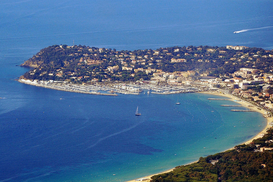
Cavalaire-sur-Mer is a French commune located in the department of Var, in the region Provence-Alpes-Côte d’Azur. Cavalaire-sur-Mer is located on the Mediterranean coast, between Saint-Tropez and Le Lavandou, in the Var department (83), at the bottom of the bay of the same name, and at the foot of the first slopes of the Massif des Maures.
Classified seaside resort in 1956, Seaside village with an excellent living environment, Cavalaire-sur-Mer is an example of the harmonious marriage between tourist activities and environmental protection.
History
Cavalaire-sur-Mer is probably derived from an ancient Phoenician colony of the name of Heracles Caccabaria. There are also remains of a Gallo-Roman occupation in Pardigon.
In the Middle Ages, “Cavalairo” or “Cavalaira” is a small land of Gassin dependent on the vast area of Jean de Cossa de la Baronnerie de Grimaud. Sheltered from both the Mistral and the Marinade, Cavalaire was the best natural anchorage on the coast of the Moors at the time. In the 14th and 15th centuries, the town’s fishing and commercial port drew a large clientele spanning Provence and the nearby Italian coasts. But in 1470 the construction of the port of Saint-Tropez by Genoese sailors replaced the commercial port of Cavalaire.
During the French Revolution, when the departments were created in 1790, the Revolutionary District decided to reunite the stronghold of Cavalaire in Gassin. The locality of Cavalaire thus remains in the 18th century a “gap” of Gassin. The Cavalairians decide to take steps to obtain their autonomy. But it was not until 139 years later, in 1929, that Cavalaire became a fully-fledged commune through the detachment of Gassin.
On the eve of the 1914 war, production capacity waned in favor of tourist prosperity: the breeding of silkworms has ceased, the coal mines have become rare, the logging is neglected. The potbellied tartans, who loaded the pine logs, the barrels of wine, the charcoal and the sand, gave way to the boats. Only the cultivation of the vine, finally rid of phylloxera, has resumed. The progress of the resort, suddenly stopped by the war, resumes its development: villas are scattering more and more in the forest and on the seaside, new hotels are being built, the beaches are furnished with parasols and deckchairs, dance halls open. With the advent of winter sports, paid holidays, and the reign of the automobile, the winter tourist season disappears in favor of the summer season.
Following the numerous steps taken by Cavalairians to obtain their administrative autonomy, they were finally granted, in 1920, to be an “Administrative Section”, which gave them relative independence (civil status was registered on the spot) then, nine years later late, they obtained their detachment from Gassin and the erection in Commune on August 5, 1929. Meanwhile, on April 29, 1921, was born the Syndicat d’Initiative de la Baie de Cavalaire, an association declared to the Prefecture under the number 102. The young town then embarked on the great adventure of its own management, soon imitated on April 6, 1934, by another “place” of Gassin: La Croix Valmer (which formerly bore the name of “La Croix-de- Cavalaire ”).
Thanks to the “Tablettes de la Côte d’Azur”, one of the rare publications of the time, we learn that in July 1926, the agglomeration of Cavalaire saw the opening of “a library abundantly supplied with books”. We can read there that in October 1926, “electricity will bring in a few days its contribution of well-being…”
Then Cavalaire knew the fate of all the municipalities of France, first shaken by the abominable slaughter of the First World War, then hit hard by the second, during which the Commune successively supported the occupation, the bombardments and Landing which took place in particular on its beach.
September 1939: the Second World War is declared, the station empties of its tourists in a few hours. All animation ceases. The scuttling of the fleet in Toulon brought the Italian occupation in November 1942, then German in 1943, which weighed heavily on the country. With the arrival of the occupier, the Resistance already existing in the region took shape and got organized. In each locality, officials are appointed with specific orders: propaganda, marine liaison, intelligence and sabotage, self-defense, preparation of the insurrectionary plan and D-Day. The coastline of the Moors becomes one of the essential zones of the Provencal Resistance, and even a key sector of the whole of the Resistance in the southern zone. A combat organization is born,
During the night of August 14 to 15, 1944, the American rangers units of the SITKA Force attacked the Levant and Port Cros islands, while a group of French commandos landed at Cavalaire. The mission of this special force is to prepare the grounding of the attack divisions, and in particular, to seize the shore batteries whose action could thwart the landing.
At the time of liberation, the balance sheet is also very heavy for the Chemins de Fer de Provence: the operation is completely suspended, the staff dispersed, several kilometers of impassable track, four bridges and eleven level crossings destroyed, eighteen damaged, many unusable buildings. Bombing and fighting put many steam locomotives, railcars, cars, vans and railcars out of service. In November 1949, the decommissioning of the railway was pronounced, as well as the provision of a number of stations for road operation (including Le Lavandou, Cavalaire, La Croix-Valmer, Cogolin, St-Tropez, Ste Maxime and St-Raphaël). Cars and wagons are cut with a blowtorch, the railroad is dismantled, the scrap goes to Italy for the overhaul; only railcars and locomotive units are sold to Spain where they are experiencing a new career.
Little by little, Cavalaire-sur-Mer becomes a seaside resort of international renown which charms year after year more and more visitors. All indulge in the pleasures of the beach, street entertainment, the discovery of heritage but also in the various sporting activities that the city offers: scuba diving, sailing, walks on the trails, hikes in the Massif des Maures … The dynamic image of Cavalaire is very real. Beyond tourism, it testifies to the identity of a city in perpetual motion. The environmental concern of the City as well as its ambitious development policy and major projects reflect this dynamism which each year attracts new inhabitants.
Tourism
The seaside location of Cavalaire, on the Mediterranean coast, allows a strong development of tourism. In addition to its 4 km of fine sandy beaches, the town has a labeled nautical station, offering several activities: diving, sailing, jet skiing, maritime excursions. The city also benefits from local activities in cities like Saint-Tropez, Ramatuelle, or Grimaud. Tourist accommodation is varied: hotels, camping, vacation homes.
Places and monuments
Church of St. Lawrence
Roman Villa of Pardigon, Roman site.
Pardigon Chapel. Formerly private funeral chapel, built in 1882 for Aimable Pardigon, former mayor of Gassin, by his widow. The chapel, which once adjoined the vast home of the Pardigon family, is now owned by the Conservatoire du Littoral. It is being restored. The walls of the building are serpentinite, the roof in slate. The walls are decorated with murals (very damaged) pretending to be a set of stones and draperies.
Les Pointus du port, still active, typical Provencal fishing boats, including the Tramontane, bought by the municipality in 1992
The fountain in rue du Port
Maison Foncin and its Mediterranean garden, property of Pierre Foncin and bequeathed by his daughters to the Conservatoire du littoral
House called Villa My plai
Underwater heritage: a dozen wrecks are located in Cavalaire bay.
Oppidum de Montjean: Ligurian period
Inter-municipal cemetery of Cavalaire-sur-Mer and La Croix-Valmer
The Domaine Foncin
Located at the western entrance to the City, the Domaine Foncin is particularly noted for its white country house, located at the top of a hill and overlooking the sea.
The estate was acquired in 1890 by Pierre Foncin, geographer, writer and co-founder of the Alliance Française. The “Casteu Dou Souleu” was built in 1894 in the middle of a cork oak forest still exploited. The family came there on vacation by train des Pignes. Since then, the “white house” has served as a bitter place for sailors and airmen, and is thus shown on navigation charts.
After the death of their father in 1917, Mireille and Myriem Foncin stayed from time to time on the estate. In 1975, Mireille Foncin settled there permanently. In 1977, she donated her property and the 15 hectares which surround it in order to guarantee its final protection: it was the first legacy made to the Conservatoire du Littoral. After his death in 1996, the Conservatoire du Littoral began serious studies, wanting to give this emblematic site an exceptional use and compatible with the wishes of the donor: education and nature protection.
Memorials:
Monument commemorating the landing and liberation of Cavalaire
Monument to the war dead of 1914-1918
Commemorative plaque
Natural heritage
In collaboration with the Ramatuelle town hall, the Var general council and the PACA regional council, the SIVOM marine observatory on the Maures coast was created in 1996. Located in the town of Cavalaire-sur-Mer, its objective is the management and observation of marine environments and their coastline.
The Pardigon Estate
On the Var coast, straddling the municipalities of Cavalaire-sur-mer and La Croix-Valmer, the Pardigon site is part of a vast green amphitheater leaning against the foothills of the Maures massif and open onto a bay bounded by a very marked relief between the Cap de la Vigie to the West and the Pointe de Vergeron to the East.
Located in one of the major places of summer vacation on the southern coast of the Bay of Saint-Tropez, this former agricultural plain is today a major break in urbanization. In the 1980s, Pardigon was the source of tensions between its owner Pierre & Vacances and local environmental protection associations. The objective of the latter was to avoid the creation of a tourist-oriented ZAC and to ensure the final protection of this place through an acquisition by the Conservatoire du littoral.
Pradels and Forest
Oriented east-west, the Pradels represent the southern link of the Massif des Maures. The interior Moors remain, despite catastrophic fires, a forest area, densely and beautifully wooded. The almost emblematic tree-king of the Moors, the providence tree too, the one on the blackened branches from which we see bouquets of young stems growing, from the spring following the fire of the previous summer, it is the cork oak (quercus suber), which its thick bark protects from fire, the tree with a blood-red trunk, when this bark has been freshly harvested (“unmasking”). If, in many places, the forest of the Little Maures seems to have already healed its wounds, as between Roquebrune-sur-Argens and the Col de Gratteloup, it is with cork oakthat it owes it largely.
The walker who takes certain tracks (in the south of the departmental 75 in particular) has the opportunity to admire multi-hundred-year-old specimens with an enormous trunk, with tormented antlers. But one also meets frequently, going up the slopes and towards the crests, the holm oak (quercus ilex), noble tree with dense and dark foliage, with less tormented habit than that of the cork oak. The downy oak (Quercus pubescens) often mixes these two species.
Comfortable on the siliceous rocks of the Moors – and often associated with cork oak – is the chestnut, one of the bases of the traditional rural economy. The oldest were planted several centuries ago, in orchards, preferably on the northern slopes (ubac), in the more humid valleys. Many of these orchards are now abandoned, but where the chestnut groves are maintained, as around Gonfaron, Mayons, Collobrières or La Garde-Freinet, they form magnificent ensembles, comparable to the Cevennes chestnut groves. example. The Moors also have – often near the ridges – remarkable pine forests (Aleppo pine and maritime pine), unfortunately more vulnerable to the fire which leaves its stigmata there. Let us also mention, at the end of this summary overview, two shrubs with evergreen foliage and very shiny in the light: the arbutus, with tasty fruits, and the holly which, in some ubacs, reaches the proportions of a beautiful tree.
French Riviera
The French Riviera is the Mediterranean coastline of the southeast corner of France. There is no official boundary, but it is usually considered to extend from Cassis, Toulon or Saint-Tropez on the west to Menton at the France–Italy border in the east, where the Italian Riviera joins. The coast is entirely within the Provence-Alpes-Côte d’Azur region of France. The Principality of Monaco is a semi-enclave within the region, surrounded on three sides by France and fronting the Mediterranean. Riviera is an Italian word that corresponds to the ancient Ligurian territory, wedged between the Var and Magra rivers.
The climate of the Côte d’Azur is temperate Mediterranean with mountain influences on the northern parts of the departments of Var and Alpes-Maritimes. It is characterized by dry summers and mild winters which help reduce the likelihood of freezing. The Côte d’Azur enjoys significant sunshine in mainland France for 300 days a year.
This coastline was one of the first modern resort areas. It began as a winter health resort for the British upper class at the end of the 18th century. With the arrival of the railway in the mid-19th century, it became the playground and vacation spot of British, Russian, and other aristocrats, such as Queen Victoria, Tsar Alexander II and King Edward VII, when he was Prince of Wales. In the summer, it also played home to many members of the Rothschild family. In the first half of the 20th century, it was frequented by artists and writers, including Pablo Picasso, Henri Matisse, Francis Bacon,h Wharton, Somerset Maugham and Aldous Huxley, as well as wealthy Americans and Europeans. After World War II, it became a popular tourist destination and convention site. Many celebrities, such as Elton John and Brigitte Bardot, have homes in the region.
The eastern part (maralpine) of the Côte d’Azur has been largely transformed by the concreting of the coast linked to the tourist development of foreigners from North Europe and the French,. The Var part is better preserved from urbanization with the exception of the agglomeration of Fréjus-Saint-Raphaël affected by the demographic growth of the maralpin coast and the agglomeration of Toulon which has been marked by urban sprawl on its part West and by a spread of industrial and commercial areas (Grand Var).