Castellane is a French commune, sub-prefecture of the department of Alpes-de-Haute-Provence in the region Provence-Alpes-Côte d’Azur. With around 1,600 inhabitants, Castellane has the distinction of being the least populated sub-prefecture in France.
The commune contains 7,000 acres of wood and forests. The Massif du Montdenier extends over the western part of the commune. The commune is part of the Jurassic limestone area of the French Prealps in Provence, formed by the tectonic upheaval of the Alps during the Tertiary. Limestone deposits run the length of the Verdon river, giving rise to spectacular gorges formed through karst erosion.
Castellane is a village in Haute-Provence, the gateway to the Gorges du Verdon and its outdoor activities. At the crossroads of the Route Napoléon and the Routes de la Lavande, in the heart of the Verdon Regional Nature Park, discover a cultural and natural heritage of rare richness.
An adventure playground for outdoor activities. Lovers of hiking, indulge in the many trails in our area. Come and discover the highest Canyon in Europe with the Blanc-Martel trail along the Gorges du Verdon. Discover the many peaks surrounding the village and enjoy the breathtaking views over the Verdon valley and Lake Castillon and its unreal colors. Embark on a whitewater activity along the Verdon in an exceptional setting. Enjoy a rafting descent to discover the Gorges du Verdon from an unusual and surprising point of view.
Characteristic village.Dominated by its “Le Roc”, a gigantic block of limestone, Castellane surprises at first glance. The village, classified as a “city of character” has managed to conserve and enhance its cultural heritage. Admire the three listed monuments of the village with the St Victor Church, the Clock Tower and the Pentagonal Tower once surrounding the ramparts. Stroll through the typical alleys of a village in Haute-Provence with its houses with colorful facades. Gain height by taking the Chemin du Roc towards the chapel and admire the view over the roofs of the village with the Verdon valley as a backdrop.
A protected territory. Located in the heart of the Verdon Regional Natural Park, enter an exceptional setting in the heart of unspoiled nature. Discover the prestigious Gorges du Verdon and their impressive cliffs sometimes exceeding 500m deep. Observe the majestic vultures that have made their home there. Come and enjoy the emerald waters of Lake Castillon, one of the wildest in Verdon.
History
Castellane’s name appeared in texts for the first time circa 965–977 as Petra Castellana. The name breaks down into three Occitan terms, pèira, castel and the suffix -ana, which means fortified rock and village, and could be translated as “Castellane rock”, in other words, the rock that has a fortified village, or simply the stronghouse or stronghold. Castellane is called Castelana in the Provençal dialect in the classical norm, or Castelano in the Mistralian.
Prehistory and antiquity
The inhabitants of Castellane are known back to a very early date. Neolithic nomads came through the area; the oldest traces date back to 6000 BC. A grotto with cave paintings exists in the commune but its location is kept confidential to protect the artwork; Bronze Age tombs have also been discovered in a cave in Castillon. Ligurian tribes occupied the territory. The Suetrii or Suètres later created an oppidum named Ducelia, near the Roc. They mined salt in the area and sold it. Most of the communes attached to Castellane today were peopled by the Suetrii. Taulanne was the exception, inhabited by the people who had their capital in Senez. (Their name is uncertain and Roman historians differ on the subject.) The region was conquered by Augustus in 14 BC. Castellane was attached to the Roman province of Alpes-Maritimes and began to grow. Homes were established in the plain, and the city was named Civitas Saliniensum (city of salt merchants). The name of the town later became Salinae.
Residents first settled on the bank of the Verdon to mine the saline sources which are still visible today. A treasure of antiquity, 34 gold coins issued by Arcadius and Honorius, were discovered in 1797 in Taloire. A limestone funerary stele for one Julius Trofimus, dating back to Roman times, was discovered near the old chapel of Notre-Dame-du-Plan. Until 1942 it was used in a retaining wall, and can be found today in the public garden of the savings bank. The inscription is included in the Inscriptions latines de Gaule narbonnaise (ILGN) collection of Gallia Narbonensis Roman inscriptions and is listed on the historic register. A diocese was founded in the fifth century: its seat was transferred to Senez before the 6th century however and despite all attempts to have it return to Castellan it remained there until it was closed in the French Revolution.
Middle Ages
In the early ninth century, the area around the current town of Castellane was inhabited by only 84 people. In 812 the area was invaded by Moors, also sometimes called Saracens; they destroyed Salines, the early settlement near the salt marshes. The inhabitants of Salines took refuge on the summit of the Roc and built a stronghold there, building the first Notre-Dame there, inaugurated in 852, in thanks for the refuge. Some vestiges of this site, which was named Sinaca in 813 and Petra Castellana in 965, are still visible at the place now known as Le Signal. People later also settled at the foot of the Roc in the valley bottom. In 852 a lord of Castellane, possibly named Guillaume won a victory against the Moors and put together a barony of 46 village communities stretching from Cotignac in Var to the south, to Thorame-Haute in the north, and from Soleilhas to Esparron-de-Verdon. The Barony was considered a small sovereign state ruled by hereditary sovereign barons.
In 1189, Baron de Castellane Boniface III was attacked by Alfonso I of Provence. He had refused to do homage, explaining that he was a vassal of the Holy Roman Empire. But in the face of brute force he was forced to bend the knee. Another war broke out in 1227 between the Provence and Boniface of Castellane, presumably the son. In 1257 Charles II—then still just prince of Salernes, gave the castle to the Austinian monks. In 1262, Charles I of Anjou defeated Boniface of Castellane and made Castelle the seat of a baile. In the thirteenth century, the family of Castellane lost possession of the city to the Counts of Provence. To protect themselves from attack, in addition to the protections for the city, Castellane built a series of fortified outposts at Demandolx, La Garde, Chasteuil, Rougon, and perhaps Taloire.[when?] In 1300 a small Jewish community of eight households was established in the area.
The Black Death reached Castellane in 1348, and was followed by a devastating flood of the Verdon River. The capture and death of Queen Joanna I of Naples created a succession issue in the county of Provence, the cities of the Union of Aix (1382–1387) supporting Charles de Duras against Louis I of Anjou. Lord of Castellane Louis d’Anduse, also often known as Lord of La Voulte, sided with the Duke of Anjou from the spring of 1382, supporting him on condition he participate in an expedition to rescue the queen. Castellane itself initially also backed the Duke, but changed allegiance in February 1386 after the Duke died, and rallied to the cause of the queen-regent, Marie de Blois. She negotiated with them, hoping to set off a chain of similar declarations of support. Guillaume de Forcalquier and his son Jean Raynaut, lords of Eoulx, submitted to the Duchess in July 1386. In 1390, Raymond de Turenne ravaged the surrounding territory and the village of Taulanne and failed to take the city, but did destroy the wooden bridge over the Verdon River.
The wooden bridge over the Verdon was rebuilt in stone in the 15th century. A monastery took care of its maintenance. The bridge on the Place Castellane put Castellane on the frequently travelled routes between the Mediterranean and the bridge over the Durance river at Sisteron. The bridge toll for the Verdon and the fair began at the end of the Middle Ages. The fair continued until the end of the Ancien Régime, assuring the town relative prosperity. In the fifteenth century, a community settled on the present site of Taloire. In the middle of the fifteenth century, the upper village was completely abandoned in favor of the lowland site.
Renaissance
At the end of the Middle Ages, the transhumance system developed enormously, herds of sheep from the coast going up into the high Alpine valleys in the summer. Some drailles (herding routes) crossed the Castellane bridge, where a toll was instituted. At the beginning of the 16th century, between 78,000 and 120,000 head were crossing each year during May and June. The imperial army of Charles V pillaged the town en 1536.
Religious unrest broke out in 1559. Brun de Caille had converted some of the townspeople of Castellane, who gathered at his home for services. A sectarian skirmish took place at his home. Huguenot captain Paulon de Mauvans, of another rich Protestant family, sacked the town in the summer of 1560, then established himself there after reaching an armistice with the governor of Provence, the count of Tende, Claude of Savoy. The town was attacked by Protestants on 4 October 1574, but the residents of Castellane and its surroundings chased them off, pursuing them as far as the clue de Taulanne. On 30 January 1586, the Baron of Allemagne and the Duke of Lesdiguières tried to surprise the town, the sneak attack was repulsed.
17th and 18th century
The plague struck the town again in 1630. The Jansenist bishop Jean Soanen tried to make the celebrations of Saint-Sacrement, Saint-Jean and Saint-Éloi more sedate and less unbridled, the youth of the town having a tradition of celebrating with drums, music and gunshots. The youth refused, resisted, made even more noise and even revolted, preventing the procession of the octave du Saint-Sacrement from leaving the church on June 22, 1710. In 1726 the youth of Robion, whom the priest wanted to prevent from dancing on Sunday, also revolted.
The Austrian-Sardinian army briefly occupied the town in 1746 during the war of the Austrian Succession. In December 1746, Provence was invaded by an Austrian-Sardinian army. A troop of 2,000 men took Castellane, then the surrounding villages, as far as the château of Trigance. After some difficulty, the Spanish and French armies coordinated a counteroffensive, which began at the start of January when French soldiers under the orders of the Count of Maulévrier took an Austrian outpost in Chasteuil.
In 1760, a tax imposed by the king of Piedmont-Sardinia on sales of cloth brought a large reduction in the town’s textile production. Production of cadis, a local form of wool, and of cordeillat, a coarse woolen fabric, continued until the Revolution, and was used by the local residents.
Until the Revolution salt was produced from two local salt marshes. On the eve of the French Revolution, several fiefs existed on the actual territory of the commune: Éoulx, Le Castellet-de-Robion (which became a barony in 1755), Chasteuil, Taulanne and Castillon, plus Castellane. On the same territory there were nine parishes: Castillon, La Baume, Taulanne, La Palud, Chasteuil, Taloire, Villars-Brandis, Robion, et Castellane. The parish of Éoulx overlapped the community of La Garde.
The city of Castellane alone paid more tax than Digne; it was an important rural town, both for its judiciary functions (with eight lawyers and five prosecutors) and for its production, with twelve factories: among which were six hat shops, two wax factories, one faïence works, one tile factory, one silk fabrication works, and the leather industry was also represented. A royal post office was also installed in Castellane near the end of the Ancien Régime.
19th century
The cloth industry, already well established in the preceding century, prospered in the first half of the 19th century. But cottage industries were replaced by the Barneaud factory, built in the late 1830s on the model of the Honnorat factory in Saint-André-de-Méouilles. It employed nine workers in 1872, then disappeared in 1878.
The Revolution and the Empire brought social reforms, including proportional taxation based on the assets. In order to put this in place on a precise basis, a land registry was drawn up. The loi de finances du 15 septembre 1807 specified its methods, but its accomplishment took time to get started, since the officials conducting the cadastre dealt with the communes in successive geographic groups. Not until 1834–1835 was the land registry known as the Napoleonic cadastre of Castellane and its associated communes finished.
The coup d’état of 2 December 1851 committed by Louis-Napoléon Bonaparte against the Second Republic provoked an armed uprising in the Basses-Alpes in defense of the Constitution. Insurgent republicans took a number of cities in the center and south of France.
20th century
On 10 September 1926, the sous-préfecture was eliminated in the economic plan of Raymond Poincaré, then re-established by the Vichy government in June 1942.
An internment camp was built in Chaudanne during World War II. The commune was liberated 18 August 1944 by the 36th division of British infantry.
In the mid-20th century wine growing for local consumption ended.
The village
Discover a region of Haute-Provence with many riches at the crossroads between the Alps and the Mediterranean. From the majestic Roc overlooking the village to the famous Gorges du Verdon via Lake Castillon, we have selected for you the top 3 must-see visits and activities for your holidays in Castellane.
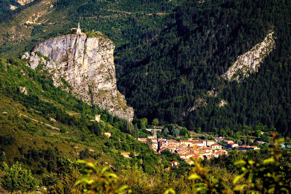
Le Roc
It is difficult when you arrive in Castellane not to be impressed by this imposing limestone cliff overlooking the village. Le Roc, a true symbol, overlooks Castellane and the Verdon valley.
Le Roc is a geological curiosity in the Verdon valley. This majestic block of limestone seems to protect the village of Castellan e nestled at its foot. It dominates the Verdon from nearly 200m high. Le Roc has been a listed natural site since 1933. The ancient village of Castellane was established there in the Middle Ages.
You will access this formidable point of view on the village of Castellane and the valley of the Verdon by a family path of 30 minutes. Several landscaped paths will allow you to gain height over the village. Take the Stations of the Cross or walk along the ancient ramparts to the Pentagonal Tower to enjoy unusual views over the roofs of Castellane.
At the end of your ascent, discover the Notre Dame du Roc chapel and its walls strewn with ex voto. Located at the top of the Rock from the 13 th century, the look you currently see only dates from the late 19 th century. Many ex-votos as a sign of thanks bear witness to the prayers that Our Lady of the Rock has answered.
Gorges du Verdon
Amazed and surprised by the discovery of the impressive Gorges du Verdon. Nearly 50 km long with cliffs reaching in places 700m deep, the Verdon has dug the largest canyon in Europe.
Many hikes will allow you to discover, as close as possible to the Verdon, breathtaking landscapes in the heart of unspoiled nature. The best known, the Blanc-Martel trail (between La Palud-sur-Verdon and Rougon) takes you to the heart of the Gorges du Verdon, at the foot of the immense cliffs, over a 15km route. Also discover the Imbut trail, more technical and sporty to discover wild and often unknown places in the canyon.
Embark on a whitewater descent to discover the Gorges du Verdon from an unusual point of view. From Castellane, many companies offer you to explore the Verdon along the water. Rafting, canoeing, water hiking, hydrospeed, there is something for everyone and for all tastes. More than 1,500 climbing routes will delight climbers in search of verticality.
Castillon lake
Enjoy the emerald-colored water, its supervised beaches and its many leisure centers at the foot of the Verdon mountains. The Castillon lake is the first encountered artificial lake on the wire Verdon. It stretches for 8 kilometers between Castellane and Saint-André-les-Alpe s and covers nearly 500 hectares. In surface area, it is the second largest lake in the Verdon valley, just behind Lake Sainte-Croix.
Quite different from a landscape point of view, Lake Castillon will remind you more of the contours of the mountain lakes of the nearby Alps. Nestled in the heart of the Verdon Regional Natural Park, this lake is a magnificent expanse of emerald colors.
Completed in 1948, after 20 years of work, the Castillon dam formed Lake Castillon. 95m high and 200m wide, you can admire, from the road bordering the lake, a breathtaking view of the Verdon downstream. Discover the impressive work on which is drawn the largest sundial in the world. Produced under the aegis of EDF and inaugurated in 2009, this work covers 13000m².
Surrounding villages
The guard
This small village of 90 inhabitants is located on the Route Napoléon, 5 km from Castellane going towards Grasse and about 20 km from the Gorges du Verdon. Nestled at the foot of the Teillon, the village still retains its aspect of a small town from the Middle Ages, with its narrow streets and its central fountain.
Soleilhas
The village is located a stone’s throw from the Côte d’Azur, within the Verdon Regional Natural Park. Soleilhas is a rural village full of assets, nestled in the hollow of the valley where the Esteron takes its source.
St Julien du Verdon
The view over Lake Castillon is omnipresent as well as the many surrounding mountains. Saint-julien-du-Verdon can be visited on foot. You have to stroll through its narrow streets, in the shade of its Provencal houses.
Demandolx
The village of Demandolx offers a breathtaking view of Lake Castillon and Lake Chaudanne. Dominated by two imposing massifs: Crémon and Teillon, the village, clinging to the mountainside, offers you a panoramic view over the entire Verdon valley.
Rougon
Rougon is a small picturesque village nestled at the foot of the remains of its medieval castle. Its high altitude location offers you a magnificent panorama of the Corridor Samson parade, the starting point of the Verdon Canyon.
Peyroules
Along the Route Napoléon, the village of Peyroules is located 15km from Castellane towards Grasse. At the heart of a long valley of hills, it brings together the hamlets of La Bâtie, Peyroules and La Foux. The village once stood on the mountainside, at an altitude of 1240m, around its castle which came under Castellane.
Resort
Val d’Allos
The Val d’Allos awaits you at the foot of the slopes of its two resorts La Foux and Le Seignus and its high mountains for an alpine landscape in the heart of the Mercantour National Park. Discover Lake Allos, the largest mountain lake in Europe, discover an extraordinary flora and fauna.
Colmars-les-Alpes
Continue your discovery along the Verdon through the medieval village of Colmars-les-Alpes. This fully fortified village of character offers you a built heritage of rare richness with its two forts classified as “sentinel of the Alps”. Discover the famous Lance waterfall and its prestigious canyon a few steps away.
Saint-André-les-Alpes
A little further down, at the gates of Provence, the village of St André les Alpes awaits you on the shores of Lake Castillon. At the crossroads of influences, the village is above all a haven of tranquility for family holidays. Want to feel? Fly in paragliding Mont Chalvet to discover panoramic views of the Verdon.
Annot
Head to Nice to discover Annot and its sandstones. These rocks, an exceptional geological formation, will be an ideal terrain for amateur bouldering climbers. A stone’s throw away, admire Entrevaux, a medieval city and its famous Vauban citadel. You can reach these two villages thanks to the Provence railways and their steam train in season.
La Palud-sur-Verdon
Finally, join the wire of the Verdon passing through Castellane to reach the village of La Palud sur Verdon in the heart of the Gorges. A preserved village in the heart of the Verdon park, La Palud invites you to discover nature. Discover the many hikes, canyons and large climbing routes in the famous canyon for a sporting holiday.
Historical heritage
The Rock which dominates the city, rising to 930 metres (3,051 feet) (over 200 metres (656 feet) above the Verdon), is a listed historical site.
The oldest monument in the territory of the commune is the dolmen of Pierres Blanches Neolithic-Chalcolithic, a registered historical site on private property. The Roc towers 184 metres (604 feet) above the community of Castellane.
The Musée des sirènes et fossiles and the Moyen Verdon are networked with other museums in the Gorges du Verdon, including the home of Pauline Gréoux-les-Bains, the museum of the life of yesteryear Esparron-de-Verdon, home gorges du Verdon in La Palud-sur-Verdon and the Museum of prehistory in Quinson gorges du Verdon.
Architectural heritage
The bridge of the Roc, which carries the Sisteron-Vence road across the river, was built in the first decade of the fifteenth century, replacing a succession of several wooden bridges, the last spanning the Verdon in 1300 and destroyed by Raimond de Turenne in 1390. The construction of the new bridge parallels that of Nyons (built in 1401, 42 m (138 ft) long), Pont de Claix (built in 1607–13, 45 m (148 ft) long), Tournon (built in the sixteenth century, 49 m (161 ft) long) and Entrechaux (24.5 m (80.4 ft) long). Pope Benedict XIII granted indulgences to anyone who gave alms to finance its construction. The rearguard of the Austrian-Sardinian army was caught there by a sortie from the garrison.
The tympana of the Roc bridge have been restored several times. Metal tie rods were laid in 1697–99. The bridge as a whole was restored in 2008 and closed to traffic. It was decommissioned in 1967 and delisted in 1982. The bridge and its approaches have been a registered historical site since 1940.
The library is in the former convent of the Visitation, founded in 1644. The eighteenth-century castle at Éoulx is richly decorated with plasterwork, including the first floor ceilings, the panels surrounding the doors, the rosette in the second-floor ceilings. Externally, it has two towers, with arched openings. The town hall is housed in the building that used to be the savings bank. It resembles a villa: balconies supported by large corbels and thick balusters, and a façade adorned with a pediment.
Catellane’s largest fountain, in the main square, features a pyramid on which is carved a compass crossed by a carpenter’s square, two chisels and a mallet, emblems of the Freemasons. At the top of the pyramid is a pedestal with a ball. On National Street, two doors have transoms or capitals with volutes, and one lintel is decorated with carved foliage. In the town, several buildings, mostly dry stone, have been recorded in the inventory of topographic DRAC. One of them, in Rayaup, dates from the eighteenth century (the inscription that says 1586 is very recent).
Notre-Dame du Roc
The Chapel of Our Lady of the Rock, dating from the High Middle Ages, dominates the city from atop the Rock and belongs to the former Convent of Mercy. But only the wall and the south façade date from the twelfth century; the building was half demolished during the wars of religion and rebuilt in 1590.
Crumbling by 1703, the chapel was again rebuilt in the early eighteenth century and once more in 1860. A capital adorned with foliage and scrolls dates from the Renaissance.
Saint-Victor
Parts of the old parish church of Saint-Victor date from the mid-11th century. It is listed as an historical building. It was constructed in a similar manner and on the same plane as the Church of St. Andrew in the old village above the modern-day town, and was formerly the seat of a priory of the Abbey of St. Victor in Marseille.
The apse is decorated with Lombard bands, which have been described as remarkable, each arch carved from a single stone. Unusually for the region, it has a Roman nave, with arches rebuilt in the 17th century. The base of the tower dates from 1445, but its top was rebuilt in the 18th century following damage by Protestants in 1560.
The altar dates from 1724. The choir is adorned with paintings framed in wood, and an Annunciation carved in relief from gilded wood (18th century, on historical register). The wooden furniture, the stalls, the pulpit and the lectern with its hexagonal base, form an interesting 18th and 19th-century set, some of which is on the historic register. The furnishings also include an early 17th-century silver chalice with an unusual multilobed foot, also on the historic register.
Other religious heritage
The Church of the Sacred Heart, now a parish church, was built in 1868–1873 by Father Pougnet and dedicated to Our Lady. It was widened by side aisles in 1896. The first transept is occupied by a platform. The interior is Gothic, with the tower built against the façade. The furnishings include some registered historical items: two silver custodes, cases for carrying communion hosts; one dating from around 1650 and one from the 18th century, a gilded wooden 18th-century cross, and a 16th-century silver chalice
the Chapel of St. Joseph is part of the Augustinian church rebuilt to replace the chapel of the Blue Penitents. It was partly demolished to widen the boulevard Saint-Michel
the 12th-century Saint Thyrse Chapel near Robion was restored in 1942 and declared a historical monument in 1944, It is the earliest Romanesque (11th and 12th centuries) church in the region.
Saint-Pons in Eoulx, unchanged since its construction, not arched, has preserved the original cornices from the middle or late twelfth century, also the thirteenth century according to the Direction régionale des affaires culturelles (DRAC). This building is on the historic register. It has a flat copper collection plate believed to be 17th-century
ruins of the Church of St. André – 13th century, in ruins since the 18th century (site of Petra Castellana)
The 12th-century church of Notre-Dame-du-Plan, a former priory in Castellane
Church of St. Sebastian Chasteuil (16th century)
Saint-Pons – 16th century, with bell dated 1436, in Robion
Saint-Jean in Taloire, may have been built as early as the 13th or 14th century, but the 15th century seems more likely. It was damaged by the earthquake of 1951.
St. Pierre in Taulanne
Saint-Jean-Baptiste in Villars-Brandis has an exceptional late 15th-century copper thurible (a type of censer) with bilevel windows.
Chapelle Sainte-Victoire in a place called Angles: late 19th century at the earliest
chapels of Saint-Pons Blaron (ex-Castillon), Saint-Antoine and Notre Dame (ruined) in Eoulx,
St. Trophimus, built into the mountain above Petit Robion after a chapel built below was repeatedly damaged by rocks falling onto its roof, has a 17th-century silver chalice and a flat copper 16th-century collection plate, both registered historical items.
St. Stephen, on high ground in Taloire
St. John, in Villars
the cemetery Notre-Dame-du-Plan includes several funeral chapels
Military architecture
The outline of the walls of Petra Castellana, the ancient city beneath the current one, is still visible, and in places they reach seven meters in height. The walls are thought to date from the 12th century, although a June 2016 archeological excavation sought to date them more precisely. Only one tower survives of the fourteen that originally reinforced these walls: the 14th-century pentagonal keep. This keep, which dominates the town center, is on private property but was declared a historic monument in 1921.
Construction on the wall enclosing the lower town began in 1359, with the permission of the Count of Provence, Louis I of Naples. Traces of this wall are still visible in the square towers on the front of the houses on the square. Corbels, which could support defenses (brattices or simple parapets with battlements) are visible on their façades.
Natural heritage
The Roc which dominates the city, rising to 930 meters (more than 200 m above the Verdon), is a natural site classified since 1933. The Roc is a natural singularity which stands out in the valley of the Verdon, and which is visible from afar; it is also classified because of its history, since the city of Castellane was established there in the High Middle Ages. Located just at the foot of the Roc, the Pont du Roc has been a site registered since 1940 (its surroundings which join the surroundings of the Roc site are also registered or classified). Finally, the largest classified site in the department, the Gorges du Verdon (7600 ha protected), have been classified from the Clue de Chasteuil since 1990. The gorges are cited in most tourist guides and present a unique landscape in France by its scale and the variety of details to be observed.
Protected areas
Castellane is located in the heart of the Verdon Regional Natural Park and the Haute-Provence Geological Reserve. Anchored in a remarkable territory with multiple riches, discover landscapes and preserved species.
The Verdon Regional Nature Park
Founded in 1997, the Verdon Natural Park straddles the departments of Var and Alpes-de-Haute-Provence and covers 180,000 hectares. The Park covers the Verdon valley from Vinon-sur-Verdon to Saint André-les-Alpes and thus encompasses the famous Gorges du Verdon. True recognition of the richness of the natural and cultural heritages of this territory, it works for their preservation by promoting the landscapes and know-how of the Verdon.
The Geological Reserve of Haute-Provence
The exceptional territory of the Geological Reserve of Haute-Provence stretches over nearly 2000km² which makes it the largest in Europe. A true museum in the open, it is intended to protect the rocks, fossils and landscape of the territory. 8km from Castellane, come and discover the Valley of the Sirens and Fossils. Due to the abundance and quality of fossils dating back 40 million years, this site is a unique geological wealth in the world.
The Verdon, lakes and gorges
The Verdon takes its source near the Col d ‘ Allos at an altitude of 2150m and continues its course for nearly 175 km before flowing into the Durance. Its name comes from its unique color, emerald green, due to the presence of microscopic algae. The Verdon dug over time a canyon 50 km in places reaching a depth of 700 meters, the Verdon Gorge. Located on the border of the Var and the Alpes de Haute-Provence, this canyon is the deepest in Europe.
Dotted with several artificial lakes, the Verdon is one of the main sources of electricity and water in the region. The Lake Castillon overlooking Castellane is spread over more than 500 hectares. The lake was formed following the construction of the Castillon dam, completed in 1948, on which is drawn the most sundial in the world. Different from Lake Sainte-Croix by its wilder and more mountainous aspect, Lake Castillon offers many water activities as well as equipped beaches. Downstream from Lake Castillon, Lake Chaudanne is the second reservoir formed by the Verdon bordering Castellane. On the steeper edges, it will offer a privileged place for fishing.
The vultures of the Verdon
Relocated in 1999 to the town of Rougon, the vultures have since taken up residence in the vertiginous cliffs of the Gorges du Verdon. Currently, more than 150 vultures inhabit the Canyon and reproduce naturally. Observe these majestic birds which can reach more than 2.5m in wingspan, while walking in the Gorges du Verdon and in particular by taking the famous Route des Crêtes and its many belvederes.