Building history of Brighton and Hove

Brighton and Hove, a city on the English Channel coast in southeast England, has a large and diverse stock of buildings “unrivalled architecturally” among the country’s seaside resorts. The urban area, designated a city in 2000, is made up of the formerly separate towns of Brighton and Hove, nearby villages such as Portslade, Patcham and Rottingdean, and 20th-century estates such as Moulsecoomb and Mile Oak. The conurbation was first united in 1997 as a unitary authority and has a population of about 253,000. About half of the 20,430-acre (8,270 ha) geographical area is classed as built up.
Brighton’s transformation from medieval fishing village into spa town and pleasure resort, patronised by royalty and fashionable high society, coincided with the development of Regency architecture and the careers of three architects whose work came to characterise the 4-mile (6.4 km) seafront. The previously separate village of Hove developed as a comfortable middle-class residential area “under a heavy veneer of [Victorian] suburban respectability”: large houses spread rapidly across the surrounding fields during the late 19th century, although the high-class and successful Brunswick estate was a product of the Regency era. Old villages such as Portslade, Rottingdean, Ovingdean and Patcham, with ancient churches, farms and small flint cottages, became suburbanised as the two towns grew and merged, and the creation of “Greater Brighton” in 1928 brought into the urban area swathes of open land which were then used for housing and industrial estates. Many buildings were lost in the 1960s and 1970s, when Brighton’s increasing regional importance encouraged redevelopment, but conservation movements were influential in saving other buildings.
Much of the city’s built environment is composed of buildings of the Regency, Victorian and Edwardian eras. The Regency style, typical of the late 18th and early 19th centuries, is characterised by pale stuccoed exteriors with Classical-style mouldings and bay windows. Even the modest two-storey terraced houses which spread rapidly across the steeply sloping landscape in the mid-19th century display some elements of this style. Extensive suburban development in Hove and the north of Brighton in the late 19th and early 20th century displays architectural features characteristic of those eras, with an emphasis on decorative brickwork and gables. Postwar developments range from Brutalist commercial and civic structures to pastiches of earlier styles. Sustainable building techniques have become popular for individual houses and on a larger scale, such as at the long-planned New England Quarter brownfield development.
Local and national government have recognised the city’s architectural heritage through the designation of listed building and conservation area status to many developments. Since 1969, 34 conservation areas have been created, covering areas of various sizes and eras; and more than 1,200 structures have listed status based on their “special architectural or historic interest”.
Historical context
Early buildings
Brighton was originally an agricultural and fishing village surrounded by fields where sheep were farmed and corn was grown. In the Saxon era, small buildings developed in an area bounded by four streets named after the points of the compass, and a church stood on higher ground inland. Modest cottages for the fishermen stood on the beach below the cliffs and the now vanished South Street. A thriving fishing industry contributed to the town’s first period of growth in the 16th and 17th centuries, but development did not expand beyond the old boundaries. The industry then contracted in the early 18th century, and depopulation occurred. Labour and land for redevelopment accordingly became cheaper, and because good travel and communication routes were already established the town was well placed to grow rapidly again when sea-bathing became fashionable in the mid-18th century. Little pre-18th century architecture remains in Brighton, therefore, although there are some individual buildings. For example, 27 King Street in North Laine is cobble-fronted and retains a timber-framed interior which could be 17th-century. Hove, meanwhile, was a single-street village with a manor house, some modest cottages and a church further inland. Although St Andrew’s Church remains in use and Hove Street survives, the manor house was demolished in 1936 and no other original buildings remain.
Early-18th-century descriptions of the old town of Brighton (the present Lanes) concentrated on how small and low the houses were, and how the lower storeys were characteristically set slightly below ground level. This, and the proximity of the houses to each other, may have offered protection against storms and flooding from the sea. (In one of the earliest descriptions of Brighton – a letter dated 1736 – the rector of Buxted claims that “we live here underground almost … the second storey is finished something under 12 feet.”) “Huddling together” may have also helped the houses survive to the present day: they were poorly built and had little structural integrity. Typical Lanes buildings are timber-framed and plastered with load-bearing walls of bungaroosh with some flint. Brick quoins and courses added strength, and façades were often studded with pebbles from the beach. These would sometimes be coated with tar to keep water out, although this only became common in the early 19th century. In The Lanes, such buildings can be seen at Bartholomews, Middle Street and Ship Street among others.
Buildings of the 16th and 17th centuries and earlier can be found in the old villages absorbed by modern Brighton and Hove. At St Wulfran’s Church, Ovingdean, the 12th-century nave and chancel replaced a Saxon structure. St Helen’s Church at Hangleton retains 11th-century herringbone masonry and other ancient fabric. The old parish churches of Patcham, Portslade, Preston, Rottingdean and Brighton itself all retain some features from the 12th to 14th centuries, although they were all subject to Victorian restoration. Hove’s oldest secular building is Hangleton Manor (now a pub), a Vernacular-style flint building with some 15th-century fabric. Little has changed since the High Sheriff of Sussex rebuilt it a century later, and the dovecote outside it is 17th-century. Other surviving manor houses and mansions in the old villages around Brighton and Hove include Preston Manor, Patcham Place, Stanmer House, Moulsecoomb Place and Ovingdean Grange, while Patcham and Rottingdean have well-preserved lesser houses such as Court House, Down House, Hillside and Southdown House, generally built of brick and flint in the 18th century.
Georgian and Regency periods
The first development outside the four-street boundary of the ancient village was in 1771–72, when North Row (soon renamed Marlborough Place) was built on the west side of the open land. Some tarred cobble-fronted buildings survive there. At the same time, inns were becoming established as fashionable venues: the Castle (demolished) and the Old Ship both had “uncommonly large and expensive” assembly rooms for dancing and high-class socialising. The Castle’s assembly rooms of 1754 were redesigned by John Crunden in 1776 in Classical style; in 1761 Robert Golden designed Palladian-style rooms for the Old Ship, later redecorated in a “[Robert] Adamish” style after Crunden’s work at the Castle. Robert Adam himself redesigned Marlborough House in 1786–87: with its elegant Neo-Palladian façade and “spatially arresting interior”, it has been called the finest house of its era in the city.
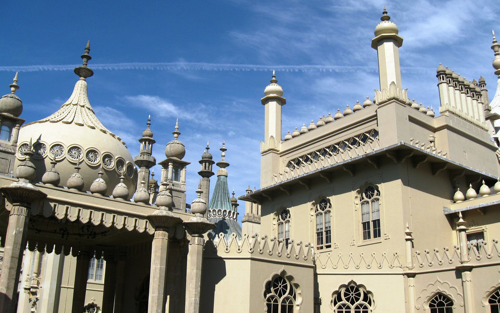
The Prince Regent visited Brighton regularly from 1783 and soon wanted a house. A building near the Castle Inn was found, and Henry Holland extended it in “a stilted Classical style” in 1786–87. The Royal Marine Pavilion, as it was called before its present name (the Royal Pavilion) was adopted, became increasingly important in the growing town as it became the centre of activities for the Prince and his entourage—and the focal point for his regularly changing architectural tastes. Holland revamped the building in 1801–04 in a Chinese style, and the French-inspired interior was changed as well. Meanwhile, William Porden added a “monumental” complex of stables (now the Brighton Dome complex) to the west in 1804–08, in an Indian style. James Wyatt and later John Nash were then commissioned to alter the building again; Nash’s work, finished in 1823, gave the building its present opulent Indo-Saracenic Revival/Orientalist appearance.
The Prince Regent’s patronage helped Brighton become a fashionable, high-class resort. As it became more popular, it further outgrew its four-street boundaries. Planned development, as opposed to ad hoc growth, started in the 1780s with North Parade and South Parade alongside Old Steine. By the 1790s it spread well to the east along the East Cliff: New Steine (1790–95, but refaced in the 1820s) was the first sea-facing square, then came Bedford, Clarence and Russell Squares (all early 19th century) and Brighton’s first crescent, Royal Crescent (1799–1802). Powered by “fashion, demand and the availability of capital”, the scale of building and architectural ambition kept growing—especially when the father-and-son architects Amon and Amon Henry Wilds and their associate Charles Busby arrived in the town. They helped to develop the Regency style which now characterises the seafront. Hanover Crescent, Montpelier Crescent, Park Crescent, the Kemp Town estate (Sussex Square, Lewes Crescent, Arundel Terrace and Chichester Terrace) and Brunswick Town (Brunswick Terrace, Brunswick Square and associated streets) were among their set-piece developments. (The Brunswick estate was also the first significant development in the parish of Hove.) Accordingly, by the early 19th century, Brighton was renowned for the splendour and “strongly individual character” of its architecture. William Cobbett claimed in 1832 that it “certainly surpass in beauty all other towns in the world”. Due to the quantity and quality of work produced by the Wilds–Wilds–Busby partnership and the groundbreaking designs produced by Holland, Nash and Porden—which “established a vocabulary of architectural elements” that defined the entire Regency style—Brighton’s early urban development was characterised by an “overflowing of architectural inventiveness”.
Around the same time, though, the first concerns were raised about the poor quality of houses on the edge of Brighton—especially on St James’s Street, Edward Street and the roads running off West and North Streets. Many reports and studies were made by the Corporation and outsiders over the next decades, but little action was taken. There was, however, some slum clearance in 1845, when Queens Road was driven through the infamous Petty France and Durham districts to provide a direct link from the station to the town centre.
Railway age and Victorian era
The London–Brighton railway reached the coast in 1841, and westward and eastward links were soon built from Brighton railway station. This was built in 1841 to David Mocatta’s Italianate design, then added to in 1882–83 when H.E. Wallis added the dramatically curved train shed and F.D. Banister made further alterations, creating a building “entirely characteristic of the greater Victorian railway station”. The line to the east crossed the landmark London Road viaduct, a 28-arch, 400-yard (370 m), sharply curving brick structure which stood in empty fields when built by John Urpeth Rastrick in 1846.
Development had not yet reached this part of Brighton because the ancient field system to the north and east of the town constrained its growth, as did the ownership by the Stanford family of most of the remaining land surrounding Brighton and Hove. They carefully controlled its sale and development, releasing parcels of land gradually and ensuring that visually cohesive planned estates of high-quality housing were built. The area’s 19th- and early 20th-century housing accordingly has a clear pattern and “a distinctive character”. The poorest housing was to the east of Brighton (slum clearance around Carlton Hill, Albion Hill and Edward Street has replaced much of this); working-class housing for tradesmen, railway workers and other artisans spread to the northeast around Lewes Road, the viaduct and the station; middle-class developments lay north of the centre around London Road; and the highest-quality suburbs developed to the northwest of Brighton and north of Hove on the Stanford family’s land. As originally built, the inner suburbs were of variable architectural quality: small houses with very late Regency-style flourishes predominated, but scattered among these were small-scale industrial and commercial development (the latter especially along the main roads), a range of high-quality Victorian churches such as St Bartholomew’s, St Martin’s and St Joseph’s, and institutional buildings such as workhouses, hospitals and schools. Improving access to education was a particular priority for Brighton Corporation in the 19th century, so straight after the Elementary Education Act 1870 was passed it set up a school board, appointed Thomas Simpson as its architect and surveyor and provided several schools in suburban areas—most of which survive with little alteration. Simpson also worked for the Hove school board from 1876, the enlarged Brighton and Preston board from 1878 and took on his son Gilbert to assist in 1890.
The coming of the railway changed Brighton from an exclusive resort to a town popular with all classes of holidaymaker and permanent resident alike: the population grew by nearly 50% in the first decade. The seafront remained the main attraction, so an array of features were added: pleasure piers, promenades, hotels, entertainment kiosks and an aquarium. The West Pier and Palace Pier date from 1863 and 1891 respectively, although both were completed several years later; Madeira Drive was laid out in 1872 and received its “signature cast-iron terrace” (including a pagoda-shaped lift decorated with Greek gods) in the 1890s; Kings Road was widened in the 1880s; and large hotels began to line it even before this. Early-19th-century hotels such as the Royal Albion, Royal York and Bedford were joined by an Italianate pair by John Whichcord Jr. (the Grand, 1864) and Horatio Nelson Goulty (the Norfolk, 1865). Then in 1890 the vast Metropole Hotel by Alfred Waterhouse “broke the orthodoxy of stucco along the seafront” due to its prominent red-brick and terracotta façade. Its deliberately different design caused shock and brought criticism, but the British Architect journal considered it “a wonderful relief” from the homogeneity of stuccoed Regency buildings. Brighton’s architecture was beginning to reflect trends in the country as a whole, but the Regency style and the Royal Pavilion’s onion-domed, minaret-studded opulence continued to influence architecture throughout the town, and on the seafront in particular.
Hove, meanwhile, was also developing rapidly—but its influences were different. Although the Brunswick estate was successful, development of the neighbouring Adelaide Crescent stalled for more than 20 years and Decimus Burton’s original design was scaled back. Next came Palmeira Square (c. 1855–1865), where the evolution from Regency to Victorian Italianate is clear, and there was some suburban development (called Cliftonville) around the new Hove railway station in the 1860s, but large tracts of land to the north and west remained undeveloped because of conditions in William Stanford’s will. Only in 1872 did these conditions expire, and over the next 30 years Hove developed into a comfortable, spacious, suburban town with “a certain gentility” which it still possesses. Architects James Knowles and Henry Jones Lanchester were involved at first, and William Willett built the streets of ornately decorated gault brick villas they designed. Next came H.B. Measures and Amos Faulkner, who introduced more architectural variety and preferred red brick; then local architects Thomas Lainson and Clayton & Black laid out further estates of spacious tree-lined avenues and large half-timbered houses in the Queen Anne Revival and Domestic Revival styles. Public buildings were also provided, such as Hove Town Hall (1882; demolished 1966), a public library (1907–08) and Hove Museum and Art Gallery (a converted villa of 1877 designed in “drab Italianate” style by Thomas Lainson). Good Gothic Revival churches of this era include Central United Reformed Church (1867 by Horatio Nelson Goulty), the “dignified and grand” Sacred Heart (1880–81 by John Crawley) and Holy Trinity (1863 by James Woodman). Specialist building development company Medical Centre Developments bought the disused Holy Trinity in February 2016 for conversion into a medical centre.
Early 20th century
Residential growth continued in the interwar and postwar periods, and the distinctive zonal pattern of development continued. Estates of council housing were built east and northeast of Brighton (at Whitehawk, Bevendean and Moulsecoomb, and in the redeveloped Carlton Hill inner suburb which had been subject to urban renewal); middle-class residential housing developed to the north in the Patcham and Preston areas; and suburbs such as Westdene, Withdean, Tongdean and West Blatchington to the northwest of Brighton and the north of Hove had an upper middle-class character. The rapid interwar suburban growth was similar to that seen throughout southeast England, but it was particularly stimulated by the introduction of electric trains on the main railway route to London—bringing a quicker and much more frequent service and increasing the attractiveness of commuting. Meanwhile, Brighton Corporation began major slum clearance operations in the 1930s when the government offered financial incentives. Moulsecoomb and the Pankhurst Avenue area near Queen’s Park, both started in the early 1920s, were the first council estates. In the former, the South Moulsecoomb area was laid out first; its 478 houses, on 94 acres (38 ha) taken from the parish of Patcham in 1920, were designed along “garden city” lines with semi-detached houses set in large green spaces. North Moulsecoomb’s 390 houses, including many brick-built terraces at a much higher density, followed from 1926. Brighton’s first council flats were the four-storey Milner (1934) and Kingswood (1938) blocks, built as part of the Carlton Hill slum clearance programme.
Several streets in central Brighton were also transformed by the Corporation in the 1920s and 1930s: they sought to improve the flow of traffic by widening main roads in the commercial heart of the town. Western Road (1926–36), West Street (1928–38) and North Street (1927–36, and again in the 1960s) were all widened. Many 19th-century buildings were demolished: on North Street, a mixture of shops, houses (some in “squalid courtyards”) and inns disappeared, on West Street all buildings on the west side (mostly large houses of the late 18th and early 19th century, when the road was high-class) were removed, and the north side of Western Road was demolished. Most buildings there were shops with tall 19th-century houses behind.
Another 1930s development could have changed the Regency face of Brighton and Hove and redefined it along Modernist lines. Wells Coates was commissioned to build a block of flats next to Brunswick Terrace. The high-class speculative development was named Embassy Court and was completed in 1935. Praise from the Architects’ Journal was matched by Alderman Sir Herbert Carden, who campaigned for every other building along the seafront to be demolished and replaced with Embassy Court-style Modernist structures, all the way from Hove to Kemp Town. He also wanted to demolish the Royal Pavilion and replace it with a conference centre. This encouraged the formation of the Regency Society, the first of many local conservation and architectural interest groups.
Postwar
The urban area was not as badly affected by World War II bombing as some coastal towns, notably Eastbourne, but some buildings were damaged or destroyed. The central arches of London Road viaduct had to be rebuilt after a direct hit left the tracks hanging in mid-air; the different coloured replacement brickwork is still visible. St Cuthman’s Church, built in 1937 on the new Whitehawk estate, was destroyed in 1943.
The first council-owned tower blocks date from 1961, when four were built on the steep slopes of Albion Hill; Highleigh, opened on 16 May 1961, was the first. Other tower blocks of ten or more floors stand in the Edward Street and Upper Bedford Street areas of Kemptown, where five were built in the mid-1960s to complete an urban renewal programme begun in 1926; Hollingdean, where the landmark Nettleton Court and Dudeney Lodge towers date from 1966; and Whitehawk, where the Corporation built four ten-storey blocks called Swanborough Flats in 1967. Meanwhile, Hove had a high proportion of multi-occupancy residential buildings. Thousands lived in small bedsits hidden “behind the classic proportions many of the older houses”: a report by the council in 1976 stated that 11,000 people in Hove lived in “substandard housing”. Given the lack of open land to build on, demolition and redevelopment was championed. Based on Herbert Carden’s pre-war suggestion, the whole of Brunswick Square, Brunswick Terrace and Adelaide Crescent were to be replaced by tower blocks after Hove Council approved plans in 1945, but public opposition was too great. Two decades later, the Conway Street redevelopment scheme (1966–67) replaced 300 slum houses on an 11-acre (4.5 ha) site near the railway station with several tower blocks. A committee was formed to ensure householders received a suitable price for their compulsorily purchased houses.
The Borough Councils changed their emphasis in the 1970s towards “densely packed low-rise flats” such as Hampshire Court (Kemptown) and Ingram Crescent (Hove). This new direction was not matched by private firms, which continued to build residential towers into the 1980s—especially in Hove. Two of the city’s tallest privately built blocks, Chartwell Court and Sussex Heights (the latter, at 334 feet (102 m), is Sussex’s tallest tower block), sit on top of Brighton’s largest postwar redevelopment scheme—the Churchill Square shopping centre. This 11-acre (4.5 ha) development by Russell Diplock & Associates (1963–68) has been condemned as “a disaster architecturally”: its vast scale and poor relationship to surrounding buildings made it “very typical of its date”. It was rebuilt as a covered shopping mall by Comprehensive Design Group (1995–98). Most other postwar schemes, whether commercial, residential or mixed-use, have amounted to small-scale infill. Brighton Square, a new pedestrian shopping square in the heart of The Lanes, dates from 1966 and is in harmony with the “intimate” surroundings in terms of scale and architecture. Elsewhere in The Lanes, Postmodern Regency-style pastiche architecture characterises infill schemes at Nile Street (1987–89 by the Robin Clayton Partnership) and Duke’s Lane (1979 by Stone, Toms & Partners). A large site between Middle Street and West Street is covered by Avalon, a curvaceous double-fronted block of flats by Christopher Richards (2004–06).
The largest redevelopment scheme in the city since Churchill Square has been the laying out of the New England Quarter mixed-use area on the site formerly occupied by Brighton railway works and Brighton station’s car park. The early buildings (2004–07 by Chetwood Associates; mostly residential) are “standard 21st-century developers’ fare”; but a second phase of building (2007–09 by Feilden Clegg Bradley Studios), with retail buildings integrated with residential blocks under the name One Brighton, is more distinctive. BioRegional and the World Wide Fund for Nature’s “One Planet Living” design principles were used to ensure the development was sustainable. The best building, a residential block, comes to “a dramatic sharp point” at an acute road junction. Sustainable design also informs smaller developments around the city: Conran and Partners’ Atlanta Apartments (2007) in Bevendean have chestnut wood cladding, recycled copper and living roofs of sedum; the Sea Saw Self-Build scheme in Whitehawk (1993) consists of 24 timber-framed houses; the Hedgehog Housing development at Bevendean (2000) is similar; and a multiple award-winning scheme for the South London Family Housing Association at Hollingdean (1988) was also built according to sustainable principles.
Heritage and conservation
Buildings have been lost to fire, damage or demolition since the urban area’s earliest days, and the frequent replacement of buildings (even those with architectural merit) by Victorian-era speculators was particularly common along the seafront. After World War II, Brighton’s seaside resort function declined, demand for housing rose and it became an important regional commercial centre. Pressure for redevelopment and the prevailing attitudes towards pre-20th-century architecture resulted in widespread demolition; many of the new buildings were architecturally unsuccessful because their scale, build quality and relationship with their surroundings were poor. In other cases, large sites stayed vacant for decades pending redevelopment. The city faces unusually severe geographical constraints—it lies between the English Channel and the South Downs (an Area of Outstanding Natural Beauty), and has continuous urban development to the east and west—and intense pressure for redevelopment continues. Nevertheless, many buildings have also been saved—not least the Royal Pavilion, which was bought by the local authorities when Queen Victoria moved out and which faced another threat in the 1930s.
National conservation groups such as The Victorian Society and The Georgian Group are active in the city, and the Regency Society was founded in 1945 to conserve Brighton’s architectural heritage in a direct response to Herbert Carden’s proposals for wholesale reconstruction. Residents’ groups such as the Regency Square Area Society undertake similar work at a local level. The Victorian Society and The Georgian Group wrote a joint report in 1990 examining postwar developments in central Brighton in the context of the older surroundings. It observed that the growth of Brighton as a commercial centre since World War II had damaged its character: “grossly inappropriate commercial development” was starting to dominate the traditional seaside resort architecture characterised by the Regency terraces and squares, the piers and the Royal Pavilion.
Demolished buildings
The Royal Suspension Chain Pier (1822–23, by Captain Samuel Brown rn) became Brighton’s first “effective focal point” after it became a fashionable seaside resort, but demolition was already under consideration by the time it was destroyed by a storm in 1896. Only some oak foundations remain, and these are only visible at low tides. Brown’s 350-yard (320 m) iron structure had Egyptian Revival towers at the landward end, and the landing stage was of Purbeck stone.
Hove’s original manor house was pulled down in 1936, despite its last owner offering it to the local council for less than its market value. John Vallance built the Georgian-style L-plan house in the late 18th century. Features included a curved porch on the inside of the “L”, a cupola-style bellcote and a Chinese Chippendale staircase inside, and some of its flint and stonework may have come from an ancient chapel nearby. Other historic Hove buildings lost in the 1930s include the Classical-style Well House at the chalybeate spring in St Ann’s Well Gardens—the Ionic-columned, colonnade-fronted structure decayed as the spring ran dry, and was demolished in 1935—and the mid 18th-century Wick House. This was owned by several important figures in local history, such as landowner Thomas Scutt, Rev. Edward Everard (associated with Brunswick Town and St Andrew’s Church at Waterloo Street) and Sir Isaac Goldsmid, 1st Baronet. Along with the neighbouring Wick Hall, designed and built between 1833 and 1840 by Decimus Burton, it was demolished in 1935 to make way for the Furze Hill mansion flats. Burton’s three-storey Wick Hall was Classical in style, with a prominent cornice, a parapet with ornate stone urns, and on the garden-facing elevation a curved bay faced with a series of Ionic columns. Collectively, these four buildings were “Hove’s oldest and most important houses”.
Postwar demolition and redevelopment has been extensive in places. An especially infamous incident occurred in 1971, when Stroud and Mew’s “Regency Gothic” Central National School in North Laine was knocked down hours before its listed status was granted: the letter was apparently delayed by a postal strike. The building dated from 1830 and was founded by Vicar of Brighton Henry Michell Wagner. Another school, the Brighton Asylum for the Blind on Eastern Road (designed by George Somers Clarke, architect of the similarly flamboyant Swan Downer School on Dyke Road) was “tragically demolished” thirteen years earlier. Built in 1860–61, it was a precise and richly decorated interpretation of the Venetian Gothic style. The Bedford Hotel, Thomas Cooper’s “distinguished” Classical-style seafront hotel of 1829, was dominated by a series of Ionic columns. Once Brighton’s highest-class hotel, its future was undecided and redevelopment was under consideration when it burnt down in 1964. The remains were quickly demolished and replaced by Sussex Heights, a white 24-storey, 334-foot (102 m) Brutalist style building by Richard Seifert completed in 1968 and nowadays itself a Grade II listed building. A different approach has been used more recently in some cases: historic and architecturally interesting façades have been retained while the rest of the site has been demolished and redeveloped. Examples of this are the former Lewes Road United Reformed Church, whose façade now hides flats, and the Brighton Co-operative store on London Road. Architects Bethell and Swannell designed the four-storey building, whose wide frontage is dominated by fluted columns of the Doric order. In 2013 all but the façade was demolished in favour of student housing.
Road schemes have long been a source of demolition and redevelopment: as early as 1902, part of the historic Brighton Brewery was removed to remove a notorious bottleneck (known locally as “The Bunion”) on Church Road in Hove. Large-scale projects then threatened several parts of central Brighton between the 1960s and 1990s, but all were abandoned. A 1973 report by town planners Hugh Wilson and Lewis Womersley, which recommended large-scale demolition in North Laine in favour of a flyover and car park, was rejected. The idea re-emerged in the late 1980s as the “Breeze into Brighton” Preston Circus Relief Road scheme, one of many ideas for the vacant Brighton Locomotive Works site now occupied by the New England Quarter; this would have replaced several buildings of historic interest on York Place and Cheapside, driven a trunk road through hundreds of houses and commercial buildings and sliced a corner off the listed Bedford Square on the seafront.
Listed buildings
In England, a building or structure is defined as “listed” when it is placed on a statutory register of buildings of “special architectural or historic interest” by the Secretary of State for Culture, Media and Sport, a Government department, in accordance with the Planning (Listed Buildings and Conservation Areas) Act 1990. English Heritage, a non-departmental public body, acts as an agency of this department to administer the process and advise the department on relevant issues. As of February 2001, Brighton and Hove had 24 Grade I-listed buildings, 70 with a status of Grade II* and 1,124 Grade II-listed buildings. Brighton and Hove City Council issues periodic summarised updates of the city’s listed building stock; the latest document was published in October 2013.
Grade I, the highest status, indicates that a building is of “exceptional interest” and greater than national importance. Grade II* is used for “particularly important buildings of more than special interest”; and Grade II, the lowest designation, is used for “nationally important buildings of special interest”. All three grades of listed status offer some protection against changes which would affect the structure’s character, from interior restoration to demolition. Proposed alterations require consent from the council, which set out its position in a document published in 1981:
Buildings listed at Grade I include the Royal Pavilion, Stanmer House, several churches, the wrecked West Pier, the main building at the University of Sussex and the principal parts of the Kemp Town and Brunswick estates. Several other 19th-century residential developments have Grade II* status: among them are Royal, Park and Adelaide Crescents, Regency Square and Oriental Place. Many more churches also have this grading. Grade II-listed buildings and structures are varied: items of street furniture (such as parish boundary markers and lamp-posts) have been listed, as have dovecots, gazebos and chimneys; hundreds of houses and cottages, either individually or as part of terraces, are included; and churches, schools and other public buildings (such as Brighton Town Hall, Portslade railway station and many pubs) have also been given Grade II status.
Listed buildings have occasionally been lost to fire or demolition, and are not always delisted (officially removed from the schedule of listed buildings). The West Pier retains Grade I listed status despite its ruined, inaccessible condition; and permission to demolish a Grade II-listed house at 128 King’s Road near Regency Square was granted in 2002 after it was damaged by fire. Holy Trinity Church in Hove, declared redundant in 2010, has been threatened with demolition since 2008. Elsewhere, in July 2010 the council announced they would move a Grade II-listed shelter on the seafront by 3 feet (0.9 m) to reduce the danger to cyclists on an adjacent cycle lane.
Since around 1990, the various councils (and later subsequently the city council) have surveyed the structural condition of all listed buildings and have provided funding “to encourage the preservation of the city’s historic building stock”, covering repairs to listed and other historic buildings, replacement of missing or damaged architectural or decorative features, and assistance to return at-risk buildings to suitable use. As early as 2003, though, the city council reported that a change in the way grants were structured meant that financial help for specific buildings may decline in favour of spending money on enhancements to wider areas.
Conservation areas
The city of Brighton and Hove has 34 conservation areas, which are defined by Sections 69 and 70 of the Planning (Listed Buildings and Conservation Areas) Act 1990 as “principally urban areas of special architectural or historic interest, the character or appearance of which it is desirable to preserve or enhance”. About 18% of the urban area is covered by this designation. Conservation areas vary in size from the 316.29 acres (128.00 ha) around Stanmer to the 1.43-acre (0.58 ha) Benfield Barn area.
Source From Wikipedia