Briançon, is a French commune located in the department of Hautes-Alpes in the Provence-Alpes-Côte d’Azur region, and historically attached to the Dauphiné. Labeled City of Art & History, Briançon is on the UNESCO World Heritage list for its Vauban fortifications, unique witnesses in Europe of military mountain architecture. Briançon is a small town in Haut-Dauphiné where three main valleys meet. The Fortifications of Vauban inscribed on the World Heritage List, embody the late 17 th century the heyday of the fortified defense system. They have helped shape the borders of Europe for two centuries and influenced architecture military in the world.
In a mineral setting bathed in light, Vauban’s fortifications shape a unique landscape and elevate the Briançon fortified system to the rank of a masterpiece of mountain fortification. Guardian of the borders, Briançon, enclosed in its ramparts, is crowned by seven works making it impregnable. Even if a significant part of these were executed after Vauban’s death, his principles were applied. This majestic and imposing site makes it possible to understand the genius of adaptation which it showed. These fortifications were included on this prestigious list with regard to their authenticity, their state of conservation, their representativeness.
Briançon is the city-center of a small agglomeration of six municipalities, the urban unit of Briançon. The territory of which Briançon is the main town is called Briançonnais; it covers the north of the Hautes-Alpes department. Briançon is considered the highest town in France (1,326 m). Briançon is the confluence between the Durance and its nearby tributaries of unequal importance: Clarée upstream, Guisane on the site of the city and Cerveyrette, immediately downstream. At a time when tourism has become the essential activity, the city plays the role of regional center for transit, commercial and cultural animation of this district of the Upper Durance. But more essential appears its role of transalpine gate because it is in control of the passage of the chain of the Alps easiest from Léman to the Mediterranean coast thanks to the pass ofMontgenèvre (1850 m) with double access both from the French side via the Lautaret to the north and the Durance valley to the south and from the Italian side to Turin to the north-east and Pignerol to the south-east.
Regarding the site, whose peculiarities determine the conditions of urbanization and its constraints, to understand the opposition between the upper town and the lower town it is necessary to refer to the times of the Quaternary glaciations. The great glacier descending from the Col du Lautaret, very thick, strongly hollowed out and widened in the shape of a trough the valley of the Guisane then the Durance to Sisteron: it is in its wide base that the site of the lower town. Its tributary, the glacier coming from the Col de Montgenèvre by Even the magnified transfluence of that coming from the Clarée was much less powerful and therefore hollowed out its valley less deeply: this is why the confluence of the two glaciers is marked by a confluence step (a kind of staircase). On the other hand, this small glacier, just before joining the big one, encountered a bar of rock harder than it could completely erode and which was shaped into a glacial lock: it is on this bump that is the upper town.
History
Municipal territory crossing at the intersection of five alpine valleys, Briançon becomes walled city from the 14 th century. Dauphinoise town, seat of important fairs, it is the capital of the Escartons.
This dense network of communications has long made Briançon appear as a land of passages, an important crossroads in the heart of the Alpine massif, offering the best conditions for the movement of people, the traffic of goods and the exchange of cultures.
Prehistory and Antiquity
The successive periods of glaciation of the Paleolithic make human settlement impossible. It was only during the Neolithic that the presence of men was supposed to be in the Briançonnais valleys. It is, however, certain in the Bronze Age and the Iron Age. The various tribes, first Ligurian, then Celto-Ligurian, live on the valley floor and draw their resources from agriculture and trade.
In the early days of Romanization, Brigantio seemed to be located in the area of what is now Champ de Mars. Briançonnais remains under Roman rule until the fall of the Roman Empire in the 5 th century.
Middle Ages
After the barbarian invasions of the IV to the IX century, the Roman city Brigantium folds in the fortified peak protection that dominates the narrow valley of the Durance; it appears to be a castellum. As part of the middle Francia (Treaty of Verdun), it then passed into the Holy Roman Empire. It was given to the Counts of Albon in 1040 (future Dauphins de Viennois), it then occupied the northern half of its current base and a district, which has now disappeared, located on the site of the Champ-de-Mars.
Briançon is located in the Dauphiné, a region which today corresponds to the departments of Isère, Drôme, and Hautes-Alpes. This province was created around Albon, near Vienna in Isere, under the authority of a wealthy family whose members were known as Dolphins in the early 13 th century.
In 1343, the inhabitants of the region, grouped together in 51 communities, signed a charter with Humbert II, the last Dauphin, guaranteeing them freedoms and granting them privileges: the great charter of Briançonnaises freedoms. In 1349, Humbert II ceded his territory to the King of France. From this date, the heir son of the reigning king bears the title of Dauphin of the Viennese.
Around 1344-1345, the town of Briançon has a surrounding wall pierced with three doors (porta Superior, porta Meana and porta Inferior),; inside, there are four quarters and, among other elements, the delphinal house, the oven, an alarm belfry, the market hall, the house of the Lombard bankers and three fountains. The Grand Béal, the canal which flows in the middle of the Grand-rue, supplies the fountains and is used for firefighting, was built in 1345.
Briançon is attached to the Kingdom of France in 1349 with the rest of Dauphiné, by the Treaty of Romans, passed between the last dauphin of Viennese, Humbert II, and the king of France Philippe VI.
In 1370, the city wall, which was formed only by private houses, was reinforced: the openings of the houses on the ground floor were closed, the streets and the gaps between the houses were sealed., we dig a moat, and towers are built, leaning against the houses. Prosperous, the city forms a formalized community with the surrounding hamlets (grouped together under the term of “third”), March 4, 1382.
The Franciscan order built its convent (des Cordeliers) between 1388 and 1391, in order to fight against Valdeism and re-evangelize the people. This convent is located within the city walls.
In 1420-1421, the town occupied the entire surface of the fortified town and suburbs were created at its gates.
Renaissance
The growth of the city, symbolized by the erection of a belfry (before 1539), was considerably slowed down by the wars in Italy and the wars of religion. At that time, the main town already corresponded to the current old town, and two small suburbs were added, one near the Porte Méane, at the bottom of the town, the other near the upper gate: the Chastelet; these two suburbs were razed at the end of the XVI century to make way for fortifications.
During the wars of religion, Briançon pushed back a first siege of Lesdiguières in 1580. After the assassination of its captain Jean Louis Borel, the city went to Lesdiguières onAugust 6, 1590.
Modern times
The Dominicans settled in the city in 1624. In 1632, the city encourages the installation of the Ursulines with the aim to facilitate the education of girls.
In 1624, a fire broke out in the middle of winter, when the water in Béal was frozen. It lasts five days and destroys 80% of the city. At that time, and despite the franchises granted to the Escartons, the salt tax was introduced in 1674. At that time, thanks to the policy of the city which funds two school teachers in the year, over 85% of men are literate. On January 26, 1692, another fire was even more destructive, because of the large supplies that had been stored in town by the army: only a few houses, the Cordeliers convent, the salt loft and the hotel du vibailli remained. It will take about ten days before anyone can access the ruins.
Due to its location near the border with the Duchy of Savoy, Briançon becomes a military town. In 1689- 1690, during the reign of King Louis XIV, a new wall is built by Hue Langrune. That same year, the rallying of the Duchy of Savoy strengthens the League of Augsburg. Vauban arrived in Briançon in the fall of 1692 following a brutal attack by the Duke of Savoy on the Alps. He finds the site difficult to develop because it is surrounded on all sides by dominant heights. On November 21 and 22, 1692, he established his project. He asks for the creation of bastions, half-moons, a false-braie on the front of Embrun. He prescribed various arrangements: deepen the ditches, consolidate the curtain walls, place guard houses, make embrasures, crossings and posterns, vault the door, build powder magazines, barracks and deepen the well of the Place d’Armes. During his second trip to Briançon, Vauban inspected the work and wrote a new memoir, dated August 24, 1700.
In 1700, Vauban was again improve the defensive systems, and, in collaboration with the best military engineers and the greatest generals, he made reinforce and improve the fortifications of the city and initiate the construction of a belt of forts around it to defend it, exploiting the relief of the mountains to occupy the key points allowing to monitor the accesses. It also equips Briançon with barracks, thus allaying the fears of the population caused by the devastating passages of the armed forces. In 1713, the Treaty of Utrecht brought the border closer to the Montgenèvre pass, which is more heavily taxed by the Duke of Savoy. Trade is permanently diverted from the city.
The town having become a border town, the Marquis d’Asfeld built a belt of forts from 1721 to 1734, linked together in particular by the Asfeld bridge: Fort des Trois Têtes, Fort du Randouillet, Fort Dauphin, Fort d’Anjou, Point du Jour redoubt and Y communication.
Malte-Brun affirms that before the French Revolution, one could still read, above one of the vestiges of the Roman walls, the following inscription: “CORNELLÆ SOLININÆ AUGUSTÆ CONJUGI”. Affirmation to qualify since the letter “J” is of recent creation (XVI century) and was once visited by the letter “I”…
It became the district capital in 1790 until 1800.
19th century
In 1815, during the Napoleonic wars, the city resisted the assaults of the Allies and the second Treaty of Paris was signed without the city having surrendered. Under the July Monarchy, the castle was destroyed and replaced by the Fort du Château.
In 1876 and 1890, two artillery batteries, called Croix de Toulouse and des Eythieux, were built. In 1891 and 1893, Le blockhaus de Malfosse was built.
The organization of Briançon experiencing significant upheaval to 19 th century. The establishment of the Schappe factory in 1842, the construction of new barracks from 1882 and the arrival of the train in 1884 initiated the development of a new district near the Durance, around the hamlet of Sainte-Catherine. The post-war period saw unprecedented changes in the landscape. Traditional agricultural activities give way to tourism and climate change: the rural landscape is replaced by the urban landscape.
In the XIX century, the region became industrialized Briancon: outside nearby factories to L’Argentière-la-Bessée, several industrial activities are implanted in Briançon. The largest in terms of manpower are the Schappe factory, which employs around a thousand workers (half of them women), and a few anthracite mines. The Schappe factory, created in 1842 in Saint-Véran, is located in Briançon in a former convent, as well as in textile workshops located in nearby towns; in 1863, in the Sainte-Catherine suburb, the imposing building of the Schappe factory, 125 x 18 m over 5 floors, was inaugurated. In 1870, 1,400 people worked at the Schappe factory, which was the maximum number of employees. This factory was one of the most important schappe combing factories in France until around 1914.
20th century
In 1907, Montgenèvre and Briançon hosted the first “ international ski competition ” in France, at the initiative of the French Alpine Club; most participants were French and Italian military.
The Second World War
During the Second World War, during the Battle of the Alps, the city was threatened by Italian cannons from the fort of Mont Chaberton. On June 21, 1940, four French 280 mm mortars opened fire by Poët Morand on the Mont Chaberton fort. Six of the eight turrets located in it are destroyed. A victory acquired following a remarkable technical success of the French mountain artillery, commanded by Lieutenant Miguet.
After invading the free zone in 1942, the Germans were in Briançon in September 1943. On August 23, 1944, Briançon was liberated for the first time by the troops landed in Provence aided by the francs tireurs and partisans maquisards, but the city was taken over a few days later by the Wehrmacht. She finally released September 7, 1944 by the 4 regiment of riflemen Moroccan of the 2 division of Moroccan infantry.
Tourism
Briançon is famous for its old town. The stronghold is made up of a considerable device imagined by Vauban and produced in particular by Tardif, director of the fortifications of the Dauphiné, and Nègre: in addition to the classic belt of fortifications that surrounds the city center, engineers have installed numerous forts on the surrounding mountains to prevent an invasion from Italy. The town’s economy is mainly geared towards tourism thanks to the quality of the heritage and the site: hotels, shops, ski resorts, cycling, hiking. In 1990, the construction and inauguration of the Prorel cable car, linking Briançon toSerre Chevalier, has considerably and durably indebted the municipality. The ski resort belongs to the domain of Serre Chevalier, which it was originally in 1941 on the site of Chantemerle.
In 1990, the town became a ski resort thanks to the commissioning of the Prorel cable car, which connected the town to the Serre Chevalier ski resort, directing the economy even more clearly around tourism, which became the main source of income for the municipality.
The upper town
Briançon had to assume very variable functions, according to the times. Each has left its mark on the current urban landscape, starting with the upper town. Its liberal status has benefited the commercial function by promoting its international influence. In the days of the Avignon papacyin particular, the Montgenèvre pass was essential for relations with Italy. A wealthy merchant class has emerged. The orthogonal plan of the old town still bears witness to these ancient times, whereas few surrounding villages have such an organization.
The two main arteries, small and large Gargouille, from upstream catchments still descend the slope with their median channel. They provided water supplies but were also used for firefighting and snow removal. For their domestic uses, the inhabitants went to draw from several beautiful stone fountains. Another testimony to this ancient prosperity: the famous Maison des Têtes, a survivor of the fire of 1692, It is adorned with medallions reproducing members of the family wearing Briançonnais style hair and was restored at the beginning of the 20th century in s’ inspiring from the House of the Heads of Valencia.
A simple castle ensured the defense of the city at the time of the Dolphins. It was very dilapidated at the end of the 17th century and on its site were rebuilt in the middle of the 19th century new military buildings called Fort du Château. But this defensive function was to take on a whole new dimension from the reign of Louis XIV, with European issues. Vauban, after a first inspection in 1692, returned in 1700 and decided to build a fortified ensemble covering the entire glacial lock. But the eastern part which dominates the Durance being naturally protected by the throat of the river, did not justify the construction of important works.
If you enter the upper town by the Porte de Pignerol on a half-moon projection, you cross a bridge beyond the guardhouse. It is not a drawbridge because we do not see the rabbets, these slots in which the chains slid for the maneuver, but a weighbridge. The larch doors are reinforced with nails. The edge of the fortified enclosure which dominates the lower town is not rectilinear but presents projections in bastions and half-moons. In front of a deep ditch is the counterguard. The works are in masonry but their mass is in earth in which the cannonballs come crashing down. The position of the bastions allowed crossfire thus preventing the approach of the enemy. The sentries stood guard in watchtowers.
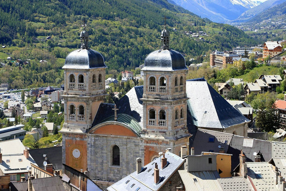
Vauban did not invent the Place d’Armes: it was already the gathering place for the population in the Middle Ages. He made it a place of parade for the military and had a well dug there as a precaution in the event of a siege. On the north side stood the “King’s House” or courthouse, prisons, prison quarters and a chapel. The time was marked on two sundials. The most important monument is the Collegiate Church, a church built between 1703 and 1718 in the classic style of the Grand Siècle. Its facade is surmounted by two bell towers crowned with domes and lanterns. His style is of military inspiration; it is decorated in the style of strongholds with a set of pilasters and pediments. It is in a way casemated because its rampart side is thickened with earth. The horizontal sundial on the ceiling (out of respect for the holy place) would also have been useful for refugees in case of danger. The population contributed to the decoration and interior furnishings (altarpieces, paintings, baptismal font).
The lower town
We can keep its old name of Sainte-Catherine. This part of the city has been profoundly transformed at first due to the foundation of the schappe factory in 1842 then, from 1884, thanks to the completion of the PLM network railway and finally from of 1895, with the installation of a large garrison.
La Schappe
The Briançonnais, given its location far from major consumption centers, could not claim an industrial vocation and we are astonished at the creation of the Schappe factory in 1842. The founders could count on pure water resources thanks to the situation on the banks of the Durance; on the availability of labor of peasant origin with little protest. We are, moreover, at the gates of Piedmont where the silk industry was very developed and where certain specialists have been recruited, mastering the techniques of the trade.
The schappe consists of silk waste: cocoons from which the butterfly is allowed to hatch to perpetuate the existence of the bombyx; doupions which are like siamese siamese cocoons; cocoons perforated by insects; cocoons with disease; friezes, that is to say the outer part of the cocoon as well as the last layer in the form of a knot in the heart of the chrysalis. This waste must first be rid of all impurities by maceration operations in the boiler room between 50 and 60 degrees and leaching and, finally, scouring: in the raw state, so-called raw silkis enclosed in an envelope to be disposed of. Then, it must be transformed into a ribbon of parallel fibers, which is generally called combing. The third operation is the spinning which is the formation of the thread itself, but it has never been done in Briançon.
The company was founded by banker Arduin and his son-in-law Chancel. The beginnings were difficult and success did not come until 1860 thanks to the quality, the moderate costs of labor and a storage policy occupying up to half the volumes of the buildings allowing to escape the volatility of commodity prices during the Civil Warin the USA. This workforce, which stabilized at around 1,000 people, was mainly recruited locally. She lived in Briançon itself and in neighboring towns, but with a fairly high turnover. It had to be supplemented by an immigration of young Piedmontese housed by the company. The Sainte-Catherine district, which, moreover, had become that of the station since 1884, has undergone profound changes, going from 131 inhabitants in 1831 to 1,307 in 1871.
Following various mergers and concentrations, the Briançon plant was integrated into a Société Industrielle de la Schappe headquartered in Switzerland and which brought together 15 factories in Switzerland and France with, in particular, the Tenay, in Ain, near Ambérieu-en-Bugey. The manufacturers could not avoid its closure in 1933 because of Japanese competition (cheaper labor) and that of artificial textiles. Of the buildings only the grim carcass of the last one remains, following a fire in 2014.
The park upstream of the factory was developed from 1815, in place of old quarries, with the addition of arable land, planting of trees and creation of a lake. In 1830, he received a gold medal from the Royal Society and Central Agriculture. The industrialists Arduin and Chancel, who lived nearby, bought it around 1850 and reserved its use. In 1954, the city of Briançon bought the park from the SIS company, then owner of the factory; a zoological park was created in 1965. In the 1960s, before the current ice rink was created, the lake was used in winter for skating. It is now a municipal park open to the public. On the side, we can see the aqueduct which diverted water from the Durance to the factory: it was supplied with water and energy, first mechanical, then electrical by creating a power station in 1918. In the entrance to the park is the keeper’s house: a bell on the roof marked the life of the workers.
Main Attractions
The Collegiate Church
The Collegiate Church of Notre-Dame-et-Saint-Nicolas dominates the ramparts of Briançon. Its history is strongly linked to the Catholic policy of Louis XIV and therefore to the important military presence in the city in the 17th and 18th centuries. The Collegiate Church was built at the beginning of the 18th century to replace the old medieval church destroyed during the construction of the ramparts. This old 12th century building was built on the road to Grenoble, in front of the cemetery. In the 16th century, the church still has its real, porch supported by stylophoric lions (preserved and placed at the entrance to the Collegiate Church, under the gallery), and its bell tower with octagonal spire, in the Lombard Romanesque style.
Located outside the city walls, it constitutes a dominant point, and therefore dangerous for the city. In 1692, it was mined and razed to the ground, on the orders of Marshal de Catinat, who feared attacks from countries united within the League of Augsburg. The Briançonnais found themselves for a time without a parish church, so Masses took place at the Cordeliers church. The Briançon consuls demanded assistance from Louis XIV to build a church inside the walls. A decision of the King’s Council in 1700 authorized the creation of a “new parish” within the city walls. A suitable location is available at the bottom of the rue du Temple. The Catholic policy of Louis XIV necessitated the establishment of an imposing edifice. The volume of the church is therefore particularly important. It contrasts with the narrowness of the temple square.
The polychromy of the facade divides the lower levels into three vertical zones. The central part, treated in stone, corresponds to the nave. It is dominated by a large arched pediment, itself framed by two bell towers, inspired by the medieval scheme. The carved walnut door was donated by Louis XIV, as evidenced by the two interlaced “L” s of the central medallions. It is surmounted by a pediment and three fire vases. An arched bay opens on the second level, framed by stone projections. The stumps of the bell towers, coated with whitewash, correspond to the aisles. They are decorated, to the south, with a sundial painted by Chalvet in 1719, and to the north with a clock. The towers are pierced by two levels of arched bays, adorned with balustrades. They have a square dome and a polygonal lantern surmounted by a globe and a cross.
The nave, wide and powerful, vaulted with ridges on double arches is flanked by simple side aisles separated by imposing square piles which support the large arches. Large smooth pilasters, of the Doric order, carry an entablature whose cornice serves as a transom for the vaults. This classic prescription, treated in faux marble, is strongly inspired by the Italian taste for trompe-l’oeil. The aisles are separated from the arms of the transept by a cross wall. Invisible from the outside, the crossing of the transept is covered with a dome on pendants. An elegant balustrade dating from the 18th century, in morello cherry limestone, forms the communion table and bars the entrance to the choir. The apse, covered with a ribbed cul-de-four, recalls the practices of the Provençal novel.
Asfeld Bridge
A true work of art, combining technical and aesthetic prowess, this bridge was built to provide a link between the upper town and the forts located on the left bank of the Durance. In his second project, dated 1700, Vauban proposed the defensive occupation of the plateau des Têtes and the junction with the city by a road crossing the Durance on a stone bridge, with two arches and a central pier. Nothing was done until 1708, when, within the framework of the war of the Spanish succession, one carried out under the direction of Marshal of Berwick, in temporary fortifications, the projects of Vauban. A road was built starting from the Porte de Pignerol, bypassing the castle to the north and crossing the Durance on a wooden bridge located lower and 200 m north of the current structure.
As part of the major works ordered by the Marquis d’Asfeld in 1720, the construction of a stone bridge became necessary. First, the access road had to be built, a difficult task that lasted nearly a year. Then after having identified the locations intended for the anchoring of the abutments (parts located on the bank intended to support the weight of the deck), a wooden scaffolding was built, with hangers, in order to install the segments (a voussoir is a freestone in the shape of a wedge or a truncated pyramid forming the apparatus of an arch, or the arch of a vault or an arch). Construction work began on the town side. Six months were needed to close the vault, then another year to complete the work, which was inaugurated with great fanfare in 1731.
This daring work consists of a single semicircular arch, 38.60 m in span 54.50 m above the average bed of the Durance river. The volume of the segments is 18 cubic feet or 0.62 m3. The walls are made of freestone tympanums in horizontal courses surmounted by a protruding plinth in the shape of a sausage carrying a parapet in freestone and covered with a protruding shelf profiled in a half cylinder. In the middle of the bridge is erected an ironwork cross surmounting a stone pyramid. A bronze plaque (facsimile of 1987 because for security reasons, the original is kept at the town hall of Briançon) gives the date 1734. Three years after the end of the work, it seems that this corresponds to the date of accession of Asfeld to the dignity of Marshal of France.
Apart from some rectifications of the access road in the 19th century, the structure has not undergone any modification. It underwent a complete restoration in 1987. The bridge is property of the City of Briançon and is part of the fortified ensemble of Briançon registered on the UNESCO World Heritage list under the Fortifications of Vauban.
Fort des Salettes
The fort, accessible from the Champ de Mars, was planned by Vauban in 1692 to occupy a flat dominating the city dangerously. Its realization, from 1709, was guided by the plans established during his lifetime. Fort des Salettes was extended between 1845 and 1850. The original 18th century structure is a redoubt, or reduced tower, inspired by the models of certain medieval towers which can be effective in mountain terrain. It was intended to prevent enemies from seizing a dominant position. Work began in 1709, under the direction of engineer Tardif and lasted until 1712.
The central tower has a square shape with cut sides. It was originally covered with a slate roof. It is surrounded by a ditch and a counter-escarp gallery with reverse fires equipped with gun slots allowing the enemy to be taken under two different directions of fire. All the originality of this work lies in the fact that the access to the gallery can only be done by an underground passage starting from the tower and therefore, hardly accessible to enemy soldiers. The tower could house a hundred soldiers and had to contain everything necessary for their subsistence. It has two levels: the first with four rooms: two guardhouses, a kitchen with a fireplace and a room with a bread oven, a powder reserve and a water tank; the second level has rifle slots and locations for light artillery. The modernization of the fort in the 19th century led to the relocation of the tower gate. It once opened on the second floor and was lowered to the level of the moat. It is protected by a small moat and a drawbridge.
Under the July Monarchy, this redoubt will be transformed into a real fort by the addition of a bastioned bunker, six Haxo-type casemates and a powder magazine. The tower will be reinforced by a roof terrace and better equipped with artillery. This set of building is in a good state of conservation. We will notice the care taken in the construction, in particular the beautiful freestone masonry. To discover, a beautiful classical decor consisting of two pilasters and a cornice, inscriptions carved in stone and royal coats of arms.
Owned by the city of Briançon, it has been maintained and run during the summer by young volunteers from the Club du Vieux Manoir for more than 30 years. It is part of the fortified ensemble of Briançon registered on the UNESCO World Heritage list under the Fortifications of Vauban.
The fort of Randouillet
Located on a narrower and steeper position than the other military structures, this fort is developed on 3 platforms. Its main role was to prevent an attack by the assailant from the ridges. The building, closed to the public, is the subject of guided tours by the Heritage Department. The Randouillet fort was built on a hill overlooking the Têtes plateau dangerously, itself commanding Briançon. As with the Fort des Têtes, after the border change of 1713, the temporary organization carried out during the War of the Spanish Succession had to be transformed into a permanent structure.
From 1718, a project was developed for the forts of Têtes and Randouillet, followed by another, reworked in 1722. Between 1724 and 1734, the sites were in full swing in Briançon with nearly 2000 workers employed on the fortifications. In 1734, the work was considered finished: the Randouillet then had its final appearance. Modernizations were carried out in 1833, with the replacement of the central battery of the keep, open to the sky, by a casemated battery à la Haxo (named after the general who modernized the French fortifications in the 19th century) with 5 rooms and after 1850, with the construction of new powder stores. Although built in the middle of the classical period, the fort practically escapes any regular bastioned scheme, given the difficulties of the terrain.
The fort consists of three parts: at the top: the keep, crowning the rocky outcrop and completely masking the rest of the hold of the fort from dangerous views. Access to the keep is through a gate protected by a zigzag drawbridge. A decoration made up of two freestone pilasters and a triangular pediment reminds the enemy of the power of the kingdom. The keep comprises the following buildings: a guardhouse, a barracks intended for the accommodation of the commander of the fort and a security garrison as well as a 60 m3 cistern, supplied by runoff; in the lower part, sheltered from enemy fire, the main buildings are three Vauban-type barracks; the third part plunges in the direction of Communication Y. There is the original entrance to the fort and a gunpowder depot.
The fort belongs to the City of Briançon and is part of the fortified ensemble registered on the UNESCO World Heritage list under the Fortifications of Vauban. The roofs of the barracks were completely restored in 2012, 2013 and 2014. This rescue was made possible thanks to the financial mobilization of the Regional Directorate of Cultural Affairs, the Regional Council, the Departmental Council and the owner.
Fort Dauphin
Designed as an advanced sentinel of the chain of 18th century fortifications, Fort Dauphin ensured the crossing of fires with Fort des Salettes in order to prevent access to the city from the Chemin du Piedmont and protected Fort des Têtes. Fort Dauphin is a “shield” structure that protects Fort des Têtes. The flat area formed by the plateau presents a danger, the enemy being able to take up position there. All the defensive equipment is turned towards the east and the mountain of the Infernet. Important embankments and earthworks were necessary to give it a regular shape, in accordance with the classical spirit and the art of bastioned fortification.
Rectangular in shape, it has 3 bastions and a half-bastion (truncated given the steep slope of the land). It is designed in 2 parts separated by a large crossbar on which the accommodation of the troops is based. The barracks housed a set of 16 cells intended to house approximately 70 men and 3 officers. It consists of 2 floors plus a basement containing the water tank. Each barrel-vaulted room contains 2 guns. These firing windows, still obstructed, were only released in the event of an attack, allowing the soldiers to retain a little more heat. The original fireplaces have been replaced by stoves on the first floor, with the exception of the one located in the officer’s room. The floor does not seem to have benefited from the laying of floors as was the case in the middle of the 19th century at Fort des Têtes.
Built between 1724 and 1734 on the Biffeul plateau, this fort has the advantage of having hardly been modified, except by the addition of a cavern gunpowder depot in 1874. Numerous projects aiming to give it more scope then followed one another. Only routine maintenance work and some improvements were made. After the war of 1870, it became obsolete and the construction of new forts (the Infernet in 1876) became necessary.
Fort Dauphin is one of the rare works that can show 18th century architectural arrangements still intact. But, its speed of construction in masonry of small coarse rubble with few freestone, its early abandonment and its isolation conducive to vandalism have left it in a very worrying state of disrepair. It is the property of the City of Briançon. Restoration work was undertaken in July 2015 in order to restore the transverse wall on which the barracks rests. The fort is part of the fortified ensemble of Briançon registered on the UNESCO World Heritage list under the Fortifications of Vauban.
Historical heritage
The urban area of Briançon, the Redoute des Salettes, the Fort des Trois-Têtes, the Fort du Randouillet, the Communication Y and the Pont d’Asfeld, were classified as World Heritage by UNESCO on July 7, 2008. This international recognition of 12 of Vauban’s most beautiful creations was initiated and actively supported by the city of Besançon through the Network of major sites of Vauban. Briançon is also classified City of Art and History. The following list only reflects a small part of the buildings listed as historical monuments, whether or not they are protected.
Elements of fortifications on the list of World Heritage
The fortifications carried out according to Vauban’s project made during the reign of Louis XIV have been on the World Heritage list since 2008.
All classified elements are made up of:
The urban wall of Briançon as well as, within the city walls, the collegiate church, the place d’Armes and the two powder magazines;
Fort Salettes, 1 quarter of the XVIII century. Facades, roofs, remains of adjoining buildings and land classified or listed as historical monuments by decree of February 14, 1989;
Fort of the Three Heads, 1 quarter of the XVIII century. Facades, roofs, remains of adjoining buildings and land classified or listed as historical monuments by decree of June 8, 1989;
Fort Randouillet, 1 quarter of the XVIII century. Facades, roofs, remains of adjoining buildings and land classified or listed as historical monuments by decree of January 26, 1989;
Communication Y, 1 quarter of the XVIII century. Facades, roofs, remains of adjoining buildings and land classified or listed as historical monuments by decree of June 8, 1989;
Asfeld Bridge, built from 1729 to 1731. Classified as historical monuments by decree of December 5, 1988.
Other military heritage
Fort d’Anjou, undated. Registered (with adjoining land) on the Supplementary Inventory of Historic Monuments by decree of October 21, 1986.
Point du Jour Redoubt, undated. Registered (with adjoining land) on the Supplementary Inventory of Historic Monuments by decree of October 21, 1986.
Fort Dauphin (built in the early XVIII century).
Fort de la Croix-de-Bretagne (built from 1876 to 1878).
Fort of Lauzette.
Fort de l’Infernet (built from 1876 to 1878).
Forts of Gondran.
Work of the Janus of the Maginot line (built in the 1930s).
Military cable car of Terre Rouge or Gondrans (built at the start of the Second World War).
Religious heritage
Notre-Dame-et-Saint-Nicolas parish church (former Notre-Dame collegiate church), built from 1705 to 1718. Classified as historical monuments by decree of October 14, 1931.
Bell tower of the old chapel of the Black Penitents, dating from the 2 half of the XVI century. Registered on the Supplementary Inventory of Historic Monuments by order of July 30, 1973.
Former Franciscan church, dating from the XIV century, the common property. Classified as historical monuments by decree of September 21, 1982.
Industrial heritage
Many coal mines operated mainly by farmers XIX and XX century.
Schappe factory, former factory (1842 – 1933) for combing silk waste. The 3,300 m was destroyed in a fire on October 5, 2014.
Power stations and electrical installations.
Other civil heritage
The Fountain of Sighs (or François I), in the Great Gargoyle, dating from the XVIII century. Listed on the Supplementary Inventory of Historic Monuments by a decree of March 18, 1930.
The facades and roofs of the “Maison du Temple”, built in 1575. Listed on the Supplementary Inventory of Historic Monuments by a decree of February 5, 1982.
The set of sundials on the facades of public buildings and private houses.
The “Pope’s House”, built in 1635, burned down in 1692 and rebuilt in 1714 – 1717. Served successively as a hospital, barracks and school for young girls.
The Récollets convent.
France, bronze monument of Antoine Bourdelle, overlooking the citadel at the top of the Castle (another version in Paris at the Palais de Tokyo). The installation of this monument is due to Maurice Petsche.
La Manne de Briançon was known as one of the seven wonders of Dauphiné. It was a very thin veil that could be seen in the morning on the larch forests in the Hautes-Alpes. This veil was composed of sweet and white grains coming from aphid droppings feeding on the sap of larches constituting a honeydew collected by bees.
Cultural space
For a small town of 12,000 inhabitants, Briançon can be proud to host a theater, a contemporary art center, two cinemas, a library and a concert hall of contemporary music.
La Ruche media library
Free and open all year round, the La Ruche media library, located in the new Cœur de Ville eco-district, is the new epicenter of culture and reading.
Contemporary Art Center
Free and open almost all year round, the Contemporary Art Center invites you to discover exhibitions of painting, sculpture, drawing, photos and visual arts.
TDB – Briançonnais Theater
Conventional scene of national interest – Art in the territory – the TDB defends an artistic project focused on contemporary creation and the emergence of new talents. Its program, eclectic and demanding, celebrates live performance in all its forms: classical and contemporary theater, dance, music, circus, street arts…
Cinemas
Ask for the program. Briançon has two dark rooms, labeled “general public” and “Art and Essay”.
Eden Studio
This cinema has a room classified as “Art house”, equipped with 3D digital projection. Access for people with reduced mobility. 98 seats.
Cosmo Cinemas
Multiplex cinema with 4 rooms: a large room with 200 seats, 3 small rooms for 200 additional seats and a snack area. 7.1 digital sound in all rooms, one of them being equipped with Dolby Atmos, the latest audio technology for total immersion in the heart of the film.
The MJC-Social Center
The Maison de la Jeunesse et de la Culture du Briançonnais is a place of meeting, sharing and learning for all. It offers a rich kaleidoscope of activities: dance, theater, music, plastic and creative arts, video, writing, energy arts…
Side B
Rehearsal and concert hall, La Face B is also an artistic place of residence and a recording studio dedicated to contemporary music.
The Briançonnais Park House
The Maison du Parc National des Ecrins presents the life of nature, men and animals of the park. Located at the foot of the Vauban city, the Maison du Parc is a place of welcome and information. It offers a permanent exhibition on the Ecrins National Park and the natural heritage of Briançonnais. Documentation, maps, topo-guides, products and works of the Park.
The Mine Museum
Created in 1990, this museum managed by the Société Géologique et Minière du Briançonnais (SGMB), in partnership with the city of Briançon, is open during the months of July and August, and on demand the rest of the year. Discover the history of the Briançonnais mines. Its objective is also to highlight the relationships that have existed between the Briançonnais and geological resources, whether it be rocks or water over the ages.
Events and Festivals
Several emblematic events punctuate the cultural calendar of Briançon.
Altitude Jazz Festival
Celebrating all kinds of jazz for all audiences in a host of venues, this nomadic festival takes place at the end of January – beginning of February and spreads throughout the Briançonnais, offering a vibrant fortnight in the heart of winter.
Medieval Festival
At the beginning of July, the Cité Vauban plunges into the heart of the Middle Ages for two days of jubilation. The alleys and gargoyles come alive with stalls of craftsmen from the past and strolls and shows punctuate the weekend.
The Offenbachiades of Briançonnais
Once a month, from October to June, great voices of lyric art perform the repertoire of Offenbach and other illustrious composers, under the direction of Jean-Christophe Keck. This last orchestra also organizes an autumn festival, Vauban en Musique.
Forts in celebration
Epic frescoes mixing theater, music and pyrotechnics storm the Fort des Têtes in July and August.
Parade of Lights
The night of December 31. Since 2018, the New Year’s Eve show at Lac de la Schappe has turned into a parade of lights. From the Cité Vauban, people with lanterns descend to the Parc de la Schappe to watch a fireworks display.
Cello Madness Festival
In July, the Cello au Sommet association organizes a week of training, concerts and meetings for cellists of all levels, all backgrounds, eager to improve, to practice ensemble music or simply to take time with their instrument.
International Choralp meetings
Intense moments of sharing music and cultures, the workshops and concerts of the international CHORALP meetings welcome without selection of any kind, and whatever their musical level, those whom the pleasure of singing brings together. In July.
The major heritage events
The Heritage Service fervently celebrates the national events Rendez-vous aux Jardins (in June) and the European Heritage Days (in September), offering the public a host of guided tours, conferences and free events. Walks and shows on heritage sites are also on the menu for summer celebrations.
Parks & gardens
City in bloom with 3 flowers, Briançon takes care of its green spaces with respect for sustainable development.
Schappe park
A green setting in the city center, it is set with a lake, an orchard and a trail of old apple trees. It was created in 1815 by Laurent Delphin, commander of the Place de Briançon, who embarked on an extravagant project: converting old arid quarries into a lush park in oriental fashion. Discover its history.
Labeled “Refuge LPO” since March 2013, the park houses games for children and a snack bar open during the tourist season.
Rosenheim Park
Located in Central Parc, this park conceals interesting tree species (sequoia, cedar…).
Chanoine Motte Park
Perched on the heights of Cité Vauban, it has two children’s play areas. Its small amphitheater predisposes it to hosting shows.
The Governor’s Garden
Jewel of the Vauban City, the Governor’s Garden is open to the public during guided tours of the City Heritage Service and the spring event “Rendez-vous aux Jardins”. In this vegetal haven overlooking the Schappe park, an old vegetable garden, a herb garden (medicinal), an ornamental garden and an aromatic garden are combined. Discover its history.
Ski area
Land of sliding, Briançon is part of the Serre Chevalier Vallée ski resort. From the city center, you can reach in a few minutes the departure of the Prorel ski lifts, the southern gate of one of the most beautiful ski areas in France. Located in the heart of a valley which offers itself to the sun more than 300 days a year, the ski area of Serre Chevalier Vallée is located between 1300 and 2800 m of altitude. With 410 hectares of slopes and a total area of 3,901 hectares, Serre Chevalier Vallée is one of the largest ski areas in Europe. In 2018, it received the Green Globe label (the sustainable development label dedicated to tourism).
Sporting events
Several highlights mark the Briançon sports calendar.
World Climbing
City-stage of the Climbing World Cup since 2011, Briançon receives in mid-July the elite of international climbing at the Parc des Sports, to the cheers of thousands of spectators. The city vibrates for a week to the rhythm of climbing and the mountain, with free events and an IFSC climbing world cup stage.
Névache Briançon half-marathon
A legendary and popular race, the Névache-Briançon half-marathon takes place in mid-August. Its 21.3 km course and its 400-meter drop make it one of the biggest classic events in France.
The Gravity Gates
This spectacular urban downhill mountain bike race is held in August. The riders evolve in the ramparts of the Cité Vauban and in the streets of the city as true aerobatic professionals.
Cutting chicks
Every year, in March, the Briançon slalom stadium hosts this legendary regional race which was created in 1952, under the leadership of the CSHB.
The Bauer trophy for little champions
Largest minor hockey gathering in Europe, this event takes place in April in Briançon, Gap and Orcières Merlette 1850. It gives young Hauts-Alpins the chance to compete against European opponents.