Acoustic wayfinding

Acoustic wayfinding is the practice of using the auditory system to orient oneself and navigate physical space. It is commonly used by the visually impaired, allowing them to retain their mobility without relying on visual cues from their environment.
Acoustic source localization
Acoustic source localization is the task of locating a sound source given measurements of the sound field. The sound field can be described using physical quantities like sound pressure and particle velocity. By measuring these properties it is (indirectly) possible to obtain a source direction.
Acoustic location is the use of sound to determine the distance and direction of its source or reflector. Location can be done actively or passively, and can take place in gases (such as the atmosphere), liquids (such as water), and in solids (such as in the earth). Active acoustic location involves the creation of sound in order to produce an echo, which is then analyzed to determine the location of the object in question. Passive acoustic location involves the detection of sound or vibration created by the object being detected, which is then analyzed to determine the location of the object in question. Both of these techniques, when used in water, are known as sonar; passive sonar and active sonar are both widely used.
Acoustic mirrors and dishes, when using microphones, are a means of passive acoustic localization, but when using speakers are a means of active localization. Typically, more than one device is used, and the location is then triangulated between the several devices.
As a military air defense tool, passive acoustic location was used from mid-World War I to the early years of World War II to detect enemy aircraft by picking up the noise of their engines. It was rendered obsolete before and during World War II by the introduction of radar, which was far more effective (but interceptable). Acoustic techniques had the advantage that they could ‘see’ around corners and over hills, due to sound diffraction.
Traditionally sound pressure is measured using microphones. Microphones have a polar pattern describing their sensitivity as a function of the direction of the incident sound. Many microphones have an omnidirectional polar pattern which means their sensitivity is independent of the direction of the incident sound. Microphones with other polar patterns exist that are more sensitive in a certain direction. This however is still no solution for the sound localization problem as one tries to determine either an exact direction, or a point of origin. Besides considering microphones that measure sound pressure, it is also possible to use a particle velocity probe to measure the acoustic particle velocity directly. The particle velocity is another quantity related to acoustic waves however, unlike sound pressure, particle velocity is a vector. By measuring particle velocity one obtains a source direction directly. Other more complicated methods using multiple sensors are also possible. Many of these methods use the time difference of arrival (TDOA) technique.
Some have termed acoustic source localization an “inverse problem” in that the measured sound field is translated to the position of the sound source.
Wayfinding
Wayfinding encompasses all of the ways in which people (and animals) orient themselves in physical space and navigate from place to place. Historically, wayfinding refers to the techniques used by travelers over land and sea to find relatively unmarked and often mislabeled routes. These include but are not limited to dead reckoning, map and compass, astronomical positioning and, more recently, global positioning.
Wayfinding can also refer to the traditional navigation method used by indigenous peoples of Polynesia. The ancient Polynesians and Pacific Islanders mastered the methods of wayfinding to explore and settle on the islands of the Pacific, many using devices such as the Marshall Islands stick chart. With these skills, some of them were even able to navigate the ocean as well as they could navigate their own land. Despite the dangers of being out at sea for a long time, wayfinding was a way of life. Today, The Polynesian Voyaging Society tries-out the traditional Polynesian ways of navigation. In October 2014, the crew of the Hokuleʻa arrived on another island in Tonga.
Recently, wayfinding has been used in the context of architecture to refer to the user experience of orientation and choosing a path within the built environment. Kevin A. Lynch used the term (originally “way-finding”) for his 1960 book The Image of the City, where he defined way-finding as “a consistent use and organization of definite sensory cues from the external environment.”
In 1984 environmental psychologist Romedi Passini published the full-length “Wayfinding in Architecture” and expanded the concept to include the use of signage and other graphic communication, visual clues in the built environment, audible communication, tactile elements, including provisions for special-needs users.
The wayfinding concept was further expanded in a further book by renowned Canadian graphic designer Paul Arthur, and Romedi Passini, published in 1992, “Wayfinding: People, Signs and Architecture.” The book serves as a veritable wayfinding bible of descriptions, illustrations, and lists, all set into a practical context of how people use both signs and other wayfinding cues to find their way in complex environments. There is an extensive bibliography, including information on exiting information and how effective it has been during emergencies such as fires in public places.
Wayfinding also refers to the set of architectural or design elements that aid orientation. Today, the term wayshowing, coined by Danish designer Per Mollerup, is used to cover the act of assisting way finding. He describes the difference between wayshowing and way finding, and codifies the nine wayfinding strategies we all use when navigating in unknown territories. However, there is some debate over the importance of using the term wayshowing, some argue that it merely adds confusion to a discipline that is already highly misunderstood.
In 2010 American Hospital Association published “Wayfinding for Health Care: Best Practices for Today’s Facilities”, written by Randy R. Cooper. The book takes a comprehensive view of Wayfinding specifically for those in search of medical care.
Whilst wayfinding applies to cross disciplinary practices including architecture, art and design, signage design, psychology, environmental studies, one of the most recent definitions by Paul Symonds et al. defines wayfinding as “The cognitive, social and corporeal process and experience of locating, following or discovering a route through and to a given space”. Wayfinding is an embodied and sociocultural activity in addition to being a cognitive process in that wayfinding takes place almost exclusively in social environments with, around and past other people and influenced by stakeholders who manage and control the routes through which we try to find our way. The route is often one we might take for pleasure, such as to see a scenic highway, or one we take as a physical challenge such as trying to find the way through a series of caves showing our behavioural biases. Wayfinding is a complex practice that very often involves several techniques such as people-asking (asking people for directions) and crowd following and is thus a practice that combines psychological and sociocultural processes.
In addition to the built environment, the concept of wayfinding has also recently been applied to the concept of career development and an individual’s attempt to create meaning within the context of career identity. This was addressed in late August, 2017 in the NPR podcast You 2.0: How Silicon Valley Can Help You Get Unstuck. The wayfinding concept is also similar to information architecture, as both use information-seeking behaviour in information environments.
Acoustic wayfinding Method
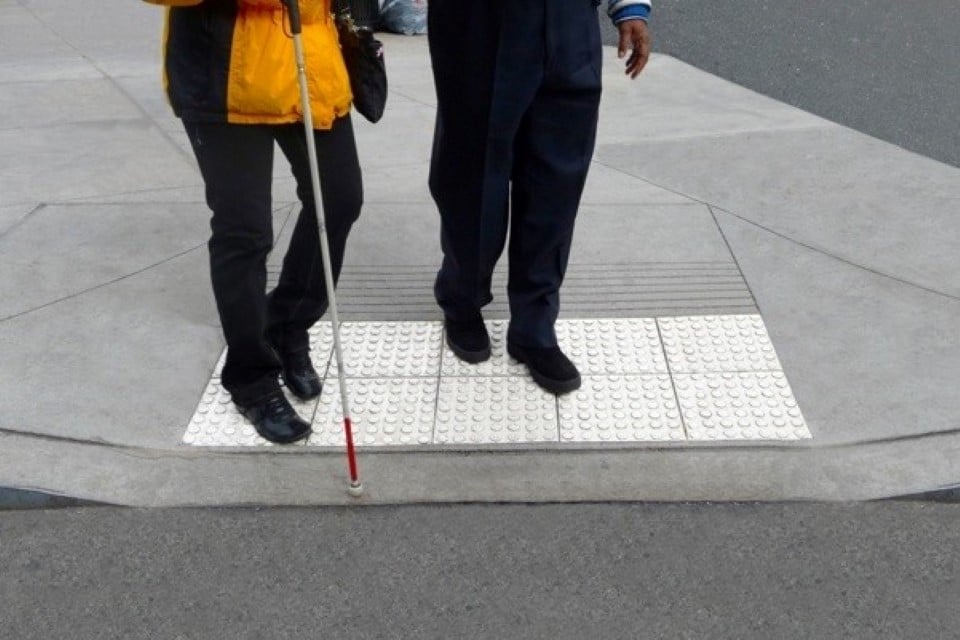
Acoustic wayfinding involves using a variety of auditory cues to create a mental map of the surrounding environment. This can include a number of techniques: navigating by sounds from the natural environment, such as pedestrian crossing signals; echolocation, or creating sound waves (by tapping a cane or making clicking noises) to determine the location and size of surrounding objects; and memorizing the unique sounds in a given space to recognize it again later. For the visually impaired, these auditory cues become the primary substitute for visual information about the direction and distance of people and objects in their environment. However, there are a number of common obstacles to acoustic wayfinding techniques: noisy outdoor environments can challenge an individual’s ability to identify useful sounds, while indoors, the architecture may not provide an acoustic response which is useful for orientation and destination.
Among the most difficult environments to navigate for individuals who rely on acoustic wayfinding are crowded places like department stores, transit stations, and hotel lobbies, or open spaces like parking lots and parks, where distinct sound cues are lacking. This means that, in practice, individuals who navigate primarily by acoustic wayfinding must also rely on a number of other senses – including touch, smell, and residual sight – to supplement auditory cues. These different methods can be used in tandem. For example, visually impaired individuals often use a white cane, not only to physically locate obstacles in front of them, but also to acoustically get a sense of what those obstacles may be. By tapping the cane, they also create sound waves that help them to gauge the location and size of nearby objects.
Importance in architecture
Recently, architects and acousticians have begun to address the problems faced by people who rely primarily on acoustic wayfinding to navigate urban spaces. The primary work on the architectural implications of acoustic wayfinding comes from a collaboration between Christopher Downey, an architect who went blind in 2008 and has since worked to improve architectural design for the visually impaired, and Joshua Cushner, who leads the Acoustic consulting practice for engineering design firm Arup in San Francisco. Their work focuses on how to plan new facilities to include sensible systems of sound markers and architectural spaces which provide orientation through acoustic cues.
On 20 September 2011, the San Francisco chapter of the American Institute of Architects organized an acoustic wayfinding discussion and walking tour, led by Chris Downey and Joshua Cushner. The purpose of the tour was to highlight the ways that visual impaired people associate sounds with particular buildings and locations, creating “sound markers” that help them find their way on the street or indoors, and to discuss implementing more unique sound markers into urban design projects.